![]()
Prev Page--Introduction || Next Page--Geology
Geography
Topography and Drainage
Jewell County lies in the Great Plains Pliocene to Cretaceous ground-water province (Meinzer, 1923, p. 310). The county has three types of topography: the deeply dissected uplands, which are typical of Cretaceous areas and which cover the northern and central parts of the county; the level or gently sloping plain, which bounds the uplands on the east and south; and the alluvial valleys.
The major topographic features of Jewell County are controlled by the underlying bedrock or have been modified by the Pleistocene history of deposition and erosion. Figure 3 shows the major physiographic divisions of the county and the principal features are described briefly below.
Figure 3--Physiographic divisions of Jewell County.
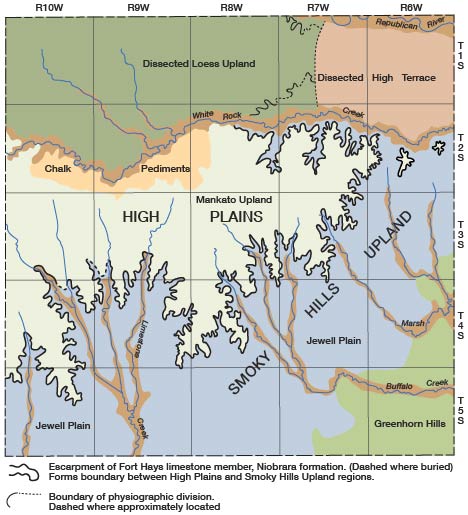
The Greenhorn hills in the southeastern part of the county are a series of rolling rocky hills, moderately dissected, and utilized principally for pasture land. They are formed by the cropping out of the resistant Greenhorn limestone, which makes prominent escarpments along Marsh and Buffalo creeks. The hills are covered with a thin discontinuous mantle of loess, which in places drapes across and obscures the escarpment.
The Jewell plain is one of the most striking physiographic features in Jewell County (Pl. 3B). In general, it is bounded on the northwest by the Niobrara escarpment and on the southeast by the Greenhorn hills so that it corresponds to the outcrop area of the Carlile shale. Along the foot of the prominent escarpment of the Fort Hays limestone member of the Niobrara formation, slopes on the Carlile shale are intricately dissected and locally form small badland areas. This slope area is not a part of the Jewell plain; it is narrow and insignificant areally and is included in the Jewell plain for simplification. The plain, which is typically very gently rolling and in places almost featureless, is intensively cultivated, for the flat gentle slopes are easy to cultivate and the loess soil is fertile. Locally, hills of shale rise 40 or 50 feet above the general level of the plain, which is crossed by many streams, including Limestone, Buffalo, and Marsh creeks and their tributaries.
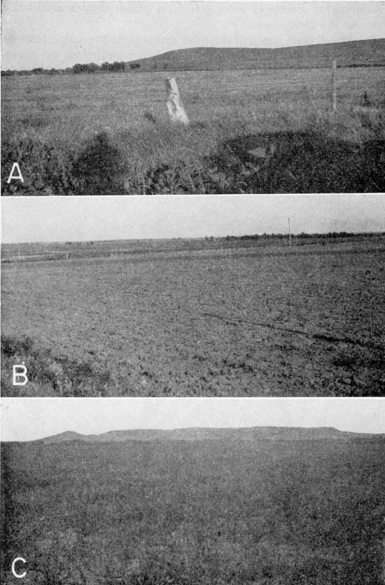
Plate 3--Surface features of Jewell County. A, Late Wisconsinan terrace of Buffalo Creek valley in the SW sec. 12, T. 5 S., R. 6 W.; hills of Greenhorn limestone in distance. B, Flat featureless surface of the Jewell plain. View southeastward from the NE sec. 25, T. 4 S., R. 7 W. C, Flat terrace-like surface of Pleistocene deposits in northeastern Jewell County; outlier of Fort Hays limestone member of Niobrara formation in background. View southeastward from the SW sec. 2, T. 2 S., R. 6 W.
The Niobrara escarpment, formed by the Fort Hays limestone member, is one of the most prominent limestone escarpments in Kansas. It crosses Jewell County as a sinuous wall extending from north of the southwestern corner to near Lovewell in the northeastern part. At Lovewell it swings westward along the south bluff of White Rock Creek, passing beneath the alluvial deposits about half way across the county. Small areas of the escarpment are observed north of White Rock Creek, but in that area most of the escarpment is covered with Pleistocene loess, has been eroded away, or is covered by stream deposits of the ancient Republican River. Near Lovewell, two outliers of the Fort Hays limestone member occur east of the principal escarpment. This escarpment forms the boundary between the High Plains on the west and the Smoky Hills on the east (Frye and Leonard, 1952, Fig. 16). These regions are part of the Great Plains physiographic province.
West and northwest of the Niobrara escarpment is a dissected upland area here called the Mankato upland. This upland is underlain by bedrock of the Niobrara formation at a relatively shallow depth. The loess cover overlying the bedrock is generally less than 10 feet thick. The area is moderately to deeply dissected along its margins where the Niobrara formation is cut through. Most of the upland is rolling hills and ridges and the streams are moderately entrenched. Locally, the Niobrara formation is eroded to form elliptical or irregularly shaped hills. The northwestern part of the area is more typical of the High Plains of which the area is a part (Frye and Leonard, 1952, pp. 201-202).
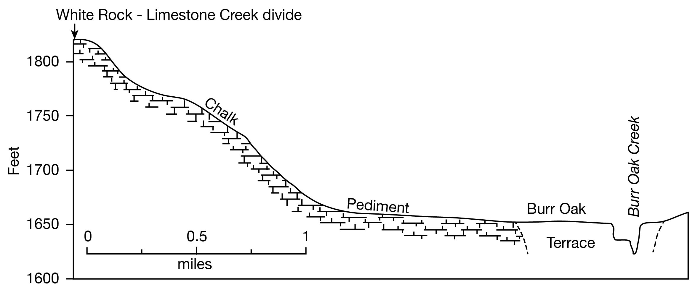
Just north of the northwestern part of the Mankato upland and between the upland and the alluvial valley of White Rock Creek is an area averaging about 2 miles in width and 12 miles in length here called the chalk pediments. This area is formed by a series of "flanking pediments" developed on the soft chalk of the Smoky Hill chalk member of the Niobrara formation. The chalk has been eroded to form smooth slopes that are concave upward and extend from near the stream divide on the south to the alluvial terrace along White Rock Creek on the north (Pl. 4A). Generally, the chalk slopes are covered with only a few inches of silt and soil (Pl. 4B) and locally weathered chalk is exposed in fields on the pediment surfaces. Near Burr Oak the surface of the pediment declines from an altitude of about 1,820 feet near the divide to about 1,680 feet near the stream, a distance of 2 miles (Fig. 4).
Plate 4--Surface features of Jewell County. A, Flanking pediment developed on Smoky Hill chalk member of Niobrara formation in the N2 sec. 35, T. 2 S., R. 9 W. B, Thin soil cover overlying Smoky Hill chalk member beneath surface of flanking pediment, SW sec. 26, T. 2 S., R. 9 W. C, Flood plain of Republican River and bluff formed by Peoria silt member of Sanborn formation. View southwestward from NE sec. 4, T. 1 S., R. 7 W.
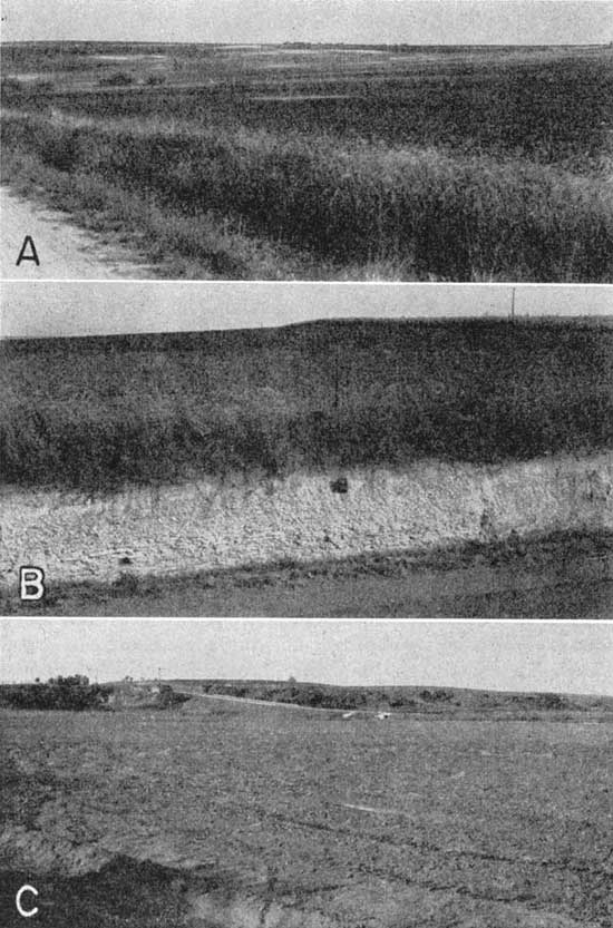
Figure 4--Profile across White Rock Creek Valley and chalk pediments along Kansas Highway 28. (Profile at angle to pediment and valley.)
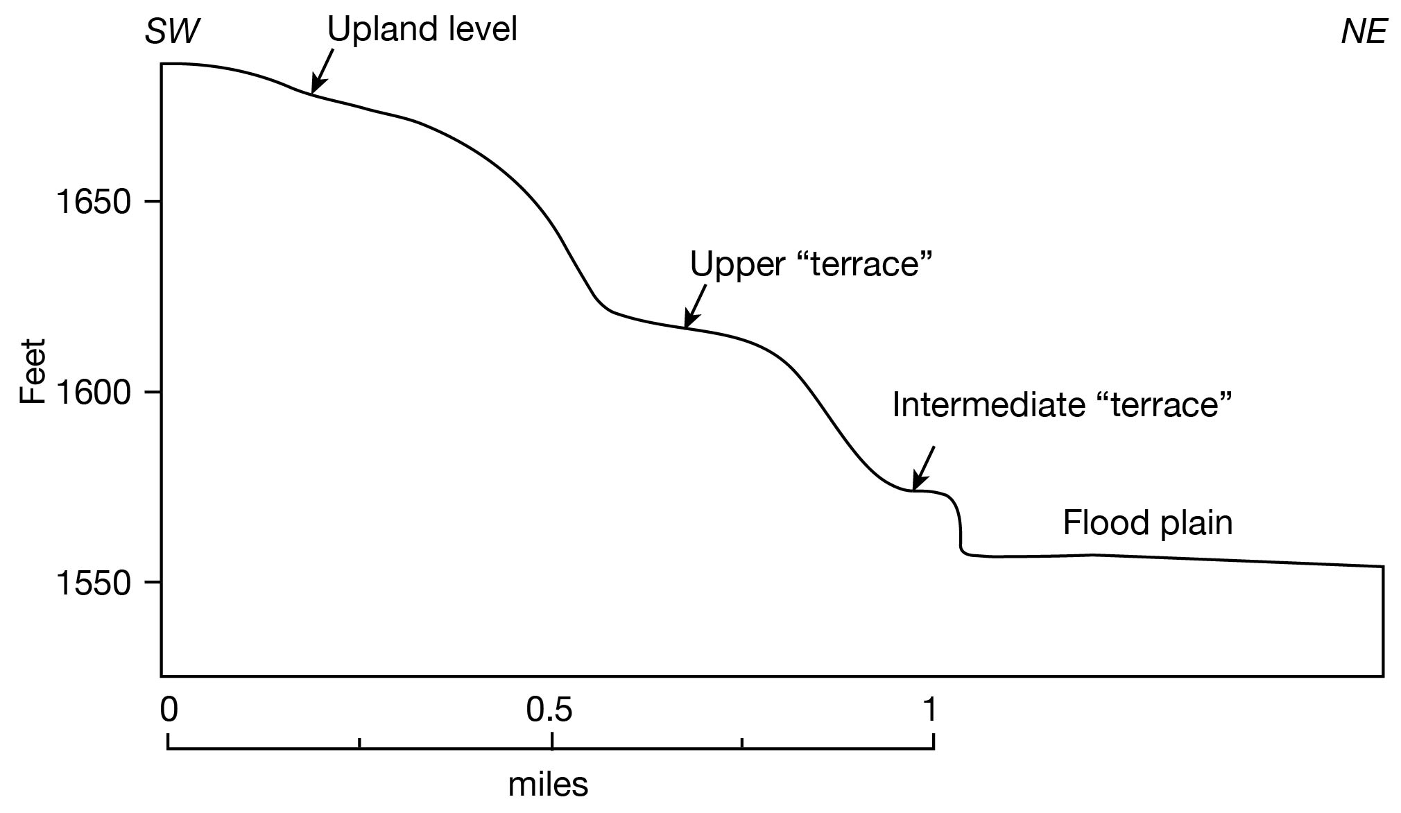
The dissected high terrace in the northeastern part of Jewell County extends from White Rock Creek to Republican River and about 9 miles westward from the eastern county line. This is the area underlain by stream deposits laid down by the ancestral Republican River in Kansan time and has no bedrock outcrop. The south margin of this area has moderate slopes and is moderately dissected. The north margin is deeply dissected and has many "loess canyons." The east-central part of the area is gently sloping, undissected and resembles the surface of an alluvial terrace (Pl. 3C). The western part is indistinguishable from the dissected loess upland to the west. Along the wall of Republican River valley, a narrow strip 0.1 to 0.3 mile wide and 50 to 65 feet above the flood-plain level has a flat "terrace" appearance, but is a flat upland formed by the accumulation of Peoria loess (Pl. 4C). An indistinct intermediate "terrace" about 0.2 mile wide and 15 to 20 feet above the flood-plain level near the SE cor. sec. 5, T. 1 S., R. 6 W. may represent deposits of an alluvial cycle of Kansan to late Wisconsinan age that formed the present alluvial valley. Figure 5 is a profile across the south side of the Republican Valley showing the relationship of the "terraces."
Figure 5--Profile of south wall of Republican River valley from the flood plain in the SE sec. 2, T. 1 S., R. 7 W. to the upland in the SE sec. 10, T. 1 S., R. 7 W.
North of White Rock Creek valley and west from the dissected high terrace area is the dissected loess upland. This area is formed principally by the thick (as much as 150 feet) blanket of eolian silt, or loess, that covers the central part. The loess is thinner on the north and south margins, which are characterized by outcrops of Cretaceous bedrock. In general, the area is rolling and has moderately well-entrenched streams with narrow valleys. The divide area, 1 to 2 miles south of the State line, is a gently rolling to flat upland that grades imperceptibly into the more dissected areas north and south.
The valley of each major creek in Jewell County has a narrow flood plain bordered by low terraces 10 to 20 feet above the floodplain level. The valley of Republican River has a wide flood plain and remnants of low terraces occur only locally. The principal alluvial valley areas are shown in Figure 3 and on Plate 1, and the low terraces are described in the discussion of alluvium in the geology section.
The highest point in the county has an altitude of about 1,960 feet, and is about a mile south of the northwest corner of the county. Dog and Plum creeks leave the southeastern part of the county at an altitude of slightly less than 1,400 feet. The maximum relief, therefore, is about 560 feet.
Jewell County is drained by Republican River and by tributaries of Republican and Solomon rivers. Republican River is the only perennial stream in the county. The principal streams of the county besides Republican River are Brown, Buffalo, Dog, Hermes, Limestone, Marsh, Oak, Plum, and White Rock creeks. White Rock Creek, the most prominent of the small streams, originates in Smith County, flows in an easterly direction across the north-central part of Jewell County, and enters Republican River near Republic in Republic County. White Rock Creek may be classed as a perennial stream, but its flow has ceased during some dry seasons. Prior to 1900 a saw mill on White Rock Creek at Burr Oak was powered by water. In Jewell County all creeks south of White Rock Creek flow southeastward. They are all intermittent. Buffalo Creek originates near Mankato, passes near Jewell City and Randall, and enters Republican River above Concordia in Cloud County. Marsh Creek is a tributary of Buffalo Creek. Tributaries of Limestone Creek originate near Esbon and Eleon, unite south of Ionia, and join Hermes Creek, which enters Solomon River near Glen Elder in Mitchell County. Brown, Dog, Oak, and Plum creeks are small intermittent streams that originate in the southern part of Jewell County and flow southward into Mitchell County where they enter Solomon River.
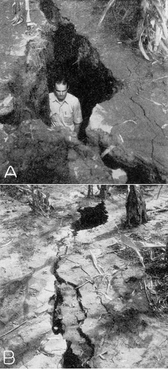
An interesting phenomenon connected with drainage was observed near Jewell City in September 1941. A local 5-inch rain at Jewell City resulted in deep soil cracks in a cornfield in the SE sec. 30, T. 4 S., R. 7 W. (Pl. 5). The soil cracks had a depth in places of more than 7 feet and ranged in width from a few inches to 3 feet. The heavy rainfall occurred at night, and the soil cracks were observed the following morning. The development of the soil cracks has not been explained satisfactorily. The cracks had an outlet into Buffalo Creek and discharged considerable water into the creek. However, there was little surface runoff into the cracks, as shown by a lack of erosion along the top edges. The year 1941 followed a period of about 10 years of low rainfall. The vegetation may have removed much of the moisture in the subsoil causing shrinkage of the subsoil and the formation of large cracks in it. By wetting the upper soil zone the 5-inch rainfall may have lowered its bearing strength and permitted the soil to slip vertically into the crack in the subsoil below. Plate 5 shows some sections in which the upper soil dropped down and other sections in which the soil slumped but did not drop.
Plate 5--Soil cracks in the SE sec. 30, T. 4 S., R. 7 W., after heavy rain on Sept. 18, 1941.
Population
The first attempt to form a settlement in Jewell County was made in the spring of 1862 on land adjoining the now abandoned town of White Rock in the valley of White Rock Creek. A second attempt was made in 1866 about 5 miles west of White Rock. The hostility of some of the Indian tribes prevented a successful settlement until 1869. During 1870 when more than 200 settlers arrived, Jewell County was organized, Jewell City being designated the county seat. Two years later the county seat was moved to Mankato.
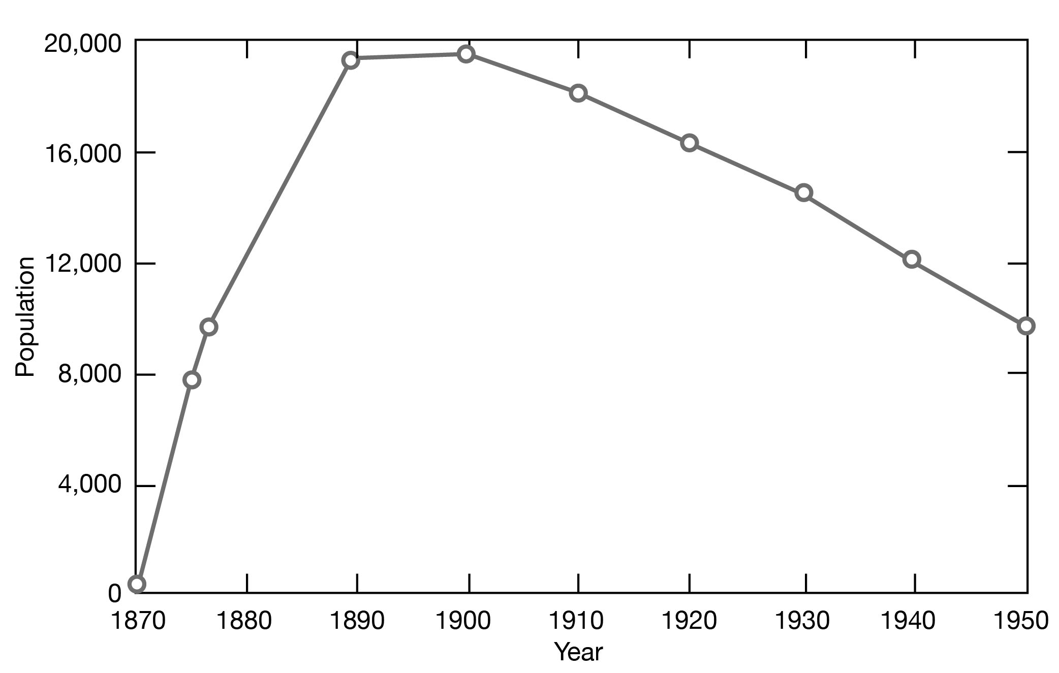
The population of Jewell County in 1870 was 205; in 1875, 7,651; 1877, 9,767; 1890, 19,349; 1900, 19,420; 1910, 18,148; 1920, 16,240; 1930, 14,462; 1940, 11,970, and in 1950, 9,698 (Fig. 6). [Note: Jewell County population was listed as 3,791 in 2000 U.S. census, with a density of 4.2 (32.9 for the state) (KU Institute for Policy & Social Research).] In 1950 the population averaged about 10.5 persons per square mile, only half that of 1900. The chief towns and their respective populations as reported by the census for 1950 are: Mankato, 1,462 [976 in 2000]; Jewell City, 593 [483 in 2000]; Burr Oak, 505 [265 in 2000]; Formoso, 271 [129 in 2000]; Esbon, 278 [148 in 2000]; Randall, 240 [90 in 2000]; and Webber City, 96 [37 in 2000]. Other smaller towns are Dentonia, Ionia, Lovewell, Montrose, North Branch, and Otego.
Figure 6--Population of Jewell County for the period 1870 to 1950.
Transportation
The county is well supplied with facilities for transportation. A main line of the Chicago, Rock Island and Pacific Railway Company traverses the county east-west through the central part and gives direct communication with Denver, Kansas City, and, Omaha. The Missouri Pacific Railway, starting at Burr Oak, passes southeast across the county joining the central branch of this system at Jamestown, a few miles east of the county. The Atchison, Topeka and Santa Fe Railway, entering from the east, passes in a northerly direction across the eastern part of the county to Superior, Nebraska. Superior, which is only a mile north of the county line, is a shipping point of considerable importance having in addition to the Santa Fe, the Chicago and Northwestern, the Missouri Pacific, and the Burlington and Missouri River Railroads. Being on direct lines to Denver, Omaha, Kansas City, and St. Joseph, the county has excellent facilities for marketing crops and livestock.
U. S. Highway 36, paved throughout the county, traverses it east-west through the middle, passing through Formoso, Montrose, and Mankato. Kansas Highway 28 from Concordia through Randall, Jewell City, Mankato, and Burr Oak connects with Nebraska Highway 78. It is paved from the Cloud County line to its intersection with U. S. Highway 36 and graveled from U. S. Highway 36 to the Nebraska State line. Kansas Highway 14 traverses the county north-south through the middle part, extending from Superior, Nebraska, to Beloit, Kansas. It is graveled from Superior to its intersection with U. S. Highway 36 and paved from there to Beloit. Kansas Highway 128, which is graveled, extends from Glen Elder through Ionia to U. S. Highway 36 south of Otego.
Agriculture
Jewell County has a total area of approximately 585,600 acres. In 1950, there were 1,744 farms with a total area of 537,579 acres. There has been a gradual increase in the average size of the farms in Jewell County for many years. The tendency toward an increase in the size of the farms was pointed out by Kocher and others (1914, p. 14), as follows:
In general, it may be said that for the last 40 years there has been a tendency to increase the size of individual farms. According to the census, the percentage of farms operated by owners in 1890 was 70.65, in 1900 it was 62.7. and in 1910, 61.1. According to the same authority, the average size of farms for the last four decades was 163, 166, 169.5, and 183.6 acres, respectively.
According to the 1950 census, the percentage of farms operated by owners was 66.5 and the average size of the farms was 307.4 acres. The number of farms of less than about 400 acres in size is diminishing, and the number of farms that are larger than 400 acres in size is increasing.
Land distribution according to use in Jewell County in 1950 is given in Table 1.
Table 1--Land use in Jewell County in 1950 (1950 census).
| Acres | |
|---|---|
| Crop land harvested | 287,464 |
| Crop failure | 51,062 |
| Crop land idle or fallow | 15,494 |
| Arable pasture | 14,355 |
| Woodland | 14,429 |
| Other uses | 154,775 |
The soils of Jewell County have been formed primarily from the weathering of loess in the northern and northwestern parts of the county, and from the weathering of limestone, sandstone, and shale in the southern part (Throckmorton and others, 1937, p. 103). Sandstone predominated in the parent material only in a small area in the extreme eastern part of the county. The soils in the northern part are gray to yellowish-gray silty loams and silty clay loams that originally were brown in color. The subsoils are yellowish-brown silty clay loams to clay loams. In the southern part of the county, the soils are brown and relatively deep, and the subsoils are brown clay. The soils are not acid and, in general, carry sufficient plant food to meet the requirements of all crop plants. The adapted crops are alfalfa, sweet clover, corn, oats, wheat, and sorghums. The more rolling lands are adapted primarily for the production of grass for grazing purposes.
The principal crops grown in Jewell County and the acreage in 1950 reported by the Kansas State Board of Agriculture (1951) are given in Table 2.
Table 2--Principal crops grown in Jewell County in 1950, including crops not harvested (Kansas State Board of Agriculture, 1951).
| Acres | |
|---|---|
| Wheat | 143,000 |
| Corn | 92,200 |
| Sorghums | 31,900 |
| Barley | 4,400 |
| Oats | 26,000 |
| Alfalfa | 29,550 |
| Rye | 1,200 |
Jewell County has been an important producer of alfalfa. In 1910, about 10 percent of all farm land was in alfalfa. The acreage decreased from approximately 55,000 acres in 1910 to approximately 30,000 acres in 1930 and to 2,813 acres in 1939, then increased to 29,550 acres in 1950. During the years 1911 to 1932, the average yield per acre of wheat was 13.8 bushels and of corn was 17.2 bushels.
In Jewell County livestock production is economically important. In 1950, the livestock in Jewell County was as follows: cattle, 39,500; hogs and pigs, 41,720; and sheep and lambs, 2,500.
Mineral Resources
The mineral resources of economic importance in Jewell County are gravel and sand, limestone, building stone, road material, chalk, ceramic materials, volcanic ash, and lignite.
Sand and gravel deposits are found in the alluvium along Republican River in the northeastern corner of the county. The alluvium is predominantly silt, but many lenses of sand and a few lenses of gravel are included.
The Greenhorn limestone, which crops out extensively in southeastern Jewell County, is used as building stone. The Fencepost limestone bed at the top of the Greenhorn is quarried for use as a building stone. Quarrying is commonly done along the line of outcrop where the overburden is thin and the rock not badly weathered. The bed has a thickness of about 0.8 foot and is moderately fine and chalky in texture. It is soft enough to permit considerable ease in quarrying, but hardens on exposure. The Fort Hays limestone member has been used as construction material for some of the smaller buildings in Jewell County. Tests of this material indicate that it is slightly inferior to the Fencepost limestone for use as structural stone (Byrne, Houston, and Mudge, 1950, p. 20); however, ledges of the Fort Hays are many times thicker than the Fencepost, and much more of the stone is available. Analyses of the chalk of the Fort Hays limestone member in the NW SW sec. 10, T. 2 S., R. 8 W. show the calcium carbonate to range from 90.1 to 97.4 percent (Runnels and Dubins, 1949, p. 33).
Clays suitable for the manufacture of certain ceramic products are found in the Sanborn formation. A study of the ceramic uses of these beds in northern Kansas shows (Frye and others, 1949, pp. 80-83) that the silts and soil zones are the most suitable for the manufacture of brick, tile, and ceramic aggregate. Ceramic aggregate is used for concrete aggregate, road metal, and ballast.
Volcanic ash is found at many places in the Meade formation (Pl. 1). Test data for five samples of ash are given by Byrne, Houston, and Mudge (1950, p. 20, table 1). The occurrence of volcanic ash in Jewell County is discussed by Landes (1928, p. 28).
Lignite has been mined from the Dakota in two and possibly three places in Jewell County (Schoewe, 1952, p. 124). Lignite was mined south of Formoso from some time prior to 1887 to about 1900. Lignite was mined near Jewell City from about 1901 to about 1907. Lignite is not being mined now, but according to Schoewe (1952, p. 128) Jewell County has a reserve of inferred or potential lignite coal of about 22,400,000 tons.
Climate
The climate of Jewell County is typical of the High Plains--hot summers, cold winters, sudden changes of temperature in all seasons, and great variability in precipitation. The spring and fall months are marked by brisk wind movement. The average wind velocity at Concordia in Cloud County is 9.7 miles an hour.
The U. S. Weather Bureau has maintained a precipitation gauge at Burr Oak since 1901. The normal annual precipitation recorded at Burr Oak is 24.56 inches; the normal monthly distribution is given in Table 3.
Table 3--Normal monthly precipitation at Burr Oak.
| Month | Precipitation (inches) |
|---|---|
| January | 0.52 |
| February | 0.93 |
| March | 1.14 |
| April | 2.38 |
| May | 3.54 |
| June | 4.16 |
| July | 2.84 |
| August | 2.99 |
| September | 2.76 |
| October | 1.58 |
| November | 1.03 |
| December | 0.69 |
Approximately 75 percent of the precipitation falls during the 6-month period from April 1 to September 30. The annual precipitation and the cumulative departure from normal precipitation at Burr Oak for the period of record are shown graphically in Figure 7. The precipitation has ranged from 12.38 inches in 1936 to 44.70 inches in 1951. There have been 12 years when the precipitation was less than 20 inches. The cumulative departure from the normal precipitation shows the yearly trend of precipitation. The average precipitation and average departure from normal precipitation, by 10-year periods, from 1901 to 1950 are given in Table 4.
Figure 7--A, Annual precipitation at Burr Oak; B, cumulative departure from normal precipitation at Burr Oak.
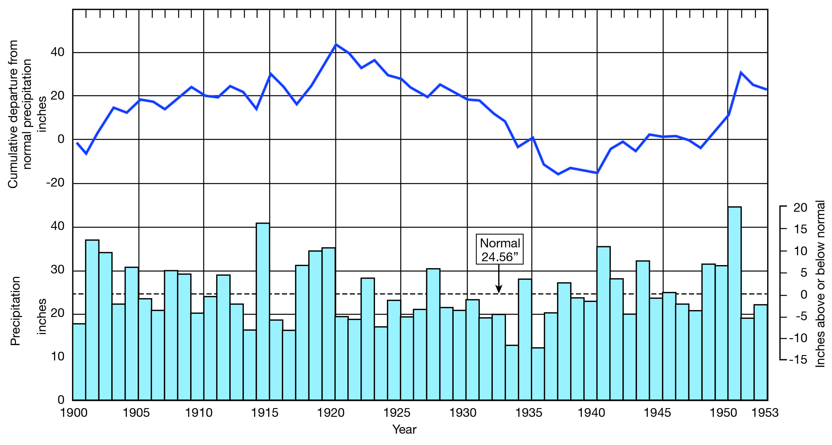
Table 4--Average precipitation and average annual departure from normal precipitation for 10-year periods, 1901-50, at Burr Oak.
| Period | Average precipitation, inches |
Average annual departure from normal, inches |
|---|---|---|
| 1901 to 1910 | 26.60 | +2.04 |
| 1911 to 1920 | 26.95 | +2.39 |
| 1921 to 1930 | 22.08 | -2.48 |
| 1931 to 1940 | 21.09 | -3.47 |
| 1941 to 1950 | 27.17 | +2.61 |
The precipitation averaged below normal from 1921 to 1940. The cumulative excess from 1901 to 1920 was 44.32 inches but the cumulative deficit from 1920 to 1940 was 59.53 inches. In 1941, the precipitation was 11.04 inches above normal and in 1951, it was 20.24 inches above normal.
The mean temperature is about 52.7° F. Since 1930, the temperature has ranged from -23° to + 117° F. The annual maximum, minimum, and mean temperatures and the snowfall for the period 1930 to 1952 are given in Table 5.
Table 5--Maximum, minimum, and mean temperatures and snowfall at Burr Oak for the period 1930-52.
| Year | Maximum temperature, °F |
Minimum temperature, °F |
Mean temperature, °F |
Total snowfall, inches |
|---|---|---|---|---|
| 1930 | 111 | -17 | 53.6 | 11.5 |
| 1931 | 109 | -4 | 55.7 | 16.9 |
| 1932 | 109 | -23 | 51.3 | 37.7 |
| 1933 | 110 | -19 | 55.2 | 6.8 |
| 1934 | 116 | -15 | 56.9 | 15.6 |
| 1935 | 111 | -12 | 56.3 | 4.9 |
| 1936 | 117 | -19 | 53.9 | 9.5 |
| 1937 | 112 | -20 | 52.4 | 15.4 |
| 1938 | 108 | -12 | 55.3 | 4.2 |
| 1939 | 113 | -13 | 55.2 | 23.7 |
| 1940 | 115 | -16 | 52.8 | 45.0 |
| 1941 | 105 | -8 | 54.4 | 32.4 |
| 1942 | 103 | -17 | 51.8 | 17.7 |
| 1943 | 106 | -19 | 52.1 | 13.6 |
| 1944 | 101 | -21 | 51.2 | 30.7 |
| 1945 | 103 | -22 | 50.7 | 35.4 |
| 1946 | 109 | -12 | 53.6 | 3.5 |
| 1947 | 111 | -25 | 51.0 | 22.9 |
| 1948 | 104 | -23 | 50.9 | 46.5 |
| 1949 | 107 | -3 | 51.3 | 16.4 |
| 1950 | 103 | -13 | 50.5 | 8.0 |
| 1951 | 102 | -12 | 50.7 | |
| 1952 | 108 | -7 | 53.6 |
The average length of the growing season is 160 days. The average date of the last killing frost in spring is April 29, and the latest date of a killing frost was May 27. The average date of the first killing frost in the fall is October 6, and the earliest date of a killing frost was September 13.
Prev Page--Introduction || Next Page--Geology
Kansas Geological Survey, Geology
Placed on web Nov. 21, 2008; originally published Oct. 1955.
Comments to webadmin@kgs.ku.edu
The URL for this page is http://www.kgs.ku.edu/General/Geology/Jewell/03_geog.html