![]()
Prev Page--Contents || Next Page--Geography
Introduction
Purpose and Scope of the Investigation
The investigation upon which this report is based is part of an extended program of ground-water investigations in Kansas begun in 1937 by the United States Geological Survey and the State Geological Survey of Kansas, in cooperation with the Division of Sanitation of the Kansas State Board of Health and the Division of Water Resources of the Kansas State Board of Agriculture. Investigations of the ground-water resources in several other counties in Kansas have been made and additional investigations are planned until the area of the entire State has been studied. An observation-well program was started in 1934 in the Limestone Creek basin in Jewell County by the Federal Geological Survey in cooperation with the Soil Conservation Service. Since 1938, this observation-well program has been maintained as a part of the cooperative ground-water program in Kansas.
Jewell County was selected for study because it is typical of many areas where surficial deposits yield water meagerly and where the underlying bedrock yields either no water or highly mineralized water. The investigation in Jewell County also takes advantage of the records of the observation-well program that was begun in 1934.
The investigation was made under the general administration of A. N. Sayre, Chief of the Ground Water Branch of the U. S. Geological Survey.
Location and Extent of the Area
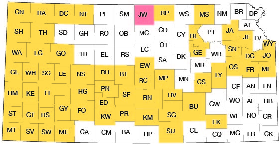
Jewell County lies in the first tier of counties from the northern border of the State and midway between the east and west borders of the State (Fig. 1). The county lies between meridians 97° 56' and 98° 30' west longitude and parallels 39° 34' and 40° 00' north latitude. It has an area of about 915 square miles and extends 30 miles north and south and about 30.5 miles east and west.
Figure 1--Index map of Kansas showing area described in this report and areas covered by other online geologic reports, as of Nov. 2008. For additional information, please visit the KGS Geologic Maps of Kansas Page.
Previous Geologic and Hydrologic Investigations
The more important studies dealing with the geology and ground-water resources of north-central Kansas that have a bearing on Jewell County are cited below. Specific references are cited at appropriate places in the text by author and date and are listed in the references at the end of the report.
The geology of upper Cretaceous rocks in Kansas was described by Logan in 1897. Darton (1905, p. 304) made reference to a few wells in this area in a preliminary report on the geology and ground-water resources of the central Great Plains. Because of the severe drought culminating in 1913 that resulted in water shortages in a large part of the State, Haworth (1913, pp. 40-43) prepared a special report on well waters in Kansas in which he discussed the availability of ground water in the Republican River valley. A report was prepared by Wing in 1930 on the geology of Cloud and Republic Counties. Also in 1930, a report was prepared by Landes on the geology of Mitchell and Osborne counties. The Dakota formation in areas adjacent to Jewell County was described by Tester in 1931. In 1934 the U. S. Geological Survey in cooperation with the Soil Conservation Service started an observation-well program in the Limestone Creek area. The records of the water-level measurements of these wells have been published in the annual series of water-level reports of the U. S. Geological Survey (1936-54, Water Supply Papers 777, 817, 840, 845, 886, 908, 938, 946, 988, 1018, 1025, 1073, 1098, 1128, 1158, 1167, 1193, 1223). In 1940, Moore and others prepared a generalized report on the ground-water resources of Kansas. A study of the outcrop area of the Dakota formation was made by Plummer and Romary (1942). In 1948, Fishel prepared a report on the ground-water resources of Republic and northern Cloud counties which included chapters on the Quaternary geology and Cenozoic geologic history. Construction-materials reports have been prepared for Jewell County (Byrne, Houston, and Mudge, 1950), Smith County (Byrne, Houston, and Mudge, 1948), Mitchell County (Byrne, Johnson, and Bergman, 1951), Cloud County (Buck, Van Horn, and Young, 1951), and Osborne County (Walters and Drake, 1952). In 1952, A. R. Leonard prepared a report on the geology and ground-water resources of the valley of the North Fork Solomon River.
Methods of Investigation
The field work upon which this report is based was started in August 1941. V. C. Fishel worked in the county from August through October 1941; H. A. Waite worked in the county in September and October 1941; and A. R. Leonard worked in the county in September and October 1946.
In making an inventory of 259 wells in the county, the total depths of the wells and the depths to water level below land surface were measured with a steel tape. Well owners and drillers were interviewed regarding the nature and thickness of the water-bearing formations penetrated by the wells, and all available well logs were collected. Records of wells that furnish public, industrial, domestic, and irrigation supplies were collected. Information obtained included the yield, drawdown, temperature of water, chemical character of the water, and the use of ground water. Samples of water collected from 36 representative wells were analyzed by H. A. Stoltenberg, Chemist, in the Water and Sewage Laboratory of the Kansas State Board of Health at Lawrence.
A pumping test on a well at Jewell City was made. The test consisted of pumping a centrally located well at a given rate and observing the decline of the water levels in near-by observation wells. After pumping stopped, the rate of recovery of the water level in the pumped well was observed. The pumping test was made to determine the yield of the well, the rate of movement of the water through the formation, and the cone of depression surrounding the well caused by the removal of the water, as a guide to the effects of future pumping in this and similar localities.
Field data were compiled on topographic maps of the Federal Geological Survey and on a county map from the Kansas Highway Department. Locations of roads were corrected from observations in the field and the drainage was corrected from aerial photographs obtained from the United States Department of Agriculture, Agricultural Adjustment Administration. The areal geology was studied by A. R. Leonard and a geologic map (Pl. 1) was prepared by him.
The locations of all wells for which descriptions are given in the table of well records are shown on Plate 2, with the exception of some wells near Formoso which are shown on Figure 9.
Well-numbering System
The well and test-hole numbers used in this report give the location of wells according to General Land Office surveys and according to the following formula: township, range, section, 160-acre tract within that section, and 40-acre tract within that quarter section. The 160-acre and 40-acre tracts are designated a, b, c, or d, in a counterclockwise direction beginning in the northeast quarter. For example, well 2-10-6aa is located in the NE NE sec. 6, T. 2 S., R. 6 W. (Fig. 2). If two or more wells are within a 40-acre tract, they are numbered serially according to the order in which they are inventoried.
Figure 2--Map of Jewell County illustrating the well-numbering system used in this report.
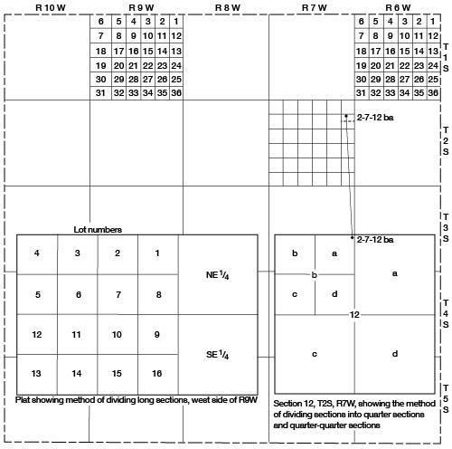
The sections of the west tier of R. 9 W. in Jewell County are about 132 miles wide. Approximately the east third of the section is divided as in normal sections; the remainder of the section is divided into lots as shown in Figure 2. The well number of a well located in one of the lots contains only the township, range, and section. If more than one well is located in that part of the section the wells are numbered consecutively as inventoried.
Acknowledgments
Appreciation is expressed to the many persons who cooperated and assisted in the collection of field data. The water superintendents and other officials of the cities of Burr Oak, Esbon, Formoso, Jewell City, Mankato, and Randall supplied information concerning their municipal wells, the use of water, and other pertinent data. Geologic information was interchanged in the field and in the office with Frank E. Byrne, Max S. Houston, and Melville R. Mudge.
The manuscript of this report has been reviewed critically by several members of the Federal and State Geological Surveys; by Robert V. Smrha, Chief Engineer, and George S. Knapp, Engineer, Division of Water Resources, Kansas State Board of Agriculture; and by Dwight F. Metzler, Chief Engineer, and Willard O. Hilton, Geologist, Division of Sanitation, Kansas State Board of Health,.
Prev Page--Contents || Next Page--Geography
Kansas Geological Survey, Geology
Placed on web Nov. 21, 2008; originally published Oct. 1955.
Comments to webadmin@kgs.ku.edu
The URL for this page is http://www.kgs.ku.edu/General/Geology/Jewell/02_intro.html