![]()
Prev Page--Recovery, Utilization, Chemical character || Next Page--Well Records
Geologic Formations in Relation to Ground Water
Cretaceous System
Gulfian Series
Dakota Formation
Character, distribution, and thickness--The Dakota is the basal unit of the Gulfian series (Moore and others, 1951, p. 25, Figs. 11-12). In north-central Kansas, the Dakota consists of 200 to 300 feet of clay, shale, siltstone, and sandstone locally containing thin lignitic beds in the upper part. Plummer and Romary (1942), who made an intensive study of the Dakota formation in the outcrop area in central Kansas, showed the Dakota to be principally clay and shale containing irregular sandstone lentils, which are interconnected only locally.
In Jewell County the character of the Dakota formation is believed to be similar to that as shown by studies of the outcrop areas in Cloud and Republic counties to the east (Wing, 1930, pp. 31-35; Fishel, 1948, pp. 79-84). In those areas it is composed largely of clay and shale containing sandstone and siltstone beds. The clays are gray, white, yellow, red, maroon, or variegated, are generally plastic, and many contain silt, limonite, or siderite.
The lenticular sandstone beds range from a few inches to many feet in thickness, may be poorly cemented or so well cemented with calcium carbonate that they are quartzitic, and contain limonite, hematite, and siderite. The sandstones range from fine to coarse grained, although fine-grained beds predominate, and may be cross bedded or ripple marked. They are highly lenticular and although present in one locality may be absent a short distance away laterally. Locally, in the upper 30 feet of the formation, lignite beds as much as 3 feet in thickness occur (Schoewe, 1952, pp. 81-87). Lignitic coal was mined from these beds 50 to 60 years ago at two localities in Jewell County (Schoewe, 1952, pp. 124-128).
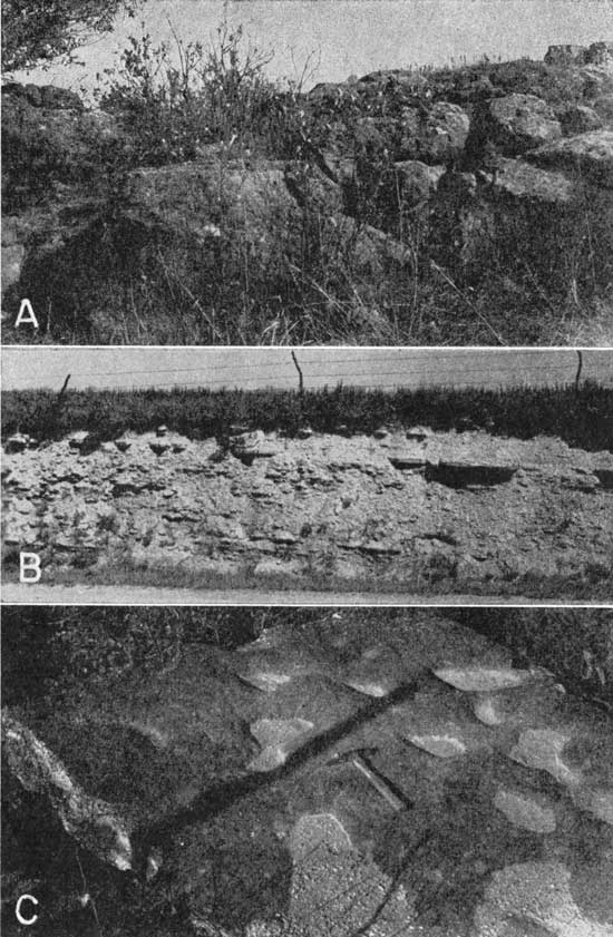
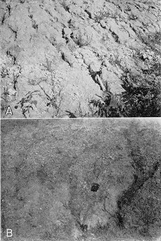
The Dakota formation underlies all Jewell County but crops out in only one small area south of Buffalo Creek in secs. 12, 13, and 14, T. 5 S., R. 6 W. In this area the exposed Dakota formation consists of 11 to 28 feet of massive sandstone, which underlies the Graneros shale, and about 3 feet of gray clay shale (Pl. 7A). The sandstone is fine grained, cross bedded, and loosely cemented with limonite, or, locally, well cemented with calcium carbonate to form ellipsoidal masses of hard resistant "quartzite." The sandstone weathers to a rusty brown and forms a small ledge at the base of the steep slope on the south side of Buffalo Creek valley.
Plate 7--Cretaceous rocks in Jewell County. A, Massive sandstone of the Dakota formation in the NW NW sec. 13, T. 5 S., R. 6 W. B, Lower part of Pfeifer shale member, Greenhorn limestone in road cut in NE SE sec. 12, T. 5 S., R. 7 W. C, Small solution pits developed in upper surface of "Shellrock limestone" bed of Jetmore chalk member, NE sec. 15, T. 5 S., R. 6 W.
Water supply--Although the Dakota formation in this part of Kansas is composed of about 75 percent clay and shale, a well drilled at any spot is likely to penetrate one or more sandstone lentils that are water bearing. Oil and gas tests in Jewell County and wells drilled at Mankato and Jewell for municipal water supplies tapped only salt water in the sandstones of the Dakota formation. Several wells in the south part of T. 5 S., R. 6 W. are the only wells in the county known to obtain potable water from the Dakota formation. Wells 5-6-24cc, 5-6-26ba, and 5-6-34cd are more than 100 feet in depth, and had depths to water levels of 91.25, 17.35, and 98.66 feet respectively in October 1941. Analyses of water from wells 5-6-26ba and 5-6-34cd indicate that water in the Dakota formation in this area is high in mineral content, especially calcium, sodium, bicarbonate, and sulfate. The water is not the predominantly sodium-chloride water expected from reports of "salt water" in deep wells in the county and may represent water that has been mixed with water from other formations.
The origin of the mineralized waters in the Dakota formation has been a problem for half a century. Logan (1897, pp. 209-210) suggested that the minerals might come from saliferous beds in the upper part of the formation. Recent detailed surface work by Plummer and Romary (1942) and subsurface study by Frye and Brazil (1943) have failed to reveal any saliferous beds in the Dakota formation. The mineralized water in the Dakota formation in Jewell County is likely connate marine water that has not been completely flushed out of the sandstones and replaced by fresh water.
The depth to the top of the Dakota formation ranges from a few feet in southeastern Jewell County to more than 600 feet in the northwestern part of the county.
Graneros Shale
Character, distribution, and thickness--The Graneros shale consists of the noncalcareous fissile marine shale and sandstone beds that lie conformably between the Dakota formation and the Greenhorn limestone (Moore and others, 1951, p. 25, Figs. 11-13).
The Graneros shale is black, weathering to lead gray or coffee brown. Locally it contains siltstone or sandstone beds, limonitic zones, and thin fossiliferous limestone beds. Selenite crystals occur in the formation in many places.
The Graneros shale crops out in only one area in Jewell County, but it underlies all parts of the county except in the area where the Dakota formation crops out, and also in Buffalo Creek valley adjacent to the outcrop area of the Dakota formation where the Graneros shale has been removed by erosion. In the outcrop area in the NW 1/2 sec. 14 and sec. 15, T. 5 S., R. 6 W., the Graneros consists of about 15 feet of black noncalcareous fissile shale containing limonitic and sandy layers. A massive bentonite bed, 1.0 to 1.4 feet thick, occurs about 1 foot below the top of the formation. The base of the formation is not exposed in these areas, but the covered slope formed by the Graneros shale can be traced 1 mile northeast of its outcrop, where it is underlain by sandstones of the Dakota formation.
The thickness of the Graneros shale in the subsurface of Jewell County is not known, but it is probably between 20 and 30 feet for most parts of the county. Wing (1930, p. 31) states that the thickness of the formation in Republic and Cloud counties ranges from 20 to 30 feet, and Landes and Ockerman (1930, p. 30) report a thickness of 26 feet near Simpson in southeastern Mitchell County.
Water supply--The Graneros shale is relatively impermeable and no wells are known to obtain water from it in Jewell County.
Greenhorn Limestone
Character, distribution, and thickness--The Greenhorn limestone is the series of marine beds conformably overlying the Graneros shale and conformably underlying the Carlile shale. The Greenhorn limestone has been subdivided into four members, in ascending order: Lincoln limestone member, Hartland shale member, Jetmore chalk member, and Pfeifer shale member (Moore and others, 1951, pp. 24-25, Figs. 11-13). The predominant lithology of the Greenhorn limestone is chalky shale or shaly chalk. Interbedded with the shale are thin limestones, as much as 1 foot in thickness, and thin bentonites, as much as 0.5 foot in thickness. Limestone is most common in the basal part and upper third of the formation; the middle part contains very little limestone. The limestones in the basal part are thin, irregularly bedded to lenticular, hard, dark, and "petroliferous" (that is, they exude an odor of petroleum when freshly broken). The limestones in the upper part commonly range from 0.2 to 0.5 foot in thickness and are soft, chalky, and white to cream colored. Many of them are of uniform thickness over considerable areas, but others, particularly those in the Pfeifer shale member, are lenticular or are zones of flat discoidal concretions.
The principal outcrop areas of the Greenhorn limestone in Jewell County are south of Buffalo Creek valley in the southeastern part of the county and along Marsh Creek in the east part of T. 4 S., R. 6 W. The Greenhorn limestone forms a series of prominent rolling hills on the south sides of the two streams, but on the north sides of the valleys the outcrop is obscured by loess of the Sanborn formation and the limestone crops out only where deeply dissected. Except for small areas along Marsh and Buffalo creeks where it has been removed by erosion, the Greenhorn limestone underlies all of Jewell County. Landes (1930, p. 23) gives the thickness of the Greenhorn limestone in Mitchell County as 82 feet. Measured sections of the Pfeifer shale member and Jetmore chalk member near Randall indicate that the thickness of the formation in that area is about the same as in Mitchell County. The formation thins rapidly toward the east, and the total thickness near the Cloud County line is only about 65 feet. Along the eastern border of Jewell County, in secs. 24, 25, and 36, T. 5 S., R. 6 W., the upper member, the Pfeifer shale member, has been eroded away and the hills are capped by the Jetmore chalk member. Locally in this area, the upper bed of the Jetmore chalk member, the "Shell-rock limestone," has been quarried for fence posts.
The basal member of the Greenhorn limestone, the Lincoln limestone member, overlies the Graneros shale and crops out in a small area in the southeastern part of Jewell County. In the outcrop area the Lincoln limestone member is about 15 feet thick and is composed principally of gray to cream-colored calcareous shale. Thin limestones commonly ranging from 0.5 to 1 inch in thickness occur irregularly in the lower part. They are generally hard, dark, and coarsely crystalline and contain fragments of fossil shells and shark teeth. On weathering they become brown and finely laminated. Many are "petroliferous" (give off a petroleum odor when freshly broken). The upper part of the Lincoln limestone member contains several limestone beds of the same type but ranging from 2 to 4 inches in thickness. Several beds of cream-colored to orange bentonite are present in the Lincoln member.
The Hartland shale member of the Greenhorn limestone crops out in about the same general area as the Lincoln limestone member. The Hartland shale member consists of about 25 feet of calcareous shale containing thin lenticular slabby limestones and many bentonite beds ranging from a featheredge to 6 inches in thickness. The shale is generally slaty in fresh exposures but becomes fissile and buff colored as it weathers. Some of the limestones are crystalline and resemble those of the Lincoln limestone member, but the limestones in the upper part of the member are soft and almost chalky in appearance.
The Jetmore chalk member crops out in most of the outcrop area of the Greenhorn limestone shown on Plate 1. The member contains several limestones in the upper part that are resistant to erosion and form the capping strata for the prominent Greenhorn hills in the southeastern part of the county. The topmost bed of the Jetmore chalk member is the "Shell-rock limestone". The bed, about 1 foot thick, has a thin shale parting in the center which contains many Inoceramus shells. Locally, where this limestone caps bills and ledges, small irregular pits may develop in the upper surface (Pl. 7C). This bed and three thinner underlying persistent limestones are the resistant strata that form the Greenhorn escarpment. The Jetmore chalk member consists of shale beds ranging from 0.5 to 1.0 foot in thickness alternating with beds of fossiliferous chalky limestone ranging from 0.2 to 0.5 foot in thickness. The shale is calcareous, slaty, and blue gray in fresh exposures but becomes fissile and cream colored as it weathers. The Jetmore chalk member in Jewell County ranges in thickness from about 10 feet in the SE sec. 29, T. 5 S., R. 6 W., to about 16.7 feet in the SW sec. 35, T. 3 S., R. 6 W. The thickness is probably 16 to 17 feet in the subsurface beneath most of Jewell County. A typical measured section of the Jetmore chalk member is given below.
The uppermost member of the Greenhorn limestone, the Pfeifer shale member, consists principally of calcareous chalky shale, thin lenticular limestone, and zones of flat discoidal concretions (Pl. 7B). The Fencepost limestone bed, a persistent chalky limestone about 0.8 foot thick at the top of the member, has been quarried at several places in southeastern Jewell County for building stone and for stone fence posts. This bed, the thickest persistent limestone in the Pfeifer shale member, is easily recognized by its thickness and a thin iron-stained band in the center. A second limestone bed, about 4.5 feet lower, is sometimes mistaken for the Fencepost. This limestone is only about 0.3 to 0.4 foot thick and lacks the prominent iron-stained band. Other limestone beds in the member are generally 1 to 4 inches thick, chalky, and lenticular or irregularly bedded, and contain Inoceramus shells. The concretionary zones are 1 to 2 inches thick and are generally formed by bands of discoidal concretions which are as much as 1 foot in diameter. The concretions are somewhat harder than the chalky limestones and also contain Inoceramus shells. The shale is calcareous, fissile, and generally white to cream colored in most exposures. Two or three thin bentonite seams occur in the member at some localities. The measured section below illustrates the lithology of the Pfeifer shale member and Jetmore chalk member.
| Measured section of the Greenhorn limestone, in the east cut bank of a creek just west of north-south road in the NW SW sec. 35, T. 3 S., R. 6 W. Measured by H. A. Waite, October 2, 1941. | Thickness, feet |
|||
|---|---|---|---|---|
| Cretaceous--Gulfian | ||||
| Greenhorn limestone | ||||
| Pfeifer shale member | ||||
| 44. Limestone, dense, fine-grained; fencepost limestone bed; contains characteristic reddish-brown seam near middle | 0.75 | |||
| 43. Shale, chalky; contains gray bentonitic clay seam 3/4 inch thick at base | 0.6 | |||
| 42. Shale, calcareous, buff to orange-tan | 2.8 | |||
| 41. Limestone, similar to bed 39 | 0.2 | |||
| 40. Shale, calcareous, fissile, light-buff streaked with brown laminae | 0.9 | |||
| 39. Limestone, dense, fine-grained, buff to brown, rusty stained | 0.3 | |||
| 38. Shale, calcareous, buff to orange-tan; contains several thin beds of fossiliferous slabby limestone | 2.5 | |||
| 37. Limestone, fine-grained, buff to yellow | 0.25 | |||
| 36. Shale, calcareous, gray to buff | 0.5 | |||
| 35. Limestone, fine-grained, gray to buff | 0.2 | |||
| 34. Shale, calcareous, platy, gray to buff | 1.0 | |||
| 33. Limestone, fine-grained, gray to buff, rusty-brown near base | 0.2 | |||
| 32. Shale, calcareous, fissile | 1.7 | |||
| 31. Limestone, fine-grained, buff | 0.15 | |||
| 30. Shale, calcareous, gray to buff | 0.5 | |||
| 29. Limestone, fine-grained, buff | 0.15 | |||
| 28. Shale, calcareous, fossiliferous, gray to buff | 2.2 | |||
| Jetmore chalk member | ||||
| 27. Limestone, fine-grained, dense, very fossiliferous, ligbt-buff; sell-rock limestone | 0.9 | |||
| 26. Shale, calcareous, light-gray to buff; contains several thin limestone beds | 2.0 | |||
| 25. Limestone, fine-grained, fossiliferous, gray to cream | 0.4 | |||
| 24. Shale, calcareous, platy, gray to buff | 0.8 | |||
| 23. Limestone, dense, gray; contains small brown fossil impressions (Inoceramus) | 0.3 | |||
| 22. Shale, calcareous, fossiliferous, gray to buff | 0.7 | |||
| 21. Limestone, dense, fine-grained, fossiliferous, cream-colored to gray | 0.3 | |||
| 20. Shale, platy; gray at top, gray to orange-tan at base | 0.5 | |||
| 19. Limestone, fine-grained, gray to buff | 0.25 | |||
| 18. Shale, calcareous, gray | 0.5 | |||
| 17. Limestone, fine-grained, gray to buff | 0.25 | |||
| 16. Shale, calcareous, light-gray | 0.4 | |||
| 15. Limestone, fine-grained, cream-colored to buff stained with rusty-brown splotches | 0.25 | |||
| 14. Shale, calcareous, fissile, light-gray with rusty-brown streaks; contains 2-inch limestone 3 inches above base | 1.0 | |||
| 13. Limestone, fine-grained, dense, cream-colored to light-yellow; contains rather persistent rusty-brown band 1 inch thick near middle | 0.5 | |||
| 12. Shale, calcareous, fissile, light-gray with rusty-brown laminae | 0.4 | |||
| 11. Limestone, fine-grained, gray to bluish-gray | 0.2 | |||
| 10. Shale, calcareous, fissile, light-gray to bluish-black | 0.75 | |||
| 9. Limestone, fossiliferous, bluish-gray to tan | 0.3 | |||
| 8. Shale, calcareous, fissile, orange-tan at top, bluish-gray in lower part; contains fossils | 0.4 | |||
| 7. Limestone, fine-grained, gray with rusty streaks | 0.2 | |||
| 6. Shale, calcareous, platy, bluish-gray | 0.4 | |||
| 5. Limestone, fine-grained; contains rusty streaks | 0.3 | |||
| 4. Clay, bentonitic, bluish-gray mottled with yellow | 0.2 | |||
| 3. Shale, calcareous, platy, bluish-gray | 3.5 | |||
| 2. Clay, bentonitic, gray; contains limonitic streaks | 0.5 | |||
| 1. Limestone, dense, gray, limonite-stained near top | 0.4 | |||
| Base of section, water level in creek | ||||
| Total thickness of Greenhorn exposed | 31.5 | |||
Water Supply--In general, the predominance of shale in the Greenhorn limestone indicates that the formation has little potential as an aquifer. Elsewhere, small quantities of water have been obtained from wells penetrating the weathered and broken limestones in the upper part of the formation, but no wells in Jewell County are known to obtain water from the Greenhorn. A small spring in NW the NW sec. 13, T. 5 S., R. 6 W. flows from the basal beds of the Greenhorn. The water is reported to be of good quality and is stored in a small pond for livestock use.
Carlile Shale
Character, distribution, and thickness--The Carlile shale consists of 300 feet of marine shale conformably overlying the Greenhorn limestone and conformably underlying the Niobrara formation (Moore and others, 1951, p. 24, Figs. 11-13). The lower part, the Fairport chalky shale member, consists predominantly of thin-bedded to fissile calcareous shale containing an abundance of Ostrea shells. On fresh exposures the shale is light gray to buff, but it weathers to form a bright-yellow clay that is distinctive and easy to recognize. The basal part of the Fairport chalky shale member contains several persistent bentonite seams, many thin chalky limestones, and concretionary beds similar to those in the upper part of the Greenhorn limestone. The limestones are generally white, buff, or pink, and seem to persist over some distance. The thickness of the Fairport member is about 100 to 110 feet. The following section illustrates the lithology of the member in Jewell County.
| Measured section of lower part of Fairport chalky shale member of Carlile shale in SW SE sec. 9, T. 5 S., R. 7 W. Measured by A. R. Leonard, October 1946. | Thickness, feet |
||
|---|---|---|---|
| Cretaceous--Gulfian | |||
| Carlile shale--Fairport chalky shale member | |||
| 8. Covered slope to top of knoll | |||
| 7. Shale, fissile, calcareous, gray and white, weathers bright yellow. Contains Ostrea shells, sandy streak near center | 12.0 | ||
| 6. Limestone, fine-grained, pink, somewhat concretionary; contains pyritic zone in center | 0.4 | ||
| 5. Shale, fissile, calcareous; gray, white, and buff, weathers yellow-buff; contains Ostrea shells | 7.6 | ||
| 4. Limestone, concretionary in lower part; contains shale parting in upper part | 0.4 | ||
| 3. Bentonite, gray and orange mottled | 0.3 | ||
| 2. Shale, calcareous, white to gray; contains chalky concretionary limestones at 0.6 and 2.2 feet above base | 3.7 | ||
| 1. "Fencepost limestone" bed, of Greenhorn limestone exposed at creek level | |||
| Total exposed Carlile shale | 24.4 | ||
The upper 200 feet of the Carlile shale, the Blue Hill shale member, consists principally of fissile noncalcareous black to blue-gray marine shale. The Blue Hill shale member is well exposed in many places below the prominent escarpment of the Fort Hays limestone member of the Niobrara formation, and smaller exposures occur along many of the stream banks in the outcrop area (Pl. 1, 9B). Many zones of septarian concretions, containing cross-cutting veins of brown calcite that weather in relief, are present in the upper part of the Blue Hill shale member (Pl. 8B). The concretions are spherical, discoidal, or lemon-shaped and in Jewell County have a maximum diameter of about 4 feet. Gypsum, generally in the form of selenite crystals, occurs in thin lenticular bands in the upper part of the member. Zones of thin discoidal concretions containing ammonite, gastropod, and Inoceramus shells occur in the lower part of the member. In southwestern Osborne and northern Ellis counties several feet of sandstone and sandy shale in the uppermost part of the Blue Hill shale member make up the Codell sandstone zone. In Jewell County, the Codell sandstone zone is represented by about 6 to 15 inches of friable fine-grained limonitic sandstone at the top of the Blue Hill member. Locally, fossil shark teeth are present in the Codell sandstone zone.
Water Supply--The shales of the Carlile shale are impervious and do not yield water to wells in Jewell County. The Codell sandstone zone is too thin and contains too much fine-grained material to serve as an aquifer in this area.
Plate 8--A, Loess on Niobrara formation in east bank of creek in NE sec. 7, T. 2 S., R. 9 W. B, Septarian concretion in the Blue Hill shale member of the Carlile shale near the NW cor. sec. 8, T. 5 S., R. 10 W.
Niobrara Formation
Character, distribution, and thickness--The Niobrara formation, the uppermost Cretaceous unit in Jewell County, conformably overlies the Blue Hill shale member of the Carlile shale and in the western part of Kansas is overlain conformably by the Pierre shale (Moore and Landes, 1937; Moore and others, 1951, pp. 22-24, Fig. 11). The total thickness of the Niobrara formation in north-central Kansas is about 650 feet (Landes and Keroher, 1942, p. 286), but only the lower 300 to 400 feet is exposed in Jewell County. The basal part of the Niobrara formation, the Fort Hays limestone member, forms a prominent escarpment trending irregularly northeastward from the southwestern part of the county toward Lovewell in the northeastern part. Northwestward from this escarpment the Niobrara formation is well exposed, the best exposures being along the divide and valley wall south of White Rock Creek. North of White Rock Creek the Niobrara formation is buried, except locally, by Pleistocene deposits.
Plate 9--A, Looking northeast at Fort Hays limestone member of the Niobrara formation in SW SW sec. 33, T. 3 S., R. 9 W. B, Contact of the Fort Hays limestone member and the Carlile shale in the east bank of creek near the middle of sec. 33, T. 1 S., R. 3 W.
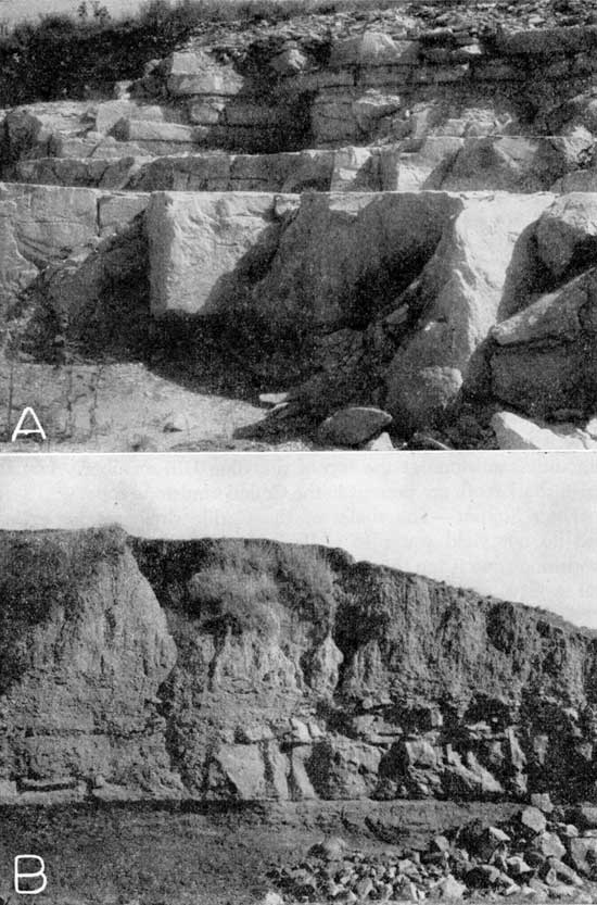
The Fort Hays limestone member consists of 30 to 45 feet of soft, massive white chalk beds ranging from 1 to 5 feet in thickness separated by thin shale or bentonite partings (Pl. 9A). The chalk beds contain large Inoceramus grandis and small Ostrea congesta shells. Small concretions of pyrite and limonite as much as an inch in diameter are in the chalk, and small particles of pyrite are disseminated widely through the chalk in some places. The Fort Hays limestone member has been quarried at many places along the outcrop for building stone and for road metal. It is quarried in sec. 5, T. 1 S., R. 7 W. as a source of lime for cement manufacture and is transported to the Nebraska Cement Company's plant at Superior, Nebraska, for processing. The section below illustrates the character of the Fort Hays limestone member.
| Section of the Fort Hays limestone member of the Niobrara formation measured in the W. P. A. quarry in the SE cor. sec. 29, T. 3 S., R. 7 W., about 5 miles east and 2 miles south of Mankato, Kansas. Measured by H. A. Waite, September 17, 1941. | Thickness, feet |
||
|---|---|---|---|
| Cretaceous--Gulfian | |||
| 11. Covered slope; contains hard white thin-bedded slabby zone near base (weathered Fort Hays member) | |||
| Niobrara formation--Fort Hays limestone member | |||
| 10. Limestone, chalky, hard, yellow; weathers white | 0.5 | ||
| 9. Limestone, similar to bed 10 | 0.4 | ||
| 8. Limestone, dense, hard, yellow | 1.8 | ||
| 7. Limestone, similar to bed 8 | 2.7 | ||
| 6. Limestone, hard, cream-colored to white; contains very small Ostrea | 0.9 | ||
| 5. Limestone, chalky, hard, massive, cream-colored to yellow; contains large Inoceramus shells, some specimens 5 inches in longest dimension | 3.1 | ||
| 4. Limestone, chalky, massive, yellow | 1.5 | ||
| 3. Limestone, chalky, massive, yellow; contains harder fossiliferous slab at top; speckled with small ironstone concretions, both nodules and root-like stems; contains Inoceramus shells some specimens 6 1/2 inches in diameter | 4.5 | ||
| Carlile shale-Blue Hill shale member | |||
| 2. Sandstone, argillaceous, very fine, rusty-brown (Codell sandstone zone) | 1.0 | ||
| 1. Shale, platy, bluish-gray | |||
| Total thickness of Fort Hays limestone member exposed | 15.05 | ||
The Smoky Hill chalk member overlies the Fort Hays limestone member and is the upper unit of the Niobrara formation. Only the lower half, 300 to 350 feet, of the Smoky Hill chalk member is present in Jewell County, the upper part having been removed by erosion. The member consists principally of thin-bedded to fissile shaly chalk or chalky shale beds that are blue gray in fresh exposures but weather to yellowish buff, yellow, orange, or white. Locally, the member contains thin bentonite seams and beds of massive chalk as much as 1 foot in thickness, similar to the chalk in the Fort Hays limestone member. Inoceramus and Ostrea shells are common and concretions of limonite and pyrite are present. The Smoky Hill chalk member has been eroded to form rounded promontories and parabolic hills that are well exposed south of White Rock Creek in the southern part of T. 2 S., Rs. 7, 8, and 9 W. Near Burr Oak long colluvial slopes developed on the Smoky Hill chalk member extend from the drainage divide a few miles south of White Rock Creek to the low terraces bordering the stream. These slopes are examples of the "flanking pediments" described by Frye and Leonard (1952, pp. 25-28) and are underlain by a few inches to a few feet of colluvial debris and soil (Pl. 4B). The following section illustrates the lithology of the Smoky Hill chalk member.
| Partial section of the Smoky Hill chalk member of the Niobrara formation near the NE cor. SE sec. 33, T. 2 S., R. 8 W., about 2 1/2 miles north of Mankato, Kansas. Measured by H. A. Waite, September 24, 1941. The top 13 feet of the section was measured and described from an exposure in the road cut on the east side of the north-south section road, at a point directly across from the cut bank on the east side of a small creek where the bottom part of the measured section is exposed. | Thickness, feet |
||
|---|---|---|---|
| Cretaceous--Gulfian | |||
| Niobrara formation--Smoky Hill chalk member | |||
| 20. Clay, yellow (covered slope) | 2.0 | ||
| 19. Shale, chalky, fissile, cream-colored | 7.5 | ||
| 18. Gypsum seam, persistent, deep rusty-brown, crystalline gypsum predominating; contains thin seam of yellow weathered bentonite | 0.1 | ||
| 17. Shale, chalky, soft, fissile, cream-colored | 1.8 | ||
| (Section continued in east bank of creek near the Cen. E. line of sec. 33, T. 2 S., R. 8 W., about 150 feet west of road cut described above.) | |||
| 16. Chalk, cream-colored | 2.0 | ||
| 15. Shale, chalky, soft, fissile, bluish-gray | 11.2 | ||
| 14. Chalk, soft, bluish-gray | 5.0 | ||
| 13. Chalk, soft, bluish-gray; contains horizontal stringers of calcite | 4.3 | ||
| 12. Bentonite, thin seams; not very well developed | 0.02 | ||
| 11. Shale, chalky, soft, bluish-gray | 1.6 | ||
| 10. Chalk, soft, bluish-gray | 1.2 | ||
| 9. Shale, chalky, bluish-gray | 0.9 | ||
| 8. Bentonite | 0.02 | ||
| 7. Shale, chalky, bluish-gray | 1.2 | ||
| 6. Bentonite, brown; very thin seam | 0.02 | ||
| 5. Limestone, chalky; contains persistent 1/4-inch black streak near middle | 0.7 | ||
| 4. Shale, chalky, bluish-gray | 0.3 | ||
| 3. Bentonite, brown, split seam | 0.06 | ||
| 2. Chalk, soft, bluish-gray | 2.1 | ||
| 1. Shale, chalky, fissile, bluish-gray | 3.0 | ||
| Base of section, dry bed of creek | |||
| Total section measured | 45 | ||
Water Supply--In general, the chalk and chalky shale of the Niobrara formation are impervious and do not yield water to wells. Some wells may obtain small quantities of water from the formation where it is jointed and fractured. Large fractures filled with secondary calcite indicate that some water has circulated through the formation in the past. In most localities, however, the fractured part of the Niobrara formation is in the topographically higher parts of the area above the water table.
Quaternary System
Pleistocene Series
Unconsolidated deposits of Quaternary age are the near-surface materials over a very large part of the area shown on the geologic map (Pl. 1), and they are the only important water-bearing rocks in the area. The entire Quaternary System is represented by the Pleistocene Series, of which the Recent Stage is the uppermost subdivision. The Pleistocene deposits in Jewell County range in age from Kansan (Meade formation) to Recent (alluvium) and include: Meade formation, undifferentiated limestone gravel, Sanborn formation, terrace deposits, and alluvium. Each is unconformable on the Cretaceous bedrock units or on older Pleistocene rocks. All the Pleistocene rocks are continental in origin and were deposited principally by flowing streams or by wind, although some rocks probably were formed by colluvial processes that moved them only a short distance and modified them only slightly.
Wind-deposited silts of the Sanborn formation have been recognized and mapped in all parts of the county. Recognition was based principally on distinctive lithology that has been used as a criteria for recognition elsewhere in north-central Kansas (Frye and Leonard, 1949; Leonard, 1952). In general,an attempt was made to map the Sanborn formation wherever it was at least 4 or 5 feet in thickness. In some places where the thickness of the Sanborn was greater than 5 feet, however, it was not mapped because it was desired to show other features such as the escarpment of the Fort Hays limestone member or small shale exposures. Along the south side of White Rock Creek thin loess and colluvium of the Sanborn formation, which may be thicker than 5 feet and overlie the Smoky Hill chalk member, were not mapped so that the flanking pediments developed on the Smoky Hill chalk member could be emphasized. Deposits of the Meade formation were mapped on the basis of the lithologically distinctive Pearlette volcanic ash lentil, on fossil evidence, and on the relation of the deposits to the younger Sanborn formation. In northeastern Jewell County the Meade formation includes sand and gravel deposits previously classed as the Belleville formation (Wing, 1930; Lohman, Fishel, 1948). The areas mapped as Meade formation on Plate 1 are those areas where it was recognized as such. In other areas, silt of the Meade formation, which is not readily distinguishable from the Sanborn formation, has been mapped with the Sanborn formation. Limestone gravel, probably equivalent in age to the Meade formation, at many places overlying Cretaceous bedrock and underlying silt of the Sanborn formation, has been mapped with the Sanborn formation. In other places the limestone gravel may represent deposits of Nebraskan age older than the Meade formation.
Meade Formation
Classification and correlation--The Meade formation includes the continental deposits, principally stream-laid, formed during the late Kansan and Yarmouthian Stages. The formation consists of a lower sand and gravel unit, the Grand Island member, and an upper fine-grained unit, the Sappa member, which consists of silt, fine sand, clay, and, locally, volcanic ash (Pl. 10A). Both members are present in Jewell County, although the Sappa member is much more widely distributed.
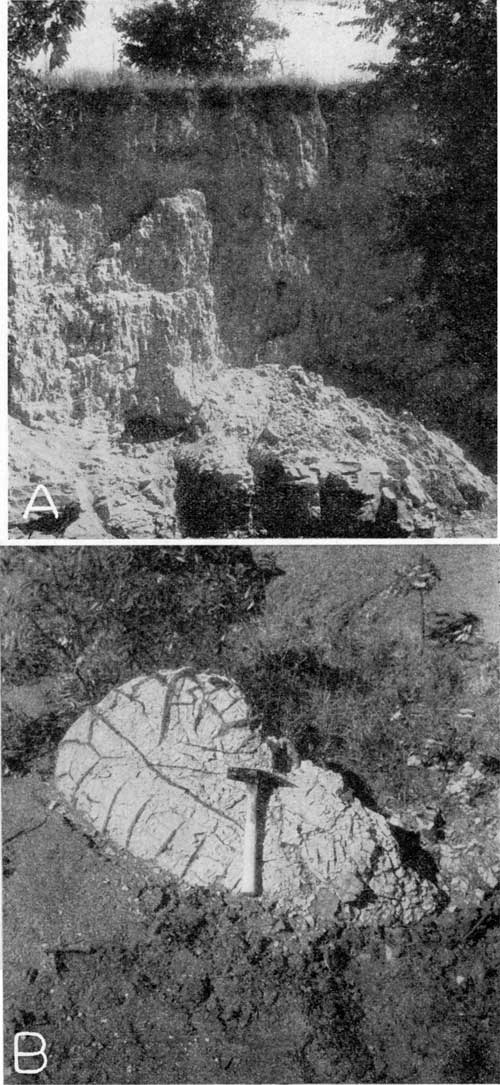
Plate 10--Meade formation. A, Volcanic ash in Sappa member of the Meade formation; in the NE NW sec. 16, T. 1 S., R. 6 W. B, Cross-bedded sand and gravel of Grand Island member, Meade formation in gravel pit in the NE sec. 11, T. 1 S., R. 6 W.
The "Meade gravels" were named by Cragin (1896, p. 54) from exposures in central Meade County. Later, Frye and Hibbard (1941, p. 411) redefined the Meade formation to include all the beds of Pleistocene age between the top of the Rexroad deposits and the base of the Kingsdown silt. In 1948, Frye, Swineford, and Leonard (pp. 501-525) used the Pearlette volcanic ash and molluscan faunas in deposits associated with the ash to correlate deposits of late Kansan and Yarmouthian ages from the Plains region to the glaciated region. They proposed that the name Meade be applied to sediments formed during the Kansan cycle of alluviation and adopted the member classification used in this report.
In northeastern Jewell County, the Meade formation includes sand and gravel deposits continuous with those in Republic County formerly assigned to the "Belleville" formation (Wing, 1930, pp. 19-21; Lohman, Fishel, 1948, pp. 89-93). Wing assigned the Belleville to the middle Pliocene on the basis of Trilophon teeth found in a sand and gravel pit northwest of Belleville. Lugn (1935, p. 196) objected to the Tertiary classification of these deposits and to the name "Belleville." Although he published no faunal lists nor cited any specific locations, he stated: "Equus and other Pleistocene mammalian remains have been gotten from the same deposits at the same locations described by Mr. Wing." He stated his belief that these deposits were continuous with the Grand Island formation in Nebraska and suggested that name for them.
Lohman (Fishel, 1948, pp. 89-92) agreed with Lugn that these deposits were of Pleistocene age and cited the occurrence of teeth of Stegomastodon and Equus cf. excelsus Leidy in the gravels in Republic County as further evidence of the early Pleistocene age of these deposits. He redefined the "Belleville formation" to include the stream-deposited sand and gravel underlying the loess in northern Republic County, Kansas, and assigned it to the Pleistocene. Lohman suggested that the "Belleville formation" might include deposits equivalent to the Holdrege formation in Nebraska in addition to sand and gravel deposits equivalent to the Grand Island formation of Nebraska.
In northeastern Jewell County, the deposits classed as Grand Island member of the Meade formation, which are a westward extension of the stream-deposited sand and gravel classed as "Belleville" in Republic County are, in their upper part at least, clearly of Kansan and Yarmouthian age. They are conformably overlain by a thin section of silt and sandy silt that contains lenses of Pearlette volcanic ash. Sand and gravel deposits in the deeper part of the filled channel may, as Lohman suggested, be equivalent to older deposits. This part of the section does not crop out at the surface and is not separated by any persistent fine-grained bed from the sand and gravel in the upper part of the channel fill. In this report all the deposits filling the bedrock channel are assigned to the Meade formation.
In northwestern Jewell County, the Pearlette volcanic ash lentil at many places directly overlies Cretaceous bedrock or is only a few feet above the top of the bedrock. Water wells in that area have reported volcanic ash at depths of 90 to 115 feet beneath the surface and just above bedrock. The lower Grand Island member is absent or very thin, and the Meade consists predominantly of the upper fine-grained part, the Sappa member. In the SW SE sec. 13, T. 2 S., R. 10 W., a fossil soil of Yarmouthian age marks the top of the Sappa member of the Meade formation and is unconformably overlain by silts of the Sanborn formation (Pl. 11B). The following section was measured on the east side of a small draw just north of a section-line road at that locality.
| Section of the Sappa member, Meade formation, and Sanborn formation in the SW SE sec. 13, T. 2 S., R. 10 W., on east side of a small draw just north of section-line road. | Thickness, feet |
||
|---|---|---|---|
| Quaternary--Pleistocene | |||
| Sanborn formation--Loveland silt member | |||
| 3. Silt, massive, structureless, reddish-buff; lower 5 feet contains many large nodules of calcium carbonate | 12.5 | ||
| Meade formation--Sappa member | |||
| 2. Silt (Yarmouth soil), dark-gray; exhibits soil structure; contains some calcium carbonate | 1.5 | ||
| 1. Silt, friable, massive, grayish-white; small sandy zone containing fossil mollusks about 1 foot below top. To bottom of small gully | 4.0 | ||
| Total Pleistocene section exposed | 18.0 | ||
Fossil mollusks from sandy silt about 232 feet below top of Sappa member, Meade formation, SW SE sec. 13, T. 2 S., R. 10 W., Jewell County have been identified by A. Byron Leonard as follows.
| Gastrocopta armifera | Pupilla blandi |
| Succina grosvenori | Pupilla muscorum |
| Helisoma anceps | Vallonia gracilicosta |
| Valvata tricarinata | Helicodiscus parallelus |
| Sphaerium sp. | Hawaiia minuscula |
| Strobilops sparsicosta | Pisidium pyramidatum |
| Discus cronkhitei | Gyraulus labiatus |
| Physa anatina | Zonitoides arboreus |
| Ferrissia parallela |
Dr. A. Byron Leonard (personal communication dated June 8, 1948) stated concerning the fossil mollusks contained in bed 1 in the above section:
This is a mixed fauna, terrestrial and aquatic, and is, in my judgment, a fauna that is quite characteristic of the Sappa [member of the Meade formation].
Plate 11--A, Friable massive silt in Sappa member (Meade formation) showing nodules of calcium carbonate; NW SW sec. 29, T. 1 S., R. 9 W. B, Humic zone in upper part of Yarmouth soil zone at top of Sappa member (Meade formation) overlain by Loveland silt member (Sanborn formation) containing nodules of calcium carbonate; SW SE sec. 13, T. 2 S., R. 10 W.
Character, distribution, and thickness--In Jewell County the Meade formation contains deposits of a widely divergent lithology, from fine massive silt to coarse cross-bedded sand and gravel. The lower member, the Grand Island, consists of cross-bedded coarse sand and gravel of the Rocky Mountain type probably derived from the Ogallala formation to the west (Pl. 10B). Interbedded with the sand and gravel are lenses of sandy silt and green gritty clay. Locally, the sand and gravel are stained rusty brown by iron oxide. In the outcrop area a few miles northwest of Mankato (Pl. 1) some of the finer sand in the basal part of the Grand Island member is cemented with calcium carbonate to form a white "mortar bed," similar to the "mortar beds" described in the Ogallala formation (Frye and Leonard, 1949, p. 37). Near Mankato the Meade deposits fill a narrow channel cut into the Smoky Hill chalk member of the Niobrara formation and the calcium carbonate cement may have been derived by solution from the chalk beds.
The thickness of the Grand Island member is as much as 120 feet as penetrated in test hole 1-6-19aa. Along the bluff on the south side of the Republican River in the northeast part of T. 1 S., R. 6 W., 30 to 40 feet of sand and gravel is exposed and overlies the Blue Hill shale member of the Carlile shale. In the area between Republican River and White Rock Creek in northeastern Jewell County, the Grand Island member ranges from 20 to 120 feet and averages 30 to 40 feet in thickness in most of the area. In the SW sec. 33, T. 1 S., R. 9 W., the Grand Island member is represented by about 3 feet of fine to coarse sand lying between the Niobrara bedrock and the overlying Pearlette volcanic ash. About 6 feet of greenish quartz sand containing gravel of granitic origin is exposed in a gravel pit in the SW SW sec. 16, T. 3 S., R. 8 W.
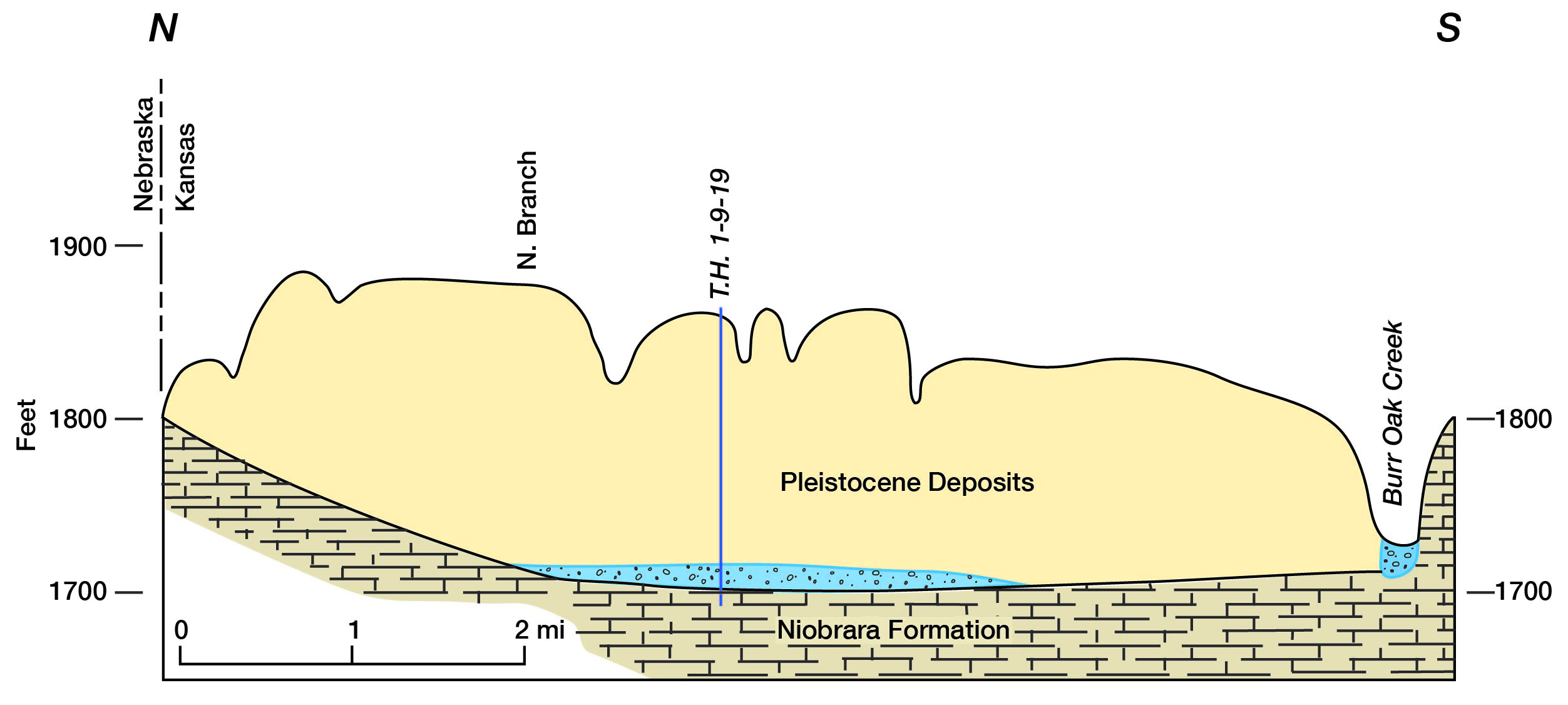
The most prominent outcrops of the Grand Island member are south of Republican River and east of Highway 14, in northeastern Jewell County. Although it does not crop out on the north side of White Rock Creek, the member probably underlies most of the area between White Rock Creek and Republican River in R. 6 W. and the eastern half of R. 7 W. (see cross section, Pl. 1). In that area the Meade formation, principally the Grand Island member overlain by thin deposits of silt of the Sappa member, fills a deep channel cut in the Cretaceous bedrock by the ancestral Republican River. This ancient channel entered Kansas about 5 or 6 miles west of the northeastern corner of Jewell County, trended toward the southeast, and passed eastward into Republic County about 5 miles south of the northeastern corner of Jewell County (Lohman, Fishel, 1948, p. 29). In this area the Meade deposits fill the channel and are spread out over an area several miles wide on the sides of the channel. In part of the area the surface is plane and gently sloping, resembling the undissected surface of a stream terrace (Pl. 3C). In northwestern Jewell County, thin deposits assigned to the Grand Island member occupy the lower part of a broad east-trending valley eroded in bedrock (Fig. 23). Scattered outcrops in the area northwest of Mankato suggest that the member underlies several square miles in that area and probably fills a channel cut into the bedrock by an ancient north-flowing stream.
Figure 23--Filled Pleistocene valley in northern Jewell County.
The Sappa member consists of light-gray to reddish-buff and gray-green stratified silt and fine sand, and volcanic ash. In the northeastern part of the county the Sappa member consists principally of white and buff silt containing lenses of volcanic ash and conformably overlying sand and gravel of the Grand Island member. In northwestern Jewell County, the Sappa member consists principally of light reddish-buff silt, which is massive and friable and contains nodules of concretionary calcium carbonate as much as 3 inches in diameter (Pl. 11A). The following section of the Sappa was measured in a road cut in the NW SW sec. 29, T. 1 S., R. 9 W.
| Section of the Sappa member of the Meade formation in a road cut in the NW SW sec. 29, T. 1 S., R. 9 W. | Thickness, feet |
||
|---|---|---|---|
| Quaternary--Pleistocene | |||
| Meade formation--Sappa member | |||
| 6. Silt, limy, grayish-tan; contains nodules of calcium carbonate up to 3 inches in diameter. To top of road cut | 11.0 | ||
| 5. Large calcium carbonate concretions | 1.0 | ||
| 4. Silt, buff; contains streaks and a few nodules of lime | 2.2 | ||
| 3. Silt, limy, lenticular, tan; weathers to form a crumby-textured surface; contains nodules of lime | 0-1.3 | ||
| 2. Silt, limy, friable, flaky, calcareous, white; upper part nodular | 1.2 | ||
| 1. Silt, somewhat limy, gray-tan; contains some nodules of calcium carbonate; basal 2 feet poorly exposed; to base of cut | 7.5 | ||
| Total Pleistocene section exposed | 24.2 | ||
The fine-grained, massive character, lack of stratification, and upland position of this material suggest that, in this area, it may have been deposited as eolian silt derived from the flood plain of the ancestral Republican River to the north and northeast and carried southward by the wind in the same manner that the Peoria silt was formed at a later time. The large calcium carbonate nodules were formed secondarily during the period of soil formation subsequent to the deposition of this silt, and the reddish color also is probably the product of soil-forming processes.
The thickness of the Sappa member of the Meade formation is difficult to determine over most of Jewell County because it resembles the overlying Loveland silt member of the Sanborn formation. Test holt 1-6-20aa penetrated 27 feet of silt containing caliche and fine sand, all of which is topographically lower than a near-by bed of volcanic ash. The entire silt section in this test-hole is judged to be assignable to the Sappa member. About 20 to 25 feet of silt of the Sappa member is exposed in many road cuts in northwestern Jewell County, and the thickness of the member is probably 20 to 50 feet over most of that area.
Thin deposits of fine-grained material of the Sappa member of the Meade formation probably lie beneath the younger loess and over the Grand Island member in northeastern Jewell County. The Sappa member probably makes up most of the fill of the broad bedrock valley that extends eastward from northwestern Jewell County between White Rock Creek and the north edge of the county. Many outcrops of volcanic ash in the southwestern part of T. 1 S., R. 9 W. and in the northwestern part of T. 2 S., R. 9 W. are in the lower part of the member and, locally, lie directly on Cretaceous bedrock. Other outcrops of volcanic ash in the SE sec. 11, T. 3 S., R. 8 W. and in the SE sec. 20, T. 5 S., R. 9 W. indicate the presence of scattered remnants of deposits of the Sappa member in the southern part of the county. No extensive areas of the Sappa member are known in the southern part of the county, where the Sappa is probably thin and discontinuous.
Water supply--In the filled-channel area in northeastern Jewell County, moderate supplies of ground water suitable for domestic and stock use can be obtained from the Grand Island member of the Meade formation in most places. In this area ground water in the Meade formation is under water-table conditions and the water table is continuous with the water table in northwestern Republic County. In northwestern Republic County ground water moves generally eastward and toward Republican River (Fishel, 1948, Pl. 8), and movement of ground water in northeastern Jewell County is probably in the same direction. The deep dissection of the land surface by Republican River and its tributaries has cut through the entire thickness of the Meade formation in secs. 11 and 12, T. 1 S., R. 6 W., allowing ground water to be discharged into surface streams. In general, the saturated material in the Meade formation in this area ranges from 20 to 45 feet in thickness (cross section, Pl. 1) and probably averages 25 feet. Locally, the bedrock extends above the water table so that no saturated material would be penetrated by a well drilled at that spot.
In northwestern Jewell County, ground water is under water-table conditions in the Sappa member of the Meade formation in the broad filled valley north of White Rock Creek. In this area many wells are reported to supply water adequate for domestic and stock needs. Movement of ground-water in these deposits is probably eastward toward the area of Meade deposits in the northeastern part of the county and southeastward toward the valley of White Rock Creek.
Small supplies of ground water adequate for domestic and stock wells for several farms in sec. 32, T. 2 S., R. 8 W. and secs. 5 and 6, T. 3 S., R. 8 W. are obtained from wells in the Meade formation. Well 3-8-6cd was a community well during the drought period of 1934 to 1938.
Except in the northeastern part of Jewell County, the saturated material in the Meade formation is generally too fine grained to yield large supplies of water to wells. In the northeastern part of the county, the saturated material is not thick enough to support wells of large yield. Therefore, only moderate supplies of ground water can be obtained from the Meade formation in Jewell County.
Undifferentiated Limestone Gravel
Character, distribution, and thickness--One of the most widespread lithologic types in Jewell County is the limestone gravel deposits that are present in all parts of the county but are most common in the areas southeastward from the escarpment of the Fort Hays limestone member of the Niobrara formation. In most exposures the gravel consists principally of subangular to subrounded waterworn limestone pebbles commonly from 0.5 to 1 inch in diameter. In many localities the pebbles are derived almost entirely from the Fort Hays limestone member of the Niobrara formation, but in places in northern Jewell County they are derived from limestone beds in the Smoky Hill chalk member, and locally in southern Jewell County they contain limestone fragments from the Fairport chalky shale member of the Carlile shale or fragments of septarian concretions from the Blue Hill shale member. Intermixed with the limestone pebbles are fragments of shale from the Carlile shale, silt, and clay locally in the form of "clay-balls" as much as 6 inches in diameter. In most exposures the limestone gravel lies directly on the Carlile shale and is overlain by silt of the Sanborn formation. For this reason and because its age could not be determined, the gravel was mapped with the Sanborn formation.
The thickness of the limestone gravel, except where it underlies alluvial terraces or alluvial valleys, is probably 10 feet or less, although 14 feet is exposed in the Dietz quarry in the NW sec. 7, T. 5 S., R. 9 W. The principal area of occurrence is the Jewell plain (Pl. 3B), that broad plain between the escarpments of the Fort Hays limestone member and the Greenhorn limestone. In this area, the Carlile shale bedrock lies at a relatively shallow depth and is overlain by a few feet of limestone gravel and weathered shale, and the surface is formed by silt of the Sanborn formation. Locally along some of the streams, the thin surficial deposits have been eroded away and shale bedrock is exposed.
Age relations--No fossils have been found associated with the limestone gravel, so that its age is in question. It seems to be clearly Pleistocene in age because of its position below the general upland level on which the Pliocene Ogallala formation was deposited a few miles to the west. At many places, it underlies the Loveland and Peoria silt members of the Sanborn formation so that it is probably Illinoian or older in age. In a road ditch in the SW sec. 20, T. 1 S., R. 9 W., limestone gravel was observed underlying the Pearlette volcanic ash lentil and a gray-buff silt. At this locality the gravel is older than the ash and may belong to the Grand Island member of the Meade formation.
Probably the limestone gravel is of different ages in different localities in Jewell County, ranging from Nebraskan to Wisconsinan.
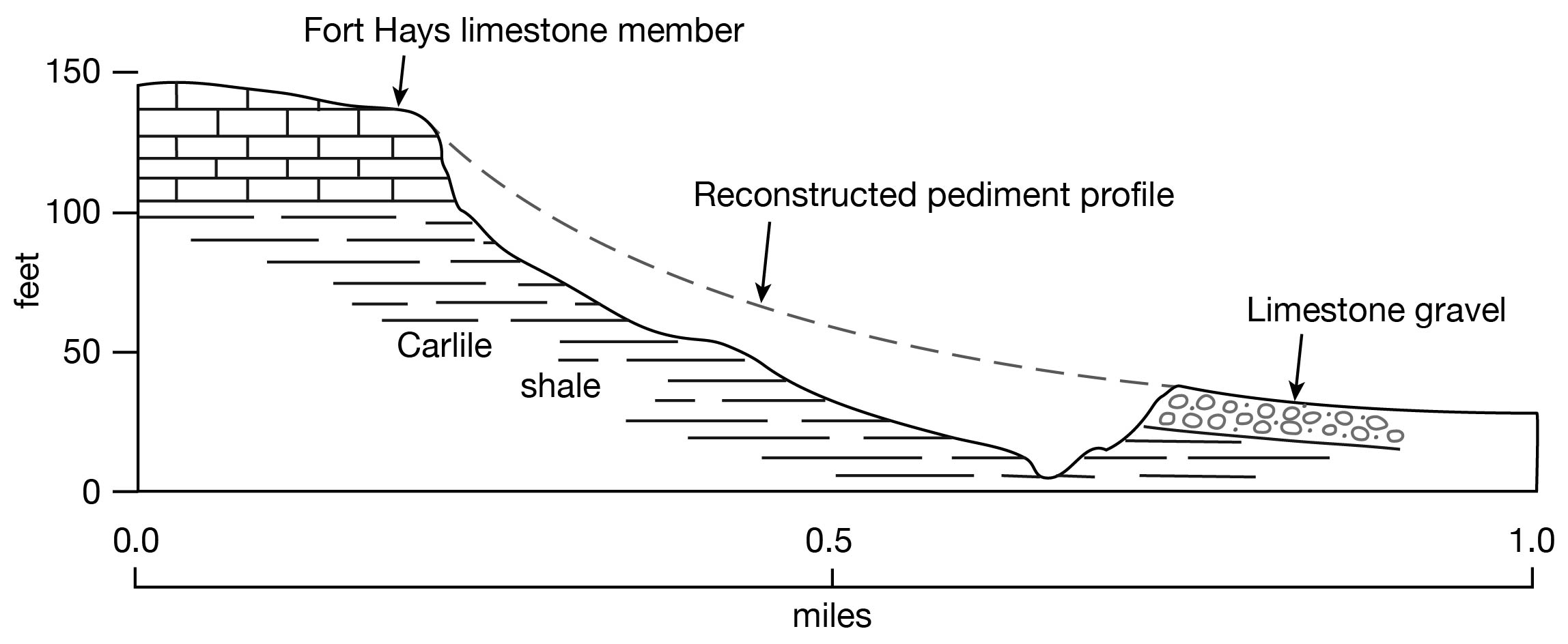
Origin--Most of the limestone gravel deposits probably were formed by small streams that rounded and abraded weathered limestone from the Niobrara formation and spread it irregularly along their valleys. As the streams shifted their courses, limestone gravel was deposited in the new valleys until a large area was underlain by the gravel. Some of the gravel, however, may have originated as colluvial deposits. "Ramps" or "flanking pediments" probably of colluvial origin extend out from some of the elongated spurs of the Fort Hays limestone member and in places completely mask the underlying Carlile shale. In other places the "flanking pediments" have been eroded adjacent to the limestone escarpment, creating a second smaller escarpment about half a mile away where limestone gravel caps a small bluff of Carlile shale facing the limestone bluff (Fig. 24). In these localities the limestone gravel probably is largely of colluvial origin. Good examples of these eroded pediments can be seen in secs. 1 and 14, T. 5 S., R. 10 W., and sec. 14, T. 4 S., R. 9 W.
Figure 24--Cross section showing the origin of limestone gravel escarpments.
Water supply--Limestone gravel is one of the most important aquifers in Jewell County, not because it contains large quantities of water, but because it contains the only ground water available for domestic and stock use over a very wide area. In the Jewell plain, many wells obtain small to moderate supplies of water from wells 10 to 30 feet in depth. The ground water probably occurs as a series of water bodies perched on the Carlile shale rather than as a single continuous water table. Movement of ground water is probably southward and southeastward principally along the alluvial deposits associated with the streams. Locally, seeps or springs occur where erosion has cut through the limestone gravel and exposed the underlying shale.
Sanborn Formation
Classification and subdivisions--The Sanborn formation includes surficial deposits, principally loess and stream deposits, of late Pleistocene age, from Illinoian to late Wisconsinan. It is divided into four members, in ascending order: Crete sand and gravel member (late Illinoian age), Loveland silt member (late Illinoian and Sangamonian age), Peoria silt member (Iowan age), and Bignell silt member (late Wisconsinan age). All members are present in Jewell County,
Character, distribution, and thickness--The Sanborn formation is the most extensive deposit in Jewell County, comprising more than 80 percent of the land surface. Most of the surficial deposits of the formation are fine wind-deposited silt, but other lithologic types include sand and gravel, stratified silt and clay, limestone gravel, and fossil soil zones.
The Crete sand and gravel member of the Sanborn formation forms a high terrace locally along White Rock Creek and is well exposed in a road cut in the NE SE sec. 5, T. 2 S., R. 7 W. At this locality, about 20 feet of quartz and granitic-type gravel containing pebbles from the Cretaceous rocks is overlain by reddish sandy silt of the Loveland silt member. The base of the Crete sand and gravel member is not exposed and the thickness of the member could not be determined.
No deposits of the Crete sand and gravel member are known along Republican River in Jewell County, but subsurface exploration might reveal some deposits beneath the thick loess section adjacent to the river. Limestone gravel underlying the surfaces of high terraces along Limestone and Buffalo creeks is probably equivalent to the Crete sand and gravel member, but it is not well enough exposed any place to relate it to other Pleistocene deposits.
The Loveland silt member of the Sanborn formation consists of reddish-buff silt, sandy silt, and locally stratified silt. Throughout most of the county, particularly the upland areas and the Jewell plain, the Loveland silt member is loess deposited by eolian activity. Locally, on the high terraces, the member may consist of stream-deposited silt formed in the later stages of the alluvial cycle that produced the underlying Crete sand and gravel member.
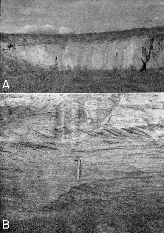
The top of the Loveland silt member is marked by a well-developed fossil soil zone, the Sangamon soil (Pl. 12A, 12B). In its characteristic development the soil zone is 2.5 to 3 feet thick, contains organic matter, and is a dark chocolate brown. The lower part of the soil profile contains an accumulation of clay, is red in color, and locally forms a slight bench on hillsides. The red color, a weathering or soil-forming product, generally extends all through the member. Calcium carbonate has accumulated in the form of small "caliche" nodules below the soil profile, and larger nodules as much as an inch in diameter are seen in the lower part of the member (Pl. 11B).
Plate 12--Pleistocene soils in Jewell County. A, Dark zone of Sangamon soil forming band across plowed field in SW sec. 2, T. 2 S., R. 9 W. B, Sangamon soil resting directly on beveled surface of Fort Hays limestone member and overlain by loess of the Peoria silt member in road cut in SW SE sec. 4, T. 1 S., R. 7 W. C, Brady (?) soil in cut bank of high terrace along small stream in NW NE sec. 4, T. 4 S., R. 9.W.
The following section measured in a gullied field in the NE sec. 33, T. 3 S., R. 8 W., illustrates the character of the Sanborn formation in the upland area in Jewell County.
| Section measured in a gullied field in the NE sec. 33, T. 3 S., R. 8 W.; illustrates the character of the Sanborn formation in the upland area of Jewell County. | Thickness, feet |
|||
|---|---|---|---|---|
| Quaternary--Pleistocene | ||||
| Sanborn formation | ||||
| Peoria silt member | ||||
| 3. Silt, friable, light-gray; contains small nodules of calcium carbonate | 5.0 | |||
| Loveland silt member | ||||
| 2. Soil (Sangamon), compact, dark-brown; lower part chocolate-brown to red clay | 4.0 | |||
| 1. Silt, compact, plastic, clayey, reddish-brown; contains snail shells and calcium carbonate nodules throughout, fine to coarse quartz sand in middle and lower parts, and chalk pebbles in base. To base of gully | 9.0 | |||
| Total Pleistocene section exposed | 18.0 | |||
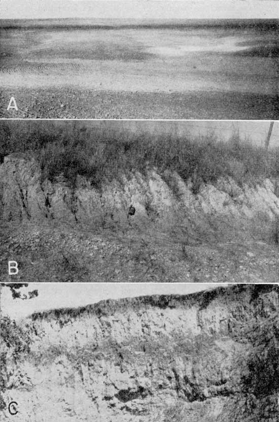
The Loveland silt member ranges in thickness from only a few feet in some of the upland areas to possibly 100 feet in the northern part of the county. In most of southern Jewell County the Loveland silt member is 5 to 10 feet thick. Locally the member is represented by 2 or 3 feet of silt forming a fossil soil resting directly on the eroded surface of Cretaceous rocks. Plate 12B shows the fossil Sangamon soil resting directly on the beveled surface of the Fort Hays limestone member of the Niobrara formation in a road cut in the SE SW sec. 4, T. 1 S., R. 7 W. Similar areas where the bedrock was the Smoky Hill chalk member of the Niobrara formation (Pl. 8A) and the Carlile shale have been observed.
Test hole 1-8-19aa penetrated 148 feet of silt, a large part of which may be the Loveland silt member. In many places in that area the Peoria silt member is thin and the fossil Sangamon soil is only a few feet below the tops of the hills. Probably at least 120 feet of the silt section penetrated by this test hole is assignable to the Loveland silt member of the Sanborn formation and the Sappa member of the Meade formation. The Sappa member is probably less than 50 feet thick and the thickness of the Loveland must be at least 70 feet and may be nearly 100 feet.
The Peoria silt member overlies the Loveland silt member and directly underlies the land surface over much of the upland area and much of the Jewell plain area. The Peoria member consists of soft, friable, calcareous, light yellowish-gray silt containing many shells of small terrestrial snails. It forms a generally unbroken blanket over much of the upland, draping across the escarpment formed by the Fort Hays limestone member and extending out over the "flanking pediments" and the broad plain below the escarpment. In dissected upland areas it caps the higher hills and is well exposed in road cuts, gullied fields, and steep hillsides. The Peoria silt member forms a prominent 75-foot bluff on the south side of Republican River in northeastern Jewell County and attains its greatest thickness in that area (Pl. 4C). The bluff is composed of friable coarse silt of the Peoria silt member. The member thins rapidly away from the river, however, and is probably about 20 feet thick over most of the upland area in the northern part of the county. Over the uplands south of White Rock Creek where the bedrock is the Niobrara formation, the thickness is 5 to 15 feet and probably averages less than 10 feet. Over the Jewell plain area in southern Jewell County the thickness is commonly 5 to 10 feet and averages about 8 feet.
The following section measured in the NW SE sec. 25, T. 3 S., R. 8 W. illustrates the character and thickness of the Peoria and Loveland silt members near the edge of the escarpment of the Fort Hays limestone member.
| Section of the Peoria and Loveland silt members of the Sanborn formation near the edge of the Fort Hays limestone member; measured in the NW SE see. 25, T. 3 S., R. 8 W. | Thickness, feet |
|||
|---|---|---|---|---|
| Quaternary--Pleistocene | ||||
| Sanborn formation | ||||
| Peoria silt member | ||||
| 4. Silt, friable, gray; contains calcium carbonate nodules; thicker on lower part of slope, average | 6.0 | |||
| Loveland silt member | ||||
| 3. Soil (Sangamon), clayey, dark-brown; thins toward top of hill and follows contour of hill | 3.5 | |||
| 2. Silt and clayey silt, reddish-brown; contains chalk fragments and sand; thickens down slope, average | 3.0 | |||
| Cretaceous--Gulfian | ||||
| Niobrara formation | ||||
| Fort Hays limestone member | ||||
| 1. Limestone, chalky, weathered and broken | ||||
| Total Pleistocene section measured | 12.5 | |||
The upper member of the Sanborn formation, the Bignell silt member, has been noted at only a few localities adjacent to Republican River in northeastern Jewell County. In that area it consists of as much as 5 feet of light-gray silt overlying a thin, poorly developed soil zone, probably the Brady soil. The Bignell silt member is absent from the upland areas in northern and central Jewell County and has not been observed in the Jewell plain area in the southern part of the county. Locally along some of the major streams fossil soils that may be equivalent to the Brady soil are overlain by several feet of silt that may represent the Bignell silt member (Pl. 12C). The following section was measured in a stream bank in the NW NE sec. 4, T. 4 S., R. 9 W.
| Section of the Sanborn formation measured in a stream bank in the NW NE sec. 4, T. 4 S., R. 9 W. | Thickness, feet |
|||
|---|---|---|---|---|
| Quaternary--Pleistocene | ||||
| Sanborn formation | ||||
| Bignell silt member (?) | ||||
| 5. Silt, friable, gray-tan; upper 1 foot in modern soil profile | 6.0 | |||
| Peoria silt member | ||||
| 4. Silt [Brady soil (?)], humic, clayey, dark; lower part blocky and clay-like; base and top irregular and indistinct | 4.0 | |||
| 3. Silt, gray-tan; contains snail shells and limestone pebbles; upper contact gradational into soil zone | 2.0 | |||
| 2. Silt, clay, and stringers of limestone pebbles; stratified; contains snail shells; lower part blocky and composed principally of limestone pebbles | 4.5 | |||
| 1. Silt, stratified, tan; contains fine sand and calcium carbonate nodules; lower 7 feet partly covered. To base of stream bed | 11.0 | |||
| Total Pleistocene section measured | 27.5 | |||
Water supply--In the upland areas where the deposits of the Sanborn formation are thin and dissected and overlie Cretaceous bedrock, they are not saturated and are not a source of water. Under the extensive area of the Jewell plain, the water table in the limestone gravels may extend upward into the silt of the overlying Sanborn formation. In those areas wells might obtain meager quantities of water from the Sanborn formation. Small quantities of water may be obtained from the Crete sand and gravel member of the Sanborn formation where the member underlies intermediate terraces along White Rock, Buffalo, and Limestone creeks. In places along those streams the base of the Crete sand and gravel member is probably above the local water table and the deposits are dry. In northwestern Jewell County, the water table in the silts of the Sappa.member may extend upward into the Loveland silt member, or the principal saturated material may be in the Loveland silt member of the Sanborn formation. In that area, moderate quantities of water adequate for domestic and stock use on farms are obtained locally from these fine-grained deposits.
Alluvium
Character, distribution, and thickness--Alluvial deposits of Recent and late Wisconsinan age are present along all the main streams and their principal tributaries in Jewell County. Several of the major streams--Republican River, White Rock Creek, Limestone Creek, and Buffalo Creek--have well-defined low terraces (Pl. 3A) adjacent to their flood plains, but it was not feasible in this report to map these terraces separately from the alluvium of the flood plain. The general character of the terrace deposits and Recent alluvium is very similar and they are discussed together.
Except in Republican River valley, the terrace and flood-plain surfaces along the major valleys are underlain by stratified silt deposited by the streams occupying the valleys. Cut banks as much as 15 feet deep in the flood-plains and as much as 25 feet deep adjacent to the terrace surfaces indicate that the principal material in the upper part of the alluvial fills is silt containing sand and irregular thin lenses of gravel, principally limestone pebbles. As in other valleys in north-central Kansas, the lower part of the alluvial fill is probably composed of sand and gravel, or mixed sand, silt, and gravel. Several wells in White Rock Creek valley are reported to obtain water from "gravel and clay," probably a mixture of gravel, limestone pebbles, and fine silt. White Rock Creek heads in an area of outcrop of the Ogallala formation, so that quartz, granitic, and other igneous-type sand and gravel fragments are available to the stream and may be included in the gravel in the lower part of the alluvium. Limestone, Buffalo, and Marsh creeks head in the area of Cretaceous outcrops in central Jewell County. The coarser material in the alluvium of these valleys is probably composed primarily of rock fragments derived from Cretaceous rocks, principally limestone. Exposures indicate that the upper part of the alluvial material along these streams is principally silt, which contains sand and limestone pebbles. The lower part of the fill is probably similar but may contain a higher proportion of sand and gravel.
The depths of the municipal wells and other wells in White Rock Creek valley reported to penetrate the entire thickness of alluvium indicate that the alluvium ranges in thickness from 50 feet in western Jewell County to about 75 feet in the area of the Mankato well field in sec. 11, T. 2 S., R. 8 W. The level of the low terrace becomes nearer the flood-plain level downstream from the well-field area, and the thickness of the alluvium may decrease in that direction. The thickness of alluvium in Limestone Creek valley is probably as much as 50 feet at the southern edge of the county and probably averages about 40 feet in the area south of Ionia. Upstream from Ionia the thickness of alluvium probably decreases until it is only a few feet in the head-water areas of Limestone Creek. The thickness of alluvium in Buffalo Creek valley is probably between 40 and 50 feet in the area downstream from Jewell City, but it may decrease somewhat east of Randall where the gradient of the stream is flattened as the valley crosses the resistant Greenhorn limestone. The thickness of alluvium in Marsh Creek valley may be less than in the other major valleys, perhaps not more than 30 feet. Marsh Creek valley does not have the well-developed terrace as do the other creek valleys, and the local marshy areas along the valley suggest that shale bedrock may be within a few feet of the surface.
The alluvium underlying the valley of Republican River consists principally of quartz and granitic sand and gravel containing silt in the upper part. The flood-plain surface is very irregular, and locally dunes 5 to 10 feet high have formed on it. At the Superior, Nebraska, well field in sec. 2, T. 1 S., R. 7 W., the thickness of alluvium averages about 32 feet. Beneath the low terrace along the valley margins, the thickness is probably about 40 feet.
Low terraces--All the major streams in Jewell County have low terraces along them, although along some streams the terraces are discontinuous. Republican River valley is 1.5 to 2.5 miles in width in northeastern Jewell County, and the greatest part of the valley is occupied by the sandy irregular flood plain. Low terraces are present only locally, as in secs. 4, 5, 6, and 12, T. 1 S., R. 6 W., and range from 0.25 to 0.75 mile in width. The surface of this terrace is about 10 feet above the general level of the flood plain, is more level than the flood plain, and is generally underlain by silty material.
Most of the area along White Rock Creek shown on the geologic map as alluvium is a low terrace, the surface of which is 15 to 20 feet above the flood-plain level except in the area east of Lovewell where it is 10 to 15 feet above the flood plain. The alluvial valley ranges from about 0.3 mile to more than a mile in width and averages nearly a mile. The flood plain is very narrow, generally less than 0.2 mile and locally only about 100 yards in width; most of the valley is occupied by the low terrace.
The valley of Limestone Creek ranges in width from about 0.25 mile in its upper reaches to about 1 mile, averaging about 0.5 mile. The flood plain is narrow, generally less than 0.1 mile wide, and the low terrace about 15 feet above the flood-plain level occupies the largest part of the valley.
The low terrace along Buffalo Creek valley is well defined but is much closer to the flood-plain level than the terraces of White Rock and Limestone Creek valleys. Along North Fork Buffalo Creek in the SE sec. 22, T. 3 S., R. 8 W., the terrace is about 13 feet above the general level of the flood plain and is about 0.25 mile wide, whereas the flood plain is only about 150 feet wide. Downstream the terrace level approaches the flood-plain level, so that the two are only 11 feet apart in the SW sec. 9, T. 5 S., R. 7 W., 6 feet apart in the SE sec. 10, T. 5 S., R. 6 W., and only 4 feet apart where Buffalo Creek leaves Jewell County. In general, the flood plain is narrow, 100 to 1,000 feet in width, and the terrace is 0.25 to 0.5 mile in width.
Well-defined terraces in Marsh Creek valley occur only in the upstream part where they are 10 to 15 feet above the flood plain and are discontinuous. Downstream they merge with the flood plain, and no terrace was recognized where the creek leaves Jewell County.
Water supply--Large quantities of water can be obtained from wells in the alluvium of Republican River valley because the deposits are coarse and well sorted. The alluvium of the major creek valleys--White Rock, Limestone, Buffalo, and Marsh creeks--is poorly sorted material capable of yielding only small to meager amounts of water to wells. The Esbon and Mankato municipal wells have yields of only 7 and 10 gallons per minute respectively--very low yields for alluvial aquifers. Ground water probably moves into the alluvium of White Rock Creek from adjacent deposits of the Meade and Sanborn formations to the north, and into the alluvium of the other valleys from small bodies of perched ground water in the limestone gravel and from silt of the Sanborn formation underlying the Jewell plain.
Prev Page--Recovery, Utilization, Chemical character || Next Page--Well Records
Kansas Geological Survey, Geology
Placed on web Nov. 21, 2008; originally published Oct. 1955.
Comments to webadmin@kgs.ku.edu
The URL for this page is http://www.kgs.ku.edu/General/Geology/Jewell/06_form.html