Kansas Geological Survey, Current Research in Earth Sciences, Bulletin 250, part 1
Prev Page--Petroleum Potential
![]()
![]()
![]()
Kansas Geological Survey, Current Research in Earth Sciences, Bulletin 250, part 1
Prev Page--Petroleum Potential
![]()
This paper has attempted to synthesize what is known about the Precambrian geology of Kansas and to interpret Precambrian tectonic history that may be pertinent to further development of the Kansas oil and gas resource base. One assumption is that precursor Precambrian structures affect the deposition and diagenesis of younger sedimentary bodies and that precursor structures can be reactivated, although the sense of direction may be inverted. It is clear from both new mapping (plate 1) and from the literature that there are many basement faults in Kansas, occupying two significant directional trends, north-northeast and northwest.
Several tectonic episodes deformed the cratonic rocks of Kansas. Northern province rocks (Southern Yavapai Province of CD-ROM working group, 2002) were deformed approximately 1.6 b.y.B.P., and southern province rocks (Matzatsal Province of CD-ROM working group, 2002) were deformed approximately 1.4 b.y.B.P., both apparently by a series of compression events that welded successive bodies of crust to the craton.
A subsequent rifting event at about 1.1 b.y.B.P. created the Midcontinent Rift System, which stretches from Oklahoma to Lake Superior and created the north-northeast tectonic trend. Estimates are that there are more than 20,000 ft of rift fill in Kansas, including basalts, basic sills, and arkosic clastic detritus.
A late-rift-phase compression event occurred, prior to the deposition of the Upper Cambrian Reagan Sandstone, resulting in thrust faulting within the graben that displaced graben contents at least 6 mi horizontally and about 1 mi vertically. This faulting is not reflected in the Paleozoic cover. Thousands of feet of detrital sediments were deposited in basins flanking the uplifted or overthrust basalt ridge.
Northwest-trending faults must have been fractured by this time, creating the Central Kansas uplift at the margin of the two major old Precambrian lithologic and age provinces, and offsetting the Nemaha structure faults. Recently encountered thick accumulations of sandstone along one of these faults in eastern Kansas argue for both vertical and horizontal displacement. There has been renewed movement along these fractures during Mississippian and Pennsylvanian time.
Minor structural movements have been identified in lower Paleozoic rocks, at a minimum corresponding to the major cratonic sequence unconformities. The last significant tectonic episode is the Ancestral Rocky Mountain episode, occurring during latest Mississippian and early Pennsylvanian time. This episode created a total of over 3,000 ft vertical displacement along the Nemaha structure, the eastern border of the Midcontinent Rift. The nature of the faults and other evidence cited herein strongly suggests that the eastern and western margins of the Nemaha are reverse or thrust faulted. These faults may conceal significant petroleum accumulations.
The juncture of north-northeast of the Midcontinent Rift and the northwest faults that have created the Central Kansas uplift apparently shunted petroleum migrating from the southeast, south and southwest, creating a migration shadow in the Salina basin to the north. The same shunts helped charge oil fields along the southern Nemaha, the entire Central Kansas uplift, and perhaps some fields in southern Nebraska. Previous literature had suggested there was insufficient oil generated to charge the Salina basin, but the presence of the Sleepy Hollow field in Nebraska argues that there was sufficient petroleum, but limited migration access.
Figure 21--A. Simplified diagrammatic model of Nemaha fault geometry preferred by this study. The most likely new traps will be along the eastern, or frontal, edge of the Nemaha. Traps possibly could be located in residual Paleozoic rocks under thrusts on the western margins, but charging of those possible traps is less likely. B. More complex diagrammatic model showing assumed complexity along the eastern margin of the thrust.
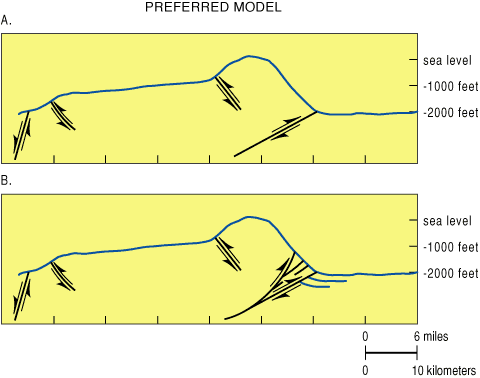
The major conclusion of this paper is that there may be a potential new oil play to be made by exploring under the Nemaha. Although the boundary faults of the Nemaha are partly strike slip, the major measurable offset is vertical. Earthquake history, Precambrian structural history, drilled duplicated sections, and theoretical restorations of movements suggest thrust or reverse faulting be considered in evaluating the Nemaha Ridge structure. Models suggest that the amount of overthrust on the eastern flank can range between 1,650 ft (503 m) and over 2 mi (3.2 km). Such displacement can easily accommodate slices of Paleozoic reservoir rocks in trap position. Fault burial of Arbuckle and Simpson rocks could enhance local oil generation by placing these rocks within the oil window.
The major contribution of this work is to bring a number of disparate elements together, describe their interplay, and describe potential benefit to the industry and to the Kansas economy by virtue of new interpretation. This work, although articulated by one writer, is the work of many people. Besides the citations of preceding literature, debates, discussion, and assistance from W. Lynn Watney, D. F. Merriam, and K. David Newell were vital to understanding many of the complexities of Kansas geology and a guide to the voluminous literature. Susan Nissen provided a needed viewpoint and material assistance in the interpretation of COCORP seismic data. Janice Sorensen kept filling my request for ever more literature, some from remote sources. Gina Ross persevered over the preparation of plate 1, managed to find a way to overlay the Precambrian subsurface on modern drainage without which plate 1 could not have been prepared, and created the final product. Pat Acker has always prepared my illustrations with skill, artistry, and timeliness; she has done so again. I thank Larry Skelton who reviewed this manuscript and made many good suggestions for its improvement, and Marvin P. Carlson of the Nebraska Geological Survey Division, who suggested significant manuscript revisions and with whom I carried on an extensive dialogue about the geologic history of the Midcontinent rift. Marlan Downey, Larry Richardson, and John Rold reviewed the manuscript and made many helpful suggestions for its improvement. All these contributions are appreciated.
After years in the administration of this Survey, this project has led me to better appreciate the technical competence and creativity of the Survey's scientists and staff. I have read some of the most creative and solid conceptual science about the geology of Kansas and its place in the greater North American craton ever written, by my esteemed colleagues. The efficiency and skills of our staff to provide the materials, information, and expertly created products necessary for this project continues to amaze me. I thought I appreciated you and your work from my previous perspective. Now I much better understand what you do for Kansas. Thank you!
Baars, D. L., 1966, Pre-Pennsylvanian paleotectonics--Key to basin evolution and petroleum occurrences in Paradox basin, Utah and Colorado: American Association of Petroleum Geologists Bulletin, v. 50, p. 2,082-2,111.
Baars, D. L., 1995, Basement tectonic configuration in Kansas; in, Geophysical Atlas of Selected Oil and Gas Fields in Kansas, N. L. Anderson and D. E. Hedke, eds.: Kansas Geological Survey and Kansas Geological Society, Bulletin 237, p. 7-9.
Baars, D. L., and Watney, W. L., 1991, Paleotectonic control of reservoir facies; in, Sedimentary Modeling: Computer Simulations and Methods for Improved Parameter Definition, E. K. Franseen, W. L. Watney, C. G. St. C. Kendall, and W. Ross, eds.: Kansas Geological Survey, Bulletin 233, p. 253-262.
Baars, D. L., Thomas, W. A., Drahovzal, J. A., and Gerhard, L. C., 1995, Preliminary investigations of basement tectonic fabric of the conterminus USA; in, Basement Tectonics, R. W. Ojakangas et al., eds.: Kluwer Academic Publishers, Netherlands, p. 149-158.
Berendsen, P., 1997, Tectonic evolution of the Midcontinent Rift System in Kansas; in, Middle Proterozoic to Cambrian Rifting, Central North America, R. W. Ojakangas, A. B. Dickas, and J. C. Green, eds.: Geological Society of America, Special Paper 312, p. 235-241.
Berendsen, P., 1999, Kansas Geological Survey's new initiative in the Manhattan 1 degree x 2 degree quadrangle, northeastern Kansas; in, Transactions of the American Association of Petroleum Geologists Midcontinent Section Meeting, D. F. Merriam, ed.: Kansas Geological Society and Kansas Geological Survey, Open-file Report 99-28, p. 125-133.
Berendsen, P., and Blair, K. P., 1986, Subsurface structural maps over the central North American rift system (CNARS), central Kansas, with discussion: Kansas Geological Survey, Subsurface Geology Series 8, 20 p., 7 over-size plates. [available online]
Berendsen, P., Borcherding, R. M., Doveton, J., Gerhard, L., Newell, K. D., Steeples, D., and Watney, W. L., 1988, Texaco Poersch #1, Washington County, Kansas--Preliminary geologic report of the pre-Phanerozoic rocks: Kansas Geological Survey, Open-file Report 88-22, 116 p. [available online]
Bickford, M. E., Harrower, K. L., Nusbaum, R. L., Thomas, J. J., and Nelson, G. E., 1979, Preliminary geologic map of the Precambrian basement rocks of Kansas: Kansas Geological Survey, Map M-9, scale 1:500000 [available online]
Bickford, M. E., Van Schmus, W. R., and Zietz, I., 1986, Proterozoic history of the midcontinent region of North America: Geology, v. 14, p. 492-496.
Bump, A. P., 2003, Reactivation, trishear modeling, and folded basement in Laramide uplifts--Implications for origins of intra-continental faults; GSA Today, v. 13, no. 3, p. 4-10.
Bunte, A. S., and Fortier, L. R., 1941, Nikkel Pool, McPherson and Harvey counties, Kansas; in, Stratigraphic Type Oil Fields--A Symposium, A. E. Levorson, ed.: American Association of Petroleum Geologists, Tulsa, OK, p. 105-117.
Burchett, R. R., Wilson, F. W., Anderson, R. R., and Kisvarsanyi, E. B., 1983, Precambrian configuration map of Forest City basin and adjacent areas, of Iowa, Kansas, Missouri and Nebraska: Nebraska Geological Survey, Lincoln.
Burgess, P. M., Gurnis, M., and Moresi, L., 1997, Formation of sequences in the cratonic interior of North America by interactions between mantle, eustatic, and stratigraphic processes: Geological Society of America, Bulletin, v. 108, p. 1,515-1,535.
Burruss, R. C., and Hatch, J. R., 1989, Geochemistry of oils and hydrocarbon source rocks, greater Anadarko basin--Evidence for multiple sources of oils and long distance oil migration; in, Anadarko Basin Symposium 1988, K. S. Johnson, ed.: Oklahoma Geological Survey, Circular 90, p. 53-64.
Carlson, M. P., 1997, Tectonic implications and influence of the Midcontinent Rift System in Nebraska and adjoining areas; in, Middle Proterozoic to Cambrian Rifting, Central North America, R. W. Ojakangas, A. B. Dickas, and J. C. Green, eds.: Geological Society of America, Special Paper 312, p. 231-234.
Carlson, M. P., 1999, Transcontinental Arch--A pattern formed by rejuvenation of local features across central North America: Tectonophysics, v. 305, p. 225-233.
Carlson, M. P., 2001, Island arcs, accretionary terranes and midcontinent structure--New understandings of the geologic architecture of the U. S. midcontinent: Resource Notes, Conservation and Survey Division, Lincoln, Nebraska, v. 15, no. 1, p.15-18.
Carlson, M. P., and Treves, S. B., 2000, The Precambrian history of Nebraska and adjacent regions--A record of the accretionary growth of North America; in, Variscan-Appalachian Dynamics--The Building of the Upper Paleozoic Basement: Basement Tectonics 15, A Coruna, Spain, Program and Abstracts, p. 75-78.
Carr, T. R., 2002, Kansas oil and gas production forecasts: Kansas Geological Survey, Open-file Report 2002-57, 17 p. [available online, PDF file]
Carr, T. R., Hopkins, J., Anderson, N. L., and Hedke, D. E., 1995, Case history of Hampton field (Arbuckle Group), Rush County, Kansas; in, Geophysical Atlas of Selected Oil and Gas Fields in Kansas, N. L. Anderson and D. E. Hedke, eds.: Kansas Geological Survey and Kansas Geological Society, Bulletin 237, p. 145-152. [available online]
CD-ROM Working Group, 2002, Structure and evolution of the lithosphere beneath the Rocky Mountains--Initial results from the CD-ROM experiment: GSA Today, v. 12, no. 2, p. 4-10.
Cole, V. B., 1976, Configuration of the top of the Precambrian rocks in Kansas: Kansas Geological Survey, Map M-7, scale 1:500000 [available online, PDF file]
Collins, D., Gerhard, L., Watney, W., Carr, T., and Newell, K., 1994, Potential for discovery and production from the Kansas Crude Oil Resource Base: Kansas Geological Survey, Open-file Report 94-30, 9 p.
Condra, G. E., 1927, Stratigraphy of the Pennsylvanian System in Nebraska: Nebraska Geological Survey, v. 1, 2nd series, 291 p.
Gay, S. P., Jr., 1995, Basement control of selected oil and gas fields in Kansas as determined by detailed residual aeromagnetic data; in, Geophysical Atlas of Selected Oil and Gas Fields in Kansas, N. L. Anderson and D. E. Hedke, eds.: Kansas Geological Survey and Kansas Geological Society, Bulletin 237, p. 10-16. [available online]
Gay, S. P., Jr., 1999, Strike-slip, compressional thrust-fold nature of the Nemaha system in eastern Kansas and Oklahoma; in, Transactions of the American Association of Petroleum Geologists Midcontinent Section Meeting, D. F. Merriam, ed.: Kansas Geological Society and Kansas Geological Survey, Open-file Report 99-28, p. 39-50.
Gay, S. P., Jr., 2003a, The Nemaha trend--A system of compressional thrust-fold, strike-slip structural features in Kansas and Oklahoma, Part 1: The Shale Shaker, v. 54, no. 1, p. 9-17.
Gay, S. P., Jr., 2003b, The Nemaha trend--A system of compressional thrust-fold, strike-slip structural features in Kansas and Oklahoma, Part 2 (Conclusion): The Shale Shaker, v. 54, no. 2, p. 39-49.
Gerhard, L. C., 1967, Paleozoic geologic development of the Canon City embayment, Colorado: American Association of Petroleum Geologists, Bulletin, v. 51, no. 11, p. 2,260-2,280.
Gerhard, L. C., and Anderson, S. B., 1979, Oil exploration and development in the North Dakota Williston basin: North Dakota Geological Survey, Miscellaneous Series no. 57, 19 p.
Gerhard, L.C., Anderson, S. B., and LeFever, J., 1987, Structural history of the Nesson anticline, North Dakota; in, Williston Basin--Anatomy of a Cratonic Oil Province, Peterson et al., eds.: Rocky Mountain Association of Geologists, p. 337-353.
Gerhard, L. C., Anderson, S.B., Carlson, C., and LeFever, J., 1982, Geological development, origin, and energy and mineral resources of the Williston basin, North Dakota: American Association of Petroleum Geologists, Bulletin, v. 66, no. 8, p. 989-1,020.
Gerhard, L. C., and Anderson, S. B., 1988, The Williston basin--Sedimentary cover--North American Craton--U.S.: Geological Society of America, Chapter 9, Geology of North America, D-2, p. 221-242.
Gerhard, L. C., Anderson, S. B., and Fischer, D. W., 1991, Petroleum geology of the Williston basin; in, Petroleum Geology of Interior Cratonic Basins, M. Leighton, D. Kolata, D. Oltz, and J. Eidel, eds.: American Association of Petroleum Geologists, Memoir 51, Chapter 29, p. 507-559.
Gerhard, L. C., Brady, L., Watney, W. L., and Collins, D., 1992, Fossil energy resources in Kansas, 1992: Kansas Geological Survey, Open-file Report 92-9, 53 p.
Gussow, W. C., 1954, Differential entrapment of oil and gas--A fundamental principle: American Association of Petroleum Geologists, Bulletin, v. 38, p. 816-853.
Hambleton, W. W., 1989, Some late night thoughts about geology and geophysics; in, Geophysics in Kansas, D. Steeples, ed.: Kansas Geological Survey, Bulletin 226, p. 303-305. [available online]
Haraldson, N. L., Knapp, R. W., and Newell, K. D., 1995, Seismic response of the east flank of the Central Kansas uplift, Rice County, Kansas; in, Geophysical Atlas of Selected Oil and Gas Fields in Kansas, N. L. Anderson and D. E. Hedke, eds.: Kansas Geological Survey and Kansas Geological Society, Bulletin 237, p. 47-52. [available online]
Haworth, Erasmus, and Bennett, John, 1908, Chapter 3, General Stratigraphy; in, Special Report on Oil and Gas: The University Geological Survey of Kansas (Kansas Geological Survey), v. IX, p. 57-159.
Inden, Richard, and Frush, Penny, 2002, Examples of aeromagnetic exploration in intracratonic basins: PI/Dwights Plus Drilling Wire, Rocky Mountain Regions, Northern Edition/Section 1, Denver, p. 7-12
Jewett, J. M., 1951, Geologic structures in Kansas: Kansas Geological Survey, Bulletin 90, part 6, 172 p. [available online]
Kansas Geological Survey, 2000, Generalized geologic map of Kansas: Kansas Geological Survey,
Kruger, J. M., 1996, On-line gravity and magnetic maps of Kansas: Kansas Geological Survey, Open-file Report 96-51, available online
Lam, C.-K., and Yarger, Harold, 1989, Bouguer gravity map of Kansas; in, Geophysics in Kansas, D. Steeples, ed.: Kansas Geological Survey, Bulletin 226, pocket. [available online]
Lee, Wallace, 1943, The stratigraphy and structural development of the Forest City basin in Kansas: Kansas Geological Survey, Bulletin 51, 142 p. [available online]
Lyons, P. L., 1959, The Greenleaf Anomaly, a significant gravity feature; in, Symposium on Geophysics in Kansas, W. W. Hambleton, ed.: Kansas Geological Survey, Bulletin 137, p. 105-120. [available online]
Marshak, Stephen, and Paulson, Timothy, 1996, Midcontinent U. S. fault and fold zones--A legacy of Proterozoic intracratonic extensional tectonism?: Geology, v. 245, p. 151-154.
McBee, William, 2003, Nemaha strike-slip fault zone: American Association of Petroleum Geologists, Search and Discovery, 6 p., http://www.searchanddiscovery.net/documents/2003/mcbee/index.htm
Merriam, D. F., 1956, History of earthquakes in Kansas: Seismological Society of America, Bulletin, v. 46, no. 2, p. 87-96
Merriam, D. F., 1960, Preliminary regional structural contour map on top of Mississippian rocks in Kansas: Kansas Geological Survey, Oil and Gas Investigations 22, map. [available online, PDF file]
Merriam, D. F., 1963, The geologic history of Kansas: Kansas Geological Survey, Bulletin 162, 307 p. [available online]
Merriam, D. F., and Smith, P., 1961, Preliminary regional structural contour map on top of Arbuckle rocks (Cambrian-Ordovician) in Kansas: Kansas Geological Survey, Oil and Gas Investigations 25, map. [available online, PDF file]
Merriam, D. F., Winchell, R. L., and Atkinson, W. R., 1958, Preliminary regional structural contour map on top of the Lansing Group (Pennsylvanian) in Kansas: Kansas Geological Survey, Oil and Gas Investigations 19, map. [available online, PDF file]
Moore, R. C., 1918, Geologic history of crystalline rocks in Kansas: American Association of Petroleum Geologists, Bulletin, v. 2, p. 98-113.
Moore, R. C., and Haynes, W. P., 1917, Oil and gas resources of Kansas: Kansas Geological Survey, Bulletin 3, p. 140-173. [available online]
Newell, K. D., 1996, Lithofacies and diagenesis of the Upper Ordovician Viola Formation on the Central Kansas arch and adjacent areas: Kansas Geological Survey, Open-file Report 96-10, 610 p.
Newell, K. D. and Hatch, J. R., 1999, Petroleum geology and geochemistry of a production trend along the McPherson anticline, in central Kansas, with implications for long- and short-distance oil migration; in, Transactions of the American Assocociation of Petroleum Geologists Midcontinent Section Meeting, D. F. Merriam, ed.: Kansas Geological Society and Kansas Geological Survey Open-file Report 99-28, p. 22-28.
Newell, K. D., Watney, W. L., Chang, S. W. L., and Brownrigg, R. L., 1987, Stratigraphic and spatial distribution of oil and gas production in Kansas: Kansas Geological Survey, Subsurface Geology Series 9, 86 p. [available online]
Price, L., 1980, Shelf and shallow basin oil as related to hot-deep origin of petroleum: Journal of Petroleum Geology, v. 3, p. 91-116.
Rich, J. L., 1931, Function of carrier beds in long-distance migration of oil: American Association of Petroleum Geologists, Bulletin, v. 15, p. 911-924.
Rich, J. L., 1933, Distribution of oil pools in Kansas in relation to pre-Mississippian structure and areal geology: American Association of Petroleum Geologists, Bulletin, v. 17, p. 793-815.
Roehl, Nelda, Knapp, R. W., and Newell, K. D., 1989, Seismic-reflection study in Rice County, Kansas; in, Geophysics in Kansas, D. Steeples, ed.: Kansas Geological Survey, Bulletin 226, p. 81-94. [available online]
Serpa, L., Setzer, T., and Brown, L., 1989, COCORP seismic-reflection profiling in northeastern Kansas; in, Geophysics in Kansas, D. Steeples, ed.: Kansas Geological Survey, Bulletin 226, p. 176. [available online]
Scott, R. W., 1966, New Precambrian (?) formation in Kansas: American Association of Petroleum Geologists, Bulletin, v. 50, p. 380-384.
Silverman, M. R., ed., 2002, Recent advances in the use of gravity and magnetics for petroleum exploration: IHS Energy Group Petroleum Frontiers, Denver, CO, 84 p.
Smith, R. K., and Anders, E. L, Jr., 1951, Geology of the Davis Ranch oil pool, Wabaunsee County, Kansas: Kansas Geological Survey, Bulletin 90, pt. 2, p. 13-52. [available online]
Steeples, D. W., 1996, Earthquakes: Kansas Geological Survey, Public Information Circular 3, 5 p. [available online]
Van Schmus, W. R., 1992, Tectonic setting of the Midcontinent Rift System: Tectonophysics, v. 213, p. 1-15.
Van Schmus., W. R., and Bickford, M. E., 1981, Proterozoic chronology and evolution of the midcontinent region, North America; in, Precambrian Plate Tectonics, A. Kroner, ed.: Elsevier, Amsterdam, p. 261-296.
Van Schmus, W. R., Bickford, M. E., and Zietz, I., 1987, Early and Middle Proterozoic provinces in the central United States; in, Proterozoic Lithospheric Series, A. Kroner, ed.: American Geophysical Union, Proterozoic Lithospheric Series, v. 17, p. 43-68.
Van Schmus, W. R., Bickford, M. E., Sims, P. K., Anderson, R. R., Shearer, C. K., and Treves, S. B., 1993, Proterozoic geology of the western midcontinent basement; in, Precambrian Coterminous U. S., J. C. Reed, Jr., M. E, Bickford, R. S. Houston, P. K. Link, D. W. Rankin, P.K. Sims, and W.R. Van Schmus, eds.: Geological Society of America, The Geology of North America, v. C-2, p. 239-259.
Van Schmus, W. R., Bickford, M. E., and Turek, A., 1996, Proterozoic geology of the east-central midcontinent basement; in, Basement and Basins of Eastern North America, B. A. van der Pluijm and P. A. Catacosinos, eds.: Geological Society of America, Special Paper 308, p. 7-32.
Walters, R. F., 1958, Differential entrapment of oil and gas in Arbuckle dolomite of central Kansas: American Association of Petroleum Geologists, Bulletin, v. 42, p. 2,133-2,173.
Walters, R. F., 1991, Gorham oil field, Russell County, Kansas: Kansas Geological Survey, Bulletin 228, 111 p. [available online.]
Wilson, F. W., and McCauley, J. R., 1989, The relationship of remote-sensing anomalies to the real world--Examples from the midcontinent and the CUSMAP study areas; in, U.S. Geological Survey-Missouri Geological Survey Symposium--Mineral Resources Potential for the Midcontinent, Program and Abstracts, St. Louis, MO, April 11-12: U.S. Geological Survey, Circular 1043, p. 45.
Woelk, T. S., and Hinze, W. J., 1991, Model of the Midcontinent Rift System in northeastern Kansas: Geology, v. 19, p. 277-280.
Woelk, T. S., and Hinze, W. J., 1995, Midcontinent Rift System in northeastern Kansas; in, N. L. Anderson and D. E. Hedke, Geophysical Atlas of Selected Oil and Gas Fields in Kansas, Kansas Geological Survey and Kansas Geological Society, Bulletin 237, p. 22-27. [available online]
Yarger, Harold, 1989, Aeromagnetic map of Kansas; in, Geophysics in Kansas, D. Steeples, ed.: Kansas Geological Survey, Bulletin 226, pocket. [available online]
Prev Page--Petroleum Potential
Kansas Geological Survey
Web version Sept. 15, 2004
http://www.kgs.ku.edu/Current/2004/Gerhard/09_summary.html
email:webadmin@kgs.ku.edu