Kansas Geological Survey, Current Research in Earth Sciences, Bulletin 250, part 1
Prev Page--Nemaha Ridge || Next Page--Summary
![]()
![]()
![]()
Kansas Geological Survey, Current Research in Earth Sciences, Bulletin 250, part 1
Prev Page--Nemaha Ridge ||
Next Page--Summary
![]()
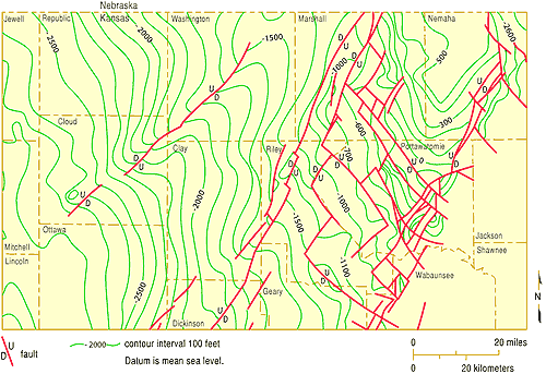
Possible models of deformation across the Nemaha include normal faulting, reverse faulting, thrust faulting (lower-angle reverse motion), and combinations of faults with both senses of directions (fig. 17). As an example of the complex fault nature of the Nemaha, Baars and Watney (1991) present a detailed map of interpreted faults in the Kansas subsurface from study of well logs and structure mapping. Berendsen (1999) interpreted a portion of the area in extreme detail in northeastern Kansas, although the direction of dip of faults may vary from his initial diagnosis (fig. 18).
Figure 17--Possible models of fault movements across the Nemaha. Vertical exaggeration 1:47. A. Illustration of common perception of normal fault geometry. B. Steeply dipping reverse faults. C. Eastern margin thrust fault with backthrust and normal faults to the west. D. Thrust faulted eastern and western margins. E. Upthrust eastern margin.
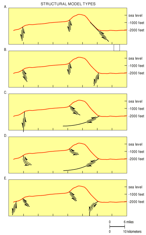
Figure 18--Map showing detailed faulting in extreme northeastern Kansas subsurface, including relative directions of motion that can be measured and interpreted from subsurface data. Direction of dip of fault planes is not indicated. From Berendsen (1999). A larger version of this figure is available.
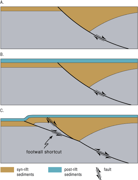
In all cases, the models suggest that west-dipping reverse faults bound the east flank of the Nemaha, rather than normal faults. The petroleum implication of the suggested structural geometries is that potential oil and gas traps exist in reverse or thrust models that are not present in any normal faulted model. Arching of the upper plate to create structural closure, capture of slices of lower plate rocks and folding of lower plate rocks with consequent closure, stratigraphic and fault plane trapping of lower plate rocks against the upper plate, and antithetic faults on upper and lower plates are all possible ways to create petroleum traps (fig. 19).
Figure 19--Generation of traps by reversal of motion, redrawn from Bump (2003). A. Primary normal faulting. B. Sedimentation over primary fault. C. Reversal of motion and creation of slices and "shortcuts."
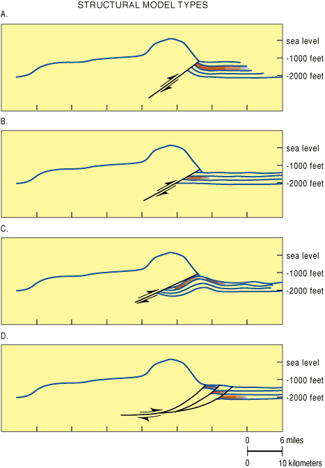
The amount of displacement along boundary faults seems to be greatest in the northern portion of the Nemaha. Calculation of the amount of overthrust possible depends on determining the dip angle of the thrust faults. For steeply dipping thrust (reverse) faults with a dip of 60°, the ratio of horizontal displacement to vertical displacement is 0.5:1, at 45° it is 1:1, and at 30° it is 2:1, and at 15° it is 4:1. For low-angle thrust faults, the horizontal displacement can be many miles. As previously noted, the maximum calculated vertical displacement (Cole, 1976) along the Nemaha in Nemaha County is about 3,300 ft, and is about 2,300 ft in Waubaunsee County. That would mean that a steeply dipping reverse fault in the northern segment could have a horizontal displacement of up to 1,650 ft, about 1/3 mi. If the fault were to dip 30°, the horizontal displacement would be up to 6,600 ft, and at 15°, up to 13,200 ft, or more than 2 mi. Thus the geometry of the fault is critical to exploration success. The preferred model for the Nemaha compro-mises with a dip of less than 45°, but more than 30°, not knowing if the plane is curved or flat (fig. 20).
Figure 20--Structural model types that are possible along the Nemaha. A. Simple upturned drag, potential reservoir sealed at fault plane. B. Truncated reservoir beds. C. Antithetic fold in front of thrust plane. D. Reservoir sliced into segments by secondary faults.
Existing oil pools in the northern portion of the Nemaha are apparently locally sourced by generation within the Forest City basin. About 47 million barrels of oil have been produced from existing fields along the Nemaha trend in the northern 11-county area. Simpson, Maquoketa, Viola, and Hunton rocks are the major target reservoirs; the Arbuckle is absent.
Further south, displacement decreases along the Nemaha. Migration of oil from the Ouachita basin (Chattanooga source) and from the Anadarko basin (Arbuckle source) may provide copious petroleum. Arbuckle through Mississippian reservoirs are potential prospective producing horizons if subthrust traps exist (Newell et al., 1987). Arbuckle reservoirs would be the prime target (Arbuckle is absent in extreme northern Kansas along the Nemaha).
Traps are difficult to locate with existing seismic technology, because the velocity differences are not large between carbonate rocks in many of these units and the granites of the Nemaha. Prospecting will require detailed seismic mapping of the edge of the Nemaha to locate cross structures and other indicators of subthrust potential traps. It is possible that detailed seismic surveys may detect thrust faults at depth, as seen in the COCORP data.
Recognition of once-submerged "up-up" corners of wrench-faulted blocks is another Nemaha-associated potential trap type. The reservoir quality in carbonate beds deposited on slightly elevated blocks is more likely to be enhanced by virtue of greater mechanical energy of shallower waters during deposition, which may increase the likelihood of diagenetic porosity enhancement. While not invariate, it has been a useful exploration tool in carbonate basins. Detailed and large-scale potential-fields (gravity and magnetic) measurements also may be useful. Detailed studies may be able to differentiate between sedimentary and granitic rocks, whereas regional data generalizes small structures and is not capable of distinguishing small differences in density and magnetic susceptibility.
The tool of last resort may be the least expensive and most definitive diagnostic tool, exploratory drilling, particularly in the northern segment where the top of the Nemaha is only a few hundred feet below the surface, and total depth through the prospective thrust sheet could be as little as 3,000 ft. Although industry economics currently do not permit expenditures on high-risk drilling, a consortium of industry and state and federal governments might be able to afford to test the thrust hypothesis with three strategically placed holes spaced along the front of the Nemaha. Any such program must recognize the complex faulting that occurs along the front. A successful new play would pay significant tax and economic-development dividends.
Prev Page--Nemaha Ridge || Next Page--Summary
Kansas Geological Survey
Web version Sept. 15, 2004
http://www.kgs.ku.edu/Current/2004/Gerhard/08_poten.html
email:webadmin@kgs.ku.edu