| Original published in W.W. Hambleton, ed., 1959, Symposium on Geophysics in Kansas: Kansas Geological Survey, Bulletin 137, pp. 105-120 | ||
Sinclair Oil and Gas Company
The complete article is available as an Acrobat PDF file.
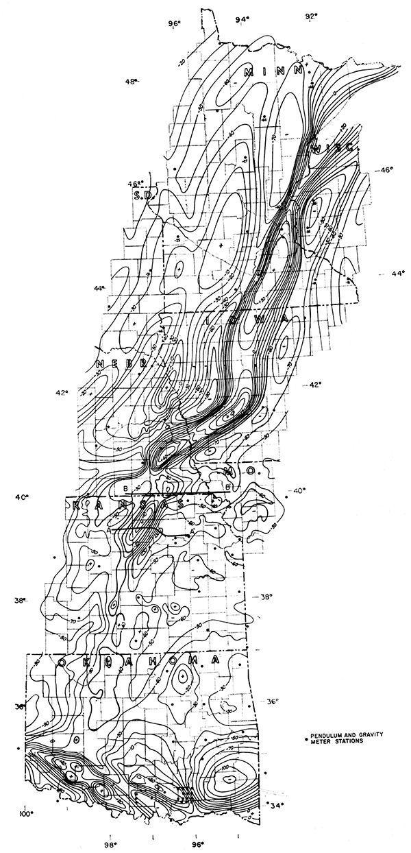
A gravity maximum anomaly, which attains a relief of almost 140 milligals, Bouguer, traverses the Salina Basin of Kansas, extending southward into Oklahoma and northeastward into the Lake Superior area. It represents an ancient tectogene arc about 1,100 miles long and is perhaps related to the Nemaha Uplift to the east. It is interpreted to represent unusually dense rocks at or near the surface of the Precambrian floor, extending the Lake Superior elements far to the south. Continued adjustment of this crustal element has contributed to basin development and structures in the overlying sediments. The anomaly implies that "iron ranges" similar to those of the Superior region may underlie areas flanking its trace in Iowa, Nebraska, Kansas, and Oklahoma.
The most significant gravity maximum anomaly on the North American continent traverses the Salina Basin of Kansas. Attention was directed to it by Woollard (1943), who recorded it on a transcontinental gravity profile, which crosses Kansas in an eastwest direction. The Kansas culmination is in the vicinity of the town of Greenleaf, Washington County, where it reaches a value of +15 milligals, Bouguer. The name Greenleaf Anomaly is proposed for the feature. It is now known to extend southward into Oklahoma, where it may possibly contribute to the gravity culmination of the Wichita Mountains gravity maximum. To the northeast it pursues an S-shaped course through southeastern Nebraska into Iowa. The anomaly is very large and regular in Iowa and the adjacent part of Nebraska; it reaches its greatest culmination of +50 milligals, Bouguer, in the vicinity of Adair, Iowa, in Adair County. Lack of control makes further precise tracing of its true crest difficult, but on the basis of magnetic and subsurface data it may be extended beneath Mason City, Iowa, near the north line of the state, northward through Minneapolis, and it must continue northeastward into the area covered by Lake Superior. The anomaly is shown in Figure 1; heavy contours are used to emphasize its course. Examination of the gravity map of the United States (Lyons, 1950) indicates that this anomaly is of great magnitude and length as compared with other anomalies. The anomaly is too narrow to be altered by isostatic reduction; it is an inequal weight sustained by the earth's crust.
Figure 1--Bouguer gravity map showing Greenleaf anomaly, contour interval 10 mgal.
A truly great frontier of investigation lies in the study and solution of the cause of anomalies such as this; interpretation may have economic as well as academic value.
The anomaly map has been drawn from an assemblage of published data derived from both gravity meter and pendulum observations. Woollard (1958) has made accurate meter observations at airports (where position and elevation are known); these data have been very useful in areas where regional gravity meter or pendulum data are lacking. A density of 2.3 for topographic variation above sea level is assumed. The map is accurate to the contour interval in Oklahoma and Kansas. The profile by Woollard (1943) across the Salina Basin affords a quantitative approach to the extent and magnitude of the causative intrabasement mass in that part of Kansas. A further definition of the feature is afforded by additional geological and geophysical observations that may be brought to bear on its interpretation.
The gravity anomaly maximum coincides with prominent sedimentary basin areas. In Oklahoma it traverses the Anadarko Basin; it continues northward through a part of the Salina Basin, then in succession through parts of the Forest City Basin, the Minneapolis Basin, and the Lake Superior Syncline. In truth, the interpreter is inclined to speculate that isostatic load, represented by this ancient anomaly, has been a factor in the establishment of the sedimentary basins. By contrast, the anomaly at its inception must have marked a high ridge or island arc.
Examination of the magnetic declination map indicates that a pronounced magnetic maximum, large enough to alter locally the lines of equal declination, coincides approximately with the gravity anomaly. Where magnetic surveys are available, they show that the axis of the magnetic maximum coincides closely with the axis of the gravity maximum. In the Anadarko Basin, a magnetic closure of tremendous areal extent marks the broadening of the gravity anomaly (Lyons, in preparation). We can infer that basement rock of greater than normal magnetite content is present, and that possibly the causative materials have some uniformity of geophysical properties along the entire extent of the anomaly, inasmuch as both magnetic susceptibility and density contrasts with adjacent basement rocks seemingly are maintained.
Five igneous plugs reach the surface in Riley County, Kansas, in the vicinity of the town of Riley (Fig. 4). The plugs lie east of the crest of the gravity anomaly, but well on the anomaly; they also lie on the Abilene Arch, an anticlinal feature of low relief. These plugs are composed of basic igneous rock, which has intruded rocks of Permian age. Their presence in the Salina Basin is evidence that crustal forces, initiated in the remote geologic past, may persist through long periods of geologic time.
In the Lake Superior area, late Precambrian sedimentary and volcanic rocks are present; they are ascribed mostly to the Keweenawan Series. The Duluth lopolith, a basic intrusive body, occupies an extensive area north of Duluth, Minnesota. Just south of Lake Superior, and north of the Keweenaw fault, additional basic intrusive rocks crop out at the surface. Lake Superior area rocks include the Beaver Bay diabase, which is believed to represent the upper part of a great gabbro flow that moved toward Lake Superior (Winchell, 1900). The densities of these rocks generally are high, ranging from 2.5 to 2.7. The iron ores of the Mesabi Range and the iron-bearing formations are derived from alteration of sedimentary rocks containing large quantities of green hydrous ferrous silicate (Spurr, 1902); the densities of the iron-bearing formations in the Mesabi district range from 2.7 to 3.0 (Leith, 1903).
Igneous rocks crop out in the Wichita Mountains of Oklahoma. According to Hoffman (1930) they bear a close resemblance to the Duluth intrusive rocks.
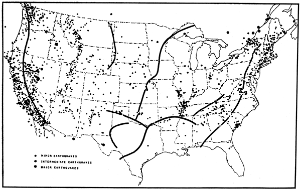
In Figure 2, the arc of the Greenleaf anomaly is shown on a map of the distribution of known earthquake epicenters (Woollard, 1958a). The other positive gravity arcs in the United States also are shown for comparison. Seemingly, such arcs are a manifestation of mountain-building activity, and the Greenleaf anomaly is in an area of recurrent earthquake activity. Occasional earthquakes attributed to the Nemaha belt may also be related to the Greenleaf axis, for the feature seemingly is still active and adjusting. Oddly, the southwestern part of Iowa, where the anomaly attains its greatest value and relief, has been free of earthquakes during our brief history of record.
Figure 2--Map showing distribution of earthquake epicenters in the U. S. through 1957 (after Woollard 1958a) and positive gravity anomaly arcs (based on U. S. Coast and Geodetic Survey data).
The surface expression of the intrabasement anomaly is least evident in Oklahoma, where no surface folds have been observed over the crest. For example, over a local culmination near Medford, Grant County, Oklahoma, there is no surface anticline. There are surface and subsurface folds at the Voshell and McPherson pools in Kansas, however; these folds coincide with the gravity anomaly and their north-south axes almost parallel the axis of the anomaly.
An amazing coincidence occurs in Iowa. In the southwest part of the state, the anomaly has the appearance of being caused by a horst in basement rocks; the boundary faults are indicated by exceptionally steep gravity gradients. The steep gradient on the southeast flank coincides with the Thurman-Wilson fault. This fault reaches the surface but cannot be defined precisely; it was first described by Tilton (1919) on the basis of paleontological evidence. Howell (1919) first delineated this fault on the surface. His choice of location is in agreement with subsurface data and with the position and strike of the steep gravity gradient. The Thurman-Wilson fault has been placed on the tectonic map of the United States, which is in preparation at the present time.
North of this Iowa area, correlation with the surface is again difficult. In the Lake Superior region, the anomaly coincides with the Lake Superior Syncline, a structure exhibiting great thickness of Precambrian sedimentary rocks intruded by basic rocks. Through original composition, metamorphism, or intrusion of basic rocks, this prism would seem to have acquired a density in excess of normal and sufficient to cause the gravity anomaly in that area. One might conclude that a similar basement rock distribution should persist southwestward from Lake Superior into Oklahoma, because the gravity anomaly is continuous.
No subsurface expression of structure coincident with the gravity anomaly has been observed in sedimentary rocks in Oklahoma. There are indications, however, that the geothermal gradient is greater than normal in wells drilled near the anomaly in Oklahoma. In Kansas, a subsurface axis coincident with the anomaly is evident in the Voshell-McPherson-Salina trend of structures; west of the Abilene Arch there is also some evidence of a subsurface axis that coincides with the gravity axis. In Iowa, two wells indicate significant subsurface relief associated with the gravity anomaly. One well, approximately 20 miles east of the highest culmination at Adair, found the Trenton at a depth of 779 feet below sea level. Another well 20 miles southwest at Greenfield, Adair County, across the Thurman-Wilson fault from the first well and on the down thrown side, encountered the Trenton at -1300 feet. A difference in elevation on the Trenton of 500 feet is greater than could be produced by regional dip.
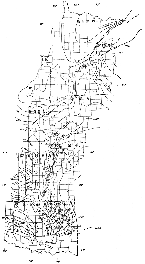
The Nemaha Anticline, or basement uplift, having its southern terminus in the Arbuckle Uplift of Oklahoma, traverses Oklahoma, Kansas, Nebraska, and perhaps Iowa. Structures such as the anticline at Oklahoma City are apparent in the sedimentary rocks over the buried granite of the uplift. The uplift culminates in Nemaha County, Kansas, where the basement reaches elevations higher than 500 feet above sea level. A genetic connection between the Greenleaf anomaly and the Nemaha uplift is suggested by close parallelism of the two. The axis of the Nemaha Anticline maintains a position about 40 miles east of the gravity maximum through Kansas; the pattern changes in southeastern Nebraska. If the Nemaha axis extends into Iowa, its subsurface position may coincide with the anomaly; it also is possible that the Nemaha Anticline intersects the gravity anomaly and continues northward into the Sioux Uplift of South Dakota. This situation is shown on the basement structure map (Fig. 3).
Figure 3--Map showing altitude of basement surface, contour interval 500 feet.
The Nemaha range, in general, occupies a "faded" gravity minimum. The granite in wells penetrating the basement uplift has no appreciable density contrast with the overlying sediments; thus the Nemaha structures do not display gravity maxima other than those associated with the uplift of denser sediments into lighter sediments. Hence the Nemaha gravity anomalies are faint and are isolated as residual gravity anomalies only after regional effects are removed. In this respect, the Nemaha uplift is like many elongate mountain chains having minimal regional Bouguer gravity expression. They thus fulfill the isostatic theorem that many extended mountain chains ride high because the rock column is lighter than surrounding rocks of the crust. It is also noteworthy that such gravity minima are inevitably accompanied by paralleling gravity maxima. Let us speculate that the Nemahas were, at the time of their genesis, represented by a pronounced gravity minimum, which subsequently has faded because processes are operative that can add to the density of a column of rocks, but seemingly there are no processes that will decrease the density of abnormally dense rocks once emplaced near the surface of the crust. We have already speculated that the Greenleaf gravity anomaly is caused by such permanently dense rocks.
The tectogene was named by Kuenen (1936), and the use of the term here is restricted to the observed result of crustal processes, without concern for the changing theories as to the mechanism that brings about the crustal movements. The tectogene designation is applied to present day island arcs in the East and West Indies; tectogenes have been related by Hess (1938) to gravity observations. They and related phenomena have the following characteristics, all of which may be ascribed by comparison to the Greenleaf anomaly and the Nemaha uplift.
The Greenleaf maximum and its associated weak minimum to the east would seem to conform to all the described characteristics of the tectogene elements, except for the magnitude of the negative anomaly. The negative anomaly is pronounced in southwestern Iowa and there is a well-developed minimum closure just east of the Greenleaf culmination; it does not persist as well to the southwest. It would seem reasonable to waive the requirement for a strong negative anomaly, on the basis that the minimum has faded in geologic time as a result of crustal movement, increase of density, and elimination of downward extensions of the crust into the mantle. There is no pronounced maximum present on the concave side of the negative arc, unless it be the Osage Island maximum of northeastern Oklahoma (Cook, 1946). Peridotite intrusives in Wilson County, Kansas (Hambleton and Merriam, 1955), and the magnetic anomalies of this area and their trends suggest a weak positive band.
If the Nemaha Anticline marks the old tectogene trough, it would have been folded first into mountains in Precambrian time. We can speculate that the Nemaha Anticline, the uplift of which was patently post-Mississippian and pre-Pennsylvanian in age, has an older history related to the emplacement of rocks associated with the Greenleaf anomaly. An indication of this is afforded by the observation in some Kansas wells that the Simpson rocks (Ordovician) overlap older rocks of Arbuckle (Cambro-Ordovician) age, therefore uplift existed in Ordovician time, at least. The post-Mississippian uplift of the Nemaha perhaps brought about a measure of isostatic equilibrium and reduced the negative gravity toward zero.
Finally, it would seem that the Greenleaf maximum anomaly represents an extension of the sedimentary prism of the Lake Superior Syncline to the southwest, and that the sedimentary rocks have been intruded extensively by basic rocks, as in the Lake Superior region. The question remains as to the erratic behavior of the maximum, not only as an expression of a syncline-forming element but also as the locus of occasional uplift. The question will perhaps never be answered other than speculatively. In this vein, let us suppose that the weight of the masses involved has caused them either to oppose uplift or founder gradually during geologic time. In such actions, however, an elongate mass certainly would not move in unison. Actually, some portions of it could even be expected to hold firm and resist regional subsidence brought about by other causes, accounting thereby for such features as the horst in southwest Iowa and the uplift of such features as the Voshell Anticline.
Consideration should be given to the puzzling observation that the modern gravity arcs are not in precise correspondence with the troughs and island arcs of the seas; in some there is an indiscriminate "crossing". There is, as yet, no reasonable explanation of this characteristic of tectogenes.
Figure 4--Map showing distribution of basement rocks.
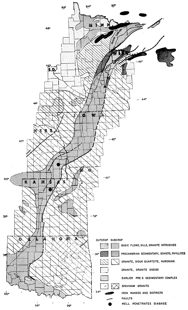
The denser rocks do not seem to be confined entirely to the arcuate anomaly. A curious westward extension appears along the north line of Kansas, and additional extensions are shown in eastern Kansas. Both the Rush and Russell ribs of the Central Kansas Uplift seem to be underlain with dense rock, identified as schist, phyllite, and non-granitic gneiss by Farquhar (1957). That such rocks are denser than the surrounding Precambrian floor is indicated by their coincidence with gravity maxima. The same tendency directs attention to an area in northeastern Oklahoma where the basement rock, called Spavinaw granite, is identified on the map. This area shows a gravity maximum, mapped by Cook (1956); significantly, it is an area of buried basement mountains. The quantitative importance of minor buried topographic features of the basement floor in this area is attested by the presence of about 250 known structural features or anticlines in Osage County, Oklahoma. These domes are traps for a great amount of oil.
One more observation is pertinent, and it emphasizes the importance of a basement-rock distribution map. Where the basement can be identified as being composed of rocks much denser than the sediments overlying them, more confidence may be attached to gravity maps, for there is more density contrast to reflect basement uplift as anomalies. These rocks in northeastern Oklahoma also seem to have a higher magnetic susceptibility than normal granite, thus, similar observations apply to magnetic mapping in such an area.
In the interest of oil exploration, areal maps of the basement should be refined as much as possible. The oil industry should make more effort to drill deliberately into the basement rocks and to collect cores of these rocks for determinations of magnetic susceptibility, density, age, and rock type. Whether basement movement is the sole cause of basinal anticlines or compaction over basement topographic features also causes doming, a study of the basement is important.
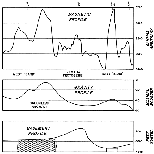
Figure 5 (line A-A' on Fig. 1) shows Woollard's (1943) profile over the Greenleaf anomaly. The gravity anomaly and the steep gradients shown require that the rocks have a density contrast of 0.3 or 0.4 at a depth as shallow as the basement surface, and a downward continuation. Only basic igneous rocks satisfy these requirements. The causative feature must be about 33 miles in width. Figure 6 (line B-B' on Fig. 1) shows a similar gravity profile along the north line of Kansas, as well as a magnetic profile reported by Jensen (1949). The gravity and magnetic profiles are very similar, and they illustrate very well the concept of the tectogene as shown by geophysical measurements. Basement profiles (Fig. 5, 6) show the uplifted, less dense central mass and the belts of faulting and basic intrusion.
Figure 5--Gravity and basement profiles along Woollard (1943) traverse in Kansas.
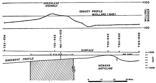
Figure 6--Magnetic, gravity, and basement profiles along north line (40th Parallel) of Kansas.
The iron ranges and districts are noted on the map showing distribution of basement rocks (Fig. 4). Because the iron-bearing rocks flank the Greenleaf anomaly in the Lake Superior area, and are a part of the Precambrian sedimentary series, the fascinating speculation is afforded that similar iron deposits may underlie the sedimentary rocks of Iowa, Nebraska, Kansas, and Oklahoma, flanking the Greenleaf anomaly. It is not impossible to prospect and drill for these deposits under the relatively thin sedimentary cover present in Kansas.
It is believed that the combination of gravity, magnetic, and geologic mapping of regional areas opens a new frontier of interpretation, and that such interpretation can lead to discovery of oil and gas in the sedimentary rocks and of ore deposits in the basement rocks.
Permission to publish this paper is through the courtesy of Sinclair Oil and Gas Company.
Condra, G. E., and Reed, E. C. (1943) The geological section of Nebraska: Nebraska Geol. Survey, Bull. 14, p. 1-82.
Cook, K. L. (1956) Regional gravity survey of northeastern Oklahoma and southeastern Kansas: Geophysics, v 21, p. 88-106.
Farquhar, O. C. (1957) The Precambrian rocks of Kansas: Kansas Geol. Survey, Bull. 127, pt. 3, p. 49-122. [available online]
Hambleton, W. W., and Merriam, D. F. (1955) Magnetic anomalies in Wilson and Woodson Counties, Kansas: Kansas Geol. Survey, Bull. 114, pt. 3, p. 113-128. [available online]
Hess, H. H. (1938) Gravity anomalies and island arc structures with particular reference to the West Indies: Am. Phil. Soc. Proc., v. 79, p. 71-96.
Hoffman, M. G. (1930) Geology and petrology of the Wichita Mountains: Oklahoma Geol. Survey, Bull. 52, p. 1-82.
Howell, J. V. (1919) Petroleum and natural gas in Iowa: Iowa Geol. Survey, v. 29, Ann. Rept., p. 1-48 [1924].
Jensen, Homer (1949) Airborne magnetic profile above 40th parallel, eastern Colorado to western Indiana: Geophysics, v.14, p. 57.
Kuenen, PH. H. (1936) The negative isostatic anomalies in the East Indies (with experiments): Leidse Geol. Meded., v. 8, p. 169-214.
Leith, C. K. (1903) The Mesabi Iron-bearing district of Minnesota: U. S. Geol. Survey, Mon. 43, p. 1-316. [available online]
Lyons, P. L. (1950) A gravity map of the United States: Tulsa Geol. Soc. Digest, v. 18, p. 33-43.
Lyons, P. L. The Pennsylvanian of the Anadarko Basin (in preparation),
Spurr, J. E. (1902) The original source of the Lake Superior iron ores: Amer. Geologist, v. 29, p. 335-349.
Tilton, J. L. (1919) The Thurman-Wilson fault through southwestern Iowa, and its bearings: Jour. Geology, v. 27, p. 383-390.
Vening Meinesz, F. A. (1955) Plastic buckling of the earth's crust--the origin of geosynclines: Crust of the Earth, Geol. Soc. America, Sp. Paper 62, p. 319-330.
Winchell, N. H. (1900) Structural geology: Minnesota Geol. Survey Final Rept., v. 5, p.1-80.
Woollard, G. P. (1943) Transcontinental gravitational and magnetic profile of North America and its relation to geologic structure: Geol. Soc. America Bull., v. 54, p. 747-790.
Woollard, G. P. (1958) Results for a gravity control network at airports in the United States: Geophysics, v. 23, no. 3, p. 520-535.
Woollard, G. P. (1958a) Areas of tectonic activity in the United States as indicated by earthquake epicenters: Amer. Geophys. Union Trans., v. 39, p. 1135- 1150.
Kansas Geological Survey
Comments to webadmin@kgs.ku.edu
Web version Nov. 23, 2013. Original publication date 1959.
URL=http://www.kgs.ku.edu/Publications/Bulletins/137/Lyons/index.html