![]()
![]()
![]()
![]()
![]()
![]()
![]()
![]()
James R. McCauley, Kansas Geological Survey
The Kansas River begins at the confluence of the Smoky Hill and Republican rivers at Junction City and flows 170 miles (272 km) to its mouth in Kansas City, Kansas, where it joins the Missouri River. The Kansas River basin, the area drained by the Kansas River and its tributaries, extends 500 miles (800 km) westward from Kansas City to just northwest of Limon on the High Plains of eastern Colorado. This basin averages 130 miles (208 km) in width and covers an area of just over 60,000 square miles (155,000 km2), which is larger than the state of Iowa. More than half of this drainage, 34,423 square miles (89,155 km2), is in Kansas, covering most of the northern half of the state. Most of Nebraska south of the Platte River, 16,916 square miles (43,812 km2), is drained by the Kansas River as well as 8,775 square miles (22,727 km2) in northeast Colorado (Colby et al., 1956).
Major tributaries of the Smoky Hill River include the Saline and Solomon rivers, which drain much of north-central Kansas. Tributaries of the Republican River include the Arikaree River, which heads in northeastern Colorado, and Frenchman, Red Willow, and Medicine creeks, which drain southwestern Nebraska. Beaver, Sappa, and Prairie Dog creeks drain northwestern Kansas and also flow into the Republican River. Streams that flow directly into the Kansas River include the Big Blue River, a major tributary, and Vermillion Creek, Soldier Creek, Delaware River, and Stranger Creek, which enter from the north. Mill Creek and the Wakarusa River enter the Kansas River from the south. Eighteen Federal reservoirs operated by the U.S. Army Corps of Engineers and the Bureau of Reclamation impound water on all the major tributaries of the Kansas River. Vermillion, Mill, Soldier, and Stranger creeks are the only large tributaries that lack major reservoirs. The Kansas River itself is impounded at Lawrence by Bowersock Dam, a low, hydroelectric dam.
The elevation of the Kansas River basin ranges from about 720 feet (220 m) above sea level at its mouth to nearly 6,000 feet (1,830 m) at Cedar Point in the uppermost drainage of the Arikaree River near Limon, Colorado. Rainfall ranges from slightly more than 35 inches (89 cm) per year in eastern Kansas to less than 16 inches (41 cm) in far western Kansas and eastern Colorado. Annual runoff ranges from more than 5 inches (13 cm) in the east to less than 0.2 inches (0.5 cm) in the west.
The Kansas River basin lies east of the Rocky Mountains in the Great Plains and Central Lowlands physiographic provinces of North America (Schoewe, 1949). This region of nearly flat-lying geologic formations is known as the Stable Interiora region that has not experienced extensive faulting, folding, or mountain building during most of its geologic history. Sedimentary rocks in the basin range in age from Late Pennsylvanian (300 million years ago) to the Recent. The oldest surface rocks in the drainage basin are found at the mouth of the Kansas River. As a general rule the rocks are progressively younger toward the upper reaches of the drainage. West of Wamego the bedrock is Permian in age. Rocks of the Triassic and Jurassic Periods are missing at the surface in the Kansas basin; however, rocks from the next younger geologic period, the Cretaceous, are widespread in north-central Kansas and adjacent parts of Nebraska generally north and west of Salina. Cretaceous rocks at the surface extend into Colorado along the valleys of the Smoky Hill and Arikaree rivers. Most of the western part of the Kansas River basin is underlain by much younger sediments of Pliocene and Miocene age in the form of sands and gravels that have been carried eastward from the Rocky Mountains. The Ogallala Formation is the most widespread and important of these deposits. Unlike the older rocks of the basin which were deposited in marine or near-marine environments, the Ogallala was deposited by freshwater streams in a continental environment well above sea level.
Since its deposition, the Ogallala has been soaking up infiltrating water creating a vast reservoir of fresh ground water that is a major resource in the central and southern Great Plains. Younger deposits dating from the Ice Ages to the Recent cover much of the Kansas River basin. Four major and four or five minor glacial advances occurred during the Ice Ages. The second major one, the Kansan, was one of the most extensive, reaching as far west as the Big Blue River in Nebraska and Kansas and southward to just beyond the Kansas River. The retreat of this glaciation left behind a combination of ice-deposited material and meltwater-deposited sediments known as drifta poorly sorted mixture of clay, sand, gravel, and even large boulders that covers parts of the extreme eastern portion of the Kansas River basin. Windblown deposits can be found throughout the basin as well. Sand hills are sand dunes that have, at least temporarily, been stabilized by vegetation are found in the northwest part of the basin, especially in northeast Colorado and southwest Nebraska. A more widespread windblown deposit is loess, a fine silt that may have originally been deposited by the melting water of the receding Ice Age glaciers. As these waters dried, this silt may have been transported and redeposited by wind. The thickest loess deposits can be found in the northwest and north-central part of the Kansas River basin from southern Nebraska into northwest Kansas. Thick deposits also can be found along the Kansas River near its mouth in the Kansas City area. Much thinner deposits of loess may form a veneer over much of the rest of the Kansas River basin, especially the uplands. The youngest deposits in the basin are the alluvial sediments found in the floodplains and valleys of the Kansas River and its tributaries. Here remnants of slightly older alluvial sediments can also be found in the form of river terraces (Frye and Leonard, 1952).
The floodplain of the Kansas River is sometimes called the valley floor. However, this is not the true bottom of the valley; it merely represents the upper surface of the alluvial sediment that fills the valley. The true valley floor is an irregular trough cut deeper into the bedrock that is mostly buried by the river's sediment. The deepest part of this trough is like a buried channel that meanders down the course of the Kansas River valley beneath the floodplain. This channel differs markedly from the present-day course of the Kansas River. The paths of the two channels cross each other at numerous places along the length of the valley and only coincide near the river's mouth. As a result, the deepest point of the valley or the thickest accumulation of alluvium along any line crossing the valley is unlikely to lie beneath the present position of the river. At a few locations in the lower reach, the river flows directly on bedrock. The thickness of this alluvial fill reaches 95 feet (29 m) with the thickest deposits located where the buried channel underlies some of the higher standing terraces (Beck, 1959). This thick alluvial trench is saturated with ground water up to or close to the level of the river itself. The upper limit of this saturation is the water table. Excavations in the floodplain in the form of sand pits or barrow pits often fill with water, the surface of which is the water table in that vicinity. These water-saturated sediments make up the Kansas River alluvial aquifer, a major freshwater resource in northeast Kansas, a region that otherwise lacks major freshwater aquifers.
The size of sediment in the Kansas alluvium ranges from cobbles and small boulders to clay size. Most of the sediment is silt, sand, and small gravel. The size of sediment a stream can carry depends on the stream's energy. Fast-flowing water is capable of moving larger rock fragments than slow-moving water. Coarser material is generally found at the bottom of the alluvial fill and the terrace deposits, and in the active river channel. The sediment generally decreases in grain size upward and away from the river channel. These fine sediments represent flood deposits laid down some distance from the river. However, coarser sand can be interbedded with finer material throughout the column of alluvium, representing buried channel deposits. Streams can be rejuvenated by events occurring in or near their drainage basins. An increase in precipitation can increase the amount of water flowing in a stream giving it the power to do more work--carrying larger-sized sediment and larger quantities. This could be due to a long-term climatic increase in precipitation, which may cause the river to deepen its channel and alter the entire river valley. A short-term increase in precipitation can cause floods such as the ones in 1951 and 1993.
The flow in a river can be increased by excessive runoff in the basin such as might occur during the latter stages of an ice age when the glacial ice is melting. This melting glacier also would supply large amounts of sediment that was previously eroded from the landscape by glacial actions. Tectonic uplift in the upper reaches of a basin or the tilting of a basin as a whole can create more topographic relief, which results in greater potential energy of flowing water, steeper gradients of streams, and rejuvenation. Such uplift results in headward erosion by streams and the expansion of the drainage basin.
Conversely those conditions that decrease the energy of streams lessen their sediment-carrying power and slow cutting action. The change to a much drier climate with decreased runoff can do this, as can the change to a much colder climate. During part of a glacial age most of the precipitation may fall and remain in solid form, decreasing runoff and streamflow. Downcutting of streams over long periods of time tends to flatten their gradients, resulting in less energetic streams. Likewise, gradients can be flattened by uplift in the lower portions of the drainage basin. During times of decreased energy, streams tend to deposit sediment, building up their floodplains.
Conditions that decrease the amount of sediment entering a stream may result in that stream eroding its own river bed and bring on a period of downcutting and valley deepening. This may occur naturally during the latter stages of a glacial retreat when vegetation reestablishes itself over the barren landscape left in the glacier's wake. The vegetation stabilizes the landscape, making it much less erodable and decreasing the sediment available to streams. Streams would then begin eroding old sediment previously deposited in their beds. Sediment supply can be restricted artificially by the construction of dams on major tributaries that block the movement of all but the suspended portion of a river's sedimentary load.
The nature of the sediment in the Kansas River is a reflection of the geologic composition of its drainage basin. Much of the coarsest material in the alluvium is limestone and chert which is widespread throughout the Kansas River valley. Silt and sand, most of it quartz, comprise the bulk of the river's alluvium. Quartz is a mineral that is hard, has a crystal structure that resists fracture, and is chemically very stable. Quartz resists weathering and abrasion. Most people envision sand as quartz sand. The bedrock in the Kansas River valley does contain some quartz sand. A few sandstones and siltstones crop out; however, sand created from these rocks is generally finer than the sand of the Kansas River. Most of this river sand has its source in the glacial sediments of the lower Kansas River basin and in the Ogallala Formation in the upper part of the basin. Quartz is a major component of granitic rocks that are found in the Rocky Mountains and the Canadian Shield. These are the ultimate sources of most of the Kansas River sand. The erosion of the Rocky Mountain by streams flowing out and dissipating on the Great Plains formed the Ogallala Formation; the Kansan glacier, with its accumulation center near Hudson Bay and grinding trek across southern Canada and the northern United States, left Kansan glacial drift in its wake. Both of these deposits are rich in coarse sand that ultimately ended up in the Kansas River.
Kansas River sand also has a small component of feldspar, a mineral found in granitic rocks in even larger proportions than quartz. Feldspar has cleavage planes and is slightly softer than quartz; it is therefore, less durable, which is why it makes up a smaller fraction of sand that has traveled a long distance. The Ogallala Formation and the glacial drift also are sources of feldspar. The finer sands and silts of the Kansas River may come from these same sources as well as from the sandstones and siltstones that crop out in the valley and the Cretaceous-age Dakota Formation that crops out in north-central Kansas and contains numerous sandstones. Clays in the glacial drift and clays and shales that are found throughout the Kansas River drainage account for the clay-size portion of the Kansas alluvium.
Numerous tributaries flow into the Kansas River. The largest is the Blue River, which drains 9,600 square miles (24,900 km2), most of it in southeast Nebraska extending north to within a few miles of the Platte River (Colby et al., 1956). The Blue River flows into the Kansas River at Manhattan and is impounded just to the north at Tuttle Creek Dam and Reservoir. As mentioned above, most of the large tributaries of the Kansas River enter from the north. Some of these include Vermillion Creek between Wamego and Belvue, Cross Creek at Rossville, Soldier Creek at Topeka, the Delaware River at Perry, and Stranger Creek at Linwood. The Delaware River is dammed at Perry Lake just northwest of Perry. Those large tributaries entering the Kansas River from the south are Mill Creek at Maple Hill and the Wakarusa River at Eudora. The Wakarusa River is dammed at Clinton Lake just southwest of Lawrence. Cedar Creek at De Soto, Mill Creek at Shawnee, and Turkey Creek in Kansas City are small tributaries that drain urbanized areas of Johnson and Wyandotte counties and can carry large amounts of runoff during heavy rains.
The Kansas River Corridor
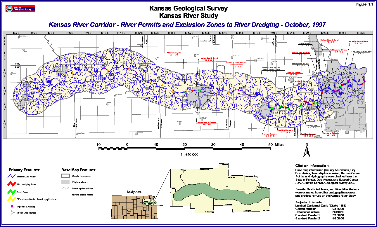
This report focuses primarily on that part of the Kansas River basin that is along and 6 miles (9.6 km) on either side of the Kansas River from its source at Junction City to its confluence with the Missouri River at Kansas City, an area of 1,700 square miles (4,400 km2). Various features of the study area are shown on the accompanying four plates. Figure 1.1 shows the drainage patterns, towns, river miles and permits, and restricted areas of dredging operation. All of the study area drains into the Kansas River except some small areas in the extreme east that drain directly into the Missouri River.
FIGURE 1.1--Map of part of northeast Kansas showing the Kansas River corridor; Kansas River dredging permits and dredging exclusion zones as of October 1997; pipeline crossings; river miles measured from the mouth of the Kansas River; drainage in and around the corridor; and counties, cities, and towns. A large version (35" by 21" at 72 pixels per inch) is also available. The large-scale picture is 194k and will take some time to download.
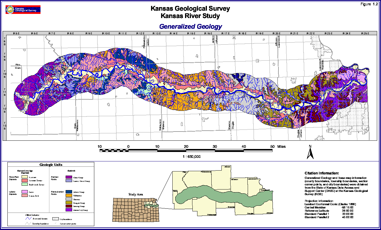
The Kansas River flows along the south edge of an area that physiographically is referred to as the "dissected till plains." The Kansan glacier advanced into this area several hundred thousand years ago and left behind an assortment of sediments. Depositional land forms such as drumlins, eskers, and moraines that are found in the upper Midwest and the northeastern states were formed during more recent glacial periods. Such features were no doubt formed by the Kansan glacier; however, erosion during the long period of time since glaciation has destroyed these distinctive landforms. Glacial deposits are discontinuous in the study area (Figure 1.2). As a result the physiography of the region is determined more by the underlying bedrock and its structure. This bedrock is 270 to 300 million years old, dating back to the Late Pennsylvanian and Early Permian periods of geologic history. It is predominantly a sequence of alternating shales and limestones that were deposited in shallow seas that covered the central United States during that time. Sandstones and some thin coals also appear in this sequence. These rocks are nearly horizontal; however, they have a slight dip or inclination downward toward the west-northwest reflecting the uplift of the Ozark Dome in southeastern Missouri. The limestones in this sequence are more resistant to erosion than the softer shales and sandstones; as a result they tend to stand out in topographic relief, forming a series of slightly inclined table lands with gentle westward slopes and more pronounced and dramatic eastward slopes. Such a feature is known by the Spanish word "cuesta," which means slope. Cuestas are the dominant landform in the study area, and the physiographic region from roughly Wamego eastward is named the Osage Cuestas. That area west of Wamego physiographically is designated the Flint Hills. Some of the limestones in this area contain large amounts of a hydrated amorphous silica known to geologists as chert but known locally as "flint"hence the name. Physiographically the Flint Hills are series of east-facing cuestas just like the region to the east, the difference being that some of the Flint Hill cuestas are more prominent and are mantled by weathered cherty rubble. Where these limestone-capped north-south-trending cuestas intersect the Kansas River, the highest bluffs can be found.
FIGURE 1.2--Generalized geology of the Kansas River corridor. A large version (35" by 21" at 72 pixels per inch) is also available. The large-scale picture is 247k and will take some time to download.
Although distinctive land forms are lacking from the Kansan glacier, the Kansas landscape still reflects the former presence of this huge glacial mass. One of the major glacial features is the Kansas River itself. Its location at or near the margin of this former glacier is not fortuitous but is genetically related. The Kansas River may have originated as an ice-margin stream flowing eastward carrying meltwater and sediment along the edge of the glacier into the Missouri River, another ice-margin stream that closely follows the edge of glaciation in its course across the state of Missouri.
Some of the alluvium deposited by this early Kansas River can be found in old alluvial terraces that are perched along the valley walls well above the present level of the river. These terraces are mapped with glacial drift on Figure 1.2. Since the time of the Kansan glacier, the Kansas River has deepened its valley, cutting into bedrock during times of high flow and partially filling up its valley by dropping sediment during times of low flow. The result today is a deep bedrock trench of varying depth that contains the Kansas River and its alluvial sediment. The maximum depth of alluvial material in the floodplain is about 95 feet (28 m). The floor of the Kansas River valley is generally flat and bordered on its sides in most places by steep bluffs. These bluffs vary from about 25 feet (8 m) to nearly 400 feet (120 m) above the valley floor. The highest bluffs occur just southeast of Manhattan at Fremont Point. Bluffs of 150 feet (45 m) or more are fairly common along the length of the river. The highest point in the Kansas River Corridor, in southeast Riley County, is 1,526 feet (465 m) above sea level. This is slightly more than 800 feet (245 m) above the lowest point in the corridor at the mouth of the Kansas River.
The flat bottom of the river valley is sometimes called bottomland, the bottoms, or the floodplain. The term floodplain, as used by geologists, is the expanse of alluvium that covers the valley floor. The floodplain is formed, as the name implies, at times of flood when the river spreads beyond its banks across the valley floor. When it does so, it carries sediment and as the flood subsides, a sheet of sediment is left in its wake. These overbank flood deposits are often composed of fine silts and clays, especially when deposited at some distance from the river. This accounts for the fine-grained nature of the alluvial sediment near the surface of the floodplain. Parts of the floodplain, though flat, stand above the valley floor closest to the river. These are terraces and represent alluvial deposits left when the river was flowing at higher levels than it is today. These formed during the Ice Ages in the not too distant geologic past. Two such terraces are the Newman Terrace and the higher Buck Creek Terrace (Figure 1.2). Though considered part of the geologic floodplain, these terraces may escape inundation during modern floods.
The Kansas River floodplain contains other topographic features that prevent it from being flat. Among these are meander scars, which are the abandoned bends of the river left when the river changes course. Some of these meander scars contain water and are called ox-bow lakes; examples are Silver Lake located near the like-named town in Shawnee County and Lake View Lake near Lawrence. Other meander scars may contain water only intermittently after heavy rainfall or during times when the water table is high. Today parts of the Kansas River are lined by human-made levees to contain the river at times of flood. However, rivers form natural leveesslightly elevated sections of the floodplain bordering the river that slope gently away from the river. These form at times of flood when the water escapes the constraint of its channel and spreads out onto the floodplain. When it does so its velocity drops dramatically as does its ability to carry sediments. Much of its sedimentary load is dropped adjacent to the river, building up a natural levee; finer sediments, silts and clays, are deposited farther from the river. Floods can also scour out pothole-like depressions in some places and leave behind drifts of sand and silt in others. Loose silt and sand on the floodplain can be moved by the wind into small sand dunes; a few small areas of dune sand are found in the Kansas River floodplain.
The Kansas River floodplain is generally a flat topographic feature; however, it is not level. Like the river itself, it is inclined downstream. The Kansas River valley is 138 miles (220 km) long, while the Kansas River itself is 170 miles (272 km) long. This greater distance is due to the meandering course of the river. In the 148-mile (237-km) stretch between the gaging stations at Fort Riley and Bonner Springs, the river drops 294 feet (89.6 m), giving it an average gradient over this distance of almost exactly 2 feet per mile (0.38 m/km; Fader, 1974). In this same stretch, the floodplain drops a similar amount but does so over a distance of only 120 miles (192 km), giving it a gradient of nearly 2.5 feet per mile (0.47 m/km). The river valley averages 2.6 miles (4.2 km) in width over its 138-mile (220-km) length, giving it an area of roughly 360 square miles (930 km2). The river valley is widest between Wamego and Rossville, where it is up to 4 miles (6.4 km) wide in places. In many places, from its source to Eudora, it is up to 3 miles (4.8 km) wide. Below Eudora, the valley narrows significantly to less than 1.5 miles (2.4 km) and in some of this stretch it is 1 mile (1.6 km) or less in width. Although the Kansas River follows a sinuous path, it seems to prefer the south side of the valley, impinging on the south valley wall at numerous places between Junction City and Lawrence. It touches the north valley wall at only a few places between Junction City and Wamego and once northeast of Topeka. One reason for this preference may be the asymmetry of the Kansas River basin. Most of the large tributaries enter from the north and throughout its course the Kansas River stays very near the southern edge of its drainage. For instance, the Delaware River joins the Kansas River just upstream from Lawrence. The drainage area of the Delaware River extends to within 5 miles (8 km) of Nebraska in northeastern Nemaha County, 60 miles (96 km) north of the Kansas River. In the vicinity of Lawrence, the south edge of the Kansas River basin is only 10 miles (16 km) south of the river. The larger streams entering from the north may have dropped their sediment as they enter the Kansas River valley, building up the north side of the valley and forcing the river to the south bank. Below Lawrence, the river shows no clear preference for either valley wall. The narrow valley and the habit of meandering from valley wall to valley wall over this stretch of the river may explain why there are few terraces below Eudora (Figure 1.2).
The study area includes parts of 11 counties (Figure 1.1) and the Kansas River flows through or borders 10 of these counties including, west to east, Geary, Riley, Pottawatomie, Wabaunsee, Shawnee, Jefferson, Douglas, Leavenworth, Johnson, and Wyandotte. A small part of Jackson County is included in the corridor area; however, the Kansas River does not flow through or touch on this county, thus it is excluded from the 10-county area that is the basis for population discussions. Within the study area are the cities of Junction City, Manhattan, Topeka, Lawrence, and Shawnee as well as parts of Kansas City, Lenexa, Olathe, Overland Park, and Prairie Village, all with populations of 20,000 or more (Table 1.1). Included in the study area are all or part of six of the 10 largest cities in the state. Population figures for the 10 counties adjacent to the Kansas River are summarized in Table 1.2. The 10 counties in the study area have a combined population of 960,420 (KSA 1996, 1990 census, in Helyar, 1997), which is 39 percent of the state's total 1990 population of 2,477,588. The population density of the 10-county area is 182.3 persons per square mile compared to 30.3 for the state as a whole. Eight of the 10 counties experienced population gains between the census years 1980 and 1990, whereas only 28 of the state's 105 counties experienced gains. The study area includes the biggest gain in population, Johnson County, as well as the biggest loser in population, Wyandotte County. The net gain in population in these 10 counties was 110,238 while the gain in population of the state as a whole was 113,352, thus accounting for 97 percent of the net growth. Most of this growth, 84,757 persons, occurred in Johnson County, with Douglas, Leavenworth, Shawnee, and Riley counties showing substantial gains.
TABLE 1.1--1990 population of cities in the Kansas River study area.
| Geary County | Leavenworth County | ||||
| Junction City | 20,604 | Linwood | 409 | ||
| Grandview Plaza | 1,233 | Johnson County | |||
| Fort Riley (partially in Riley County | 14,927 | De Soto | 2,291 | ||
| Riley County | Olathe (Part) | 63,352 | |||
| Ogden | 1,494 | Lenexa (Part) | 34,034 | ||
| Manhattan (partially in Pottawatomie Co.) | 37,712 | Shawnee | 37,993 | ||
| Pottawatomie County | Merriam | 11,821 | |||
| St. George | 397 | Overland Park (Part) | 111,790 | ||
| Wamego | 3,706 | Mission | 9,504 | ||
| Louisville | 215 | Countryside | 312 | ||
| Belvue | 207 | Prairie Village (Part) | 23,186 | ||
| Saint Marys | 1,791 | Roeland Park | 7,706 | ||
| Wabaunsee County | Fairway | 4,173 | |||
| Maple Hill | 406 | Mission Hills | 3,446 | ||
| Shawnee County | Westwood | 1,772 | |||
| Rossville | 1,057 | Westwood Hills | 388 | ||
| Willard | 110 | Mission Woods | 182 | ||
| Silver Lake | 1,390 | Wyandotte County | |||
| Topeka | 119,883 | Bonner Springs | 6,413 | ||
| Jefferson County | Edwardsville | 3,979 | |||
| Perry | 881 | Kansas City | 149,767 | ||
| Douglas County | |||||
| Lecompton | 619 | ||||
| Lawrence | 65,608 | ||||
| Eudora | 3,006 | ||||
TABLE 1.2--Population statistics for the 10-county study area.
| County | 1990 Population | Change 1980-1990 |
Population Density Persons Per Square Mile |
||
|---|---|---|---|---|---|
| Geary | 30,453 | 601 | 79.2 | ||
| Riley | 67,139 | 3,634 | 110.1 | ||
| Pottawatomie | 16,128 | 1,346 | 7.4 | ||
| Wabaunsee | 6,603 | -264 | 8.3 | ||
| Shawnee | 160,976 | 6,060 | 292.7 | ||
| Jefferson | 15,905 | 698 | 29.7 | ||
| Douglas | 81,798 | 14,158 | 179.0 | ||
| Leavenworth | 64,371 | 9,562 | 138.9 | ||
| Johnson | 355,021 | 84,752 | 744.7 | ||
| Wyandotte | 162,945 | -10,309 | 1070.0 | ||
| 10-county population | 960,420 | 10-county net change | 110,238 | 10-county pop. change | 182.3 |
| % of state pop. | 39% | % of net state change | 97% | ||
| state population | 2,477,588 | state net change | 113,352 | state pop. density | 30.3 |
| % of net change in remaining 95 counties | 3% | ||||
Transportation Network
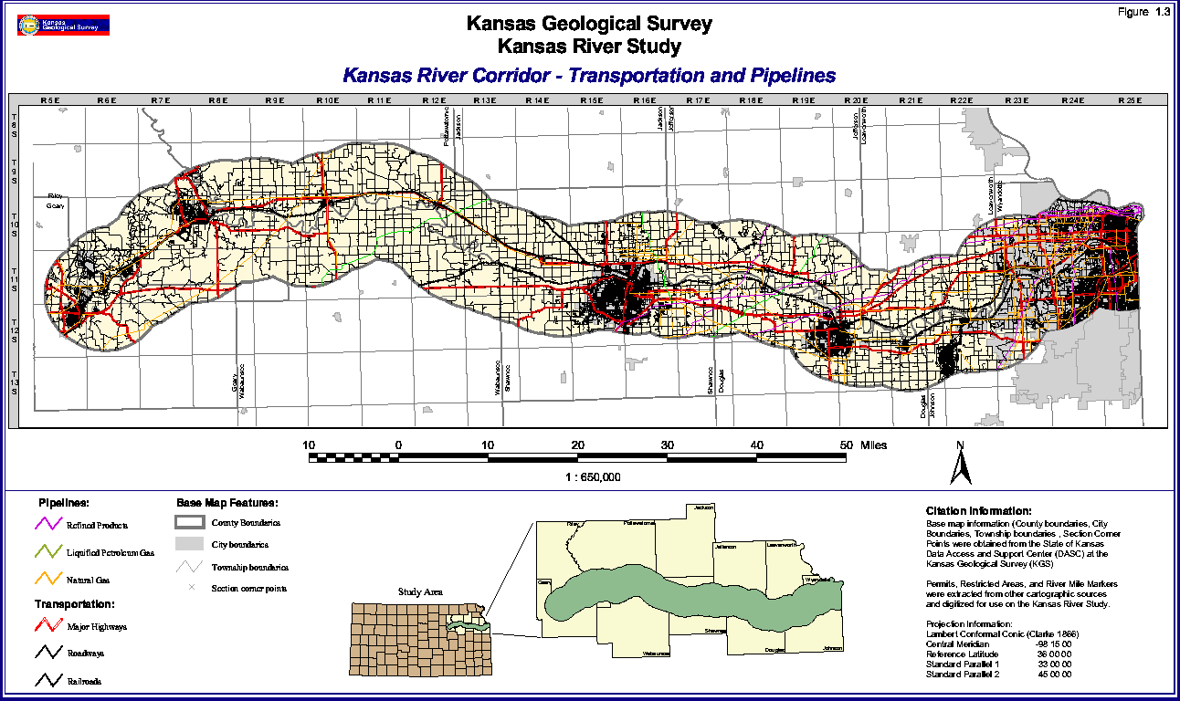
From the earliest arrival of man to this area, the Kansas River and its valley have been avenues of transportation through what would become eastern Kansas. European settlement brought steam navigation to the river in the 1800's; however, the flashy nature of the river and its shallow, braided course during low flows made navigation difficult. Today the Kansas River is classified as a navigable stream, but no commercial navigation operates on its waters. However, the broad valley the Kansas River has cut through the limestone-capped plateaus of eastern Kansas and continues to be an important transportation route into the Modern Age (Figure 1.3).
Railroads--In 1865, the Union Pacific Eastern Division began pushing westward into Kansas from Kansas City along a course that is still operated by the Union Pacific, following the north side of the river west to Junction City and beyond. Just west of Topeka, a branch of the Union Pacific heads northwest, and in Kansas City a Union Pacific line runs northwest along the Kansas side of the Missouri River.
The Atchison Topeka & Santa Fe Railroad, now part of the Burlington Northern Santa Fe Railroad, began building across Kansas in 1868. Its track follows the south bank of the Kansas River between Kansas City and Topeka, where it turns to the south and leaves the study area. Burlington Northern and Santa Fe lines branch off this main line at Shawnee and Topeka and lead south and west out of the study area. A Burlington Northern Santa Fe line also travels through southeastern Wyandotte and northeast Johnson County following the Turkey Creek valley southwest to Olathe and beyond.
FIGURE 1.3--Transportation routes in the Kansas River corridor including three types of pipelines: refined products, liquid petroleum gas, and natural gas; major highways roadways; and railroads. A large version (36" by 21" at 72 pixels per inch) is also available. The large-scale picture is 196k and will take some time to download.
Highways--Two interstate highways cross the study area. I-35 angles across the extreme southeast end of the study area in Wyandotte and Johnson counties; however, it avoids the Kansas River. I-70 enters the study area near Junction City and leaves the study area for a short distance in southeast Riley and northern Wabaunsee counties. The remainder of its route to Missouri is in the study area and very close to the Kansas River in the Junction City, Topeka, Lawrence, and Kansas City areas. I-70 from Topeka to Bonner Springs is also part of the Kansas Turnpike. I-470 connects I-70 west and east of Topeka with the Kansas Turnpike (I-335) to the south. I-670 connects I-70 in Kansas City, Kansas, with I-35 in Kansas City, Missouri. I-435 crosses the study area south to north in Johnson and western Wyandotte counties. I-635 crosses most of the study area south to north in the eastern parts of these two counties.
Other Federal highways include US-24, which enters the study area north of Manhattan and closely follows the north bank of the Kansas River eastward to Lawrence. It briefly leaves the study area in Leavenworth County but returns and travels east through Wyandotte County, joining I-70 just before crossing the Kansas River in Kansas City. US-40 exits I-70 on the east side of Topeka and travels east to Lawrence, where it joins US-24 and continues east. US-69 and 169 cross the extreme east edge of the study area traveling south to north, and US-56 cuts diagonally across the southeast end of the study area in Johnson County. US-73 travels north from Kansas City and Bonner Springs and out of the study area toward Leavenworth. US-59 crosses the study area south to north in the Lawrence area. Likewise US-75 crosses south to north in the Topeka area. US-77 crosses the extreme west end of the study area south to north along the west edge of Junction City.
Numerous state routes cross the study area. Those following the river include K-18 from Junction City east to just south of Wamego. K-32 travels from east of Lawrence to Kansas City. K-10 travels east from just west of Lawrence into Johnson County staying south of the Kansas River. K-177 travels north to Manhattan where it ends. K-99 crosses the study area south to north through Wamego. K-4 travels southwest to northeast in the Topeka area, and K-7 crosses south to north through Olathe and Bonner Springs. K-5 skirts the north edge of the study area in Wyandotte County. Numerous state spurs and connecting highways also exist in the study area such as K-57 and K-244 near Junction City, K-13 and K-113 near Manhattan, K-63 north from Saint Marys, and K-237 near Perry Lake.
An extensive system of county and township roads also exists in the study area, often following the orthogonal land-survey grid of one-mile-square sections. Some of these roads are paved, many are gravel or dirt.
Pipelines--Several pipelines cross the study area. Natural gas pipelines are most numerous in the eastern part of the study area. Additional pipelines are of two types: those carrying refined products and those carrying liquid petroleum gas. Pipelines are shown on Figure 1.3.
River Crossings--Two railroad bridges exist in Topeka. Five railroad bridges cross the Kansas River in its first 2 miles (3.2 km) from its mouth in Kansas City. Thirty bridges carry roads and highways across the river between Junction City and the Missouri River confluence. These are listed in Table 1.3, according to the river mileage as measured upstream from the mouth of the Kansas River. River mileages are shown on Figure 1.1.
TABLE 1.3--Bridge crossings of the Kansas River.
| Approx. River Mile Location |
|
| 0.2 | Railroad bridge downstream from Lewis and Clark Viaduct in Kansas City |
| 0.3 | Lewis and Clark Viaduct--I-70 in Kansas City |
| 0.5 | James Street bridge in Kansas City |
| 0.8 | Railroad bridge in Kansas City |
| 1.1 | Central Avenue bridge in Kansas City |
| 1.4 | I-670 bridge in Kansas City |
| 1.5 | Dual railroad bridge in Kansas City |
| 2.0 | Abandoned railroad bridge in Kansas City |
| 2.1 | Kansas Avenue bridge in Kansas City |
| 2.4 | Railroad bridge in Kansas City |
| 3.3 | 7th Street--US-169 bridge in Kansas City |
| 4.3 | 12th Street bridge in Kansas City |
| 5.0 | 18th Street Expressway--US-69 bridge in Kansas City |
| 5.9 | Kansas Avenue--K-32 bridge in Kansas City |
| 7.2 | I-635 bridge in Kansas City |
| 9.4 | Turner Memorial--K-32 bridge in Kansas City |
| 15.3 | I-435 bridge east of Edwardsville |
| 20.3 | K-7 bridge at Bonner Springs |
| 31.0 | Wyandotte Street bridge at De Soto |
| 42.4 | 222nd Street bridge north of Eudora |
| 51.8 | Massachusetts Street bridge in Lawrence |
| 53.0 | I-70--Kansas Turnpike bridge in Lawrence |
| 63.7 | Lecompton Road bridge at Lecompton |
| 79.7 | K-4 bridge east of Topeka |
| 83.6 | Sardou Avenue bridge in Topeka |
| 83.7 | Santa Fe Railroad bridge in Topeka |
| 84.2 | Kansas Avenue bridge in Topeka |
| 84.5 | Topeka Avenue bridge in Topeka |
| 84.5 | Railroad bridge in Topeka |
| 87.8 | US-75 bridge in Topeka |
| 101.1 | County road between Willard and Rossville at Willard |
| 106.0 | Maple Hill Road between Saint Marys and Maple Hill |
| 115.4 | Schideman Road southeast of Belvue |
| 127.0 | K-99 bridge at Wamego |
| 149.2 | K-177 bridge at Manhattan |
| 163.6 | K-18 bridge south of Ogden |
| 169.0 | Marshall Field bridge at Fort Riley |
Land Use
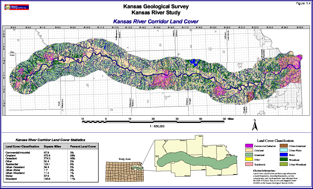
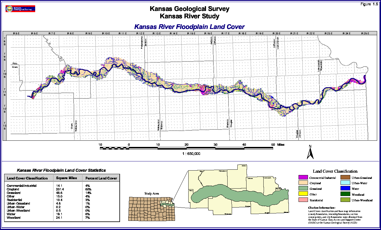
Table 1.4 tabulates the areal extent and percent coverage of 10 different land-cover categories in both the Kansas River study area and in the Kansas River floodplain. The most extensive land cover in the corridor study area is grassland with a coverage of 45 percent, followed by cropland at 28 percent coverage (Figure 1.4). These are the two most widespread land covers in the floodplain as well; however, their order is reversed. Here cropland is predominant, covering 60 percent of the floodplain area, and grassland is a distant second with 14 percent coverage (Figure 1.5). The rich, tillable soils of the Kansas floodplain are the most prized in this part of Kansas and are extensively farmed. Cultivated land outside of the floodplain of the Kansas River extends up the valleys of many of the larger tributaries such as the Big Blue River at Manhattan, Vermillion Creek north of Wamego, and the Wakarusa River south of Lawrence. Some large areas of upland cropland can be found in southern Leavenworth County and in eastern Douglas and western Johnson countiesareas of deeper soils developed on outcrops of shale and soft sandstones and covered in part by glacial drift. Cropland is scattered throughout the uplands from Shawnee County eastward. Westward from Shawnee County the uplands become increasingly covered by grassland, the characteristic land cover of the Flint Hills.
TABLE 1.4--Generalized land use along the kansas River within the corridor and within the floodplain.
| General Class | Floodplain Area | 12-mile Corridor | ||
|---|---|---|---|---|
| % | Sq. Miles | % | Sq. Miles | |
| Commercial/Indus. | 4 | 14.1 | 3 | 47.9 |
| Cropland | 60 | 201.4 | 28 | 472.8 |
| Grassland | 14 | 48.6 | 45 | 774.3 |
| Other | 4 | 15.0 | 2 | 30.4 |
| Residential | 3 | 10.4 | 6 | 103.1 |
| Urban-Grassland | 1 | 4.8 | 2 | 39.4 |
| Urban-Water | 0 | 0.2 | 0 | 1.7 |
| Urban-Woodland | 0 | 0.5 | 1 | 11.2 |
| Water | 6 | 19.1 | 2 | 37.6 |
| Woodland | 7 | 24.1 | 11 | 185.6 |
Woodlands comprise 11 percent of the study area. Some of the larger tracts are in the east half of the study area in the bluffs bordering the Kansas River and some of its small tributaries. Woodlands generally have less coverage west of Topeka, being confined to many small canyons and creek valleys branching off the Kansas River and larger tributaries. In the Fort Riley area northeast of Junction City and north of the Kansas River, the larger tributary valleys are filled with woodlands, whereas in privately owned land south of the river, tributary valleys are mostly cropland. In the floodplain, 7 percent of the land is woodland. Although few large woodland tracts can be found, a discontinuous riparian forest grows along the entire Kansas River.
The next most widespread land cover in the study area is residential, making up 6 percent of the corridor. Most of this classification of course occurs in the larger cities of the study area, metropolitan Kansas City area, Lawrence, Topeka, Manhattan, and Junction City. In the floodplain, the percent land cover of residential areas is 3 percent, or half that of the study area as a whole. Much of this is again in the larger cities; however, several small towns lie completely in the floodplain, such as Ogden, Belvue, Rossville, Silver Lake, Perry, and Linwood.
FIGURE 1.4--Land-cover map and statistcs for the Kansas River corridor. A large version (36" by 22" at 72 pixels per inch) is also available. The large-scale picture is 278k and will take some time to download.
In the floodplain, residential land cover is exceeded by water and a classification known as "other." Water comprises 6 percent of the floodplain but only 2 percent of the study area as a whole. Of course the most prominent body of water in the floodplain is the Kansas River itself. Smaller areas of water are the tributaries and drainage ditches that empty into the river and the oxbow lakes and other abandoned river courses that hold water. Oxbows include lakes near Ogden, Eureka Lake southwest of Manhattan, Silver Lake at Silver Lake, and Lake View Lake northwest of Lawrence. Additional bodies of water are sand pits, borrow pits, and sewage-disposal ponds.
FIGURE 1.5--Land-cover map and statistics for the Kansas River floodplain. A large version (36" by 22" at 72 pixels per inch) is also available. The large-scale picture is 143k and will take some time to download.
Whereas water coverage in the floodplain is 6 percent, it is only 2 percent in the study area as a whole. The largest body of water in the study area is the lower end of Perry Lake northwest of Perry. A small part of Tuttle Creek Reservoir north of Manhattan is also in the study area as are the ponds located below both Tuttle Creek and Milford dams, the latter being just northwest of Junction City. Three large lakes associated with the Jeffrey Energy Center in southeastern Pottawatomie County also contribute to this 2 percent coverage as do the larger streams, farm ponds, and watershed lakes that can be resolved by the mapping system.
The classification "other" includes surfaces that are neither soil nor vegetation. These areas could be sand, concrete, or bare rock. Four percent of the floodplain is classified as "other," and most of this is bare sand in sand bars both in and along the Kansas River. Areas of unvege-tated sand near dredges, sand pits, and other excavations also are classified as "other." Some stretches of major highways and their intersections and interchanges are also mapped as "other." In the corridor study area "other" makes up 2 percent of the land surface. As in the floodplain, highways are a major component in this category. Some large industrial facilities contain large bare areas for material and waste storage that fall in this category such as the electrical generating stations along the river east of Topeka and on the north edge of Lawrence. Limestone quarries such as those east of Topeka and east of Bonner Springs and landfills like those north of Lawrence and in Shawnee have large areas of exposed rock and are mapped as "other." Tuttle Creek Dam, Perry Dam, and parts of Milford and Clinton dams as well as their outlet structures and emergency floodways are all areas of rip-rap, concrete, or bedrock mapped as "other."
Commercial/industrial areas comprise 4 percent of the floodplain area and 3 percent of the corridor area. The largest concentration of this category is in the lower Kansas River floodplain in Wyandotte County where major components are railroad yards in addition to manufacturing and warehousing facilities usually associated with this category. As expected, most commercial/industrial areas are in the larger cities, especially in the business districts. Large airports fall in this category as well and most are located in the floodplain, such as Marshall Field at Fort Riley, Manhattan Municipal Airport, and Fairfax Municipal Airport on the Missouri River floodplain in Kansas City. Parts of The University of Kansas in Lawrence, Kansas State University in Manhattan, and Washburn University in Topeka are mapped as commercial/industrial, as are many of the installations at Fort Riley near Junction City.
The remaining categories are urban in nature: urban-grassland, urban-water, and urban-woodland. Combined these make up just 1 percent of the floodplain and 3 percent of the study area with urban-grassland being the dominant category. Parks, cemeteries, golf courses, athletic fields and campuses surrounding universities, hospitals, and other institutions all contribute to this category. Urban woodland comprises 1 percent of the study area and is negligible in the floodplain. Urban-water is negligible in the floodplain and throughout the study area, represented primarily by Lake Sherwood and Lake Shawnee, both near Topeka.
In summary, the combined categories commercial/industrial and residential, which includes most of the built-up areas, cover 7 percent of the floodplain and 9 percent of the study area as a whole. The combination cropland and grassland, which represents most of the agricultural land, covers 74 percent of the floodplain and 73 percent of the study area. Water covers 6 percent of the floodplain and 2 percent of the study area while woodlands cover 7 percent of the floodplain and 12 percent of the study area. The largely barren areas classified as "other" cover 4 percent of the floodplain and 2 percent of the entire study area.
Paleozoic Bedrock
The Paleozoic-age bedrock as mentioned in the pre-vious section on physical geology, was largely deposited in a shallow sea in which the depth of sea water was constantly changing. This changing depth of sea water created different depositional environments and resulted in different types of sediments being deposited. These are represented by the different rock types found today. In general, limestones were deposited in deeper waters, while shales were deposited in shallow water. At times during the retreat of these ancient seas, this area was at or slightly above sea level, and shales, silts, and sandstones were deposited in delta-like coastal environments. Some of these areas supported lush stands of swampy vegetation during Pennsylvanian time that were later buried and converted to thin coal deposits. Many years of geologic mapping and stratigraphic studies have resulted in the recognition and naming of roughly 160 bedrock units in and along the Kansas River valley from Kansas City to Junction City. These individual rock units are often lumped together as members of larger stratigraphic units called formations. These formations each have a geographic name designating the area where they were first described and often have a lithologic name that indicates the dominant lithology. For instance the Oread Limestone is a formation composed of four limestone members and three shale members. The limestone dominates this section of rock. One of these limestones is thick (15-22 ft [4.6-6.7 m]) and caps a prominent escarpment throughout most of the Oread Limestone outcrop area. The Paleozoic bedrock was deposited during a time that includes the latter part of the Pennsylvanian Period and the early part of the Permian Period, a time span of 270 to 300 million years ago. The contact between these two periods is conformable, which means there was no major interruption in sedimentary deposition during this time period. Geologic formations are further lumped together in named groups (Figure 1.2). The downward cutting of the Kansas River west to east and the westward dip of the bedrock combined to make an outcrop pattern of irregular north-south bands of similar rocks. As one travels east to west in the Kansas River valley, one gains elevation and traverses progressively younger outcrops of bedrock.
The geologic groups that make up the bedrock (Figure 1.2), the geologic formations that make up each group, their approximate thicknesses, and composition and comments concerning noteworthy geologic units are shown in Table 1.5.
TABLE 1.5--Bedrock of the Kansas River corridor
| Age | Group | Formations | Thickness (ft) | Rock Type | Comments |
|---|---|---|---|---|---|
| Permian | Chase Group | Winfield Limestone | 24 | 2 limestones (1 limestone is cherty) 2 shales |
Bench former--youngest bedrock in the study area |
| Doyle Shale | 20-25 | 2 shales 1 limestone |
Towanda Limestone Member is quarried for aggregate | ||
| Barneston Limestone | 60 | 2 thick limestones (1 limestone very cherty) 1 thin shale |
Caps the Flint Hills from Manhattan to Junction City--Fort Riley Limestone Member forms rimrock in Fort Riley area that is quarried for aggregate and was quarried for building stone | ||
| Matfield Shale | 50-70 | 2 multicolored shales 1 limestone |
|||
| Wreford Limestone | 40 | 2 cherty limestones 1 shale |
|||
| Council Grove Group | Speiser Shale | 10-20 | multicolored shale | ||
| Funston Limestone | 15 | 3 limestone beds 2 shale beds |
Quarried for building stone | ||
| Blue Rapids Shale | 18 | multicolored shale | |||
| Crouse Limestone | 14 | 2 limestones 1 shale bed |
Prominent bench former | ||
| Easley Creek Shale | 14-18 | shale with thin limestone beds |
Contains gypsum in marshall County where it is mined |
||
| Bader Limestone | 21 | 2 limestones 1 silty shale |
|||
| Stearns Shale | 14 | silty shale | |||
| Beattie Limestone | 20 | 2 limestones (1 cherty, 1 shale) |
Cottonwood Limestone Member is quarried for building stone and aggregate and forms a prominent escarpment | ||
| Eskridge Shale | 32 | silty shale with thin beds of limestone |
|||
| Neva Limestone | 16 | limestone with thin shale beds |
|||
| Age | Group | Formations | Thickness (ft) | Rock Type | Comments |
| Pennsylvanian | Admire Group | Grenola Limestone | 37 | 2 limestones 2 shales |
|
| Roca Shale | 25 | shale with thin limestone beds |
|||
| Red Eagle Limestone | 9-18 | 2 limestones 1 shale |
|||
| Johnson Shale | 25 | silty shale | |||
| Foraker Limestone | 47 | 2 limestones 1 shale |
Americus Limestone Member is quarried for building stone and forms prominent hillside bench | ||
| Janesville Shale | 75 | 2 shales 1 limestone |
May contain one or two coal beds; Five Point Limestone Member is quarried for building stone | ||
| Falls City Limestone | 12-17 | limestone with beds of shale |
|||
| Onaga Shale | 37 | shale and thin limestone beds |
|||
| Wabaunsee Group | Woodsiding Formation | 25 | shales and sandstones 2 thin limestones |
||
| Root Shale | 38 | 2 shales 1 thin limestone |
Contains one or two thin coals | ||
| Stotler Limestone | 10-30 | 2 limestones 1 shale |
Forms a low escarpment | ||
| Pillsbury Shale | 40 | claystone, silty near top |
|||
| Zeandale Limestone | 20 | 2 limestones 1 shale |
Forms a prominent escarpment Lowest member, the Tarkio Limestone, is quarried for aggregate |
||
| Willard Shale | 50-60 | claystone and some sandstones |
|||
| Emporia Limestone | 20 | 1 limestone 1 shale |
|||
| Reading Limestone | 2-3 | single limestone bed | |||
| Auburn Shale | 25-30 | clay with siltstone and thin limestones |
|||
| Bern Limestone | 12-24 | 2 limestones 1 shale |
Forms prominent escarpment Burlingame member is quarried for aggregate |
||
| Scranton Shale | 140 | clay and siltstone 2 thin limestones |
Contains thin coal seam--Elmo coal bed | ||
| Howard Limestone | 11-17 | 2 limestones 2 shales |
Contains the Nodaway coal bed up to 1.4 ft thick | ||
| Severy Shale | 30-35 | clay siltstone and sandstone |
|||
| Age | Group | Formations | Thickness (ft) | Rock Type | Comments |
| Pennsylvanian (continued) |
Shawnee Group | Topeka Limestone | 30 | 5 limestones 4 shales |
Caps bluffs in eastern Shawnee County; Hartford and Curzon members are quarried for aggregate |
| Calhoun Shale | 45-55 | siltstone sandstone and clay |
|||
| Deer Creek Limestone | 40 | 3 limestones 2 shales |
Ervine Creek Limestone Member is quarried for aggregate. Deer Creek Limestone caps bluffs in western Douglas County | ||
| Tecumseh Shale | 70 | clay, siltstone and sandstone |
|||
| Lecompton Limestone | 40 | 4 limestones 3 shales |
Caps the river bluffs in the Perry-Lecompton area | ||
| Kanwaka Shale | 70-80 | shale 1 thin limestone |
|||
| Oread Formation | 45 | 4 limestones 3 shales |
Plattsmouth is the thickest limestone member and is quarried for aggregate. Oread forms a prominent escarpment in the Lawrence area. Toronto and Kereford Limestone Members also quarried for aggregrate | ||
| Douglas Group | Lawrence Formation | 120 | shale with a thick sandstone and thin limestone |
Two sandstones, the Ireland in the Lawrence Formation and Tonganoxie in the Stranger, are freshwater aquifers along and close to their outcrop. The softer Lawrence and Stranger formations form low bluffs in the Lawrence to Eudora area. Contains several thin coals | |
| Stranger Formation | 100 | shale with a thick sandstone member |
|||
| Lansing Group | Stanton Limestone | 25-30 | 3 limestones 2 shales |
The thickest member, the Stoner Limestone, and sometimes the underlying Captain Creek are quarried for aggre gate. The Stanton and the Plattsburg and Wyandotte limestones below cap the higher bluffs from De Soto to the mouth of the river | |
| Vilas Shale | 15-20 | gray sandy shale | |||
| Plattsburg Limestone | 18 | 2 limestones thin shale |
Quarried for aggregate | ||
| Kansas City Group | Lane Shale | 50-60 | shale with 2 or 3 limestones |
||
| Wyandotte Limestone | 26 | 2 limestones 1 thin shale |
Argentine Limestone Member mined and quarried in the Kansas City area for aggregate. Underground mines are developed for storage and other uses after mining | ||
| Liberty Memorial Shale | 45 | silty shale | |||
| Iola Limestone | 12 | 2 limestones a black shale |
|||
| Chanute Shale | 15 | sandy shale | May have a thin coal near top | ||
| Dewey Limestone | 12 | 1 limestone 1 shale |
|||
| Nelly Bly Formation | 2 | shale | |||
| Cherryvale Formation | 45 | 2 shales 2 limestones |
|||
| Dennis Limestone | 20 | 2 limestones thin black shale |
|||
| Galesburg Shale | 2-3 | buff-colored shale | |||
| Swope Limestone | 30 | 2 limestones 1 thin shale |
Oldest formation in the Kansas River valley. Bethany Falls Limestone Member is mined for aggregate at Kansas City in south bluff of the Kansas River and at several places in Kansas City, Missouri, for underground space commonly developed after mining |
(Jewett, 1941; Jewett and Newell, 1935; Johnson and Adkison, 1967; Mudge and Burton, 1959; O'Connor, 1960, 1971; Zeller, 1968)
Quaternary Deposits
The Recent and Ice Age deposits of the Kansas River study area are unconsolidated; that is, they are loose or can be easily disaggregated. These sediments can generally be divided into two categories, those in the floodplain and those deposited in the uplands (Table 1.6). Floodplain deposits in chronologic order are the Buck Creek Terrace, Newman Terrace, and alluvium. The upland deposits are glacial drift and younger loess. The Ice Ages are known geologically as the Pleistocene Epoch, the first part of the Quaternary Period. The latter part of the Quaternary Period, which extends to the present day, is the Holocene Epoch, sometimes referred to informally as the Recent. The Pleistocene Epoch is divided into four major glacial ages separated by three interglacial ages. The oldest major glacial age was the Nebraskan. The Nebraskan glacier did not advance into the study area but did reach the far northeast corner of Kansas where Nebraskan glacial deposits can be found. The next major glacial advance was the Kansan. This glacier, as mentioned previously, extended just south of the Kansas River and west to the Big Blue River and may be responsible for the alignment of both rivers. The Kansan glacier left behind the glacial drift that is mapped on Figure 1.2. Glaciers are poor sorting agents, which means the sediment they transport and deposit is seldom uniform in grain size. As a result, glacial deposits can range from clay size to boulder size. In the study area, clay, silt, sand, gravel, cobbles, and boulders are all found in glacial deposits. Some of the rocks found are from outcrops far removed from the Kansas River valley. Such foreign rocks are called "erratics" by geologists.
Common erratics in the study area are hard pink boulders of quartzite. These rocks are from outcrops of a rock unit known as Sioux Quartzite, which crops out in the area where South Dakota, Minnesota, and Iowa meet. Some Sioux Quartzite boulders found in Kansas are as large as automobiles. Additional metamorphic and igneous erratics from the Canadian Shield region of the upper midwest and Canada can also be found in Kansan drift. Areas mapped as glacial drift also include some alluvial deposits that may be the result of meltwater from the Kansas Glacier. These represent some of the earliest deposits associated with what would become the Kansas River. These deposits are well above the present flood plain of the river; because they are sometimes difficult to separate from the glacial deposits, they are grouped with the glacial drift in Figure 1.2.
During the Illinoian glacial age, the glacial advance did not reach Kansas. However, this was a time of river deepening, and the Kansas River was deepened well below the level it occupied during the Kansas Age. At the end of the Illinoian, the Kansas River began depositing sediment, filling up its valley with alluvium that would become the Buck Creek Terrace. Also, late in the Illinoian Age, loess deposition may have begun. Silt from glacial outwash was blown out of sediment-choked river valleys and distributed over wide areas.
The Wisconsinan Glacier did not reach Kansas but did travel to central Iowa and northeast Nebraska, at the same time glaciers in the central Rockies greatly expanded. At this time the Kansas River cut its channel even deeper and toward the end of the Wisconsinan Age began depositing alluvium, forming a floodplain well below the Illinoian deposits. These older alluvial deposits were left standing above the new floodplain in the form of the Buck Creek Terrace. This newer period of alluvial deposition and floodplain formation, which began in the Wisconsinan Age, may have lasted into the early Holocene or Recent age. Loess deposition was active during the Wisconsinan Age and also may have continued into the early Holocene.
The Holocene period was another time of downcutting by the Kansas River into its alluvial fill and a period of aggradation or building up of its river bed by depositing sediment. This downcutting and aggradation formed the modern floodplain, which is cut below the late Wiscon-sinan Age sediments that are left standing above the modern floodplain in the form of the Newman Terrace (Frye and Leonard, 1952).
TABLE 1.6--Recent and Ice Age deposits.
| Floodplain Deposits | Upland Deposits | |||
|---|---|---|---|---|
| Quaternary Period | Holocene (Recent) Series | Alluvium--0-85 ft sand and silt below modern floodplain grades upward from coarse gravel to silt and silty clay
Newman Terrace--0-90 ft |
Loess--0--100 ft windblown silt | |
| Pleistocene (Ice Age) Series | Wisconsinan Stage | |||
| Illinoian Stage | Buck Creek Terrace--0-95 ft less than 10 ft of sand and gravel at the base; the rest is sandy silt and clay. Buck Creek Terrace lies above modern floods on the Kansas River. | |||
| Kansan Stage | Glacial drift--0--85 ft of clay, silt, sand, gravel, cobbles, and boulders, many erratics, also high terrace deposits of sand, silt, and gravel well above the present floodplain. Deposits are discontinuous in the study area but become more widespread north of the river. | |||
Beck, V. H., 1959, Geology and ground-water resources of Kansas River valley between Wamego and Topeka vicinity: Kansas Geological Survey, Bulletin 135, 88 p. [available online]
Colby, C. C., Dillingham, H. L., Erickson, E. G., Jenks, G. F., Jones, J. O., and Sinclair, R., 1956, The Kansas basin--Pilot study of a watershed: University of Kansas Press, Lawrence, 103 p.
Fader, S. W., 1974, Ground water in the Kansas River valley, Junction City to Kansas City, Kansas: Kansas Geological Survey, Bulletin 206, pt. 2, 12 p. [available online]
Frye, J. C. and Leonard, A. B., 1952, Pleistocene geology of Kansas: Kansas Geological Survey, Bulletin 99, 230 p. [available online]
Helyar, T. (ed.), 1997, Kansas statistical abstract, 1996: Institute for Public Policy and Business Research, University of Kansas, var. pg.
Jewett, J. M., 1941, The geology of Riley and Geary counties: Kansas Geological Survey, Bulletin 139, 164 p. [available online]
Jewett, J. M., and Newell, N. D., 1935, The geology of Wyandotte County, Kansas: Kansas Geological Survey, Bulletin 21, pt. 2, p. 151-205 [available online]
Johnson, W. D., Jr., and Adkison, W. L., 1967, Geology of eastern Shawnee County, Kansas, and vicinity: U.S. Geological Survey, Bulletin 1215-A, p. 1-124 [available online]
Mudge, M. R., and Burton, R. H., 1959, Geology of Wabaunsee County, Kansas: U.S. Geological Survey, Bulletin 1068, 210 p.
O'Connor, H. G., 1960, Geology and ground-water resources of Douglas County, Kansas: Kansas Geological Survey, Bulletin 148, 200 p. [available online]
O'Connor, H. G., 1971, Geology and ground-water resources of Johnson County, northeastern Kansas: Kansas Geological Survey, Bulletin 203, 68 p. [available online]
Schoewe, W. H., 1949, The geography of Kansas, Part 2--Physical geography: Kansas Academy of Science, Transactions, v. 52, no. 3, p. 261-333
Zeller, D. E. (ed.), 1968, The stratigraphic succession in Kansas: Kansas Geological Survey, Bulletin 189, 81 p. [available online]
Previous Page--Introduction || Next Page--Economic Resources