![]()
Prev Page--Introduction || Next Page--Kinderhook or Osage
Mississippian Series
The Mississippian rocks are widely distributed in the Mississippi basin fit the surface and in the subsurface. They were deposited from the Appalachian Mountains westward far beyond the Rocky Mountains. Outcrops of the Mississippian rocks occupy large areas in Iowa, Missouri, Oklahoma, and other states and underlie adjoining areas. In Kansas, outcrops are confined to a small part of Cherokee county in the extreme southeastern part of the state. Parts of the Mississippian series were probably deposited in every part of Kansas, but after the rocks had been deposited the region was elevated above sea level, and the Mississippian rocks were eroded from the central Kansas uplift and parts of the Nemaha ridge, before the region sank again below the level of the sea and was covered by younger sediments.
The depth of the Mississippian rocks below the surface in Kansas increases gradually toward the west from the outcrops in Missouri and in Cherokee county, Kansas, to more than 5,000 feet in southwestern Kansas.
The subsurface units of the Mississippian discussed in this report are shown in the columnar section, plate 2, and their relation to the subdivisions that have been made in the exposed rocks in Missouri, Oklahoma, and Iowa, are shown in table 1.
Plate 2--Columnar section showing sequence of stratigraphic units of subsurface Mississippian rocks in Kansas. [A larger Acrobat PDF version of this figure is available.]
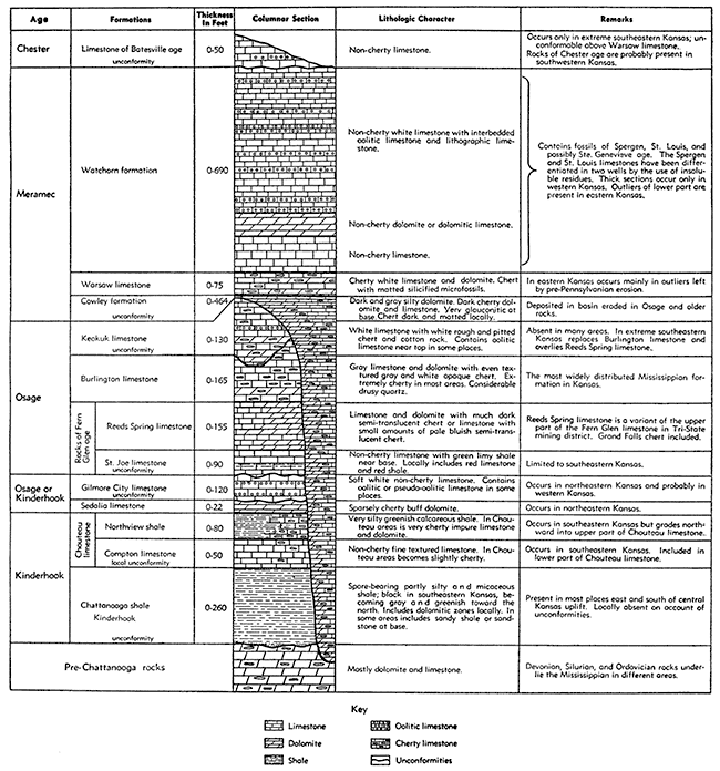
Table 1--Showing stratigraphic units of the subsurface Mississippian rocks in Kansas and their relation to subdivisions made at the outcrops in neighboring states by other geologists.
| State Geological Survey of Kansas | Missouri Bureau of Geology and Mines | Federal Geological Survey | ||
|---|---|---|---|---|
| Subsurface Mississippian rocks of Kansa this report; 1940 |
Southeastern Missouri Stuart Weller and Stuart St. Clair; Geology of Ste. Genevieve Cop., Mo.; Bull. 22, 2nd series, 1928 |
Southwestern Missouri R.C. Moore; Early Mississippian formations of Missouri; Bull. 21, 2nd series, 1928 |
Northeastern Oklahoma, 1939 | Iowa L.R. Louden; Stratigraphy and paleontology of the Gilmore City formation; Univ. of Iowa, Studies in Natural History, Vol. 15, no. 2, 1933 |
| Carboniferous system Pennsylvanian series Unconformity Mississippian series |
Mississippian series | Mississippian series | Carboniferous system Pennsylvanian series Mississippian series |
Mississippian |
| Rocks of Chester age Limestone of Batesville age in Cherokee Co., Kansas Rocks of Chester age are probably present in southwestern Kansas. Unconformity |
Chester group | Fayette shale Limestone of Batesville age in Ottawa Co.; Mayes formation south of Ottawa Co. includes rocks of Batesville and Moorefield age |
Chester Pella Beds |
|
| Rocks of Meramec age Watchorn formation Includes undifferentiated rocks of Spergen, St. Louis and possibly Ste. Genevieve age. Spergen and St. Louis limestones have been identified in the wells by insoluble residues by Miss Hundhausen of the Missouri Geological Survey Warsaw limestone Cowley formation Unconformity |
Meramec group St. Genevieve limestone St. Louis limestone Spergen Warsaw limestone |
Meramec St. Louis limestone Spergen limestone |
||
| Rocks of Osage age Keokuk limestone Burlington limestone Reeds Spring limestone (of Fern Glen age) St. Joe limestone (of Fern Glen age) Unconformity |
Osage group Keokuk limestone Burlington limestone Fern Glen limestone |
Osage group3 Warsaw limestone Keokuk limestone Reeds Spring limestone St. Joe limestone |
Boone formation St. Joe limestone member |
Osage Warsaw limestone Keokuk limestone Burlington limestone |
| Rocks of Kinderhook or Osage age Gilmore City Limestone Unconformity Sedalia limestone |
Kinderhook group Sulphur Springs formation (includes Bushberg ss, Glen Park ls and unnamed shale) |
Kinderhook group4 Northview shale Compton limestone Chattanooga shale Sylamore sandstone |
Kinderhook Gilmore City limestone Hampton formation5 Iowa Falls member Eagle City member Maynes Creek member (Wassonville ls in part6) North Hill member2 English River formation2 Maple Mill shale2 |
|
| Rocks of Kinderhook age Chouteau limestone in northeastern Kansas Northview shale and Compton limestone in southeastern Kansas Unconformity Chattanooga Shale (Kinderhook?) Unconformity |
||||
| Devonian, Silurian, or Ordovician system | Devonian (?) system Chattanooga shale |
Devonian system | ||
|
1. The nomenclature and classification of the subsurface Mississippian rocks of Kansas, as used in this report, accord with usage of the Federal Geological Survey except that the federal survey doubtfully places the Chattanooga shale in the Devonian system 2. Not intended to show correlation with specific formations of other areas 3. Section in Jasper and Lawrence counties, Missouri 4. Section in Dade and Greene counties, Missouri 5. In Stratigraphy of the Kinderhook series of Iowa: Iowa Geological Survey, vol. 35, p. 388, 1929, Lauden placed the Chapin limestone below the Maynes Creek limestone as the lowest member of the Hampton formation. In supplemental statement on the Mississippian of Iowa: Kansas Geological Society Guide Book, Ninth Annual Field Conference, o. 246, 1935, Lauden excluded from the Hampton formation the lower part of the Chapin limestone of north-central Iowa and the North Hill limestone of southeastern Iowa, which he correlated with the Chouteau limestone of Missouri. 6. In Stratigraphy of Kinderhook series of Iowa: Iowa Geological Survey, vol. 35, p. 372, 1929, Lauden refers to the Wassonville limestone of southeastern Iowa as a partial equivalent of the Maynes Creek limestone of north-central Iowa. |
||||
The rocks of Mississippian age in Kansas consist mostly of limestone and dolomite, which contain varying amounts of chert. Some stratigraphic units are noncherty and others contain chert in great abundance. Shale is represented at the base of the section by the Chattanooga shale, as much as 250 feet thick, and by the Northview shale, a thin calcareous silty unit slightly higher in the section. Some shale occurs also in the lower part. of the St. Joe limestone in south-central Kansas. Some dark and very shaly limestones are also present in other formations. Sandstone is conspicuously absent except at the base of the Mississippian, where sandstone or sandy shale is present in many localities at the base of the Chattanooga.
The nomenclature and classification of the subsurface Mississippian rocks of Kansas, as used in this report, accord with usage of the Federal Geological Survey, except that the federal survey doubtfully places the Chattanooga shale in the Devonian system.
The greatest known thickness of Mississippian rocks in Kansas is 1,145 feet in Clark county. The average thickness is about 350 feet, but the thickness varies materially from place to place and is much less than this in many places. Thin sections of Mississippian rocks have been produced as a result of anticlinal movements and base-leveling at the close of the Mississippian. Part of the deformation, however, may have taken place during Mississippian time. Convergence toward the north between certain formations as shown in the cross sections in general is the expression of tilting movements that were taking place during the deposition of the Mississippian.
Rocks of Kinderhook Age
Deposits of Kinderhook age consisting of limestone, dolomite, and shale are widely distributed in the Mississippi Valley. In Kansas the following Kinderhook formations are recognized from the base upward-the Chattanooga shale (doubtfully assigned to Kinderhook), the Compton limestone, and the Northview shale, which together are local equivalents of the Chauteau. The Sedalia and the Gilmore City limestones and intervening formations of Iowa and Missouri are regarded by L. R. Laudon as of Kinderhook age. R. C. Moore, the Missouri Geological Survey, and the Federal Geological Survey place the Sedalia and directly overlying formations in the Osage.Chattanooga Shale (Kinderhook?)
General Statement
The Chattanooga shale is a black to gray shale, which is exposed in many places from Alabama and Georgia to Missouri and Oklahoma, and continues in the subsurface into Kansas. Throughout Tennessee, Kentucky, Missouri, and Arkansas, the Chattanooga is 15 to 50 feet thick in most places, but formations in adjoining states with which it has been correlated are much thicker. There is evidence to indicate its Devonian age in some areas and its Mississippian age in others. Some geologists have concluded that it is composed in part of Devonian and in part of Carboniferous rocks. The State Geological Survey of Kansas doubtfully classes the Chattanooga beds of Kansas as Kinderhook in age, assigning them to the Mississippian series of the Carboniferous system. This shale is conveniently studied with the Mississippian, in any case, for it is separated from the underlying beds by an angular unconformity whereas only an obscure disconformity separates it from the approximately parallel overlying deposits of definite Mississippian age. Its top is the only dependable datum plane below the Pennsylvanian to which beds of Mississippian age may be referred.
The Chattanooga shale was deposited widely in Kansas east of the central Kansas uplift (pl. 3), but it was subsequently removed by erosion in certain areas along the Nemaha ridge, in Cowley and Chautauqua counties cast of the ridge, and in places on the flank of the central Kansas uplift. The shale is generally black in southeastern Kansas where it is in most areas less than 50 feet thick. Toward the north it thickens to more than 250 feet and becomes for the most part gray-green and in places includes some dolomitic and calcareous shale.
Character
The Chattanooga shale in southeastern Kansas is normally a black fissile noncalcareous carbonaceous shale, which is argillaceous in some areas and silty and micaceous in others. It includes considerable fine pyrite, and varying numbers of Sporangites huronensis. These spores, abundant in some places, rare in others, occur throughout the Chattanooga in both black and gray shales. Toward the north, as shown in cross sections A-A' and B-B' of plate 5, the black shale interfingers with lighter gray and green shales and becomes more micaceous. The black color predominates in the southern part of the state, but in Montgomery county a wedge of gray shale starts in the middle of the black shale and gradually expands toward the east until the entire formation consists of gray shale (fig. 2).
Figure 2--Cross section showing relation of black to gray shale in the Chattunooga shale in Montgomery county, Kansas.
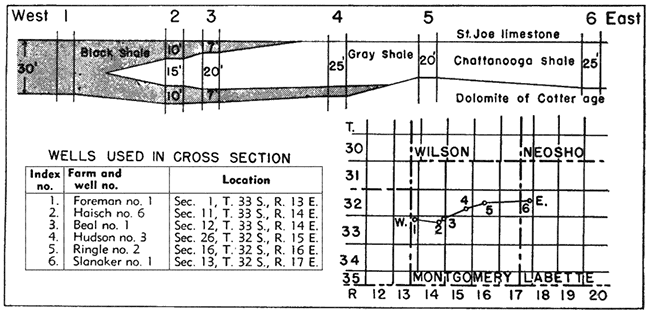
Northward from Cowley county the relation of the black and gray shale is more irregular, the black shale in part grading out to dark shale before interfingering Kith the gray. The dark and black shales are most common at the base of the formation, but are generally absent in the northern and northeastern parts of the state. Black shale is present, however, in some northern areas. Among these are areas in T. 12 S., R. 19 K, in Douglas county where there is 40 feet of calcareous black and dark-green shale near the base of the Chattanooga find in T. 16 S., R. 3 W., in Saline county where 60 feet of black non calcareous, somewhat micaceous shale occurs at the top of the formation.
The attention of the writer was drawn to beds of gray to dark-gray argillaceous shale present at the top of the Chattanooga in many wells in northeastern Kansas by Robert Carmody (oral communication, 1939). These shales differ from the usual type of Chattanooga shale in Kansas by their more argillaceous and less fissile character and by the absence of spores and mica. In some places this shale is slightly silty at its contact with the typical phase of the Chattanooga. It may represent only a lateral variant of the normal section, but in view of the uncertainty concerning the age of the Chattanooga its difference in character and its irregular thickness may have some significance.
In northeastern Kansas where the Chattanooga shale is thick, some parts of it contain impure silty dolomite or dolomitic shale as much as 10 feet thick. A bed of impure dolomite occurs also in Butler county in southern Kansas in the middle part of the black shale, The dolomitic: shales are lenticular in character, having no persistence except v within limited areas, and seem to be local variants of the Chattanooga.
In wells shown in cross section A-A' of plate 5 and cross section D-C' of plate 6 and in other wells in Wabaunsee, Dickinson, Cloud, and Clay counties, shown on the distribution map of the Chattanooga in figure 3, the upper 15 or 20 feet of the Chattanooga is red. In this area the Chattanooga shale seems to have been exposed to weathering during the deposition of the Chouteau before it was buried by younger rocks. The upper 10 feet of shale in a well (Derby No. 1 Neimuller, sec. 19, T. 10 S., R. 3 E., well No. 24 of cross section A-A' of plate 5) in Clay county contains brown ironstone pellets not unlike oolite grains, but flattened and more irregular in shape.
In many places at the base of the Chattanooga, particularly in southeastern Kansas and in the counties east and south of the central Kansas uplift, there is a deposit of sandstone ranging in thickness from a thin streak of sandy shale to clean sandstone several feet thick. This sandstone is irregular in distribution and though widely deposited is only locally more than a few inches thick. In parts of Reno county and in other areas it is thick enough to be an important reservoir rock for oil. It has been well described by Leatherock and Bass (1936, pp. 96-97) and others. It is known as the Misener sand in the subsurface and occupies the position of the Sylamore sandstone of many reports.
Distribution
A map showing the thickness and distribution of the Chattanooga shale is presented in plate 3. The map is based on the examination of well cuttings and of well logs on file July 15, 1938, at the State Geological Survey of Kansas. Most of the logs are from the Kansas Well Log Bureau.
Plate 3--Thickness map of the Chattanooga shale in Kansas. [A larger Acrobat PDF version of this figure is available.]
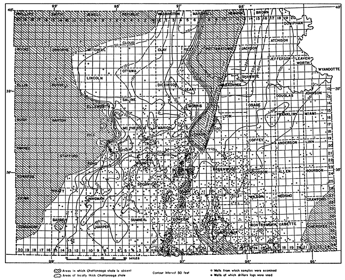
Except for a small area in Ness county not shown in plate 3 or plate 8 the most westerly known occurrence of the Chattanooga shale in Kansas is in western Barber county (Skelly No. 1 Temple well, sec. 13, T. 34 S., R. 15 W.), where it is 52 feet thick. It is absent 40 miles beyond, in eastern Clark county (Watchorn and Olson No. 1 Morrison well, sec. 17, T. 32 S., R. 21 W.), where lower Osage rocks overlie pre-Chattanooga rocks (see cross section F-F' of plate 7). The Chattanooga shale is generally absent north and west of Clark county.
On the southwestern flank of the central Kansas uplift in Barber county and also on its northeastern flank in Lincoln, Russell, and Osborne counties, the Chattanooga shale is overlapped by the Mississippian limestones, which in these areas rest upon pre-Chattanooga rocks. On the southeastern margin of the central Kansas uplift, however, the Chattanooga shale extends west of the present margin of the limestones as shown in plate 8, but here, as elsewhere adjacent to the central Kansas uplift, it is probable that the limestones originally extended beyond the shale. The absence of the Mississippian limestones above the shale in areas on the southeastern margin of the uplift was probably due to post-Mississippian de formation and erosion.
The shale may have been deposited in topographic depressions considerably farther west than is indicated by its present distribution and may still be preserved locally in synclinal areas that escaped the several periods of erosion that occurred during and at the close of Mississippian time. Such an outlier of Chattanooga shale may be represented by greenish-gray shale 16 feet thick containing spores reported by L. R. Fortier (oral communication) at the base of limestone of Burlington age in Ness county (Barnsdall No. 1 Lank well, sec. 35, T. 18 S., R. 21 W., 4,390 to 4,406 feet) on the western flank of the central Kansas uplift. Chattanooga shale is reported to be present also in a few wells in an isolated area shown in plate 3 in T. 17 S., R. 8 W.; in Ellsworth county.
The Chattanooga shale is absent from several large and small areas along the trend of the Nemaha ridge fold. This is due to the fact that after Mississippian deposition was completed the Chattanooga and younger Mississippian rocks were folded and peneplaned. Where the Chattanooga shale was raised above the level of the peneplain the shale, together with the overlying rocks, was worn away, exposing pre-Chattanooga rocks on the crests of many anticlines and domes. The local thinning and absence of the Chattanooga in Sumner, Cowley, and Chautauqua counties are due to post-Keokuk erosion. The area in these counties from which the Chattanooga was removed is also shown roughly in plate 7 within the minus 50-foot thickness line representing the deeper part of the Cowley basin.
There was some erosion of the Chattanooga during Kinderhook time west of the Nemaha ridge in the area of weathered and reddened shales already mentioned, but the amount seems to have been small, for the thin dolomite overlying the weathered surface has a wide distribution. (See cross section D-C' of plate 6.) Also, in southeastern Kansas the Chattanooga surface is so regularly overlain by the thin Compton and Northview formations that the surface in that area must have been essentially flat. In southern Kansas west of the Nemaha ridge the Chattanooga was exposed until the time of the deposition of the St. Joe limestone, but the evidence indicates that this area also was too low to have undergone much erosion.
Thickness
The Chattanooga shale is relatively thin along the Oklahoma border and thickens toward the north. It reaches its maximum known thickness of 260 feet in Washington county in T. 3 S., R. 4 E. It is 245 feet thick in southeastern Nebraska just north of the Kansas-Nebraska border (Kerlyn No. 1 Robin Hood well. ser-. 9, T. 1 N., R. 14 E.; see plate 3). The absence of the Chattanooga due to erosion has already been pointed out. In extreme southeastern Kansas the Chattanooga is absent seemingly because the surface lay above the level of deposition of the shale. On the flanks of the Ozark uplift in Crawford and Cherokee counties the St. Joe limestone rests directly on pre-Chattanooga rocks (St. Louis Smelting and Refining Company, Ballard mine well, sec. 10, T. 35 S., R. 24 E.), probably for the same reason. The Chattanooga is also absent locally in parts of Labette county where the Compton limestone overlies pre-Chattanooga rocks. (Wert No. 1 well, sec. 16, T. 31 S., R. 21 E., and Romine No. 1 well, sec. 30, T. 33 S., R. 21 E.) From Labette county the shale thickens westward along the Oklahoma line and reaches a maximum of 130 feet in Barber county. (Sec. 19, T. 33 S., R. 12 W.) Farther west it becomes thinner, and, near western Comanche county, land formed the western margin of the broad Chattanooga basin. There are only slight variations in the thickness of the Chattanooga in the southern and eastern parts of the region, but in east-central Kansas there are areas of marked thinning. The most prominent of these areas is in Harvey county where the Chattanooga is exceptionally thin. In T. 23 S., R. 2 W., Harvey county, the Chattanooga is less than 15 feet thick and locally absent. The Chattanooga shale thickens in all directions from this township, and 18 miles to the north, in McPherson county, its thickness exceeds 200 feet. In southeastern Saline county the Chattanooga shale thins to less than 100 feet, but thickens again toward the north and east.
In many places in McPherson, Rice, and Reno counties, the Chattanooga shale is known to lie on remnants of Maquoketa shale, whose distribution adapted from McClellan's (1930, p. 1535) pre-Chattanooga areal map is shown in plate 4. In some wells fine sand or sandy shale was found between the two formations. In others, thin remnants of the Hunton separate the Chattanooga and the Maquoketa. The presence of spores, where they are found in the well cuttings, identifies the beds as Chattanooga, but in some wells in McPherson and adjoining counties where no spores have been found, the two formations are so similar that it is difficult to distinguish them even when cuttings are available. The thickness of the Chattanooga (pl. 3), where determined only from well logs, probably includes some unseparated Maquoketa shale in parts of these counties. In many wells in McPherson county, however, spores occur almost to the base of the thickest shale sections. The rapid increase in the thickness of the shale in these areas, therefore, does not seem to be caused so much by the two shales lying in contact with each other, though this also occurs, as by the Chattanooga filling depressions eroded in the Maquoketa shale. L. R. Fortier (oral communication, 1937), of Wichita, also has observed that in parts of McPherson county the Chattanooga shale thickens in broad areas where it replaces the Hunton limestone and parts of the Maquoketa shale.
Stratigraphic relations
The Chattanooga shale is definitely unconformable upon all the underlying formations with which it is in contact. The angular deformation of the older beds, however, is so slight as hardly to be detected in local areas, but regionally the beds underlying the Chattanooga range in age from Ordovician to Devonian.
The Chattanooga was deposited on a peneplaned surface throughout most of the Mississippi valley region. The low relief is indicated by the fact that the Chattanooga deposits, though present almost everywhere in the region, are in most places less than 100 feet thick. In parts of Kansas, however, there seems to have been more local variation in thickness than in most parts of the Mississippi valley region.
An attempt to show the original thickness of the Chattanooga is given on plate 4, which was prepared from plate 3 by omitting areas in which the shale is known to have been removed by postChattanooga erosion. As the upper surface of the Chattanooga was essentially fiat, the map (pl. 4) showing the restoration of the thickness of the shaJe is believed to represent approximately the topography at the base of the Chattanooga. The thickening of the sediments toward the north may indicate northward tilting before or during the deposition of the Chattanooga shale. The fact that this thickening is accompanied by a gradual change in character and color of the shale suggests that the topography, as expressed in the thickness map (pl. 4), was to a large extent original and not caused by later erosion and removal of shale from the southern part of the area.
Plate 4--Sketch map showing generalized topography of pre-Chattanooga surface of eastern Kansas. Map prepared on assumption that top of Chattanooga was essentially a horizontal plane. Contours are adapted from Chattanooga thickness map (pl. 3); variations in thickness of Chattanooga due to pre-Meramec and pre-Pennsylvanian erosion are omitted. Stratigraphic relations of rocks are shown in cross section. Note area of thick Chattanooga shale in old valley in Maquoketa shale in McPherson county, and area of thin Chattanooga shale in Harvey county over outlier of Hunton limestone of oil geologists. Areas where Chattanooga is absent are cross-lined. Stippled areas represent outcrops of Maquoketa shale on pre-Chattanooga surface after Hugh W. McClellan. Contour interval, 50 feet. Datum, top of Chattanooga shale. [A larger Acrobat PDF version of this figure is available.]
The pre-Chattanooga surface, as reconstructed on plate 4, shows the Chattanooga basin not yet divided by uplift along the trend of the subsequently formed Nemaha ridge fold as shown in plate 3. A drainage valley extending northward from Barber county, occupying in part the belt whose surface was underlain by the Maquoketa shale, emptied into a broad valley toward the north.
The relation of the topographic features of the pre-Chattanooga surface, as shown in plate 4, to the areal geology of the time is worthy of comment. The surface had low relief and except for the Maquoketa shale was underlain by hard cherty limestone and some sandstone. The principal valleys were broad and followed the belts of outcrop of the Maquoketa shale on the flanks of the central Kansas uplift and eastward across McPherson county. This shale in the region underlying Geary and Morris counties, where the valley is presumed to have drained into the open basin in northeastern Kansas, was removed by erosion in pre-Pennsylvanian time and the contours on plate 4 are therefore hypothetical where dotted across this area.
The development of parts of the valley, however, seems to have been independent of the areas of the outcropping shale. The area of Hunton limestone centering in Harvey county (pl. 4) was probably separated from the main outcrop of Hunton by an earlier eastward-flowing stream that entrenched the valley in the limestone and subsequently widened it in the underlying Maquoketa shale. Another abnormality is the narrow north-south valley, in Ts. 21 and 22 S., R. 6 W., that cuts across the western end of the Hunton outlier (see pl. 4). This part of the valley was trenched across hard limestone, whereas a belt of Maquoketa shale only a few miles farther west around the west end of the outlier would have provided a more easily eroded channel. The presence of this constricted channel is fully established by cuttings from several wells (pl. 3). Drainage failed to utilize the belt of Maquoketa shale (pl. 4) on the south and east sides of the outlier, probably in part because in Harvey county the Maquoketa shale is in places only 25 feet thick, whereas in Reno and McPherson counties the shale is more than 100 feet thick.
The next younger formation in Kansas, the Chouteau, which is the equivalent of the Compton and the Northview of Kinderhook age, seems to be conformable on the Chattanooga in some areas. The St. Joe and Reeds Spring limestones in some areas are unconformable above the Chattanooga, but, as has been pointed out, not much erosion seems to have occurred during the hiatus. On the southeastern margin of the central Kansas uplift and in places along the Nemaha ridge fold the Pennsylvanian rocks overlie the Chattanooga.
Chouteau Limestone, Northview Shale, and Compton Limestone
The Compton limestone and the Northview shale on the western flank of the Ozarks in west-central and southwestern Missouri were regarded by Moore (1928, pp, 118-127) on faunal grounds, as partial equivalents of the Chouteau limestone, which occupies a corresponding stratigraphic position on the northern flank of the Ozarks. Branson (1938) also regards the Compton and Northview as partial equivalents of the Chouteau. This conclusion, as expressed by Moore and Branson, is confirmed by work on insoluble residues by the Missouri Geological Survey, not yet published, and by the work of the writer on the subsurface rocks of Kansas. These formations are definite lithologic units in their respective areas; and transitional variations from Northview and Compton to Chouteau take place in the intervening area in Kansas.
Compton Limestone and Northview Shale
The Compton limestone was named by Moore (1928, pp. ll8, 122) from outcrops in Webster county in southwestern Missouri, The Northview shale was named by Weller (1901, p. 140). Both these formations are well developed in southwestern Missouri, but they are thin and locally absent in the extreme southwestern corner of the state. Thin local deposits of these formations are reported by Moore (1939, pp. 5 and 6) in outcrops on Grand river in extreme northeastern Oklahoma. Moore (1928) reports a maximum thickness of 25 feet for the Compton at the outcrops in Missouri and 100 feet for the Northview shale.
Outcrops
The Compton limestone at the outcrop is described by Moore as bluish-drab to grayish-blue, compact, very fine-grained limestone that breaks with conchoidal fracture. It contains a few crinoids and other fossils and is 5 to 25 feet thick.
The Northview shale is described as consisting of two members in the outcrops; the upper, a fine-grained yellow sandstone that may be as much as 25 feet thick, the lower, a blue or bluish-green silty shale that is 25 to 75 feet thick.
Branson (1938, pt. 2, pp. 3-5) presents a detailed description of the Northview shale by Jack W. Gardner, who found that the lower shaly part of the formation, as well as the upper part, is really a siltstone composed in many places entirely of fine quartz grains, but with the addition of calcareous and dolomitic cement. The upper sandy member was called by early Missouri geologists the "vermicular sandstone" from the tubular openings in the rock, which resemble worm borings.
Subsurface Character of the Compton Limestone
The limestone from well cuttings in Kansas that is correlated with the Compton is typically a fine-textured, slightly greenish-gray limestone with a waxy luster. It varies in character and in some places is semigranular and crinoidal and gray or pale buff gray. The cuttings ordinarily contain no chert.
The insoluble residues are very small and show only small amounts of white, shapeless, fragile, and spongy siliceous aggregates. As pointed out by Mary Hundhausen and .T. G. Grohskopf of the Missouri Geological Survey (oral communication), the residues include occasional microscopic, white, loose-textured, twisted, siliceous aggregates that suggest casts of worm borings. In most residues, considerable pyrite is present. The residues from the Kansas well samples show similar characteristics.
Subsurface Character of the Northview Shale
The shale that is correlated with the Northview in the Kansas well cuttings resembles, in most places, the lower member of the outcrops. It is gray to greenish-gray, but becomes a darker green in the thicker sections in Allen and Bourbon counties. It is slightly calcareous or dolomitic, the dolomitic character being more prominent toward the area in which the formations are transitional to the Chouteau. The Northview shale does not contain spores as does the underlying Chattanooga shale. The insoluble residues are typically green and porous, and show the silty character bette!' than the original rock.
The upper, more coarsely silty member is generally absent in Kansas or not sufficiently distinctive to be separated. It is present, however, in Allen and Bourbon counties where it is 28 to 33 feet thick. West of Allen county in the Hogueland well in Woodson county (sec. 3, T. 24 S., R. 15 E.; the Compton is 29 feet thick, the Northview 40 feet thick). the Northview is thinner and the upper siltstone member is missing. Toward the north, the siltstone merges into the upper part of the Chouteau.
Thickness of Compton and Northview
The Compton and Northview are both thin near the Oklahoma border but thicken gradually toward the north, where, as shown in cross section C-C' of plate 6, they merge into the lithologically different Chouteau limestone. Eastward along the Oklahoma border from their margin in eastern Chautauqua county, the combined thickness of the Compton and Northview is less than 20 feet in most places. In some wells both formations are drilled through in 5 feet and may be represented in the same sample. The Compton is generally less than half the thickness of the Northview, but in the Marhenke well (sec. 34, T. 25 S., R. 11 E.) in central Greenwood county, the Compton is 10 feet thick and the Northview only 5 feet thick. In this area it is possible that a part of the Northview was eroded before the region was covered by younger rocks.
In southeastern Kansas, although both formations are thin, they maintain their lithological identity and in good sets of samples no difficulty is experienced in distinguishing them. The Compton limestone. because it is soft, yields small samples and there are "skips" in the samples of some wells at the horizon of the Compton, where the limestone is thin.
The maximum thickness of each formation occurs in the Dahl well (sec. 25, T. 26 S., R. 20 E., well No. 4 of cross section C-C', pl. 6) in Allen county near the transition zone where the formations are still distinguishable. In this well the Compton is 28 feet thick and the Northview, including the upper siltstone member, is 61 feet thick.
Transition to Chouteau
In the Dahl well the gray, fine-textured limestone, typical of the Compton farther south, is buff gray and has become brown and lithographic at the top. The Northview is dark-green limy siltstone containing some bands of shaly limestone. The coarse, almost sandy siltstone at the top, which is 6 feet thick, is very dolomitic. In the Briggs well (sec. 15, T. 24 S., R. 21 E., well No. 5 of cross section C-C', pl. 6) in northern Allen county, the typical Northview at the top of the section is only 20 feet thick and overlies brown lithographic limestone and even-textured brown semiopaque chert. Below the lithographic limestone there is a zone of coarse-textured dark-gray limestone, which contains some brown chert. The basal part of the section is gray non cherty limestone, which rests on Chattanooga shale. This part of the section is typical of the Compton in most respects and the residues contain the characteristic spongy aggregates that resemble casts of worm borings. The middle part of the section containing the brown lithographic lin est one and the brown chert resembles neither the Northview nor the Chouteau.
The basal part of the Kinderhook directly overlying the Chattanooga shale in the Leasure No. 5 well (sec. 24, T. 20 S., R. 23 E., well No. 3 of cross section C-C', pl. 6) in Linn county is much like the Compton, but the upper part, though not typical, more closely resembles the Chouteau than the Northview. The upper part of the Chouteau in this well is gray impure dolomite with blocky dull dark-gray chert passing upward into buff and brown dolomite with dull dark-gray chert and brown chert. Some siltstone fragments were noted in the insoluble residues. Farther north, the middle part of the Chouteau contains much brown coarsely sucrose dolomite. The brown chert and lithographic limestone have disappeared and the silt content is smaller.
These wells show clearly the transition from the Compton and Northview to the Chouteau or rather from the Northview to the Chouteau, for the Compton, although it becomes slightly cherty toward the north, maintains its lithologic identity in much of the Chouteau area.
Chouteau Limestone
The term Chouteau limestone, as used by Swallow (1855) in Cooper county, Missouri, was originally applied to rocks including the Sedalia limestone at Sedalia, Mo. Moore (1928, pp. 60, 128) restricted the term to the lower part of Swallow's Chouteau. Some geologists have continued to use the term Chouteau in the original sense. The Chouteau, as restricted by Moore, crops out around the northern flank of the Ozark uplift in Missouri extending from St. Clair county in west-central Missouri to Knox and adjoining counties in northeastern Missouri, and neighboring parts of Illinois and Iowa.
In southeastern Iowa, the lithologically similar North Hill limestone of Laudon is correlated by both Moore (1935, p. 241) and Laudon (1935, p. 246) with the Chouteau limestone of Missouri. In north-central Iowa, Laudon correlates the lower gray limestone ledges of his Chapin limestone with the Chouteau. Moore regards the Chapin as equivalent to the Chouteau.
Outcrops
At the outcrops in west-central Missouri, nearest to Kansas, the Chouteau limestone has been described by Moore and others as light. bluish-gray to dark, drab, compact, dense, earthy to silty impure limestone. It contains layers of dull to gray chert nodules 1 to 4 inches thick.
In northeastern Missouri it has an irregular thickness of 20 to 50 feet. It is absent in some areas north of Missouri river, but reaches a thickness of 50 to 55 feet in Howard and Boone counties in central Missouri. At the outcrops in west central Missouri it is thinner, a maximum thickness of 25 feet having been observed in Benton county. Greater thicknesses for the Chouteau are given by Branson, who includes the Sedalia, Fern Glen, and Reeds Spring in the Chouteau.
Subsurface Character in Kansas
Well cuttings of the Chouteau consist of impure earthy and silty gray and dark-gray limestone containing varying amounts of dolomite and chert. In some beds the dolomite occurs as microscopic crystals in a matrix of silty and siliceous limestone. Other beds consist of porous sucrose dark-gray or buff cherty dolomite not unlike the overlying Sedalia, except. for the abundant chert. In the belt where the Chouteau is transitional to the Northview the dolomite is very coarsely sucrose in some beds. Not much dolomite or chert occurs in the lower 30 feet that corresponds to the Compton.
The chert is of several types. The most characteristic is common throughout the formation. It is ash gray, dull, and opaque, and much of it breaks with a rough surface. Microscopically the chert shows a hard mealy texture with gray matrix between darker gray granules. Another less common type of chert is smooth in fracture, dull-gray opaque or brown semiopaque with stippled markings of lighter color on the fractured surface. The stippled dots seem to have consisted originally of fine silt particles or minute dolomite crystals around which siliceous cement was deposited. Some of the fragments seen in the residues show incomplete coalescence of these growths resulting in a texture microscopically botryoidal. The smoothly fractured stippled chert seems to have resulted from the silicification of the original rock, in which the impurities have become completely merged.
Thickness
The thickest section of the Chouteau noted in wells in Kansas is in the Kasper-James well (sec. 8, T. 13 S., R. 25 E., well No. 7 of cross section C-C' and well No. 8 of cross section D-C', pl. 6) in Johnson county, near Kansas City, where the Chouteau is 111 feet thick. As shown in cross section D-C' of plate 6, its thickness diminishes toward the west until in Wabaunsee county in the Empire-Schwalm well (sec. 19, T. 12 S., R. 11 E., well No. 5 of cross section D-C', pl. 6), the thickness is only 30 feet. Toward the south, as shown in cross section C-C', the combined Northview and Compton thins to 87 feet in the Dahl well (sec. 25, T. 26 S., R. 20 E., well No. 4 of cross section C-C', pl. 6). In the Mary Watt No. 5 well (sec. 34, T. 28 S., R. 17 E., well No. 3 of cross section C-C', pl. 6) in Wilson county, the combined Compton and Northview are only 35 feet thick. Further south on the line of cross section C-C' they thin to less than 5 feet in places and probably disappear a short distance south of the Kansas-Oklahoma border.
Distribution
The distribution of the Northview shale and Compton limestone and of the Chouteau limestone as revealed in well cuttings is shown in plate 8. These rocks are found only east of the Nemaha ridge. As the Mississippian was entirely removed from a broad area on the northern part of the Nemaha ridge, the exact position of the original margin of the Chouteau is uncertain, but the Chouteau is absent west of the denuded area. South of T. 19 S., the Northview and Compton phase of the Chouteau prevails. Some thin outliers of the Compton and Northview may be present in eastern Cowley county.
Stratigraphic Relations
The Chouteau and its correlatives, the Compton and Northview, are underlain by the Chattanooga shale at all places in the subsurface of Kansas except in extreme southeastern Kansas, where the Compton and Northview locally overlap upon pre-Chattanooga rocks. In Webster and Wright counties in southwestern Missouri, Moore (1928, p. 119) noted that the Compton similarly overlaps directly upon the Ordovician. Branson (1938, pt. 1, fig. 8, p. 14) presents a photograph showing the Chouteau overlapping upon Devonian rocks in a quarry near Providence in Boone county, north-central Missouri, with only a thin basal sandstone, which he refers to the Bushberg, intervening. Moore reported other areas in which the Chouteau rests on pre-Chattanooga rocks in northern Missouri. No representative of the Bushberg sandstone or other sand was noted at the base of the Compton or Chouteau of Kansas.
In some areas such as those just noted the Chouteau overlapped beyond the margin of the Chattanooga and is in contact with preChattanooga rocks. In southeastern Kansas, however, the Compton and Northview, correlatives of the Chouteau, are thin, and in Oklahoma they wedge out on the surface of the Chattanooga shale. In northeastern Kansas the Chouteau is not present above the Chattanooga shale west of the Nemaha ridge. It is possible that the sea did not entirely withdraw from the area of Chattanooga deposition and that the Chouteau is conformable upon the Chattanooga in the deeper parts of the Chouteau basin. It seems likely, however, that some slight deformation took place before the deposition of the Chouteau-notably along the Nemaha ridge-causing the Chouteau to overlap beyond the margin of the Chattanooga shale in some places and in others to fall short of covering it.
In southeastern Kansas the Northview is overlain in some places by St. Joe limestone and in others by Reeds Spring limestone or limestones of late Fern Glen age, and the thick series of lower Mississippian rocks in Iowa, known as the Hampton and Gilmore City formations, classified as Kinderhook by Laudon, are absent. There seems, therefore, to be a hiatus between the Northview and the Osage rocks in southeastern Kansas, although the regularity of the Northview and Compton does not seem to indicate much erosion during the interval of exposure, but rather a cessation of deposition.
Farther north in eastern Kansas in a few places the Chouteau is overlain by the Burlington limestone, although in most places a bed of dolomite of possible Sedalia age intervenes. In northern Missouri at the outcrops the rocks overlying the Chouteau and Sedalia are of Burlington age.
Prev Page--Introduction || Next Page--Kinderhook or Osage
Kansas Geological Survey, Geology
Placed on web Jan. 27, 2013; originally published Sept. 1, 1940.
Comments to webadmin@kgs.ku.edu
The URL for this page is http://www.kgs.ku.edu/Publications/Bulletins/33/03_miss.html