![]()
Prev Page--Osage || Next Page--Chester
Mississippian Series, continued
Rocks of Meramec Age
Rocks of Meramec age overlie the Osage rocks at the WI face in parts of Kentucky, Illinois, eastern Missouri, and adjoining states, where they have been subdivided into Warsaw, Spergen, St. Louis, and Ste. Genevieve limestones. Some geologists regard the Warsaw as Osage in age, however. Ste. Genevieve county in southeastern Missouri is the area nearest to Kansas in which the complete Meramec section has been described in detail. The total thickness or the Meramec beds in that area is about 500 feet.
Rocks of Early Meramec Age
In the report on Ste. Genevieve county, Missouri, by Weller anel St. Clair (1928, pp. 193-226) the Warsaw is placed in the Meramec series. Its average thickness in that area is 100 feet. The lower half is composed principally of bluish shale, but includes some ash-colored to grayish-black calcareous shale and streaks and lentils of bluish-gray or grayish-black fine-grained argillaceous limestone. The upper part is composed of limestone, which is for the most part fine-grained, gritty, argillaceous, somewhat magnesian, and siliceous. It is nearly free of chert in some places and moderately cherty in others.
In southwestern Missouri, at Carthage, 50 miles east of the Kansas line, the Warsaw consists of sparsely cherty crinoidal and fossiliferous gray limestone. Microscopic examination of chert collected from the Carthage quarries shows it to be so packed with the silicified remains of microfossils as to have a matted texture. In the Tri-State mining district the Warsaw is more dolomitic and the chert is more abundant and more varied in character than in the outcrops in the Carthage area. Moore (1928, p, 232) reports a probable thickness of about 100 feet in southwestern Missouri. He states that there is "apparently an erosion interval between the time of deposition of the Keokuk and Warsaw beds indicated by basal conglomerates consisting mainly of angular chert at the base of the Warsaw and of solution cavities in the Keokuk filled by limestone and chert fragments cemented in a Warsaw matrix." He concluded on paleontologic grounds, however, that the Warsaw is a part of the Osage series. On account of the very well developed unconformity at the base of rocks assigned to the Warsaw in Kansas, to be discussed, and because of the absence of any evidence of unconformity with the overlying rocks in the subsurface, the writer has included the Warsaw in the Meramec, although faunally the Keokuk and Warsaw are very closely related. Laudon (1939, p. 325) states that, as far as can be determined, there are no rocks in northeastern Oklahoma that are to be correlated with the Warsaw as exposed in the upper Mississippi valley.
Fowler and Lyden (1934, addendum p. 62) report a shaly bed with glauconite at the base of the rocks regarded by them as of Warsaw age in the Tri-State mining district. This shaly bed i generally referred to in the mining district as the J bed; other locally recognized Mississippian units have been designated by them from the top down by letters of the alphabet. The.J bed rests on an irregular surface at the top of the Keokuk. Fowler and Lyden state that within the mining field and several detached areas to the west:
"Erosion cut into the horizontal Keokuk surface before the Warsaw was deposited on it and removed part or all of K and L beds and the upper part of M bed to a total depth of 45 feet below the top of K bed, the top of the Keokuk. J bed is essentially uniform in thickness and character throughout the field and nearly everywhere is an excellent marker horizon. In the area where the underlying beds have been eroded, the section below the normal 4 to 5 feet of J bed down to the old erosion surface is filled with material similar in character to that in the J bed but genera llv more shaly near the base, especially in the deeper places."
The study of well cuttings by the writer indicates that the relief below this unconformity is much greater farther west.
Doubt as to the presence of the Warsaw in the Tri-State mining district has been expressed by some paleontologists. The rocks here assigned to the Warsaw in the subsurface in that district consist of the J bed and the limestones directly above the J bed. Farther west a thick series of silty limestones intervenes between the J bed or glauconitic zone, which is a transgressive basal deposit, and the overlying Warsaw. The Warsaw limestone has distinctive characteristics and can be distinguished from the Keokuk and the Burlington and, aside from the question of its Warsaw age, constitutes a distinct lithologic unit. It was identified as Warsaw by Mary Hundhausen of the Missouri Geological Survey in the Ballard mine well ([earlier in this report]), where it is 70 feet thick exclusive of 20 feet of gray glauconitic limestone at the base reported as the J bed. The lithologic unit reported as Warsaw was also recognized in several other wells examined by Miss Hundhausen, and the usage of Missouri geologists in referring it to the Warsaw will be followed in this report.
Cowley Formation
In southeastern Kansas, the rocks of Osage age are overlain unconformably by thick beds of dark, more or less silty, limestone. As pointed out by Fowler and Lyden, the top of the J bed furnishes a good datum in a considerable part of the Tri-State mining district, but the lower part replaces the uppermost beds of the Keokuk. Toward the west in the southern tier of counties in Kansas, the glauconitic zone cuts progressively deeper into the older Mississippian rocks and is overlain by thick deposits of gray and dark-colored silty, cherty, and dolomitic limestones stratigraphically below the base of the Warsaw. These rocks, together with the glauconitic zone at the base, are here designated the Cowley formation. They constitute the greater part of the Mississippian in parts of Cowley, Chautauqua, and Sumner counties.
The importance of the unconformity at the base of the Cowley formation is shown by the contact of the Cowley in different areas with the Keokuk, Burlington, Reeds Spring, and St. Joe limestones of Osage age. Also, in some places the Cowley rests on the Northview shale, Compton limestone, Chattanooga shale, and even on underlying pre-Chattanooga rocks. At most places in southeastern Kansas it is unconformably overlain by Pennsylvanian rocks, but in some places it is overlain conformably by the Warsaw. In western Kansas no break is recognized between the Cowley and the Warsaw.
North of the southernmost tier of counties in Kansas, the Cowley formation is absent or thin and erratic in distribution. In some places it is represented only by the transgressive silty glauconitic zone, which is regarded under such circumstances as the basal deposit of the Warsaw. The Cowley thickens southward along the Oklahoma line where it is 290 feet thick at one point in southwestern Chautauqua county, 464 feet in southeastern Harper county, 410 feet in central Clark county, and 405 feet in Woods county, Oklahoma. The greater thicknesses may include equivalents of part of the Warsaw.
Definition
The Cowley formation is here named for Cowley county, Kansas, where in most wells, except those in the north-central part of the county, there is a good development of the Cowley formation. In some areas, beds lithologically similar to the Warsaw limestone of the outcrops in Missouri overlie the Cowley. Sets of cuttings from the following wells among many on file at the State Geological Survey show good sections of the Cowley formation: Roxana No. 1 Seacat well, sec. 36, T. 33 S., R. 4 E., 3,215 to 3,465 feet; Roxana No. 1 Vickery well, sec. 7, T. 35 S., R. 3 E., 3,505 to 3,628 feet; Barnsdall No. 1 Black well, sec. 26, T. 34 S., R. 6 E., 2,991 to 3,244 feet.
Oil company warehouses contain many sets of well samples showing the Cowley formation. The Johnson and Shell No. 1 Jarvis well, sec. 19, T. 33 S., R. 6 E., shows cherty white semigranular limestone, probably of Warsaw age, above the Cowley formation, which extends from a depth of 3,117 to 3,396 feet. Other wells showing the Cowley formation are included in the lists of wells accompanying the cross sections.
The Cowley consists of dark or gray limestone containing dark chert, of black to gray silty dolomitic limestone, or of brown dolomite containing large amounts of dark and gray micro fossiliferous chert. Its top is placed at the contact of such beds with white or gray partly semigranular limestones containing gray microfossiliferous chert. In some areas in southwestern Kansas as in well No. 7 of cross section F-F' (pl. 7) rocks with Cowley characteristics extend upward to the base of white semigranular noncherty limestone and may include rocks of Warsaw age. The base of the formation is marked in southeastern Kansas by an accumulation of glauconite at its unconformable contact with older beds.
The dark parts of the Cowley formation have been known vaguely for many years in subsurface work as the "black lime". This term is misleading because the beds are only in part black and only in part limestone. The Cowley is not represented in Missouri, but the J bed of the Warsaw in the Tri-State mining district represents an eastward continuation of the transgressing basal deposit of the Cowley. The Cowley seems to be partly exposed in northeastern Oklahoma where it may be represented by the lower or Moorefield part of the Mayes formation to be discussed later.
Surface at the base of the Cowley formation
A thickness map (pl. 7) with lines drawn at 50-foot intervals has been prepared showing the interval between the base of the Cowley formation and the top of the Chattanooga shale. Only those wells whose cuttings have been examined have been used, except in the area in which the Chattanooga is absent. Drillers' logs, in which no Chattanooga was reported, have been used to outline this area more sharply. Where the base of the Cowley lies below the top of the Chattanooga, the thickness lines are marked by minus signs. In those areas where the Chattanooga has been completely removed, the original position of its top has been determined by using as a datum the base of a semigranular gray limestone that lies near the top of the Cowley formation in parts of Cowley and Chautauqua counties.
As the top of the Chattanooga shale was originally essentially flat, the thickness map (pl. 7) shows the configuration of the surface upon which the Cowley was deposi ted, referred to the top of the Chattanooga shale as a datum plane. Some deformation of the datum plane had taken place prior to Cowley time, but the relief of the pre-Cowley surface is so great and the pre-Cowley warping of the Chattanooga relatively so slight that the surface shown on the map represents the major features of the pre-Cowley erosion surface. Tile absence of any relation between the regional structure of southern Kansas and the thickness of the Cowley formation shows that folding and baseleveling, such as preceded the Chattanooga, did not take place immediately prior to Cowley time.
The pre-Cowley surface in Kansas seems to be the northern part of a large erosion basin lying chiefly in Oklahoma. The region north of Cowley county was a moderately dissected upland without sharp relief, breaking off along a marginal rim to a basin toward the south. The regularity of the contact of the J bed upon the Keokuk in large parts of the Tri-State mining district, pointed out by Fowler and Lyden, is the expression of the relatively small amount of dissection that occurred in parts of the upland area. The topographic relations between the upland area and the basin area to the south were broadly not unlike that of the upland region west of the "flint hills" in Kansas and the topographically lower region lying east of it. In both cases the exposure of cherty limestone helped to preserve the upland area from dissection.
The cross sections A-A', B-B', and C-C' (pIs. 5 and 6) show a well-defined slope with a maximum grade of 40 feet per mile between the basin and the upland areas. In some places thin Cowley rocks or the transgressing glauconitic zone at the base of the Warsaw are present north of the area contoured where they overlap upon the irregularly but not deeply dissected upland surface. The contours show several valleys cutting back into the upland area. The deepest and longest of these valleys lies in Cowley and Butler counties; it must have drained a considerable region of upland to the north. Another well-defined valley is indicated in Sumner and Sedgwick counties west of the position of the Nemaha ridge.
The slope from the basin to tho upland area although not steep is nevertheless well marked in Cowley county and adjacent counties and also in Barber county, as shown in the cross sections (pls. 5 and 7). The exaggerated vertical scale used in the cross sections makes this slope seem much steeper than it actually ls. In the 9 miles between the Skelly-Temple well (sec. 13, T. 34 S., R. 15 W.) and the Sinclair Prairie-Gentry well (sec. 1, T. 33 S., R. 15 W., well No. 8, cross section F-F', pl. 7) the rise toward the north is 150 feet. The slope between the Watchorn and Olson No. 1 Morrison well in Clark county (sec. 17, T. 32 S., R. 21 W., well No. 7, cross section F-F', pl. 7) and the Carter-Everett well in southeast Ford county (sec. 22, T. 29 S., R. 21 W., well No. 6, cross section F-F', pl. 7) is about 250 feet in 18 miles.
The pre-Cowley surface, shown by the contours, deviates from the actual topography by the amount of earlier deformation of the Chattanooga whose top has been used as a datum plane in contouring. Gentle deformation along the axis of the Nemaha ridge has already been noted as taking place during Osage time. The ridge shown in western Cowley county (pl. 7) lies near the Nemaha axis and its position may have been determined by gentle warping along this axis. There had probably been some downward warping also, on the flanks of the central Kansas uplift. The regional tilting toward the south, which was already taking place during Osage time, may have determined the southerly trend of the drainage.
Lithology
A detailed description of the Cow ley deposits has been deferred until after a description of the pre-Cowley topography because the local character of the deposits seems to be closely related to the configuration of the Cowley basin. The beds present a considerable variety of lithologic types, the character of each being determined by its relation to the topography and shore line. Deposits of these various types, however, seem to be contemporaneous, for they grade laterally and interfinger from one to another.
Silty limestone
The most striking and most widely distributed deposits in Kansas are black to gray shaly and very silty limestones. They contain minor but varying amounts of mica, and scattered grains of glauconite in most localities. The deposits have very little chert in some wells and much chert in others. In some localities these deposits are very black and have very little lime. The greater part is dark and calcareous and contains microscopic crystals of dolomite set in a matrix of fine-textured calcareous silty shale. This microscopic texture is distinctive and will be referred to as grainy. Gray dolomitic limestones of grainy texture have been noted sparingly in the Burlington and Keokuk limestones and locally in the Reeds Spring, but these rocks are not shaly or silty. The dark shaly deposits of the Cowley grade upward in some areas into gray or white silty beds, of similar character. In some places the transition from black to light gray is abrupt, in others the change is so gradual that no point of division can be made. This type of the Cowley is distinctly clastic, and much of it is more nearly shale than limestone. In most samples the silty and shaly constituents form so large a part of the rock that cuttings remain coherent and do not crumble when digested in acid. Near the northern margin of the basin chert is rare and mica is a common constituent. In some places the beds are so black and shaly that they have been mistaken for Pennsylvanian or Chattanooga shale, but the microscopic texture and other characteristics are unmistakable. The base of the formation usually consists of black or very dark brown silty beds containing striking amounts of glauconite. On the flank of the basin these beds contain, as an occasional constituent, minute cylindrical particles of pale bluish chert or chalcedony, apparently filling microscopic tubelike voids in the rock.
Except in the area of the open valley in southern Cowley county, the greater part of the formation along the sloping shore of the basin in Kansas as far west as Clark county is of the silty type though there is considerable variation in the amount of clastic material and chert contained in it and a range in color from gray to almost coal black. South of the sloping margin of the basin the shaly and silty deposits have an unbroken thickness exceeding 280 feet in several places (Prairie No. 1 Graham well, sec. 23, T. 32 S., R. 4 E).
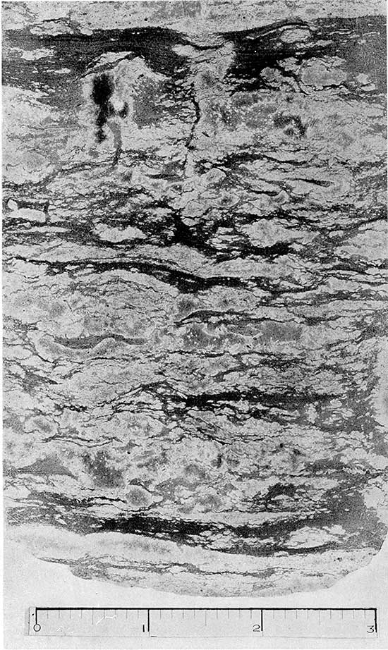
A cherty core 25 feet long that shows this phase of the Cowley was taken from the top of the formation in the Patton Drilling Company No. 1 Rogers well (sec. 35, T. 31 S., R. 2 W.) in Sumner county. A reproduction of a polished section of a part of this core from a depth of 3,852 feet is presented in plate 9 to illustrate the silty beds of the Cowley. The core consist" primarily of finely laminated dark-gray limy, silty shale with much gray chert interrupting the lamination. The core contained no fossils except remains of microorganisms. In some wells in Cowley county the silty limestones are present only in the lower part of the formation, the upper part being of another type yet to be described.
Plate 9--Photograph of polished section of core from upper part of Cowley formation in Patton Drilling Company No. 1 Rogers well, in sec. 35, T. 31 S., R. 2 W., Sumner county, Kansas. The photograph shows the laminated character of the silty limestone. In this core the Cowley contains a much larger proportion of chert (shown by the lighter areas) than is usual. The laminae are shown to be interrupted by the' chert. Both the chert and siltstone are crowded with spicules and t hr- remains of calcareous microorganisms. Photograph is natural size.
In a few Kansas wells, lenses of white semigranular noncherty limestone, rarely more than 10 feet thick, occur in the midst of the dark grainy limestone. These deposits occurring in dark silty limestone seem to have an origin similar to that of clean limestone lenses that are occasionally found in the midst of thick shale deposits. The formation of such lenses may be due to the temporary configuration of the bottom or the direction of currents that provide conditions unfavorable for shale deposition. Only a few wells in the Kansas area show these lenses, but they are more common in the scattered wells examined farther south in Osage county, Oklahoma. These thin white limestone beds generally cannot be correlated from well to well, but one bed, 25 to 55 feet thick, 260 feet above the Chattanooga is somewhat persistent in Cowley county and its base provides a local datum plane within the Cowley formation.
Glauconitic zone
The strongly glauconitic zone generally present at the base of the Cowley is represented in the base of the Warsaw in the Tri-State mining district by the J bed. It is a transgressing basal deposit of the Cowley and Warsaw formations and follows the contact of the Cowley with all the older formations. It is shown on the cross sections as a separate unit although its upper limit is not sharply defined in all wells. It is thickest on the flank of the basin and thins toward the upland area, where in many places it is absent. It also thins toward the south away from the apparent source of the glauconite and silt. In Osage county, Oklahoma, the glauconitic zone is generally not developed although disseminated glauconite is found near the base of the Cowley in some wells. In the National Refining Company No. 4 Sutter well (sec. 1, T. 28 S., R. 6 E.), on the flank of the basin, 55 feet of black silty glauconitic rock at the base of the Warsaw-Cowley sequence was referred to the J bed by Miss Hundhausen, who examined the insoluble residues of this well. In the Prairie No. 9 Brown well (sec. 26. T. 34 S., R. 11 E., well No. 17, cross section F-F', pl. 7) in southern Chautauqua county near the Oklahoma border where the Cowley is in contact with pre-Chattanooga rocks, the glauconitic zone, though very thin, is recognizable in the residues. In the Prairie No. 1 Foster well (sec. 13, T. 34 S., R. 9 E., well No. 16, cross section F-F', pl. 7), also in southern Chautauqua county, the glauconitic zone is in contact with pre-Chattanooga dolomite. It is 7 feet thick in this well and contains at least 25 percent glauconite.
Dark limestone and semitranslucent dark chert
South of the margin of the basin, toward the Oklahoma line in Sumner county, the silty and grainy beds are increasingly interstratified with black. dark-brown, or buff fine-textured limestone. The insoluble residues of the dark limestones are chiefly porous, coherent, earthy aggregates, but are not silty. Opaque black chert and semitranslucent brown chert, not unlike that found in some places in the Reeds Spring, occur in increasing abundance and become darker toward the south, although some streaked and matted gray chert is present in some wells, In the samples examined from wells in Osage county. Oklahoma, the grainy texture is infrequent and the earthy brown and black limestone with much dull semiopaque black chert predominates. Mica and glauconite are much less common constituents than they are farther north.
In the Amerada-Misak well (sec. 25, T. 34 S, R 6 W., well No. 9, cross section F-F', pl. 7) in Harper county, Kansas, many of the Cowley cuttings closely resemble those in Osage county, Oklahoma. The Cowley, which may include some Warsaw at the top, is 469 feet thick in this well. The cuttings consist chiefly of almost black fine-textured dull limestone. The insoluble residues of the limestone are coherent, very porous, dark gray, and earthy. and contain extremely fine casts of dolomite crystals. Grainy silty limestone. however, occurs 230 feet from the top and also in the lower 80 feet, whore there is much brown and almost black splintery semiopaque chert, gray matted chert, and dark glauconitic limestone.
Dolomite and matted chert
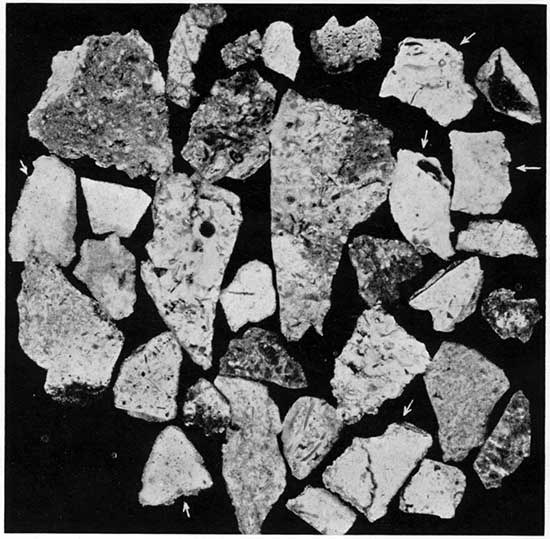
A third lithologic type of the Cowley formation consists of fine sucrose buff and brown dolomite, with which is associated much gray to dark-gray chert, which gives the cuttings a dark-gray color. The chert is distinguished by the silicification of broken microfossils that are present in such quantities as to give much of the chert a matted texture under the microscope (see pl. 10). Much of the chert breaks smoothly, showing outlines of broken minute organisms in contrasting shades of dark gray or black, but some of the chert breaks with a rough fracture and shows the matted microfossils in relief. In some chert the outlines of the microorganisms are blurred, giving the chert a streaked texture of gray and dark gray or brown.
Plate 10--Photomicrograph of polished surface of well cuttings of matted chert from the Warsaw and Cowley formations. The light-colored fragments, indicated by arrows, in which the microfossils are faintly shown by different shades of gray are characteristic of the Warsaw. The fragments showing the microfossils sharply marked by contrasting light and dark chert are from the Cowley formation. Magnification 5.2X.
This type of deposit is best developed in the deepest part of the open valley in Cowley county where almost the entire Cowley formation is composed of it (Prairie No.9 Brown well, sec. 26, T. 34 S., R. 11 E., well No. 17, cross section F-F', pl. 7). In several places, east and west of this valley, this type overlies the dark shaly or grainy type at varying intervals above the Chattanooga. Inasmuch as the contact in some places is sharp it seemed at first that the cherty dolomites might be unconformable on the shaly limestone, but it was later noted that the concentration of glauconite occurs at the contact of either of these types with the pre-Cowley formations but does not occur between them. Near the Oklahoma line there is interfingering of the dolomite and matted chert type with the cherty dark lime type characteristic of the deposits in Osage county, Oklahoma. This interfingering is similar to that observed in Sumner county between the shaly lime and the cherty dark lime. In several wells on the marginal slope of the basin in southwestern Sedgwick county and southeastern Butler county, 5 to 30 feet of the characteristic matted chert occurs in the base of and below the black earthy phase of the Cowley.
These occurrences all lead to the conclusion that the dolomite containing the matted chert deposit is a local variation of the Cowley formation. The occurrence of such thick deposits of this type in the deep valley in Chautauqua county suggests that the accumulation of the microfossils, so abundantly preserved in the chert, is due in some way to the drainage that entered at the head of the embayment while the basin was being filled. The occurrence of this type of chert at the base of the black shaly limestone in some wells along the slope south of the upland and similar chert in the white limestones of Warsaw age above the Cowley, which overlap upon the upland, suggests that the organisms represented in the matted chert found a favorable habitat in the shallow marginal areas of the basin and in the shallow sea that ultimately advanced across the enclosing land area.
White chert
In Ts. 34 and 35 S., Rs. 1 and 2 E., in Sumner county, the samples of five wells show white chert deep in the Mississippian section. The chert consists of opaque gray-white chert and semitranslucent gray chert and some cotton rock. The near-by wells all show thick sections of typical Cowley rocks, which in this locality consist of interbedded rocks of the silty limestone and cherty dark limestone types of the Cowley. The white chert resembles closely the cherts of the Burlington and Keokuk formations, but similar chert occurs also in the Warsaw and overlying rocks in some places. In four of the five wells the white chert lies in the pre-Pennsylvanian zone of weathering, which is very thick, and is unaccompanied by limestone. In one well (Tidal No. 1 McCutcheon well, sec. 33, T. 34 S., R. 2 E.) the weathered zone is 163 feet thick and extends downward to within 70 feet of the top of the Chattanooga. In another well (Mathews No. 1 Berry well, sec. 14, T. 35 S., R. 1 E.) the weathered zone containing the white chert is 150 feet thick and extends to within 35 feet of the top of the Chattanooga. Considerable caving is indicated by the presence of dark shale with the chert. In the Empire No. 1 Hoffman well (sec. 27, T. 34 S., R. 1 E.) the weathered zone at the surface is 95 feet thick. It consists of white opaque chert 50 feet thick overlying 45 feet of dark semiopaque chert and streaked chert commonly found in the Cowley. The calcareous Cowley rocks, below this point, are 193 feet thick. They are exceptionally cherty, consisting almost exclusively of chert, but the lithological characteristics of the chert are normal for the Cowley of this locality except for 45 feet of white opaque chert that contains almost no limestone and lies between 103 and 58 feet above the base. A thin but well-developed glauconitic zone is present at the base of the Cowley section. This is the only well in which white chert occurs within the Cowley formation.
All the wells in which there is an important development of the white chert are on or near the axis of the Nemaha ridge fold, the most sharply defined structural feature in eastern Kansas outside the Tri-State mining district. The close relation between chert deposition and structural deformation in the Tri-State mining district has been pointed out by Fowler and Lyden (1934, p. 28). H. E. Redmon (oral communication) also has noted the increase in the amount of chert toward the crest of anticlinal folds. The writer believes that the development of the white chert in and associated with the Cowley along the Nemaha ridge in this area is related to the deformation of the Nemaha ridge, for the following reasons: (1) The white chert has not been noted in other areas in the Cowley; (2) the area in which it is found has been structurally deformed; (3) it does not appear at the same horizon in near-by wells; and (4) the Cowley rocks also are exceptionally cherty in this locality.
White chert above the Cowley deposits is much thicker in areas bordering the Nemaha ridge fold than elsewhere. Prior to Pennsylvanian sedimentation the area of the Nemaha ridge fold in most areas was raised above the region to the east. If, as seems probable, the ground-water level was simultaneously depressed below the surface of the upraised area conditions were favorable for deep weathering. The great thickness of the weathered zone in this locality may be in part the result of weathering under these conditions and in part the accumulation of residual chert washed into sink holes.
Relation of lithologic types to pre-Cowley topography
The Cowley formation filled the inequalities of the basin eroded in the older rocks. Its upper part and the succeeding conformable Warsaw strata overlapped upon the upland. Silt and earthy material. mica, and glauconite are common near the shore south of the upland area and around the head of the open basin in Cowley county. Chert and earthy limestones occur farther south where the basin was deeper and farther from shore. The cherty dolomitic phase is best developed in the Cowley county embayment. Where the upper part of the Cowley overlaps upon the upland surface, the deposits are thin and in some places consist only of the glauconitic zone. which is included in the lower part of the Warsaw. The deposits of the Cowley formation are overlain by the Warsaw, which consists in most areas of dolomite and semigranular white limestone containing gray matted chert and little or no clastic material.
In Kansas all phases of the Cowley from top to bottom contain scattered grains of glauconite, in which respect it contrasts sharply with the lower Osage deposits in which glauconite is rare. The Keokuk limestones contain some disseminated glauconite in some areas. In southeastern Kansas disseminated glauconite occurs throughout the Cowley but it is infrequent in the Cowley formation in Osage county, Oklahoma, which is farther from the northern shore line of the Cowley basin. In southeastern Kansas there is almost invariably a high concentration of glauconite in the basal beds. Glauconite occurs in the Cowley in western Kansas but is not an important constituent.
Unconformable relation to underlying rocks
A controversy has existed for many years over the relation of the "black lime" to the Osage. One group of geologists has asserted that the "black lime" is merely a lateral variation of the Reeds Spring, Burlington, Keokuk, and Warsaw. Another group contends that the "black lime" rests unconformably on these beds. A paper well presenting the arguments of both sides as to the relation of the "black lime" and the Mayes formation to the Boone formation has been published by Cram (1930, pp. 559-565). There is, of course, much lateral variation in the subdivisions of the Osage, but it is not abrupt and areas of transition are found. Where the dark-colored Cowley formation appears the change is abrupt and the contact with the older rocks, especially in southeastern Kansas, is marked by a concentration of glauconite. There is much variation in the Cowley formation also, but strata of the several lithologic types of the Cowley interfinger with each other in passing from one area to another. No such transition occurs between the white and gray Osage limestones and the dark rocks of the Cowley, though the latter does contain thin lentils of white semigranular noncherty limestone in some places. These white limestones are distinctly local and cannot be traced to the Osage rocks.
In Harvey county, where the Chattanooga is thin or absent over the pre-Chattanooga land (pl. 4) the succeeding Mississippian deposits are typical beds of the Osage series. In Sumner, Cowley, and Chautauqua counties, on the other hand, where the Chattanooga is thin or absent the succeeding beds are very different and consist of beds of one of the types described as Cowley. Where the Chattanooga is absent in these counties these beds are exceptionally thick instead of being thin as would be the case if they overlapped upon land.
The fact that the area of erosion in Cowley and Chautauqua counties, Kansas, is continuous with the so-called "Osage island" of Osage county, Oklahoma, leads to the belief that the absence of the Chattanooga there is due to erosion and not to the presence of land too high to be covered by the Chattanooga sea.
Sphalerite
Cores taken in the Cowley formation in the Kessler and Thier No. 1 Wolfje well (sec. 17, T. 33 S., R. 6 W.) in Harper county at depths of 4,427 and 4,437 feet show a few small crystals of yellow sphalerite. This mineral is in dark shaly dolomite and is associated with dark-blue chert and white calcite crystals. The cores were taken near the top of the Cowley formation at 323 and 333 feet above the Chattanooga. Pennsylvanian shales cap the Cowley unconformably 15 feet above the highest mineralization noted.
Sphalerite was also noted in the rotary cuttings of the Bates-Nimocks well in sec. 16, T. 16 S., R. 28 W., in Lane county at a depth of 4,645 to 4,650 feet in the upper part of the rocks of probable Burlington age, 35 feet below their contact with the upper part of the Meramec, the Cowley being absent. Inasmuch as the well was drilled by rotary tools, the sphalerite may have fallen in from younger rocks higher in the hole.
Warsaw Limestone in the Subsurface
The rocks referred to the Warsaw in the Ballard mine well (sec. 10, T. 35 S., R. 24 E., Cherokee county) by Miss Hundhausen of the Missouri Geological Survey (see p. 46) are 70 feet thick exclusive of the J bed. They consist of gray and gray-white limestone, part of which is fine textured and part semigranular, containing an average of about 50 percent insoluble residues by volume. A few grains of glauconite are present. Much of the insoluble residue is very light and porous find resembles cotton rock. All the chert is gray. Some is dense and opaque and some is semi translucent. A large proportion of the chert is characterized by matted microfossils like the matted chert of the Cowley formation, except that both the silicified microorganisms and the matrix are gray (see pl. 10).
In some zones the microfossils are not silicified and the insoluble residues consist of soft cotton rock, rough opaque chert or semiopaque glazed chert, with molds from which the calcareous microorganisms have been removed by the acid. The molds left in the glazed chert are partly lined with minutely drusy quartz crystals. All combinations of these characteristics occur. Some of the residues that resemble cotton rock are white and firm. The crowded fossil fragments in some zones farther north are crinoidal and coarser than is typical of the matted chert. The semi granular crinoidal and only slightly cherty character of the outcrops at Carthage, Mo., has been noted. Similar slightly cherty or noncherty limestones occur in some places above the Cowley west and north of the Tri-State mining district. The Warsaw rocks in tho Kasper-James well (sec. 8, T. 13 S., R. 25 E., residues examined by the Missouri Geological Survey; see [later in this report]) in Johnson county are 75 feet thick. The limestone is more crinoidal than in the Ballard mine well. The chert is denser and in some zones the matted chert is coarse and includes small silicified crinoid sterns. Some detached crinoid stems in the residues are covered with a crust of white chalcedony. In some of the more coarsely matted chert, the fossil fragments are brown and buff with some semi translucent buff chert. In the upper part, some of the cavities, revealed in the insoluble residues, are lined with columnar and mammillary crusts of buff chalcedony. In northern McPherson county (Archer No. 1 Templin well, sec. 32, T. 17 S., R. 3 W., well No. 19, cross section A-A', pl. 5) and southern Saline county (Brouk et al. No. 1 Thelander well, sec. 10, T. 16 S., R. 3 W., well No. 20, cross section A-A', pl. 5) the insoluble residues of the uppermost part of the rocks referred to Warsaw consist of spongy aggregations of loose spicules, which may belong to the overlying less cherty limestones characteristic of the Spergen. Where the rocks are crinoidal and not very siliceous, drusy crusts similar to those in the Spergen constitute a part of the small residue.
In Scott county the Warsaw is 75 feet thick in the Watchorn and McNeeley-Spangler well (sec. 23, T. 20 S., R. 33 W., residues examined by the Missouri Geological Survey, see [later in this report]). The limestone is chiefly cherty semigranular gray limestone, but contains 20 feet of silty dolomitic limestone, like the Cowley, 15 feet below the top. Most of the chert is matted. In the insoluble residues, the microorganisms are in part represented by molds in the chert, but some of the chert is dense. Most of the chert is light colored, but there are some fragments showing dark markings. The residues of the zone of silty dolomitic limestone near the top are similar to tile residues obtained from the silty phase of the Cowley, but because these rocks immediately underlie beds tentatively referred to tho Spergen and have Cowley characteristics only in part, they are assigned to the Warsaw.
Thickness
No locality is known where well-defined Warsaw is in contact with both the Cowley below and the Spergen or upper Warsaw above. In the Kasper-James well in Johnson county the thickness of the Warsaw is 75 feet, but there the Cowley formation is absent. In most places the thickness of the Warsaw has beer; reduced by post-Mississippian erosion. In western Kansas, wells Nos. 6, 7, and 9 probably lay too near the margin of the confining basin for the seas to become dear as in eastern Kansas so that ill these places the Warsaw continued to receive silt and shale. An uninterrupted thickness of Warsaw probably is present in this area beneath the Spergen, but as no definable break separates the Warsaw from the Cowley the thickness of the Warsaw is uncertain.
Distribution
The Warsaw is widely distributed in eastern Kansas, but on account of the unconformity at its base north of the Cowley basin and on account of the pre-Pennsylvanian peneplanation, which completely removed it in many areas, its distribution is extremely erratic and unpredictable. It seems not to have been deposited in southeastern Logan county (Alma and McNeeley No. 1 Watchorn well, sec, 13, T. 15 S., R. 33 W., well No. 2, cross section F-F', pl. 7) nor north and northwest of this county. It is probably present in southwestern Kansas, but not in areas bordering the central Kansas uplift, for it is absent in northern Lane county (Bates No. 1 Nimock well, sec. 16, T. 16 S., R. 28 W., well No. 24 inset in cross section F-F', pl. 7) where upper Meramec rocks overlap upon representatives of the Osage.
Stratigraphic relations
The Warsaw seems to be conformable above the Cowley and conformable below younger Meramec rocks. In southeastern Kansas the Cowley formation is chiefly a dark-colored finely clastic deposit, confined more or less closely by the margin of the basin contoured in plate 7. When the slightly dissected upland surface north of the basin was submerged the shore line must have receded rapidly, allowing the deposition of limestone relatively free of silt and mud. The transition from Cowley to Warsaw seems to be the expression of the clearing of the seas. On account of the more rapid advance of the sea across the relatively flat upland surface, the glauconitic zone at the base of the Warsaw was generally not developed in east-central and northeastern Kansas. When limestones free of silt and mud were being deposited in southeastern Kansas, the areas nearer the shore line were probably still receiving silt. Cross section F-F' (pl. 7) shows that the Spangler well (sec. 23, T. 20 S., R. 33 W.) in Scott county (well No. 3) was not far from the margin of Warsaw sedimentation. Its nearness to the shore may explain the presence of silty deposits in the Warsaw. The transition from silty to relatively clean limestones probably took place earlier in some areas than others so that the boundary between the Warsaw and the Cowley is probably transgressive. Although the contact between the Warsaw and the Cowley seems to be conformable, the Warsaw is unconformable upon the relatively level surface underlain by Burlington and Keokuk limestones.
Rocks of Late Meramec Age
Outcrops
The nearest extensive outcrops of the rocks of late Meramec age are in Ste. Genevieve county in southeastern Missouri, where the Spergen, St. Louis, and Ste. Genevieve limestones were described by Weller and St. Clair (1928, pp. 193-226). The Spergen limestone in that area is 160 feet thick. Its character varies from light-gray or white oolite to white crystalline limestone, nearly or quite free of chert. It is very fossiliferous. The overlying St. Louis limestone is approximately 160 feet thick in Ste. Genevieve county. It is composed of light-gray to bluish compact dense limestone; some beds are lithographic in texture, Locally some of the beds contain buff dolomite. In some parts there is considerable gray and black chert in definite but discontinuous horizontal bands. The Ste. Genevieve is separated from the St. Louis by a not very pronounced unconformity and ranges in thickness from 60 to 100 feet. It is composed of sparsely oolitic and arenaceous cross-bedded, commonly white limestones. The beds exhibit considerable diversity and locally are shaly. Toward the top horizontally bedded crystalline limestone includes red chert, and locally some fine-grained brown sandstone lenses are present.
An outcrop of St. Louis limestone extending over an area of about 200 square miles was discovered by Clark (1937) in Dade county in southwestern Missouri where it has been preserved by faulting. The limestone varies in color from light gray to dark and in texture from dense lithographic to coarse-grained crinoidal limestone. Some layers are oolitic and some are conglomeratic with limestone pebbles in a limestone matrix. Massive, spongy and tripoli tic chert and seams and bands of dense light blue-gray chert are present. Its stratigraphic relation to the underlying beds is not determinable. The maximum thickness exposed is 40 feet.
Subsurface formations in Kansas
The Meramec rocks above the cherty limestones of Warsaw age in Kansas consist mainly of crinoidal semigranular limestones with very little chert. They contain some oolitic and fossiliferous beds and a well-defined dolomitic zone is generally present in the lower part. In southwestern Kansas these rocks probably have a very general distribution, but in eastern Kansas they are present only locally beneath the pre-Pennsylvanian unconformity.
The Missouri Geological Survey, by means of insoluble residues, has subdivided these rocks into the Spergen (Salem of some classifications) limestone and St. Louis limestone in two widely separated wells, one in Johnson county in northeastern Kansas and the other in Scott county in western Kansas. The criteria used were worked out in Missouri where the rocks have a more general distribution in the subsurface and are nearer the outcrops than in Kansas. The Mississippian formations in these wells identified by Mary Hundhausen are summarized below according to the classification used in this report.
| Summary of Mississippian Formations from Residue Analyses of Cuttings from the Kasper No. 1 James Well, Johnson County, Kansas, sec. 8, T. 13 S., R. 25 E. | Thickness, feet |
Total depth, feet |
|||
|---|---|---|---|---|---|
| Carboniferous system: | |||||
| No samples | 740 | 740 | |||
| Mississippian series: | |||||
| Rocks of Meramec age | |||||
| St. Louis limestone | 50 | 790 | |||
| Spergen limestone | 50 | 840 | |||
| Warsaw limestone | 75 | 915 | |||
| Rocks of Osage age | |||||
| * Burlington and Keokuk, undivided | 145 | 1,060 | |||
| † Rocks of Kinderhook or Osage age | |||||
| Sedalia limestone | 30 | 1,090 | |||
| Rocks of Kinderhook age | |||||
| Chouteau limestone | 115 | 1,205 | |||
| Chattanooga shale (Kinderhook?) | 14 | 1,219 | |||
| Devonian system | |||||
| *The cherts of this interval are tentatively referred to the Burlington by the writer. † Classification by Wallace Lee. |
|||||
| Summary of Mississippian Formations from Residue Analyses of Cuttings from the Watchorn and McNeeley No. 1 Spangler Well, Scott County, Kansas, sec. 23, T. 20 S., R: 33 W. | Thickness, feet |
Total depth, feet |
||||
|---|---|---|---|---|---|---|
| Carboniferous system: | ||||||
| No samples | 4,810 | 4,810 | ||||
| Mississippian series: | ||||||
| Rocks of Meramec age | ||||||
| St. Louis limestone | 50 | 4,860 | ||||
| * Spergen limestone | 140 | 5,000 | ||||
| Warsaw limestone | 69 | 5.069 | ||||
| Rocks of Osage age | ||||||
| Burlington and Keokuk, undivided | 101 | 5.l70 | ||||
| † Rocks of Kinderhook or Osage age | ||||||
| Oolitic limestone, possible equivalent of the Gilmore City of Iowa | 110 | 5,280 | ||||
| No samples | 15 | 5,295 | ||||
| Silurian (?) system | ||||||
| * The dolomite limestone member of the Watchorn formation lies between 4,933 and 4,998 feet below the surface and is a part of the Spergen as here determined. † Classification by Wallace Lee. |
||||||
McQueen and Greene (1938, p. 31) have expressed hesitancy in identifying the Spergen in the cuttings of wells in northwestern Missouri and have provisionally referred the rocks immediately above the cherty Warsaw in northwestern Missouri to the upper Warsaw. Girty found fossils in cores from wells in western Kansas that led him to refer to certain cores as of probable Spergen age (see Girty's accompanying report on Watchorn No. 2 Morrison well). Approximately the same zones were originally correlated as Spergen by Miss Hundhausen of the Missouri Geological Survey. They will therefore be discussed herein as of tentative Spergen age.
In the Kasper-James well in Johnson county, the Spergen or upper Warsaw, as it is referred to by the Missouri Geological Survey (McQucen and Greene, 1938, p. 31) in northwestern Missouri, is represented by 50 feet of semigranular buff and gray limestone. It contains very little chert, but some semiopaque red chert is present in the upper and lower parts. Some oolites seem to be present and some reddish and greenish calcareous shale occurs near the base. The insoluble residues are small and consist chiefly of brownish drusy sugary crusts that originally must have lined microscopic pockets in the limestone.
In the Spangler well 140 feet of rock was identified as Spergen. The upper part consists of buff fossiliferous limestone and oolitic limestone with a fine-textured limestone matrix. The lower 75 feet is similar, but the matrix consists of buff dolomite. Some specimens of the foraminifer Endothyra occur in the middle part of the section. The residues of some zones contain some bluish hackly semiopaque chert showing silicification of coarse aggregates of crowded broken fossils. No red chert is present. Most of the residues are small, but show abundant brown drusy crusts originally lining voids in the limestone, but some of the crusts cover crinoid joints and other fossil fragments. Some of the drusy crusts are gray or chaloedonic.
The limestone identified as St. Louis in the Kasper-James well in Johnson county is 50 feet thick and consists of fine-textured and lithographic limestone and some crystalline limestone. Some sand seems to be occluded in the limestone. In some zones there are virtually no insoluble residues, but some samples from the uppermost and middle parts yield chert with blurred gray silicified fossil fragments in a gray almost glassy translucent matrix. Some opaque white chert similar to the matted chert of the Warsaw is present, but the microscopic organisms are in part bordered by thin gray glassy silica, In the Spangler well in Scott county the limestone similar to that referred to the St. Louis in the Kasper-James well contains fossils definitely identified by Girty as St. Louis although no limits were set. The grayish-buff limestone is not very fine-textured, however, and contains little if any lithographic limestone. The limestone consists mainly of finely broken fragments of fossils and some oolites in a fine-textured matrix. The residues are very small and consist mainly of the gray translucent silica enclosing gray opaque fossil fragments such as characterize the St. Louis in Johnson county.
Watchorn Formation
Definition
In western Kansas very few residues have been available for examination and the separation of the thick sequence of limestones above the Warsaw is dependent on residues. The term Watchorn formation is here applied as a convenient subsurface lithologic term where the subdivision of this sequence of strata into the Spergen, St. Louis, and possibly Ste. Genevieve limestones is impracticable. The formation consists essentially of these limestones. The Watchorn formation is well developed in southwestern Kansas, but, except for a few localities where the lower beds may be present, it has been eroded from the region east of the central Kansas uplift.
The Watchorn formation was first penetrated in western Kansas in Clark county in 1931 in the Watchorn Oil and Gas Company No. 2 Morrison well, in the NE NW sec. 20, T. 32 S., R. 21 W. Many cores were taken during the drilling of the well, but only a few samples, saved by James I. Daniels for the Continental Oil Company, could be located. In 1936 the Watchorn Oil and Gas Company and Olson Drilling Company drilled No. 1 Morrison, a producing well, in the SE SW sec. 17, of the same township, offsetting the original deep well. The limestones in this well that overlie with apparent conformity the undivided Cowley and Warsaw formations and that unconformably underlie the Pennsylvanian rocks are herein termed the Watchorn formation, named for the company that drilled the first well that penetrated these rocks in Kansas. The Watchorn and Olson No. 1 Morrison well, in the SE SW sec. 17, T. 32 S., R. 21 W., is the type locality. The formation extends from a depth of 5,330 feet to 6,020 feet and is 690 feet thick in this well. Samples from this well are on file at the State Geological Survey of Kansas at Lawrence, and at the geological department of the Municipal University of Wichita. Fossils obtained from the cores of Watchorn Oil and Gas Company No. 2 Morrison well, in sec. 20, T. 32 S., R. 21 W., were examined by G. H. Girty, and his discussion of them is given in another section of this report. They indicate the Meramec age (probably Spergen and Warsaw) of the lower 268 feet from which fossiliferous core samples are available. No fossils or cores from the upper 359 feet of the Mississippian of this well were available.
It is probable that the St. Louis and the Ste. Genevieve limestones are represented above the cores examined by Girty. Fossils of Warsaw and Spergen age have been identified from cores collected from several other wells in western Kansas. Limestone of definite St. Louis age is present in the Atlantic No. 1-A Mark well in Scott county.
Roth (McClellan, 1930, p. 1548; confirmed by Roth, letter to the writer, June 8, 1938), who examined the cores and cuttings from the No. 2 Morrison well at the time it was drilled, reported that fossils of Chester age are present in the upper part of this well, but made no record of the fossils nor the depths from which they were obtained. If Chester rocks are present and can be differentiated it is not intended to include them in the Watchorn formation. Where Chester rocks are absent the Watchorn is unconformably overlain by Pennsylvanian strata.
Description
In Watchorn and Olson No. 1 Morrison, tile Watchorn has three lithologically separable units; at the base, a member 120 feet. thick, consisting of noncherty or only sparsely cherty semigranular gray limestone; in the middle, a member 25 feet thick, consisting of buff sucrose dolomite containing some dull and semitranslucent gray chert; and at the top, a member 545 feet thick, consisting of semigranular gray and white limestone. The dolomitic zone in the Watchorn and McNeeley-Spangler well, [see earlier in this report], is there included in the Spergen. The matrix of some of the semigranular limestone beds of the uppermost member is finely sucrose gray dolomite. The whole member shows bands of oolitic limestone 5 to 15 feet thick at intervals of 20 to 80 feet. Some of the beds, as shown by the cuttings, are extremely fossiliferous. In some wells, notably in Scott county, thin beds of lithographic limestone are present in the upper part, probably indicating the St. Louis. In some wells also rounded grains of sand occur with oolites and rounded shell fragments enclosed in the same matrix. In the Watchorn and Olson No. 2 well, these sandy oolitic limestones occur between 420 and 480 feet above the top of the Warsaw.
The Watchorn as a whole is non cherty, but minor amounts of dull and semitranslucent gray chert are present in some beds. As nearly nil the samples examined from western Kansas are from a few rotary wells, it was not determined whether the chert is confined to certain zones that might be useful datum planes. Glauconite is sparsely and erratically disseminated throughout the Watchorn.
Watchorn Formation in eastern Kansas
The dolomite member of the Watchorn and the underlying basal semigranular limestone are present in several scattered wells east of the central Kansas uplift, but the dolomite becomes less prominent northeastward and is absent in Johnson county. In the Hammond et al. No. 1 Roeder well (sec. 23, T. 27 S., R. 2 W., well No.9, cross section A-A', pl. 5) in Sedgwick county, 20 feet of noncherty semigranular limestone rests on cherty Warsaw limestone. Farther north in Sedgwick county in the Kayser No. 1 Stroot well (sec. 8, T. 26 S., R. 2 W., well No. 11, cross section A-A', pl. 5), 50 feet of similar limestone overlies the Warsaw. In the Hawkins No. 1 Marshall well (sec. 4, T. 25 S., R. 2 W., well No. 12, cross section A-A', pl. 5) the cherty limestones assigned to the Warsaw are only 15 feet thick. They are overlain by 40 feet of noncherty semigranular limestone and 55 feet of gray almost noncherty dolomite. In McPherson county in the Curley No. 1 Johnson well (sec. 17, T. 18 S., R. 2 W.) the cherty Warsaw limestones are absent and 10 feet of noncherty limestone overlies the Keokuk. The noncherty limestone is overlain by 35 feet of gray dolomite with which some pink semi translucent chert is associated. The dolomite is overlain by 40 feet of gray semigranular limestone. In the Brouk et al. No. 1 Thelander well (sec. 10, T. 16 S., R. 3 W., well No. 20, cross section A-A', pl. 5) in Saline county, gray dolomite, 40 feet thick, at the top of the section overlies 40 feet of siliceous dolomite and limestone with residues of gray chert containing casts of dolomite crystals. This limestone does not have Warsaw characteristics but may represent a. cherty marginal phase of the non cherty limestone of the Warsaw usually present directly below the dolomite, for it rests directly on the Keokuk. In Lyon county (well on Runyan farm, sec. 9, T. 17 S., R. 10 E., well No. 13, cross section B-B', pl. 5) scattered samples in the upper 100 feet of the Mississippian section show the presence of non cherty limestone above noncherty dolomite. They probably represent parts of the Watchorn formation, for clear drusy crusts occur in the residues. In Wabaunsee county (Empire No. 1 Schwalm well, sec. 19, T. 12 S., R. 11 E., well No. 14, cross section B-B', pl. 5) a noncherty dolomitic zone, 66 feet thick, directly overlies cherty dolomite like that in the Brouk-Thelander well with very feeble development of Warsaw characteristics. No typical Warsaw is present below these rocks, which overlie the Burlington.
Watchorn formation in western Kansas
The Morrison field in Clark county at present provides the only tie between the Mississippian beds in western Kansas and the better known sections east of the central Kansas uplift. In this field no Chattanooga shale is present though it is 45 feet thick in the Sinclair No. 1 Stewart well in sec. 33, T. 27 S., R. 16 W., in Woods county, Oklahoma, 20 miles south, and 52 feet thick in the Skelly No. 1 Temple well (No. 8 of cross section F-F', pl. 7) in Harper county, Kansas, 40 miles east. In the Watchorn and Olson No. 1 Morrison well (No. 7 of cross section F-F'), 45 feet of St. Joe limestone, consisting of 30 feet of gray shale at the top and 15 feet of limestone at the base, unconformably overlies pre-Chattanooga rocks. It unconformably underlies the Cowley formation, which, possibly including undivided Warsaw, is 410 feet thick. The overlying basal noncherty semigranular limestone member of the Watchorn, here almost free of chert, is 120 feet thick. This limestone is overlain by approximately 25 feet of moderately cherty sucrose buff dolomite similar to that observed above semigranular limestone in Sedgwick county. The section up to this point is similar to that observed in a few wells east of the central Kansas uplift. The highest member of the Watchorn consists of 545 feet of white granular limestone, characterized by numerous beds of oolite and rolled grains of fossil fragment and beds of fossiliferous limestone. Some of the oolite beds contain scattered well-rounded frosted sand grains imbedded in the limestone. The Watchorn includes some beds of lithographic limestone and contains very little chert. The entire thickness of this sequence of rocks is rarely represented in Kansas east of the central Kansas uplift, though as already mentioned the basal rocks of this formation have survived the pre-Pennsylvanian erosion in some places.
Most of the wells drilled through the Watchorn in western Kansas were drilled with rotary tools and consequently do not yield very satisfactory material for subdividing the formations, though units already determined from cuttings of standard tools elsewhere in the region can usually be recognized. On this account, and because relatively few wells have been drilled through the Watchorn, no subdivisions of the upper member of the Watchorn have been made. Eventually the lithographic limestone and some of the fossiliferous zones, particularly those containing Endothyra reported by Girty as prominent in the Spergen, may prove to be important markers.
Age of the Watchorn formation
Through the cooperation of the Atlantic Refining Company, the Continental Oil Company, the Carter Oil Company, the Skelly Oil Company, and the Magnolia Petroleum Company, and the Geological Department of the Municipal University of Wichita, several sets of fossiliferous cores were assembled and submitted to George H. Girty of the United States Geological Survey, whose report is attached. From this report it seems that the uppermost zone of the Cowley and the lower zones of the Watchorn up to the top of the dolomitic zone are "of probable Warsaw age". This is followed by beds conservatively reported as "probably Spergen in age" up to about 160 feet above the top of this dolomite member. Some fossils of definite St. Louis age were noted in the Atlantic No. 1-A Mark well (No. 2, cross section F-F', pl. 7), but the limits of the formation are not determinable by faunal content. The wells from which most of the cores were taken are shown on cross section F-F', plate 7. In the Watchorn No. 2 Morrison well (No. 7a, cross section F-F'), 359 feet of limestone occurs above the highest beds whose age has been determined. The basal part of this zone corresponds in stratigraphic position to the zone determined as at least in part of St. Louis age in the Atlantic No. 1-A Mark well in Scott county (No. 3a, in cross section F-F'). Girty noted some evidence that beds of Ste. Genevieve age are present above the St. Louis in the Atlantic No. 1-A Mark well in Scott county, sec. 28, T. 20 S., R. 33 W. (well No. 3a, cross section F-F') . No rocks of Chester age were definitely identified in the cores. The results of the paleontologic examination indicate that those parts of the Watchorn formation from which fossiliferous cores are available are above the Warsaw, although the lower part of the noncherty limestone of the Spangler well is reported as of probable Warsaw age. Since the examination of the cores by Girty, specimens of Endothyra have been found in some of the samples from this zone that would suggest a probable or possible Spergen age for at least a part of these rocks.
The residues examined by Miss Hundhausen, of the Missouri Geological Survey, indicate that the dolomite and the non cherty limestones to 67 feet above the top of the dolomite are of Spergen age, and the rest, as far as samples were available (50 feet), is of St. Louis age. Both fossils and residues are in agreement that the upper part of the Watchorn in this area includes beds of St. Louis age. The oolitic limestone at the top of the Atlantic No. 1-A Mark well cores, regarded by Girty as of possible Ste. Genevieve age, was not represented in the cuttings of the Spangler well.
Some discrepancies occur between the identifications by means of fossils from the well cores and those made by siliceous residues. The reports are, however, not necessarily in disagreement, for the scanty faunal evidence does not indicate the divisions so sharply as the residue criteria, and in view of the small number of fossils that were recovered from the cores the results are essentially harmonious.
Prev Page--Osage || Next Page--Chester
Kansas Geological Survey, Geology
Placed on web Jan. 27, 2013; originally published Sept. 1, 1940.
Comments to webadmin@kgs.ku.edu
The URL for this page is http://www.kgs.ku.edu/Publications/Bulletins/33/06_mera.html