![]()
Prev Page--Chester || Next Page--Fossils
Cross Section in Western Kansas
In the preceding chapters discussion is devoted chiefly to the Mississippian rocks in central and eastern Kansas, where they have been penetrated by thousands of wells; and frequent reference has been made to the several detailed cross sections for those portions of the state. Inasmuch as little has been said thus far in regard to the stratigraphic relations of the rocks in western Kansas, where they have been penetrated by only a few wells, a brief discussion of their relations, as revealed in that part of the state by cross section F-F', plate 7, is here given. The column of Mississippian rock in 'western Kansas differs from that in eastern Kansas by including at the top a greater thickness of the Watchorn formation, which is incompletely and only locally represented in eastern Kansas. The Chattanooga shale, which provides a convenient datum in other parts of the state, is generally absent in western Kansas.
The wells in cross section F-F' are correlated on the top of the Chattanooga shale east of Clark county in wells 8 to 22. From Clark county northwestward the contact of the Watchorn formation with the cherty Warsaw limestone has been used as a datum in wells 3 to 7. In wells 1 and 2, where the Warsaw is absent, the wells have been correlated on the top of the Burlington. The correlation of the Watchorn and Olson No. 1 Morrison well in Clark county (No. 7 of the cross section) with the Skelly No. 1 Temple well in Barber county (well No. 8 of the cross section) is the link that connects the Mississippian rocks of eastern Kansas with those of the western part of the state. In both these wells the green limy shale member of the St. Joe limestone is present. In the Skelly No. 1 Temple well (well No. 8) the St. Joe limestone is underlain by the Chattanooga shale, but in the Watchorn and Olson No. 1 Morrison well (well No. 7) the shale member of the St. Joe overlaps upon the pre-Chattanooga rocks.
In the Watchorn and Olson No. 1 Morrison well (well No. 7), the base of the Cowley formation lies 45 feet above the base of the Mississippian section, but 18 miles north, in the Carter No. 1 Everett well (well No. 6), the surface of the Osage rocks was not eroded so deeply in pre-Cowley time, for 110 feet of limestone identified as Burlington and 126 feet of rocks of Fern Glen age are present below the Cowley. In the Cartel No. 1 Everett well (well No. 6) the rocks of lower Osage age include 2 feet of shale of the St. Joe and 12 feet of St. Joe limestone at the base and 40 feet of dense noncherty green and red lithographic limestone at the top. The only other well in which lithographic limestone of similar character was observed is well No. 8, in which lithographic limestone 8 feet thick is present in rocks of Fern Glen age directly below the Cowley. Undivided Warsaw and Cowley rocks 180 feet thick occur above the Burlington in the Carter No. 1 Everett well (well No. 6). The Watchorn and Olson No. 1 Morrison well (well No. 7) to the south has 410 feet of similar rocks but the Swain-Taylor well (well No. 5) 24 miles north has no Cowley and only 44 feet of Warsaw overlying the Burlington. The Carter No. 1 Everett well (well No. 6) therefore seems to be near the margin of the pre-Cowley upland, for Osage strata, which farther south were almost completely eroded, were only partly removed by pre-Cowley erosion.
The area in which the Swain-Taylor well (well No. 5) was drilled did not receive deposits of Fern Glen age. It seems to have been covered by the Gilmore City rocks and was overlapped by the Burlington in the same way as the area northeast of the central Kansas uplift. Pre-Cowley erosion did not greatly affect the surface of the upland and did not remove the Burlington. Twenty-two feet of non cherty limestone that seems to represent a marginal wedge of the Gilmore City underlies the BUrlington and rests on pre-Mississippian rocks. Wells Nos. 3 and 4 of the cross section are not essentially different from the Swain-Taylor well (well No. 5), except that in these wells rocks assigned to the Gilmore City limestone are thicker. The Warsaw limestone of well No. 3 contains some silty deposits similar to the Cowley. This is believed to be due to the nearness of the shore line, for no rocks of Warsaw age were recognized in the Alma and McNeeley No. 1 Watchorn well (well No. 2) in Logan county 36 miles north, nor in the Bates No. 1 Nimock well (well No. 24) in Lane county. In this well the Watchorn formation is believed to overlie the Burlington, which includes a zone of cherty dolomite not recognized in wells farther southeast. The upper part of the Burlington in well No. 2 contains some glauconite, but the chert is unlike the chert of the Warsaw.
An attempt has been made to correlate the Indian Territory Illuminating Oil Company No. 1 Strangways well (well No. 1) in Yuma county, Colorado, with the other wells, although it is necessary to make a jump of 107 miles beyond the Logan county well (well No. 2). As shown in the cross section, the limestone at the top of the Mississippian section of this well is referred to the Burlington, the Watchorn formation is absent, and Pennsylvanian rocks overlie the BUrlington. The Burlington in this well consists of semigranular limestone containing glauconite and chert, and closely resembles the beds referred to the same zone in Logan county (well No. 2). At the base of the Burlington in the Strangways well (well No. 1) there is 30 feet of brown, non cherty coarsely sucrose dolomite corresponding in position and character to the buff, coarsely sucrose, but cherty dolomite of Logan county, which is there referred to the lower part of the Burlington. These beds in the Strangways well (well No. 1) rest on 35 feet of semigranular pseudo-oolitic limestone of probable Gilmore City age at the base of the Mississippian.
The Watchorn is present in all the wells shown on the cross section northwest of Comanche county except No. 1. In these wells it seems to be overlain everywhere by Pennsylvanian rocks, although there is a possibility that in some wells rocks of Chester age may be present. The thickness of the Watchorn is dependent on the amount of erosion that took place before the deposition of the Pennsylvanian rocks; the three lithologic units of the formation are present though the dolomite zone toward the west is represented by dolomitic limestone, in which the dolomite occurs as the matrix for limestone granules. The interval between the dolomite and the top of the Warsaw thins slightly northwestward.
The western part of cross section F-F' is based on only a few widely separated wells and, although their interpretation makes a consistent whole, details will no doubt be modified as further information accumulates. A few other wells, not on the line of the cross section, are consistent with the interpretation here given. Typical Warsaw cherts are present in beds that overlap upon the pre-Mississippian in the Gulf No. 1 Risser well in Kiowa county, Colorado. In the Bates No. 1 Nimock well in Lane county (not on the line of the cross section but inserted on the cross section as well No. 24), the dolomitic zone of the Watchorn overlaps upon rocks referred to the Burlington limestone.
Relation of the Cowley Formation to the Mayes Formation
In Mayes county, Oklahoma, the Mayes formation consists of two parts. The upper part is white semi granular limestone of Batesville (Chester) age. The lower part of the Mayes is dark to black limestone containing a lower Moorefield (†Spring Creek) fauna. [Note: A dagger (†) preceding a geologic name indicates that the name has been abandoned or rejected for use in classification in publications of the Federal Geological Survey.] The lower Moorefield fauna has been interpreted as a facies fauna. Its exact position in the Mississippian time scale has been a matter of discussion for many years, but the fauna of higher beds of the typical Moorefield shale of Arkansas is recognized by all workers as of Chester age. It is the writer's belief that the lower Moorefield part of the Mayes formation of eastern Oklahoma is the outcropping marginal part of the dark limestones of the Cowley formation.
Limestone of Batesville age overlies rocks of lower Moorefield age in Mayes county, Oklahoma, but elsewhere in that part of Oklahoma the same limestone can be seen at the surface resting in places upon the Warsaw. It is the writer's interpretation that in Mayes county, as elsewhere, the dark basinward deposits of early Moorefield age were originally overlain by the white cherty limestones correlated with the Warsaw by the Missouri Geological Survey by the use of insoluble residues. These rocks of early Moorefield age overlapped toward the northeast upon the upland of the pre-Cowley surface. If this interpretation is correct, the Warsaw rocks and the zone of contact between the Warsaw and the lower Moorefield were removed by erosion during the exposure that preceded the Chester. Limestone of Batesville (Chester) age was subsequently deposited on the eroded surface so that this limestone rests on Warsaw toward the north and on the lower Moorefield toward the south. The present cycle of erosion has exposed these beds in such a way that the outcropping areas of rocks of Warsaw and of early Moorefield age are now separated by a belt of limestone of Chester age outcropping between them (see fig. 4 and cross section G-G', pl. 6).
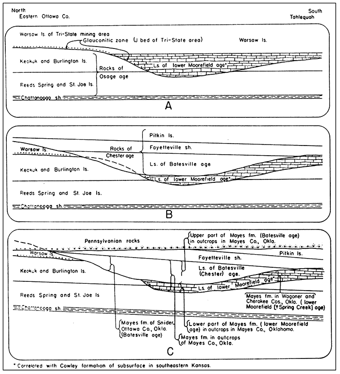
Figure 4--Diagrammatic cross sections showing probable relation of Mayes formation of Oklahoma to limestones of lower Moorefield (†Spring Creek) and Batesville (Chester) age, to Warsaw limestone of Kansas and Missouri. and to Cowley formation of the subsurface in Kansas and Oklahoma. Cross section A shows original relations of Cowley formation and Warsaw limestone to older Mississippian rocks. Cross section B shows erosion of the Cowley and Warsaw and their replacement by Chester rocks, including at the base limestone of Batesville age. Cross section C shows erosion of Mississippian rocks and deposition of Pennsylvanian rocks on eroded surface. Limestone of Batesville (Chester) age overlies the Warsaw and Keokuk toward the north and constitutes the Mayes formation in Ottawa county. Farther south in Mayes county, Oklahoma, the Mayes formation consists partly of limestone of Batesville age and partly of the Cowley formation (lower Moorefield phase of the Mayes). Still farther south in Wagoner and Cherokee counties the Mayes consists of part of the Cowley formation (lower Moorefield alone) without the limestone of Batesville age.
The contrasting lithologic and faunal characteristics and the separation of the areas of outcrop have prevented the recognition in surface studies of the close relation that the writer believes originally existed between the Warsaw of southwestern Missouri and the dark limestones in Mayes county, Oklahoma, containing the lower Moorefield (†Spring Creek) fauna of doubtful stratigraphic position. The dark limestones that crop out in Mayes county, Oklahoma, which the writer believes are marginal deposits of Cowley age, have been linked with the overlying limestone of Batesville age and the two together have been termed the Mayes formation, although it has long been recognized that the two faunas are very different. It is interesting to note that in some places in the outcrops the upper and lower parts of the Mayes are separated by sandy limestone.
Cline (1934, pp. 1156-1158) has shown that the Mayes overlaps upon all the units of the Osage series from the St. Joe to the Keokuk. The Cowley formation in southeastern Kansas has similar relations to the same units of the Osage and in the subsurface is unconformable also on the Kinderhook, Chattanooga, and older rocks.
The relation of outcrops containing the lower Moorefield (†Spring Creek) fauna to the subsurface rocks down dip, as revealed in well cuttings (cross section G-G', pl. 6), provides additional evidence that the lower Moorefield is equivalent to a part of the Cowley formation. At a locality (No. 5 of cross section G-G', pl. 6) described by Snider (1915, p. 29) in sec. 8, T. 19 N., R. 19 E., Oklahoma, that part of the Mayes representing the lower Moorefield consists of black limestone 19 feet thick resting on 169 feet of Reeds Spring and St. Joe limestone measured by the writer. The dark bods of Moorefield age at the outcrop seem to be represented in well cuttings by dark limestones which toward the northwest rest upon progressively lower rocks of Osage age. The dark limestones increase in thickness down dip in this direction from well to well so that in well No. 1 of the cross section G-G', plate 6, they are identical with the Cowley formation of well No. 16 of cross section F-F' (pl. 7) where the Chattanooga and Osage limestones are replaced by the Cowley formation. In the same direction the overlying white limestone of Chester age at the outcrop thins and wedges out beneath the overlying unconformable Pennsylvanian beds.
Prev Page--Chester || Next Page--Fossils
Kansas Geological Survey, Geology
Placed on web Jan. 27, 2013; originally published Sept. 1, 1940.
Comments to webadmin@kgs.ku.edu
The URL for this page is http://www.kgs.ku.edu/Publications/Bulletins/33/08_cross.html