![]()
Prev Page--Contents || Next Page--Mississippian Series
Introduction
Purpose and nature of the Work
This report presents a part of the results of a cooperative investigation of the Mississippian rocks in Kansas conducted jointly by the State Geological Survey of Kansas and the Federal Geological Survey during a period of nearly four years, beginning September 1, 1935, and ending July 1, 1939. The investigation was undertaken in order to determine the relations of the features of the Mississippian rocks to the oil and gas deposits of the state.
The results of a part of this investigation that bear, most directly on the oil and gas deposits have already been published (Lee, 1939). The published report contains a map showing the oil and gas fields and also showing the thickness of the Mississippian limestones in central and eastern Kansas by 50-foot thickness lines. The map reveals the close relation existing between the anticlinal structure of oil and gas pools and areas of thin Mississippian rocks. It also shows several areas that are not productive in which the Mississippian rocks are thin. These are believed to indicate anticlinal areas that have not been adequately explored for oil and gas. Because of the importance of this information to those engaged in the search for oil and gas, the map and a report on this phase of the investigation have been published in advance of the present report.
The material here presented deals chiefly with the stratigraphy and distribution of the Mississippian rocks and it, like that in the earlier report, will also be of interest and value to oil operators and oil geologists.
The Mississippian rocks of Kansas are exposed in the two southeastern townships of Cherokee county, in the southeast corner of the state, but elsewhere in the state they lie below the surface and can be studied only by means of cuttings and cores from wells. For the present investigation, samples were obtained from the warehouses of many oil companies, from individuals, and from the State Geological Survey. To facilitate the study of the samples the well-known representative outcrops of the Mississippian rocks in Missouri and Oklahoma were visited.
Much is known concerning the stratigraphic limits, distribution, relations, and classification of the subdivisions of the Mississippian in the Mississippi valley, but many matters are subjects of debate among geologists. The differences of opinion are due to the considerable similarities that exist in the exposed beds, to the lateral variation in their lithologic and faunal characteristics, and in parts of the section to the lack of significant changes in the faunas of adjacent units.
Many stratigraphic and other problems difficult of solution are also encountered in the subsurface units of the Mississippian and not all of them can be solved by a microscopic study of cuttings and cores. Although lithologic units can be traced by well cuttings from one district to another the cuttings do not provide enough faunal evidence to show the age of a particular unit if the rocks cannot be traced to identifiable outcrops. Although the study of well cuttings has certain obvious disadvantages, their use has some advantage over the study of outcrops. Where well samples are available, the entire section of Mississippian rocks is available for study for hundreds of miles from the outcrop. In the study of surface rocks, the work of the geologist is confined in most regions to a relatively narrow belt of outcropping rocks, the exposures are generally isolated and limited in vertical range, and complete sections representing the full thickness of more than one formation are relatively rare. A long columnar section of rocks is therefore the result of the patching together of a number of limited vertical exposures, generally many miles apart. The character of the Paleozoic rocks of the Mississippi valley is particularly well adapted to the study of the microscopic features of the rocks and of the insoluble residues. The basin during much of Paleozoic time was wide, the seas were in the main shallow and the adjoining land areas were low. Except near shore lines the conditions of sedimentation were unusually uniform, and characteristic lithological features were in the main widespread.
Use of microscopic criteria
Cherty limestones constitute the greater part of the Mississippian rocks; and the similarity in their general appearance makes the lithologic discrimination between the various beds depend on the recognition of microscopic features. The degree to which such distinctions have proved useful seems remarkable. Virtually all areal mapping of beds at the surface, however, depends in the last analysis on some unique characteristic or combination of similar or contrasting lithological characteristics without which no separation of the beds can be made. The use of microscopic characteristics is only a change in technique that adds the microscope to the eye and substitutes a set of well cuttings for a series of outcrops.
The separation of superficially similar limestones in outcrops depends primarily on paleontologic criteria. Locally, lithologic differences are characteristic of certain limestones and are commonly used to identify them. The lithologic characters of the separate units differ, however, in different regions, to the confusion of stratigraphers, and in some regions paleontologists are uncertain of correlations where the faunal content varies but little between adjacent formations or where representative faunules are difficult to procure. The problem of correlation in subsurface work, as in surface work, is therefore to discover groups of beds having common and persistent characteristics and then to determine what changes take place laterally by tracing these units from area to area. H. S. McQueen (1931) of the Missouri Geological Survey, has shown the practical use of microscopic criteria for distinguishing units in well cuttings by the study of insoluble residues that are obtained by treating the cuttings of soluble rocks with hydrochloric acid. This work was first applied successfully by him to the Cambrian and Ordovician rocks of the Ozarks and has now been expanded and applied to the Mississippian beds of Missouri by Mary Hundhausen and J. G. Grohskopf under McQueen's direction.
Application of formation names to subsurface units
The difficulty in correlating surface formations identified by one set of criteria with subsurface units recognized by another set has caused considerable hesitation on the part of the writer in the application of formational names for arbitrarily determined. underground subdivisions. H. A. Buehler, Director of the Missouri Geological Survey, very generously made available that Survey's facilities for the study of insoluble residues. Miss Hundhausen, under the direction of Mr. McQueen, examined and analyzed 15 sets of Mississippian well cuttings taken from wells in critical areas in Kansas. Although the writer had recognized several lithologic units that are traceable from well to well, the Missouri Geological Survey provided the correlations between formations exposed in Missouri and the subsurface lithologic units in Kansas. The use of the terms Chouteau, Sedalia, Reeds Spring, Warsaw, and others in Kansas is based on a comparison by the writer of samples and residues analyzed and examined by the Missouri Geological Survey with samples and residues from other Kansas wells.
The well cuttings from Kansas examined for me by Miss Hundhansen are from a relatively small number of widely distributed wells. In parts of some of the wells where local conditions unlike those in Missouri prevail, the writer has made a different interpretation of the cuttings and residues. In southeastern Kansas the Cowley formation, which is absent in Missouri, has been differentiated; in northeastern Kansas the Gilmore City, parts of which in some wells are not unlike the St. Joe, has been identified tentatively; and the undivided Burlington and Keokuk limestone in Kansas, as reported by Miss Hundhausen, has been separated into two contrasting lithologic units. The wells from which samples were analyzed by the Missouri Geological Survey and made available for this report are listed below.
| Wells in Kansas from which cuttings were analyzed by the Missouri Geological Survey | ||||
|---|---|---|---|---|
| Operator | Farm | No. of well | Location | County |
| Marland | Swenson | No. 1 | Sec. 36, T. 18 S., R. 4 W | McPherson |
| T. C. Johnson | Janssen | No. 1 | Sec. 11, T. 28 S., R. 2 E. | Sedgwick |
| Aylward Prod. Co. | Harrison | No. 1 | Sec. 23, T. 25 S., R. 2 E. | Sedgwick |
| Hollow | Aschmann | No. 1 | Sec. 8, T. 21 S., R. 4 W. | McPherson |
| Sheldon & Wixon | Houston | No. 1 | Sec. 15, T. 28 S., R. 7 E. | Butler |
| National Ref. Co. | Sutter | No. 4 | Sec. 1, T 28 S., R. 6 E. | Butler |
| Empire | Hoffman | No. 1 | Sec. 27, T. 34 S., R. 1 E. | Sumner |
| Empire | Bartel | No. 1 | Sec. 31, T. 20 S., R. 2 E. | Marion |
| Mentor | Muir | No. 1 | Sec. 17, T. 15 S., R. 2 W. | Saline |
| Empire | Beltz | No. 1 | Sec. 36, T. 25 S., R. 4 W. | Reno |
| Watchorn & McNeeley | Spangler | No. 1 | Sec. 23, T. 20 S., R. 32 W. | Scott |
| Prairie | Brown | No. 9 | Sec. 26, T. 34 S., R. 11 E. | Chautauqua |
| St. Louis Sm. & Ref. Co. | Ballard | No. 1 | Sec. 10, T. 35 S., R. 24 E. | Cherokee |
| Kasper | James | No. 1 | Sec. 8, T. 13 S., R 25 E. | Johnson |
| Arnold | Stevenson | No. 1 | Sec. 16, T. 26 S., R. 24 E. | Bourbon |
Those Mississippian formations that are abundantly cherty have in the main such striking characteristics that they can be distinguished by microscopic examination without the aid of insoluble residues. The use of insoluble residues, however, is a great aid in bringing out the distinguishing peculiarities. The noncherty or sparsely cherty formations mentioned below can be satisfactorily determined only with the aid of insoluble residues. The peculiar siliceous assemblages that remain after the removal of limestone and dolomite are the distinguishing characteristics of the St. Louis and Spergen limestones. Residues are necessary also for the determination of the noncherty limestones of the Compton, the Gilmore City, and some phases of the St. Joe. The difference between the silty shales of the Northview and the more argillaceous shales of the St. Joe is also brought out by the use of residues.
Accuracy of samples
Accuracy in the determination of boundaries between stratigraphic units is dependent on the care with which samples have been taken. Cavings and incomplete bailing during drilling operations necessarily contaminate the samples. If grains of chert peculiarly characteristic of higher beds get into a sample the apparent thickness of the higher formation is increased. Boundaries between units are usually indistinct in rotary-drilled wells because of the mingling of cuttings from a considerable thickness of rocks.
The amount of chert present in a sample is by no means a measure of the amount of chert in the rock before drilling. Abrasion by sharp-edged chert fragments may reduce limestone and dolomite to flour in the process of drilling, with the result that much or all of the limestone and dolomite is lost in washing and a disproportionate amount of chert remains. The speed of drilling also is a factor that affects the limestone and chert content, for a wet hole that slows drilling not only reduces the amount of limestone in the sample but also reduces the size of the chert grains in the cuttings. On account of these factors, the meticulous plotting of percentages of lime and chert-in samples from standard-tool holes may not reveal the actual character of the rock any more closely than a rough estimate. Rotary cuttings are useful after the distinguishing characteristics of lithologic units have been determined, but are very unsatisfactory for determining these characteristics. Such cuttings have been used in this investigation only in western Kansas where wells drilled with cable tools are few.
Technique
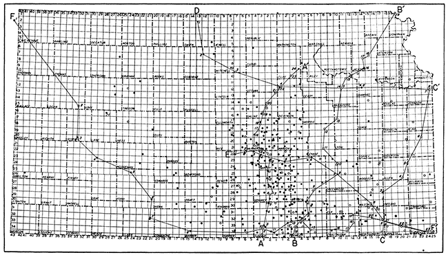
It was discovered in the early part of the work that among the many subtle and varied characteristics of the rocks it was difficult to determine which were the significant peculiarities on first examination. Consequently, wherever the size of the samples was sufficient a small pinch of each of the many samples was mounted on a paper log strip on a scale of 20 feet to the inch as a visible reference for studying the texture, color, fracture, and other features. The samples were mounted with glue on ordinary log strips, and there has been singularly little shedding except for shale grains, which do not become detached from the glue but break across the particles. This scheme is a modification of the practice followed by C. W. Studt of the Union Gas Company of Independence, George M. Fowler of Joplin, Mo., and others. More than 400 such log strips were prepared, and these have made it possible to turn to the original cuttings repeatedly in rechecking and comparing the material under the microscope when it would have been impracticable to go back to the original samples. The locations of wells whose cuttings have been examined and the wells whose insoluble residues were studied are shown in plate 1. The most prominent structural features in Kansas are indicated in figure 1.
Figure 1--Sketch showing principal structural features of Kansas. Chautauqua arch, indicated by pre-Chattanooga outcrops of base of Simpson sandstone (after Hugh W. McClellan); trends of Nemaha ridge fold and Voshell anticline as shown on thickness map of Mississippian limestones (Wallace Lee, Bulletin 26, Kansas Geological Survey); Salina basin, deepest part as indicated by Mississippian thickness map; central Kansas uplift as shown by area in which Mississippian limestone is absent; Forest City and Cherokee basins from thickness map of Cherokee shale by N. W. Bass (Bulletin 23, Kansas Geological Survey); North Kansas basin of John L. Rich from thickness map of Chattanooga shale of this report; and Dodge City basin (after Hugh W. MeClellan).
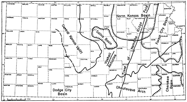
Plate 1--Map showing (by dots) location of wells from which samples of Mississippian rocks were studied and position of cross sections. The circles from which insoluble residues were also examined. The lines connecting wells indicate the position of cross sections of plates 5, 6, and 7. [A larger Acrobat PDF version of this figure is available.]
The samples were examined with a binocular microscope using a 55 mm. objective and a 6x eyepiece. The magnification thus obtained was 22 diameters. This is somewhat greater than that in general use by oil company geologists in the examination of cuttings, but, although it reduces the field, it reveals some of the subtle distinctions of chert and limestone that are easily overlooked with a lower magnification.
Terminology
Terminology presents some problems in describing textures of limestone, dolomite, and chert because there is no standardized meaning for certain much-used words. The following words are used herein with the specialized meanings indicated.
Semigranular: Consisting of coarse crystalline grains, principally fossil fragments, in a microcrystalline matrix. In some zones the semigranular limestones are crinoidal.
Grainy: Consisting of microscopic crystals of limestone or dolomite or particles of silt sparsely distributed in a dull opaque usually calcareous matrix. The matrix, in some rocks, is cryptocrystalline; in others earthy. By decrease of the calcareous matrix this texture may become sucrose or silty.
Sucrose: Consisting of microscopic coarse or fine crystals--in most cases dolomite--packed closely (without matrix) like grains of granulated sugar.
Stippled: Having a character caused by the complete replacement by silica of rocks having grainy texture, resulting in a stippled pattern on the broken surface of the chert. The sharp outline of the replaced impurities is blurred in some zones, giving a cloudy margin to the spots.
Mottled: Composed of parti-colored chert in patches without sharp margins; microscopic but much coarser than is indicated by stippled.
Matted: Composed of closely packed fragments of silicified microfossils cemented together in a siliceous matrix.
Streaked: Having the microfossiliferous fragments of matted chert imperfectly replaced or subsequently modified; resulting in a blurring of the outlines of the inclusions.
Even-textured: Having a homogeneous character and, as applied to chert, a texture comparable to the term lithographic in referring to the texture of limestone.
Cotton rock: A soft, porous siliceous rock composed of white, opaque, incompletely cemented microscopic particles of silica.
Acknowledgments
The author is particularly indebted to the Missouri Geological Survey, the Shell Petroleum Corporation, the Union Gas Company of Independence, and the Skelly Oil Company for the use of cuttings, and acknowledges with thanks the use of material from the geological departments of Atlantic Refining Company, Gulf Oil Corporation, Carter Oil Company, Magnolia Petroleum Company, Sinclair-Prairie Oil Company, Amerada Petroleum Company, Indian Territory Illuminating Oil Company, National Refining Company, Ohio Oil Company, Phillips Petroleum Company, Stanolind Oil Company, Continental Oil Company, Darby Oil Company, and Pure Oil Company. R. A. Wharton, Edward A. Koester, Howard S. Bryant, James I. Daniels, Anthony Folger, Geo. H. Norton, and many other individuals have been helpful.
Prev Page--Contents || Next Page--Mississippian Series
Kansas Geological Survey, Geology
Placed on web Jan. 27, 2013; originally published Sept. 1, 1940.
Comments to webadmin@kgs.ku.edu
The URL for this page is http://www.kgs.ku.edu/Publications/Bulletins/33/02_intro.html