![]()
Surficial geology and stratigraphy of Russell County, Kansas
By Alan F. Arbogast1 and William C. Johnson2
1Michigan State University; 2University of Kansas
Originally published in 1996 as Kansas Geological Survey Technical Series 7. This is, in general, the original text as published. The information has not been updated. The publication supports the Russell County geologic map and is also available as an Acrobat PDF file.
Abstract
Russell County is located in north-central Kansas, within the Smoky Hills physiographic province, which exhibits a wide variety of erosional and depositional landscapes. Outcrops range in age from Upper Cretaceous to Holocene, including the Dakota Formation, Graneros Shale, Greenhorn Limestone, Carlile Shale, Niobrara Chalk, Ogallala Formation, and several unconsolidated Quaternary eolian and fluvial deposits. The Dakota Formation, consisting of deltaic sandstones and mudstones, underlies the entire county but crops out primarily in the eastern one-half of the study area. The Graneros Shale is a thin formation of dominantly fissile shale, poorly exposed, that crops out conformably between the Dakota and the overlying Greenhorn Limestone. The Greenhorn Limestone consists of transgressive beds of shale and chalk and crops out countywide. Intensively dissected in some areas, the Greenhorn Limestone forms steep canyons where resistant beds of chalk and chalky limestone, such as the Fencepost Limestone, are present. The Carlile Shale consists of two distinct members in Russell County, the Fairport Chalk Member and the Blue Hill Shale Member. Exposures of the Fairport Chalk Member are common throughout the county but are thickest in the northwestern corner, whereas the Blue Hill Shale Member is exposed only in the northwestern corner of Russell County. Due to the paucity of exposures, the Codell Sandstone Member of the Carlile Shale is not differentiated from the Blue Hill Shale Member. Unconformably overlying the Carlile is the Niobrara Chalk, which consists of two distinct members, the Fort Hays Limestone Member and the Smoky Hill Chalk Member. Both members of the Niobrara Chalk are confined to the extreme northwestern corner of Russell County. Outcrops of the Miocene-age Ogallala Formation, a sedimentary sequence of Rocky Mountain-derived fluvial sediments, have been tentatively identified and are largely confined to the northwestern corner of the county.
Quaternary deposits, ranging in age from pre-Illinoian to Holocene, mantle much of Russell County, but are generally poorly exposed. Pre-Illinoian associations are tentative, consisting of the Grand Island and Sappa Formations, and are based on the topographic position of upland gravel deposits. Illinoian stratigraphy consists of the Crete Formation, Loveland Loess, and Sangamon Soil. Sands and gravels of the Crete Formation are expressed as a high terrace along the major streams in the county, but their distribution is uncertain. The Loveland Loess is widely distributed in north-central Kansas and has been recognized at one site in Russell County. The Sangamon Soil, a major pedostratigraphic feature which caps the Illinoian Loveland Loess, has been identified in Russell County. Overlying the Sangamon Soil is the middle-Wisconsinan Gilman Canyon Formation and the late-Wisconsinan Peoria Loess. The Gilman Canyon Formation is a loess that accumulated at a sufficiently slow rate for the development of a soil. Accelerated loess fall during the late Pleistocene produced the Peoria Loess, which mantles the upland.
Holocene stratigraphic elements include the Brady Soil, Bignell Loess, modern surface soil, and fluvial deposits. The Brady Soil caps the Peoria Loess and is discontinuous in Russell County but is recognizable only where it is buried by Bignell Loess. Holocene fluvial deposits occur as fill in a high terrace and as post-1,000-yr B.P. floodplain sediments.
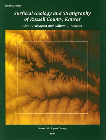
Cover: Shaded digital elevation model for Russell County, Kansas. Higher elevations are depicted in shades of yellow, while lower elevations appear in shades of green. The Smoky Hill drainage can be seen flowing from west to east across the lower part of Russell County, and the Saline River drainage, also flowing from west to east, can be seen in the north. The cover illustration was created by merging four 1:250,000 scale digital elevation models, projecting them to a Lambert Conformal Conic projection, cutting out the area of interest, and embedding the Russell County boundary. Illustration production courtesy of the Kansas Applied Remote Sensing Program, The University of Kansas, Lawrence, Kansas 66045.
Kansas Geological Survey, Geology
Placed on web April 8, 2013; originally published 1996.
Comments to webadmin@kgs.ku.edu
The URL for this page is http://www.kgs.ku.edu/Publications/Bulletins/TS7/index.html