![]()
Prev Page--Contents || Next Page--Stratigraphy
Introduction
Purpose and scope of the investigation
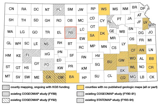
In recent years, the Kansas Geological Survey has initiated a series of county-level mapping projects in Kansas. The primary goal of the program was to produce accurate, high-resolution maps of surficial geology in selected counties (fig. 1). This report augments the geologic map of Russell County (Johnson and Arbogast, 1996), which was produced by the automated cartography facility of the Kansas Geological Survey. Although many advantages exist for storing the map digitally, the primary one is that the map can be easily revised without the complications associated with traditional cartography. All original project field materials (e.g., maps and aerial photography) are available in the Kansas Geological Survey archives.
Figure 1--Index map of Kansas showing the location of Russell County and the status of county-scale geologic mapping; those counties without shading or patterns (e.g., Cheyenne) have older geologic maps.
Geologic mapping of Russell County was begun in the spring of 1991 and was completed in the early summer of 1992. During the spring of 1991, initial reconnaissance was conducted via remote sensing of aerial photography and field survey. Summer months were dedicated to detailed mapping of alluvium and Cretaceous bedrock, followed by mapping of Pleistocene loess in the fall. Subsequent work focused on areas with ill-defined contacts or of relative geologic complexity.
Location and nature of the study area
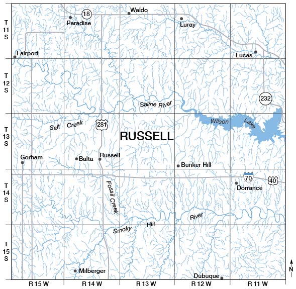
Russell County is located in north-central Kansas, bounded on the east by Lincoln and Ellsworth counties, on the south by Barton County, on the west by Ellis County, and on the north by Osborne County (fig. 1). It lies within the Smoky Hills physiographic province and is characterized by a fascinating diversity of landscapes, owing largely to dissection of Cretaceous chalks, shales, and sandstones by the Smoky Hill River, Saline River, and their tributaries (fig. 2). Where extensive dissection has occurred, steep-sided valley walls are supported by resistant units (e.g., Fencepost Limestone) that are separated by less-resistant strata (e.g., Graneros Shale). Dissection of the Dakota Formation in the eastern third of the county has left a landscape of hoodoos where resistant, lenticular sandstone bodies (e.g., Rocktown channel sandstone) protect underlying mudstones. A mantle of late Quaternary loess of varying thickness caps most uplands in the county. In the larger valleys of Russell County, several cycles of alluvial cutting and filling during the Quaternary Period (Pleistocene and Holocene epochs) have resulted in deposition of gravel deposits and fine-grained alluvium which underlie terraces.
Figure 2--Drainage pattern for Russell County.
Previous geologic investigations
The first published research in Russell County was conducted by Hay (1889), who examined a lignite horizon in the Dakota Formation. Intensive research began in the 1920s, as exemplified by Rubey and Bass's (1925) description and map of Russell County geology. A subsurface correlation of rock units from Russell County to Marion County was completed by Bramlette (1925). In 1926, Bass included Russell County in a study of the petroleum and gas resources of western Kansas. That same year, Hedberg (1926) analyzed the effect of gravitational compaction on the structure of sedimentary rocks in and around Russell County.
Since the late 1920s, research in Russell County has largely focused on petroleum resources and the prominent Cretaceous shales and chalks of the area. In the context of petroleum production, Hintze (1928) discussed the discovery of the Gorham oil district, and Allan and Valerius (1929) studied the structure of the Fairport oil field. Chemical analyses of some oil-well waters in Russell, Ellis, and Trego counties was conducted by Runyon and Rankin (1940). In 1960, Landes et al. analyzed the petroleum resources in basement rocks in and around Russell County. Riggs et al. (1963) conducted a petroleum engineering study of Hall-Gurney oil field in Russell County. Recently, a series of maps (e.g., Ross and Wong 1989a, 1989b, 1990a, 1990b ) were constructed showing the oil and gas fields in and around Russell County.
The Cretaceous shales and chalks of north-central Kansas, including Russell County, have received considerable attention in the past 60 years. Studies of the general stratigraphy of the Colorado and Montana groups throughout north-central Kansas include those by Cobban (1949) and Hattin and Cobban (1977). A number of studies have focused on individual Upper Cretaceous formations. For example, characteristics of the Dakota Formation have been described by Franks (1967), Hattin (1967), and Siemers (1971 a, 1971 b). The Graneros Shale has been the focus of appreciable study. Hatfield (1961), for example, studied the paleoecology of the Graneros Shale in and around Russell County, and Hattin (1965a) described the stratigraphy of that unit. The nature of limestone beds in the Greenhorn Limestone was analyzed by Hattin (1971), who subsequently (1975) described the stratigraphy and depositional environment of the Greenhorn. The primary study of the Carlile Shale was conducted by Hattin (1962), who analyzed the stratigraphy of the Carlile in and around Russell County. The petrography, geochemistry, and economic utilization of the Fort Hays Chalk in Russell County and north-central Kansas was studied by Dubins (1947). Regarding the inclusion of all Cretaceous rocks in Russell County within the Colorado Group, Hattin (personal communication) suggests that the term Colorado Group be discontinued because the units are too lithologically diverse to be included within one group. As a result, the term Colorado Group is not used in this report.
Because the geology of north-central Kansas ellicits such interest, several guidebooks have been published that include sites in Russell County. The first field guide, which focused on Pleistocene deposits, was produced by Frye et al. (1951). Guidebooks illustrating the nature of Cretaceous stratigraphy in and around Russell County include those by Hattin (1965b), Hattin and Cobban (1965), Nickel (1972), and Hattin and Siemers (1978).
In the last 15 to 20 years, interest in Russell County and the surrounding area has focused on salt dissolution and sinkhole evolution. For example, Burgat and Taylor (1972) described highway subsidence associated with salt dissolution. In 1977, Hansen studied dissolution in the Hutchinson Salt Member of the Wellington Formation near Russell. Knapp and Steeples (1981) and Knapp et al. (1989) conducted seismic investigations of collapse structures associated with salt dissolution.
Other research not cited here, such as that relating to ground water, has been conducted and reported for Russell County. A listing is available in the Bibliography of Kansas Geology, 1823-1984 (Sorensen et al., 1989, p. 388-389), and the Bibliography of Kansas Geology, 1985-1989 (Sorensen, 1994, p. 147).
Methods of investigation
The geology of Russell County was mapped from stereopairs of black and white aerial photography (1:24,000) taken in January 1986 for statewide property reappraisal, 7 1/2-minute topographic quadrangle maps, and field survey. Minimum thickness of any mappable unit was 1.8 m (6 ft), a criterion applicable primarily to loess and alluvium. Although no deep drilling or coring was done in association with the mapping, unit thicknesses beneath the solum were verified with hand and machine augering.
To assess the correlation between soil units and lithology, the Soil Survey of Russell County (Jantz et al., 1982) was consulted. After an initial field survey, it was determined that the relationship of soil units and bedrock geology was too poor and unpredictable to use the soil maps exclusively for mapping (table 1). The correlation between soil units and unconsolidated deposits, specifically gravel and loess, was sufficient, however, for preliminary mapping in the laboratory. Loess boundaries, for example, could be generally defined by those of the Harney and Holdredge soil map units, with subsequent field refinement.
Table 1--Degree of correspondence between geologic map units and soil series associations.
| Geologic unit | Soil series | Correspondence of oil distribution to geologya |
|---|---|---|
| Loess | Crete | good |
| Harney | good | |
| Ogallala Formation | Dorrance | good |
| Niobrara Chalk | Nibsonb | fair |
| Carlile Shale | Boguec | good |
| Corinthd | fair | |
| Greenhorn Limestone | Armo | fair |
| Edalgo | fair | |
| Nibsone | fair | |
| Wakeenf | fair | |
| Graneros Shale | Nibsone | poor |
| Lancasterg | poor | |
| Dakota Formation | Hedville | good |
| Lancasterg | fair | |
| High terrace (gravel) | Dorrance | good |
| Wells | fair | |
| Low terrace and floodplain | Detroit | fair |
| Humbarger | fair | |
| Inavale | fair | |
| McCook | fair | |
| Munjor | fair | |
| Roxbury | fair | |
|
||
Initial mapping focused on alluvial deposits because aerial photography permitted easy recognition and delineation of floodplains and terraces. Rocks of the Cretaceous System, the most time-consuming to map, were mapped next. The Fencepost Limestone, a widespread, resistant bed of chalky limestone capping the Greenhorn Limestone, was an important stratigraphic marker during the early stages of surficial bedrock mapping because it is easily detected on the aerial photography. We next determined the distribution of the Graneros Shale, which delineated the lower and upper contacts of the Greenhorn Limestone and Dakota Formation, respectively. Although boundaries of the Graneros were often hard to find due to its thinness and sparse exposure, its mapping was facilitated by the location of numerous farm ponds situated on the impermeable shale. Loess deposits were delineated in the final phase of mapping.
As mapping progressed, geologic contacts were first drawn on paper copies of the 7 1/2-minute, 1:24,OOO-scale topographic quadrangles and were then transferred to planimetric Mylar base maps of the same scale. Subsequent digitizing and map production through computer-aided cartography using the GIMMAP software was conducted at the Kansas Geological Survey.
Prev Page--Contents || Next Page--Stratigraphy
Kansas Geological Survey, Geology
Placed on web April 8, 2013; originally published 1996.
Comments to webadmin@kgs.ku.edu
The URL for this page is http://www.kgs.ku.edu/Publications/Bulletins/TS7/02_intro.html