![]()
Prev Page--Introduction || Next Page--Recent Geologic History
Stratigraphy of outcrops
Rock units cropping out in Russell County range in age from Lower Cretaceous to Holocene and include the Dakota Formation, Graneros Shale, Greenhorn Limestone, Carlile Shale, Niobrara Chalk, Ogallala Formation, and a variety of unconsolidated Quaternary deposits (loess and alluvium). Rock- and time-stratigraphic units germane to this study are represented in fig. 3.
Figure 3--Classification of rocks in Russell County (after Baars, 1994).
Cretaceous System--Lower Cretaceous Series
Dakota Formation
Meek and Hayden (1862) first used the name Dakota Group to describe exposures of sandstone, clays of various colors, and lignite beds near Dakota City, Dakota County, Nebraska. Plummer and Romary (1942) subsequently used the term Dakota Formation to include all deposits of dominantly continental and littoral origin lying between the transgressive deposits of the Kiowa Shale and the Graneros Shale.
The Dakota Formation crops out through much of western Kansas, where the formation has a thickness ranging from 200 ft to 300 ft (60 m to 90 m). In Russell County, the upper 100-150 ft (30-46 m) of the Dakota Formation is exposed (Hattin and Siemers, 1978). Six major facies have been delineated in this part of the Dakota (Hattin, 1965b; Siemers, 1971 a, 1976; Hattin and Siemers, 1978) and represent a transition to shallow-marine deposits in an environmentally diverse, deltaic, and marginal marine setting at the onset of the Greenhorn transgression. In general, these facies consist of yellowish to reddish and greenish and brownish mottled mudstones, lignites, and ironstones interbedded and overlain by crossbedded, elongate-trough-shaped sandstones (e.g., Rocktown channel sandstone) and flat-bedded, elongate-tabular-shaped sandstones. A variety of trace fossils such as Planolites and Skolithos are common in the Dakota Formation as well as such diverse, marginal marine macroinvertebrates as Geltena subcompressa and Exogyra spooneri (Hattin, 1967; Siemers, 1971b).
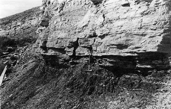
Although the Dakota Formation underlies all of Russell County, it is extensively exposed only in the eastern one-half of the county. A variety of excellent exposures of the Dakota exist, including two (figs. 4 and 5) generally described by Hattin and Siemers (1978). On the geologic map of the county (Johnson and Arbogast, 1996), all major facies of the Dakota are included within the map unit Kd.
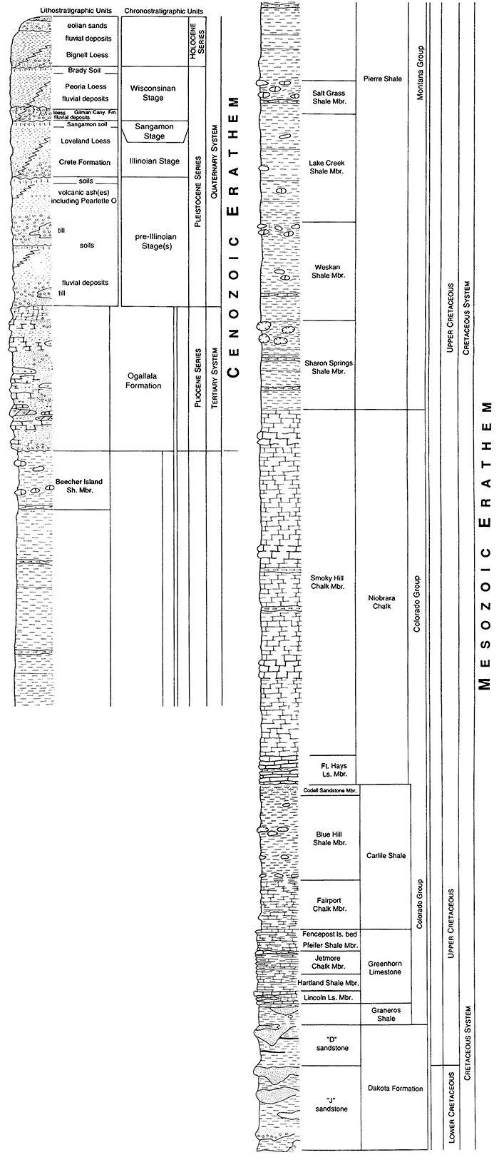
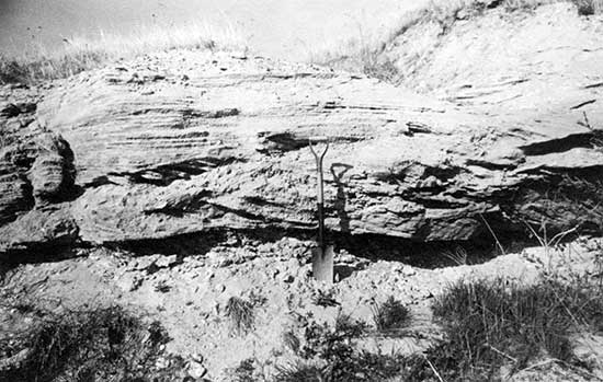
Figure 4--Exposure of the upper part of the Dakota Formation located in a roadcut approximately 0.5 mile (0.6 km) from the Russell County line in the NW SE sec. 19, T. 13 S., R. 10 W, Lincoln County. Active fill of the Rocktown channel sandstone is represented in units 1a and 1b, with large trough features in unit 1a--1-3 ft (0.3-0.9 m) high and 5-15 ft (1.5-4.6 m) across-and relatively small cross bed sets in unit 1b, 0.5-1.5 ft (0.15-0.46 m). The unit 1 sandstone bed is truncated by carboniferous, silty claystone and shale of unit 2, a 25-ft (7.6-m)-thick deposit of abandoned-channel fill. Unit 3, which is 16 ft (4.9 m) thick. is a root-mottled, carbonaceous sandy siltstone of unknown origin. Unit 4 consists of flat-bedded sandstone that is 31 ft (9.5 m) thick. Reproduced from Hattin and Siemers (1978).
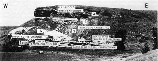
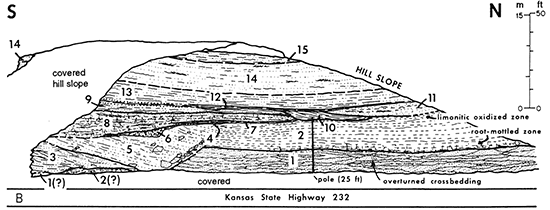
Figure 5--Exposure of the upper part of the Dakota Formation, illustrating the complex relationships of lithologic units, located in a roadcut approximately 0.5 mi (0.6 km) from the Russell County line in the NW SE sec. 19, T. 13 S., R. 10 W., Lincoln County. In general, unit 1 represents active-channel fill, while units 2-6 include complex floodplain and partially abandoned channel-fill deposits. Units 7-12 are likely deltaic deposits from a mixed fluvial and marginal-marine environment during the onset of the Graneros transgression. The discordant surface labeled 4 may represent faulting of unit 5 against units 1 and 2 before aggradation of unit 6. Reproduced from Hattin and Siemers (1978).
Cretaceous System--Upper Cretaceous Series
Graneros Shale
The Graneros Shale was named by Gilbert (1896) for exposures along Graneros Creek near Walsenburg, Colorado. The earliest definitive description of the Graneros Shale in Kansas, then called "the Bituminous Shale Horizon," was by Logan (1897) when he recorded general attributes such as thickness, color, and structure. The next year, Logan (1898) correlated this unit with the Graneros Shale of Colorado. Rubey and Bass (1925) extensively described the Graneros Shale in Russell County, but the most detailed study of the Graneros in Kansas was conducted by Hattin (1965a) who analyzed the stratigraphy of the unit throughout the Smoky Hills. The Graneros Shale is composed predominantly of fissile, noncalcerous, medium- to dark-gray shale that weathers to shades of gray and yellowish brown; it is approximately 30 ft (10 m) thick in Russell County (Rubey and Bass, 1925). Clay-ironstone and calcareous septarian concretions occur locally. At many localities, interbeds of calcareous and noncalcerous siltstone and sandstone lie in the middle part of the shale. In addition, several layers of bentonite and beds of skeletal limestone are found in the middle and upper parts of the Graneros. A variety of invertebrate fossil material, including Inoceramus rutherfordi and Ostrea beloiti, are common in the upper part of the formation.
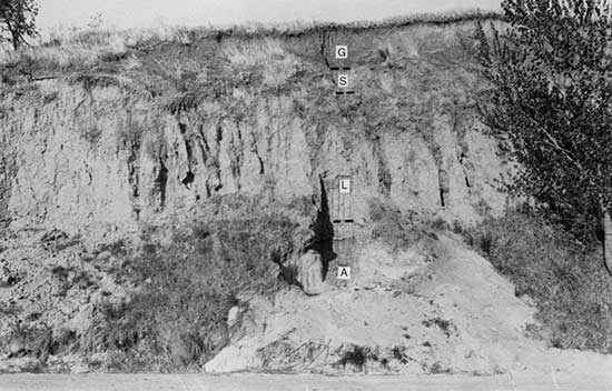
The Graneros Shale crops out as a narrow formation between the overlying Greenhorn Limestone and underlying Dakota Formation in Russell County (Johnson and Arbogast, 1996). According to Rubey and Bass (1925), irregular variations in the thickness of the shale in Russell County may exceed 20 ft (4.5 m) due to intertonguing with the Dakota. The outcrop belt may be as much as 1 mile (1.6 km) wide on the northern side of stream valleys due to the regional northwest dip of the bedrock, but it is usually less than a quarter of a mile (0.4 km) throughout the county. Topographically, the Graneros usually forms lowangle slopes, except in steep-sided valleys where the shale is protected by resistant rocks at both contacts. Complete exposures of the Graneros Shale are limited in Russell County because dense sod or talus usually covers part of the unit. Hattin (1965a) described an exposure, however, in the NW sec. 35, T. 12 S., R. 14 w., along U.S. Highway 281, north of Russell (fig. 6). Another exposure of the Graneros, in the NE sec. 33, T. 12 S., R. 14 W., was created by recent slumping; in this exposure the contact with the overlying Greenhorn Limestone is nicely expressed (fig. 7). On the geologic map of the county (Johnson and Arbogast, 1996), the Graneros Shale is designated Kgr.
Figure 6--Exposure of the Graneros Shale, located in the NW sec. 35, T. 12 S., R. 14 W., on U.S. Highway 281 north of Russell. Described by Hattin (1965a), the Graneros at this locality lies conformably on the Dakota Formation. A. Arbogast is kneeling on the contact.
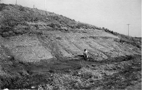
Figure 7--The Graneros Shale-Greenhorn Limestone contact (rock hammer) in an exposure created by recent slumping (NE sec. 33, T. 12 S., R. 14 W).
Greenhorn Limestone
In central Kansas, the Greenhorn Limestone outcrop extends northeastward from Ford County, through Russell County, into the northwestern corner of Washington County on the Nebraska border. The Greenhorn is unconformable on the Graneros Shale at most localities (Hartin, 1975). The first references and descriptions of rocks, later included within the Greenhorn Limestone, were made by Hayden (1872), Mudge (1876), and St. John (1883). In 1899, Logan described in detail the rocks of the Limestone Group, later to become the Greenhorn. The term "Greenhorn" was first used for Kansas rocks by Darton (1904) to describe the flaggy and chalky limestones of central Kansas. The earliest comprehensive studies of the Greenhorn were conducted by Rubey and Bass (1925) in Russell County and by Bass (1926) in western Kansas. In these reports, the fundamentals regarding thickness, lithology, important fossils (e.g., Inoceramus prefragilis, Ostrea beloiti), and stratigraphic correlations were established, as well as the subdivision of the Greenhorn into the Pfeifer, Jetmore, Hartland, and Lincoln members. The most intensive and extensive study of the stratigraphy and depositional environment of the Greenhorn, including the most detailed analysis of each member, was conducted by Hattin ( 1975).
The Greenhorn Limestone is approximately 100 ft (30 m) thick in Russell County. The Lincoln Limestone Member at the base of the Greenhorn is about 20 ft (6 m) thick (Rubey and Bass, 1925). Interbedded chalky shales and chalky limestones, both of which are light gray and weather to yellowish gray or yellowish tan, compose the bulk of the Lincoln. Also contained within the shales of the Lincoln are thin beds of bentonite and isolated lenses of skeletal limestone. Conformably above the Lincoln is the Hartland Member, which is about 35 ft (11 m) thick. Although this unit is typically referred to as the Hartland Shale. Hattin (personal communication) favors discontinuing the use of the term "Shale" because it is not a true shale. The contact between the Lincoln Limestone and the Hartland is at the top of a concentration of thin beds or lenses of skeletal limestone (Hattin, 1975). The Hartland is largely a gray, chalky shale that contains numerous bentonite seams and a few thin beds of chalky limestone. Conformably overlying the Hartland is the Jetmore Chalk Member, whose contact with the Hartland is placed at the base of the lowest of numerous, closely spaced, conspicuous hard beds of chalky limestone (Hartin, 1975). The Jetmore Member, which is approximately 20 ft (6 m) thick in Russell County, consists of chalky shale and 12 to 15 beds of chalky limestone; the uppermost bed of the member is the Inoceramus or Shellrock limestone. At the top of the Greenhorn is the Pfeifer Member, which has an average thickness of 20 ft (6 m) in Russell County (Rubey and Bass, 1925) and conformably overlies the Jetmore Member. Typically this unit is referred to as the Pfeifer Shale, but Hattin (personal communication) suggests that the term "Shale" be dropped because the Pfeifer is not a true shale. In general, the Pfeifer consists of interbedded chalky shale and chalky limestone that accumulated during a maximum transgression. Three marker beds are contained within the Pfeifer. The lowermost is an unnamed bed of chalky limestone that directly overlies a thin seam of bentonite. An intermediate marker bed is a bentonite and granular-calcite unit known as the "sugar sand." At the top of the Pfeifer is the well-known Fencepost Limestone, which is bluish gray and weathers to light tan.
The Greenhorn Limestone is widespread in Russell County with the outcrop belt ranging from less than one-fourth mile (0.35 km) along bluffs to several miles (>1.5 km) in less dissected, interstream areas (Rubey and Bass, 1925). Intensive dissection of the Greenhorn, especially in the central part of the county, by tributaries in the southern uplands of major stream basins has resulted in steep canyon walls where members of the Greenhorn are clearly visible. An exposure described by Hattin (1975) on the east side of the Bunker Hill-Luray Road halfway along the western edge of sec. 18, T. 13 S., R. 12 W. (fig. 8) illustrates the nature of the unit. An exceptional exposure of the Greenhorn, one that shows all four members (fig. 9), is located in a tight meander bend of the Saline River in the NE sec. 33, T. 12 S., R. 14 W. Abandoned and active Fencepost quarries, such as the one illustrated in fig. 10, are scattered on upland margins throughout the county. Because the rocks of each member of the Greenhorn are genetically similar (i.e., marine sediments that accumulated during a transgressive phase), the formation has not been subdivided on the geologic map of the county (Johnson and Arbogast. 1996); they are included within the map unit Kgh.
Figure 8--The Hartland Shale and Jetmore Chalk Members of the Greenhorn Limestone exposed in a roadcut, described by Hattin (1965b), on the east side of the Bunker Hill-Luray Road, halfway along the western edge of sec. 18. T. 13 S., R. 12 W. The arrow points to the approximate location of the Hartland-Jetmore contact.
Figure 9--Extensive exposure of the Greenhorn Limestone along a meander bend of the Saline River in the NE sec. 33, T. 12 S., R. 14 W. In Russell County, the Greenhorn Limestone unconformably overlies the Graneros Shale, which is the dark unit adjacent to A. Arbogast. At this locality, all four members of the Greenhorn (Lincoln, Hartland, Jetmore, Pfeifer) are exposed.
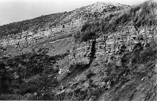
Figure 10--A small fence-post quarry (abandoned) in the SE sec. 29, T. 11 S., R. 15 W. The Fencepost Limestone (arrow) is the uppermost bed of the Greenhorn Limestone. Early settlers of Russell County discovered that, once exposed, the Fencepost Limestone was very soft and could be easily worked. Upon subsequent weathering, the chalk hardened. Conformably overlying the Fencepost Limestone at this locality is the lower pan of the Fairport Chalk Member of the Carlile Shale.
Carlile Shale
The Carlile Shale was named by Gilbert (1896) from exposures along the Arkansas River at Carlile Station southwest of Pueblo, Colorado. Subsequent modification and subdivision of the Carlile Shale in Kansas was done by Logan (1899) and Bass (1926). Hattin (1962) conducted the most intensive study of the Carlile Shale, including a detailed analysis of each member. In Kansas, the Carlile crops out generally in two areas (Hartin, 1962): an extensive outcrop ex.tending from Finney County northeastward to Washington County and a smaller area in northwestern Hamilton County. The Carlile Shale is approximately 300-ft (90 m) thick in Russell County, with the thickest outcrops in the northwestern corner of the county. It consists of three members. At the base of the Carlile is the Fairport Chalk Member, which is approximately 85 ft (55 m) thick. The middle member is the Blue Hill Shale Member, an approximately 195-ft (125-m)-thick unit of dark-gray, clayey, fissile shale. At the top of the Carlile is the Codell Sandstone Member, which has a maximum thickness of no more than 25 ft (7.6 m) and thins to less than 1 ft (0.3 m) (Rubey and Bass, 1925). On the geologic map of the county (Johnson and Arbogast, 1996), the Fairport and Blue Hill members were differentiated and mapped as Kc and Kb, respectively. Because only one exposure of the Codell Sandstone was found, the Codell is undifferentiated from the Blue Hill Shale Member and is included within the map unit Kb.
Fairport Chalk Member--Formerly the Fairport Chalky Shale, the Fairport Chalk Member is a complex of marine chalks and marls that lie conformably on the Greenhorn Limestone. Outcrops of the Carlile Shale are widespread in Russell County, with isolated remnants of the lower part on hilltops in the eastern third of the county and extensive outcrops in the western two-thirds of the project area. In the northwestern corner of Russell County, the entire thickness of the Fairport is exposed (Rubey and Bass, 1925).
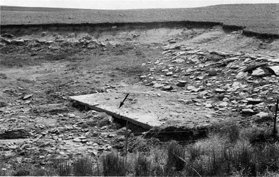
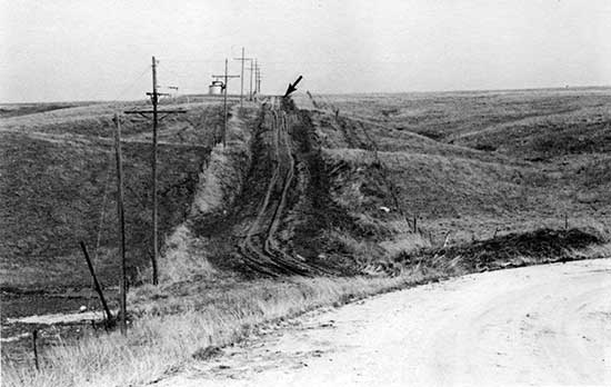
Along Interstate 70, near the western county line, three sinkholes (Witt, Crawford, and Roubach) have recently formed in the surface of the Carlile Shale (fig. 11). Seismic investigations of the sinkholes indicates they have developed during the last 25 years due to significant dissolution of the Hutchinson Salt member of the Permian Wellington Formation 400-500 m (1,300-1,600 ft) below the surface (fig. 12). Apparently, dissolution of the Hutchinson Salt Member is associated with saltwater disposal wells (fig. 11) within the Gorham oil field (Knapp and Steeples, 1981; Steeples et al., 1986; Knapp et al., 1989).
Figure 11--Map showing the location of sinkholes relative to Interstate 70 in secs. 2 and 3, T. 14 S., R. 15 W. in western Russell County (from Knapp et al., 1989). The tick marks along the axes formed by 1-70 and the north-south section boundary represent 10-m intervals, which are numbered every 20 m.
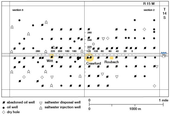
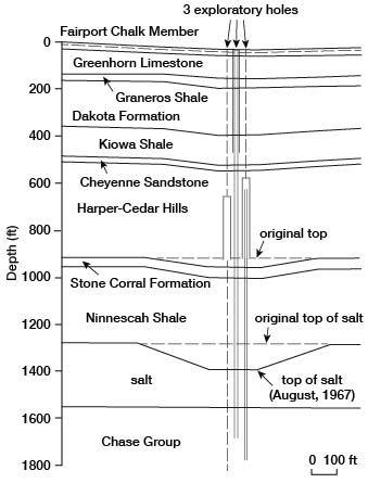
Figure 12--Geologic profile of the Crawford sink in the SW sec. 2, T. 14 S., R. 15 W (from Knapp et al., 1989).
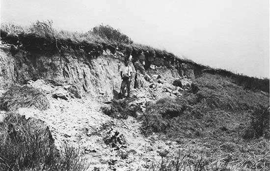
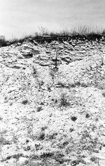
As it occurs in Russell County, the Fairport Member consists of bluish-gray to gray chalky shale, chalky limestone, and calcareous shale that weather yellowish gray and grayish orange; it is considerably more resistant than the overlying Blue Hill Shale Member. At the base of the Fairport Member, chalky limestone is more abundant and is identical to the upper beds of the Greenhorn Limestone, reflecting deposition during a maximum transgression (Hartin, 1962). Thin bentonite beds occur throughout the member. Important fossils include Inoceramus and Pseudoperna, fish scales and sharks' teeth. A section of the lower Fairport Member, measured by Hattin (1962) in the NE sec. 5, T. 13 S., R. 15 W, is shown in fig. 13.
Figure 13--Roadcut in the lower part of the Fairport Chalk Member of the Carlile Shale, located in the NE sec. 5, T. 13 S., R. 15 W., described by Hallin (1962). The spade (arrow) rests on the Fencepost Limestone of the uppermost Greenhorn Limestone. The Fairport Chalk Member is similar to the Greenhorn Limestone in that alternating beds of chalk are separated by beds of marl and chalky shale.
Blue Hill Shale Member--Although a type section has never been designated, the name Blue Hill Shale was apparently derived from the Blue Hills of western Mitchell County, Kansas, by Logan (1897). In Russell County, the Blue Hill Shale Member consists of a dark-gray clayey, blocky to fissile shale, that contains septarian concretions of calcium carbonate and clay-ironstone. The Blue Hill Member lies between the underlying chalky shale of the Fairport Member and the overlying Codell Member of the Carlile Shale. The Blue Hill Shale Member consists primarily of quartz-dominant terrigenous detritus eroded from surrounding Paleozoic and Precambrian terranes during a regressive phase (Hattin, 1962). Strikingly uniform throughout, the primary differences within the Blue Hill are the number, size, and composition of the calcium concretions and an increase in sand content toward the top of the member (Rubey and Bass, 1925). The Blue Hill Member crops out on the higher ridges in the northwestern corner of Russell County and is usually expressed topographically as broad, gentle slopes, but may be exposed locally on steep bluffs where the overlying, more resistant Fort Hays Limestone serves as a protective caprock (fig. 14). Recent slumping in the SE sec. 5, T. 11 S., R. 15 w., has exposed portions of the Blue Hill Member (fig. 15), but it may also be observed on the surface of unimproved roads (fig. 16).
Figure 14--Typical landscape developed on the Blue Hill Shale Member of the Carlile Shale located in the SE sec. 5, T. 11 S., R. 15 W. The Blue Hill Shale Member crops out in the northwestern comer of Russell County. Topographically, the nonresistant shale is expressed as broad, gentle slopes, such as those in the foreground, but forms steeper slopes where capped by the resistant Fort Hays Limestone Member of the Niobrara Chalk, such as those on the horizon of the photograph.
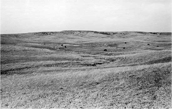
Figure 15--Slumping of the Blue Hill Shale Member of the Carlile Shale in the NE sec. 5, T. 11 S., R. 15 W. Persistent, heavy rains in summer 1993, resulted in mass wasting of the Blue Hill at many localities where the shale is capped by the Fort Hays Limestone Member of the Niobrara Chalk on steeper slopes.
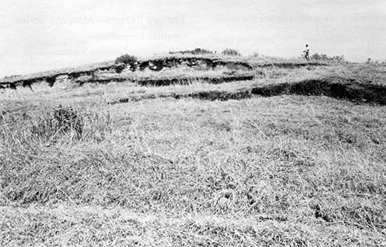
Figure 16--Outcrop of the Blue Hill Shale Member of the Carlile Shale in the roadcut and road surface along the SW boundary, secs. 5 and 8, T. 11 S., R. 15 W. The overlying Fort Hays Limestone Member of the Niobrara Chalk can be seen in the road at the top of the hill (arrow).
Codell Sandstone Member--Bass (1926) named and described the Codell sandstone bed from a sandstone overlying the Blue Hill Shale Member in the vicinity of Codell, along the Saline River valley in Ellis County. The Codell was elevated to member status by Dane and Pierce (1933), but was relegated to informal rank of zone within the Blue Hill Shale member by Moore et al. (1951). Informal rank persisted until the Codell was re-elevated to member status by Merriam (1957) and Jewett (1959).
As defined, the Codell Sandstone Member is a fine-grained, silty sandstone that is locally shaly. The lower contact with the Blue Hill Shale Member is conformable and gradational, whereas the upper contact with the Fort Hays Limestone is unconformable and abrupt. Fossils are rarely found in the Codell Sandstone. In Russell County, the total thickness of the Codell Sandstone is unknown. The only known exposure of the Codell recognized in this study, a result of recent slumping, is located in the SE sec. 5, T. 11 S., R. 15 W. (fig. 17).
Figure 17--Outcrop of the Codell Sandstone in SE sec. 5, T. 11 S., R. 15 W., at an exposure created by recent slumping of underlying Blue Hill Shale Member. At this locality, approximately 2 m (6.5 ft) of the Codell is exposed. The lower contact of the Fort Hays Limestone Member of the Niobrara Chalk is also visible in the exposure.
Niobrara Chalk
Meek and Hayden (1862) named the Niobrara Chalk from exposures of chalky limestone and calcareous marl in the Niobrara River valley of northeastern Nebraska. The formation was later divided into the Fort Hays Limestone and Smoky Hill Chalk Members by Logan (1897). Subsequently, the stratigraphy and paleontology of the Niobrara in western and central Kansas were described and analyzed by a number of researchers (e.g., Bass, 1926; Elias, 1931; Moss, 1932; Russell, 1929; Cobban and Reeside, 1952; and Hattin, 1982). The Niobrara crops out only in the extreme northwestern corner of Russell County where a maximum of 100 ft (30 m) remains. The lower 45-50 ft (14-15 m) consists of the Fort Hays Limestone, and the remainder is the Smoky Hill Chalk Member (Rubey and Bass, 1925). On the geologic map of the county (Johnson and Arbogast, 1996), the two members are differentiated and mapped as Knf and Kns, respectively.
Fort Hays Limestone Member--Unconformably overlying the Blue Hill Shale is the Fort Hays Limestone Member. The Fort Hays Limestone is characterized by thick to very thick beds of resistant chalky limestone that is light gray to medium gray or light olive gray and that weathers yellowish gray, grayish or pale grayish orange, or almost white. Thin beds of bentonite and shale separate many of the limestone beds, which consist largely of homogeneous, micrograined carbonate rock that have been thoroughly bioturbated. Increased sand content at the base of the Fort Hays apparently reflects reworking of Codell sands at the onset of the Niobrara transgression (Hattin and Siemers, 1978). Macrofossils (e.g., Inoceramus deformis, Inoceramus browni) and trace fossils (e.g., Teichichnus, Planolites) are found in the member. In Russell County, the Fort Hays is well exposed at only two localities, a slump in the NW sec. 5, T. 11 S., R. 15 W. (fig. 17) and a quarry in the NW sec. 6, T. 11 S., R. 15 W. (fig. 18). The contact with the overlying Smoky Hill Chalk Member was difficult to locate precisely due to the lack of a suitable outcrop.
Figure 18--Gravel quarry in the NW sec. 6, T. 11 S., R. 15 W., exposing the upper pan of the Fort Hays Limestone Member of the Niobrara Chalk. The Niobrara Chalk is confined to the northwestern four sections of RusselJ County.
Smoky Hill Chalk Member--The Smoky Hill Chalk Member has been intensively studied by Hattin (1982). In Kansas, the Smoky Hill outcrop extends northeasterly 190 mi (306 km) from north-central Finney County to northeastern Jewell County on the Nebraska border. The type area is in western Kansas and consists of a composite section from 12 localities that is about 596 ft (182 m) thick. The Smoky Hill Member lies conformably over the Fort Hays Limestone Member and is dominated by fecal-pellet-speckled shaly chalk, which is Light olive gray to olive gray. More than 100 bentonite seams, many of which have weathered to iron oxide and gypsum, have been recognized in the Smoky Hill by Hattin; they are more abundant in the lower part of the member. Vertebrate and invertebrate fossil material is common in the chalk, with the most obvious fossils being Inoceramus grandis and Pseudoperna congesta. In the very northwestern corner of the county, the Smoky Hill consists of thin remnants that cap the higher hills held up by the Fort Hays Limestone. The best exposure occurs in a quarry located in the NW sec. 6, T. 11 S., R. 15 W. (fig. 19), which also contains the Fort Hays Limestone.
Figure 19--Smoky Hill Chalk Member of the Niobrara Chalk exposed in a gravel quarry in the NW sec. 6, T. 11 S., R. 15 W. Only the lower 2 m (6.5 ft) of the Smoky Hill is exposed in Russell County, and the contact with the. Fort Hays Limestone Member is approximate.
Tertiary System--Miocene Series
Ogallala Formation
The Ogallala Formation is a heterogeneous complex of massive to crossbedded alluvium deposited during the Miocene and early Pliocene by streams originating in the Rocky Mountain region. The Ogallala covers most of the High Plains and is the primary aquifer in the region. A major discontinuity separates the Ogallala from both the underlying Cretaceous deposits and overlying unconsolidated sediments of the Quaternary System in Russell County.
Darton (1899) first proposed the name Ogallala based on exposures near Ogallala Station in southwestern Nebraska. Subsequently, in a report on the geology of Hamilton and Kearny counties in southwestern Kansas, Darton (1920) identified a general type locality in the vicinity of Ogallala Station. Detailed studies of the Ogallala in Kansas, which included designation of a precise type locality near Ogallala Station in Nebraska, were conducted by Elias (1931, 1932, 1935, 1942). The Nebraska Geological Survey later classified the Ogallala as a group and subdivided it into four formations.
The age of the Ogallala has been somewhat controversial. Darton (1899) argued that the Ogallala was late Tertiary. Based on work in Wallace County, Elias (1931) believed that mammalian fauna in the Ogallala indicated a late Miocene to early Pliocene age. Boellstorff (1976) obtained a late Miocene age of 7.6 ± 0.7 Ma from volcanic glass shards (fission-track dating) collected at the Ogallala type section. In Texas, where both fluvial and eolian facies in the Ogallala have been observed, deposition was recognized at about 8.5 Ma (Gustavson and Winkler, 1988). According to Voorhies (1990), the onset of Ogallala time in Nebraska appears to correlate with the medial Barstovian land mammal age at about 14 Ma. Voorhies also obtained a range of fission-track ages in Nebraska from 13.6 ± 1.3 Ma to 5.0 ± 0.2 Ma, which suggest that a medial age of 9.5 Ma (14-4.5 Ma) is indicated for the Ogallala in the region.
Three members--The Kansas Geological Survey recognizes three members within the Ogallala Formation (Bayne and O'Connor, 1968), which have been differentiated and correlated by floral and faunal remains, volcanic ash petrology, and gross lithology. The lowermost memher is the Valentine, which is confined to Cretaceous bedrock valleys, and consists of medium- to fine-grained sands and gravels that are greenish gray to pink and pale tan. Layers of volcanic ash and bentonite are common as are silica-cemented sand and gravel, diatomaceous marl, and a diagnostic fossil grass seed (Stipidium commune).
Overlying the Valentine is the Ash Hollow Member, which consists of lithologically heterogeneous, generally coarse, gray to pink sand and gravel that crop out in bedrock valleys and on valley side slopes and divides. The Ash Hollow contains rich floral zones (e.g., Krynitzkia coroniformis seed zone), molluscan assemblages, and abundant volcanic ash beds (particularly in the lower half) that are cemented by silica locally to form erosion-resistant lentils of sandstone and are weakly cemented with carbonate at other localities to form mortar beds.
The uppermost member of the Ogallala is the Kimball, which consists largely of highly calcareous and predominantly gray fine- to medium-grained sand, silt, and clay that accumulated after bedrock valleys were filled by the Valentine and Ash Hollow Members. As a result, the Kimball consists of a thin, unconfined mantle of sediments on the landscape. Capping the Kimball is a dense pink to white pisolitic nodular caliche (calcrete) that is 3 ft (0.9 m) thick. The member has an observed thickness ranging from 2.5-44 ft (0.76-13 m) and is easily differentiated by distinctive plant fossils and molluscan assemblages that occur in the basal part.
The Ogallala Formation is neither a major nor pervasive geologic unit in Russell County. In fact, the correlation of the Ogallala in Russell County by Rubey and Bass (1925) and Frye and Brazil (1943) is extremely tentative, based on lithologic similarities and recognition of the formation to the north, south, and west of Russell County. Uncertainty exists because cemented sand and gravel in Russell County does not correlate in elevation and gradient with known Ogallala outcrops immediately to the west in Ellis County (Frye and Brazil, 1943). According to Frye and Brazil (1943), however, cemented sand and gravel deposits in the uplands of Russell County are undoubtably older than unconsolidated Pleistocene sand and gravel deposits found at lower elevations, suggesting to them an uppermost Pliocene or lowermost Pleistocene age.
Although confusion remains concerning the age of cemented upland sand and gravel deposits in Russell County, their lithologic similarity with known Tertiary deposits to the west favors tentative correlation with the Ogallala Formation, at least until more is known. It is impossible, however, to determine positively which member of the Ogallala occurs in Russell County. As a result, the deposits are not differentiated on the geologic map of the county (Johnson and Arbogast, 1996) and are collectively designated To. Two areas of outcrop for the Ogallala occur in Russell County. The largest area is the very northwestern corner of the county in the vicinity of the Niobrara Chalk outcrops, where the Ogallala consists of thin, isolated remnants high on valley walls. The best exposure of the Ogallala in this area is in a roadcut in the SE sec. 9, T. 11 S., R. 15 W. (fig. 20). An isolated exposure is in a gravel quarry in the NE sec. 13, T. 14 S., R. 14 w., southeast of Russell (fig. 21). At both localities, the Ogallala consists of massive to cross bedded sand and gravel, and grit and clay that are locally cemented by calcium carbonate. Clay balls were also recognized in the deposits, particularly in the northwestern outcrop area.
Figure 20--Exposure of cemented alluvial sand and gravel, tentatively assigned to the Ogallala Formation, in the uplands of the SE sec. 9, T. 11 S., R. 15 W. In this roadcut, the Ogallala unconformably overlies the Blue Hill Shale Member of the Carlile Shale (arrow).
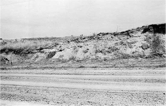
Figure 21--Cross bedded and cemented alluvial sand and gravel, tentatively assigned to the Ogallala Formation, in a quarry in the NE sec. 13, T. 14 S., R. 14 W.
Quaternary System--Pleistocene Series
Classically, the Pleistocene has been divided on the basis of four glacial advances or stages: the Nebraskan, Kansan, Illinoian, and the Wisconsinan. Due to the complexity of the stratigraphic record and faulty correlations by early researchers, however, the traditional Pleistocene chronology has largely been abandoned in recent years. Many of the early stratigraphic correlations, for example, were made on the basis of a single volcanic ash marker bed, the Pearlette (Frye and Leonard, 1952; Schultz and Martin, 1970). In fact, three separate Pearlette ashes and three other ashes have been differentiated (table 2) in the central Great Plains on the basis of petrographic and chemical characteristics (Izett et al., 1970; Izett, 1981; Izett and Wilcox, 1982) and fission-track dating (Boellstorff, 1973, 1974, 1976; Naeser et al., 1973; Carter et al., 1990; Ward et al., 1993).
Table 2--Fission-track dated volcanic ashes of major stratigraphic significance in the Central Plains (Nebraska, Kansas, and Oklahoma).
| Ash | Alternate names |
Source area |
Representative age (x106 yr) |
|---|---|---|---|
| Pearlette O | Pearlette restricted, Lava Creek B, Cudahy, Hanford |
Lava Creek Tuff, Member B, Yellowstone |
0.610 |
| Bishop | Mount Clare | Bishop Tuff | 0.738 |
| Tsankawa | Toledo & Valles caldera, NM | 1.12 | |
| Pearlette S | Coleridge, Mesa Falls |
Mesa Falls Tuff, Yellowstone |
1.27 |
| Guaje | Toledo & Valles caldera, NM | 1.45 | |
| Pearlette B | Huckleberry, Ridge, Borchers |
Huckleberry Ridge Tuff, Yellowstone |
2.01 |
| Sources: Boellstorff (1976), Izett (1981, 1982), Izett and Wilcox (1982), Richmond and Fullerton (1986), and Ward (1991). | |||
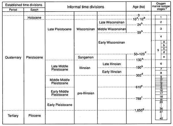
An informal scheme of geologic divisions and associated chronology for the Quaternary of the United States has been assembled using various stratigraphic markers (e.g., Pearlette O volcanic ash, glacial tills, Matuyama-Bruhnes magnetic polarity reversal) and the marine 18O record (fig. 22). The Pliocene-Pleistocene boundary was set at 1.65 Ma, in accordance with the corresponding radiometric-age estimate from the Virca section in Italy (Aguirre and Pasini, 1985). Richmond and Fullerton (1986) subdivided the Pleistocene into early, middle, and late, with the middle being further divided into early middle, middle middle, and late middle Pleistocene. Pleistocene time prior to the Illinoian is referred to as pre-Illinoian on the basis of the 18O record, which indicates that ten glaciations (seven Pleistocene, three Pliocene) occurred prior to 302 ka rather than two, as proposed in classical theory. A more detailed discussion of the Pleistocene chronology in Kansas is found in Bayne and O'Connor (1968) and Johnson (1993).
Figure 22--Quaternary time scale. Modified from Richmond and Fullerton (1986, p. 6). Notes: (a) Pleistocene-Holocene boundary after Hopkins (1975). (b) Ages of the marine isotope boundaries taken from Martinson et al. (1987); values were derived using the Milankovich orbital tuning techniques. (c) The Sangamon-Wisconsinan (Interglacial-Glacial) boundary is yet uncertain and may be diachronic (Johnson et al., 1991; Curry and Follmer, 1992), 75 ka (Fulton, 1984, 1986), 100 ka (Terasmae and Dreimanis, 1976), and 122 ka (Richmond and Fullerton, 1986). The age of 116 ka has been adopted by Clark et al. (1993). (d) Ages of the marine isotope boundary interpreted by Richmond and Fullerton (1986) from graphic data presented by R. G. Johnson (1982). (e) K-Ar age of the Lava Creek tuff and Pearlette O volcanic ash bed (Izett and Wilcox, 1982). (f) Astronomical age of the Matuyama-Bruhnes magnetic polarity reversal derived by R. G. Johnson (1982) and adopted by Richmond and Fullerton (1986). (g) Age of the Pliocene-Pleistocene boundary at the Virca, Italy, section (Aguirre and Pasini, 1985).
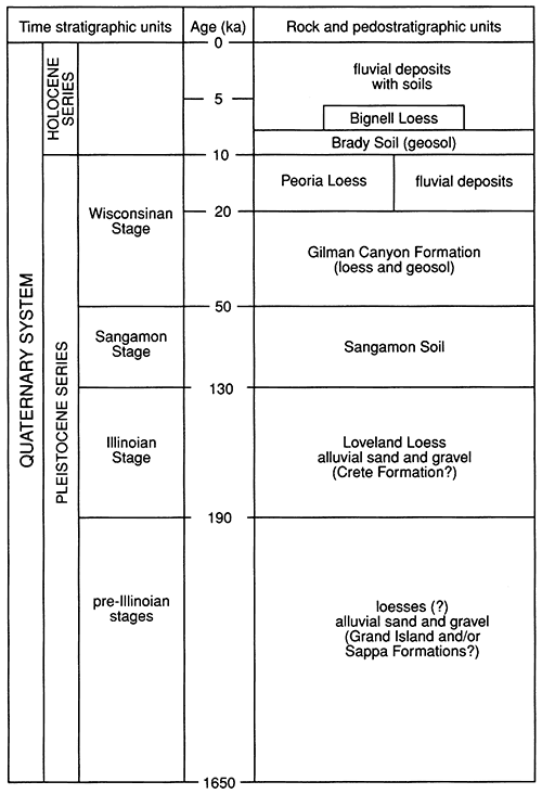
The late Quaternary stratigraphic succession for Russell County is represented in fig. 23. Pre-Illinoian deposits are tentatively recognized in the county but are spatially isolated and limited to the upland margins of major valleys. Illinoian deposits occur more extensively but are also isolated in upland and valley contexts. Wisconsinan sediments are widespread, with appreciable surface expression on both the uplands and along stream valleys. Holocene deposits are very common and are recognized in both upland and alluvial settings.
Figure 23--Late Quaternary stratigraphic succession in Russell County. Modified from Johnson (1993).
Pre-Illinoian deposits
Isolated pre-Illinoian deposits of unconsolidated gravel, sand, and silt, with lentils of volcanic ash, are found throughout northwestern Kansas as terrace-fill remnants in major valleys. Originally, these nonglacial sediments were included within the Meade Formation and were thought to be of classical Kansan age. The Meade Formation was later subdivided into the Grand Island and Sappa Members (Frye and Leonard, 1952) based on stratigraphic nomenclature derived in Nebraska by Lugn (1934, 1935) and Condra et al. (1950). Subsequently, the name of Meade Formation was abandoned in favor of elevating the Grand Island and Sappa units to the formational level (Bayne and O'Connor, 1968).
Despite a lack of absolute age control (e.g., fission-track, thermoluminescence) validating the continued use of "Grand Island" and "Sappa" as formation names, their use persists. The Grand Island Formation, as it is defined, consists of gravel, sand, and minor amounts of silt approximately 20 ft (6.1 m) thick that are present in northwestern Kansas beneath a highly dissected terrace in major stream valleys. Conformably overlying the Grand Island is the Sappa Formation, which is composed of alluvial silt and small amounts of sand with lentils of Pearlette volcanic ash (Frye and Leonard, 1952).
Isolated deposits of unconsolidated sand, silt, and gravel, potentially correlating to the Grand Island and Sappa Formations, as they are presently defined, are located in Russell County along the Smoky Hill River, Saline River, and their major tributaries (e.g., Wolf Creek). These deposits were originally described by Logan (1897), who referred to them as the "Salt Creek gravel beds." Rubey and Bass (1925) recognized two gravel beds, an upper and a lower one, in the Saline River valley. The lower gravel bed, which corresponds to Logan's (1897) Salt Creek gravel beds, occurs consistently about 50 ft (15.3 m) above the modem floodplain; it is approximately 2 ft (0.6 m) thick. The upper gravel bed is found between 40-70 ft (12.2-21.4 m) above the modern floodplain and is about 10 ft (3 m) thick. Gravel beds similar to the upper gravel bed in the Saline valley were also recognized by Rubey and Bass (1925) along the Smoky Hill and its major tributaries. Frye and Brazil (1943), on the basis of fossil assemblage and terrace elevation, suggested that the gravel beds in Russell County correlate to the McPherson Formation farther downstream.
Although no absolute time control exists, upland gravel deposits in major stream valleys of Russell County are thought to be of pre-Illinoian age and may correlate to the Grand Island and Sappa Formations, if continued use of this nomenclature is indeed appropriate. On the geologic map of the county (Johnson and Arbogast, 1996), the Grand Island and Sappa Formations are undifferentiated and included within the map unit Qg. A typical example of one such gravel bed, exposed in the SE sec. 30, T. 14 S., R. 11 W. within the Smoky Hill River valley, is depicted in fig. 24.
Figure 24--Alluvial sand and gravel of Pleistocene age in a quarry located on the north side of the Smoky Hill River in the SE sec. 30, T. 14 S., R. 11 W. The gravel bed unconformably overlies the Dakota Formation at this locality.
Illinoian deposits
All Pleistocene deposits of Illinoian and younger age were originally included within the Sanborn Formation. As a result, the formation encompassed sediments from two glacial stages and substages as well as two prominent discontinuities, the Sangamon and Brady soils. The name "Sanborn" was derived from unconsolidated deposits in northwestern Cheyenne County, Kansas, by Elias (1931). Frye and Fent (1947) subsequently designated a Sanborn type section with subdivision into three members: the Loveland silt (Illinoian), the Peoria silt (Wisconsinan), and the Bignell silt (Holocene). A fourth member, the Crete sand and gravel, which underlies the Loveland silt, was recognized by Frye and Leonard (1949). Although the Sanborn Formation was originally thought to be a convenient term for mapping purposes, the term was abandoned in 1959 by the Kansas Geological Survey because the formation could be subdivided into discernable, mappable units and could be confused with the Sanborn Group, a thick siltstone exposed in Meade County, Kansas, which has been dated (fission-track dating) to 1.08 Ma (Carter and Ward, 1991). Instead, members of the Sanborn Formation were elevated to formational rank (Jewett, 1959), and phases were subsequently defined (Bayne and O'Connor, 1968).
Crete Formation--The Crete sand and gravel is an alluvial deposit, probably reflecting several cut and fill sequences, that is presumably of Illinoian age. Originally, the Loveland unit included both eolian and alluvial sediments (Lugn, 1935), but Condra et at. (1947) introduced the name "Crete Formation" in Nebraska in order to differentiate the alluvium from the loess. Based on recent data from Nebraska, Wayne and Aber (1991) suggested that the names "Crete" and "Grand Island" may refer to the same sedimentary unit. As a result, they favored discontinuing use of the name "Crete Formation."
The Crete Formation, as it is defined in Kansas, is widely recognized in the north-central pan of the state, where it consists locally of gully fills and as terrace deposits on the north side of major river valleys (Frye and Leonard, 1952, p. 112). Typically, Crete lithology is consistent with that of the drainage basin within which the deposits occur. In Russell County, the Crete Formation is tentatively identified as underlying the Loveland Loess at the Beisel-Steinle site (Diekmeyer, 1994), a roadcut in the NW sec. 27, T. 14 S., R. 11 W. (fig. 25). In addition, it may be exposed in gravel pits along the Smoky Hill River, Saline River, and their major tributaries. Nevertheless, the Crete is not differentiated from other, presumably older, Pleistocene sand and gravel deposits in Russell County and is included within the map unit Qg (Johnson and Arbogast, 1996).
Figure 25--The Beisle-Steinle site (Diekmeyer, 1994) in the NW sec. 27. T. 14 S., R. 11 W. Poorly exposed in the roadcut are four late Quaternary stratigraphic units, from bottom to top: alluvial sand and gravel of the Crete Formation (A), Loveland Loess (L), Sangamon Soil (S), and Gilman Canyon Formation (G).
Loveland Loess--The Loveland Loess is the most pervasive pre-Wisconsinan loess in the central United States. Shimek (1909) first identified the Loveland in exposures along the eastern bluff of the Missouri River northeast of Loveland, Iowa. Subsequently, Lugn (1935) recognized and described an eolian and alluvial component to the Loveland in Nebraska. Condra et al. (1950) later elevated the alluvial component to formational rank, naming it the Crete Formation. Recently, the Loveland Loess has been described throughout the Missouri, Mississippi, and Ohio River basins (e.g., Reed and Dreeszen, 1965; Ruhe, 1969; Willman and Frye, 1970; Ruhe and Olson, 1980) and has been recognized as far south as Arkansas and Mississippi (McCraw and Autin, 1989).
Loveland Loess consists of carbonate-enriched eolian silt that accumulated during the Illinoian Stage between about 300 ka and 130 ka (fig. 22). The Loveland Loess is yellowish brown or reddish brown, with increased red hues toward the top of the formation due to development of the Sangamon Soil. Several paleosols of variable development, including the Sangamon Soil, have been recognized in the Loveland (Frye and Leonard, 1954; Feng, 1991; Feng et al., 1994a, 1994b). Four zones of carbonate enrichment, occurring at about 410-360, 330-290, 250200, and 130-95 ka, were interpreted by Feng et al. (1994a, 1994b) to be soil-forming intervals associated with interglacial stages, the latter two of which would be associated with the Illinoian Stage. The thickest accumulations of Loveland Loess in Kansas are in the north-central part of the state and measure up to 49 ft (15 m). Elsewhere it is typically less than 12 m (39 ft) thick (Johnson, 1993).
In Russell County, the Loveland Loess was not differentiated from other loess formations, but it is recognized at the Beisel-Steinle site (fig. 25). The absolute age of the Loveland is unknown for Russell County, but Oviatt et al. (1988) reported thermoluminescence (TL) ages of 136 ka and 130 ka from the upper part of Loveland loess near Milford in northeastern Kansas. At the Barton County sanitary landfill, P. Maat and W. C. Johnson (unpublished data) obtained an age of 212 ka from a pre-Sangamon soil zone in Loveland Loess, whereas Feng (1991) dated the upper Loveland Loess at 69 ka.
Sangamon Soil--The Sangamon Soil is a strongly developed paleosol or complex of paleosols distributed throughout the midcontinent, including the states of Indiana (Hall, 1973; Ruhe et al., 1974; Ruhe and Olson, 1980), Illinois (Bushue et al., 1974; Follmer, 1979), Iowa (Simonson, 1941, Ruhe, 1956, 1969), Nebraska (Schultz and Stout, 1945; Thorpe et al., 1951), and Kansas (Frye and Leonard, 1952). Initially recognized by Leverett (1899) to differentiate between the Illinoian and Wisconsinan deposits, the Sangamon is characterized by intense oxidation (vivid to pale reddish-brown colors), deep leaching, and high clay accumulation. Because of apparent time transgressiveness and the diachronous nature of the Sangamon Soil, the age of the soil is not precisely known. Estimates indicate, however, that it ranges from approximately 135 ka to 75 ka in age (e.g., Forman 1990; Forman et al., 1992; Johnson et al., 1990; Maat and Johnson, 1996).
The Sangamon Soil probably should be considered a pedocomplex, with several soils representing significant temporal and environmental variability welded together, rather than a single soil that developed under unique environmental conditions (Schultz and Tanner, 1957; Fredlund et al., 1985; Morrison, 1987). From his research in Brown County, Schaetzl (1986) observed that the Sangamon appears to be a strongly developed Ultisol or Mollisol.
Originally known in Kansas as the "soil in the Sanborn formation" (Hibbard et al., 1944) and the Loveland soil (Frye and Fent, 1947), the Sangamon has been extensively studied in the northeastern part of the state (e.g., Frye and Leonard, 1949, 1952; Caspall, 1970, Schaetzl, 1986) but has been recognized elsewhere (Bayne and O'Connor, 1968). Recently, in a study of the Sangamon Soil at Barton County, Kansas, Feng et al. (1994a, 1994b) concluded from chemical and physical characteristics that the soil formed in a warm, moist climate, resulting in strong chemical weathering. In Russell County, the Sangamon Soil has been identified at the Beisel-Steinle site (fig. 25) and is assumed to exist elsewhere in the county. It is not, however, differentiated from the other late Pleistocene loesses and is included within the map unit Ql on the geologic map of the county (Johnson and Arbogast, 1996).
Wisconsinan deposits
Since it is the most recent glacial episode, the Wisconsinan has the greatest chronostratigraphic resolution. Radiocarbon dating indicates that the Wisconsinan glaciation began 79,000 to 70,000 years ago. An early chronology, based on deposits in the state of Illinois, recognized five substages in the Wisconsinan: the Altonian (70,000-28,000 yr B.P.), Farmdalian (28,000-22,000 yr B.P.), Woodfordian (22,000-12,500 yr B.P.), Twocreekan (12,500-11,000 yr B.P.), and Valderan (11,000-5,000 yr B.P.) (Willman and Frye, 1970; Frye and Willman, 1973). In Kansas, Frye and Leonard (1965) used the Brady Soil as a chronostratigraphic marker to divide pre-Bradyan time (Altonian, Farmdalian, Woodfordian, and Twocreekan substages) from post-Bradyan time (Valderan substage).
Subsequent research in type areas of Illinois and Wisconsin has placed the age of the Sangamon- Wisconsin boundary at about 50 ka (McKay, 1979; Leigh, 1991, 1994; Curry and Folmer, 1992). The boundary appears, however, to be time transgressive (Johnson et al., 1991), which accounts for the lack of consistency in the limited chronologie data. In fig. 22, the Wisconsinan chronology has been subdivided so as to include Early, Middle, and Late Wisconsinan divisions, with the stage extending from about 116 ka to 10 ka (marine isotope stages 5d through 2; Clark et al., 1993). Wisconsinan rock-stratigraphic units recognized in Russell County consist of the Gilman Canyon Formation (loess) and the Peoria Loess.
Gilman Canyon Formation. The Gilman Canyon Formation, a middle Wisconsinan loess and valley fill, was first recognized in Nebraska by Reed and Dreeszen (1965). It is the apparent chronostratigraphic equivalent to the Pisgah Formation in western Iowa (Bettis, 1990, Forman et al., 1992) and the Roxana Silt (Leigh and Knox, 1993, Leigh, 1994), which has been recognized in an area extending from Minnesota and Wisconsin to Arkansas. In Kansas and Nebraska, the upper part or all of the Gilman Canyon Formation is usually silty, leached of calcium carbonate, commonly bioturbated, and dark colored as a consequence of heavy enrichment of pedogenic organic carbon. The Gilman Canyon Formation was once thought to be the attenuated A horizon of the Sangamon Soil (Thorpe et al., 1951; Reed and Dreeszen, 1965), but radiocarbon time control and stratigraphic information indicate that it is a geosol or a composite geosol (Johnson, 1993) because it is a laterally traceable, mappable, pedostratigraphic unit with a consistent time-stratigraphic position (Morrison, 1965; North American Commission on Stratigraphic Nomenclature, 1983, p. 865).
In Illinois, radiocarbon ages based on organic materials from within early Wisconsinan loess range from 40,000 to 31,000 yr B.P. Based on these ages, McKay (1979) extrapolated that loess deposition began about 45,000 yr B.P. Radiocarbon and TL ages from loess lying directly above the Sangamon Soil in Iowa range from 35 ka to 30 ka (Forman, 1990; Forman et al., 1992). Radiocarbon ages from the middle Wisconsinan Roxana silt in the Upper Mississippi River valley indicate that the loess unit was deposited between 50 ka and 27 ka (Leigh, 1991, 1994; Leigh and Knox, 1993).
Radiocarbon ages from the Gilman Canyon Formation range from approximately 38,000 yr B.P. near the base to about 20,000 yr B.P. at the top (May and Souders, 1988; Johnson et al., 1990; Johnson, 1993). The age of 38 ka is derived from a sample taken from the base of the Gilman Canyon geosol, not the base of the formation. Consequently, the age of the basal part of the formation is perhaps close to 50 ka, which would agree with that of the Roxana silt (Leigh, 1991; Leigh and Knox, 1993). In Nebraska and Kansas, the Gilman Canyon Formation has been dated at 54 localities (11 of which are in Kansas).
Limited textural data and description of the Gilman Canyon Loess at the Buzzard's Roost type section was provided by Reed and Dreeszen (1965, p. 62): "Upper 12 inches (31 cm) is medium dark gray, slightly humic, silt; middle 3 feet 7 inches (1.1 m) is dark brownish-gray, humic, soil-like silt; entire thickness is noncalcareous ... 5 feet 9 inches (1.8 m)." The bimodal distribution of the humus indicates that two periods of relative stability and low accumulation are separated by a period of increased accumulation. As a result, the Gilman Canyon is often expressed as one or more cumulic A horizons. May and Souders (1988) recognized three distinct organic zones in an expanded valley-fill section in Nebraska and two organic zones have been recognized at the Eustis Ash Pit in south-central Nebraska by Johnson et al. (1993). These observations indicate that the Gilman Canyon accumulated at a rate sufficient for continuous pedogenesis <0.08 mm/yr), but with a variable intensity.
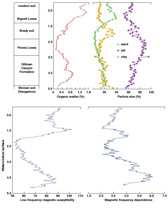
Due to the lack of exposures, the Gilman Canyon Formation has been positively identified at only one locality in Russell County, the Beisel-Steinle site (figs. 25, 26). Two peaks exist in the organic matter curve, indicating that two distinct episodes of soil formation, separated by a brief period of increased deposition, occurred (fig. 27). Texturally, the Gilman Canyon Loess consists largely of silt, with lesser, but equal, percentages of sand and clay. Two magnetic parameters. susceptibility and frequency dependence, have been employed as surrogates of weathering and soil formation. The bimodal organic matter distribution is corroborated by frequency dependence, an indicator of pedogenically produced fine sediments. These observations are consistent with data previously noted from the type locality (Reed and Dreeszen, 1965) and the Eustis Ash Pit of southwestern Nebraska (Johnson et al., 1993).
Figure 26--Upper part of the Beisle-Steinle site (Dickmeyer, 1994) in the NW sec. 27, T. 14 S., R. 11 W. Exposed in the upper pan of the site are four late Quaternary stratigraphic units-from bottom to top, Gilman Canyon Formation (G), Peoria Loess (P), Brady Soil (Br), Bignell Loess (Bi)-and modem surface soil (M).
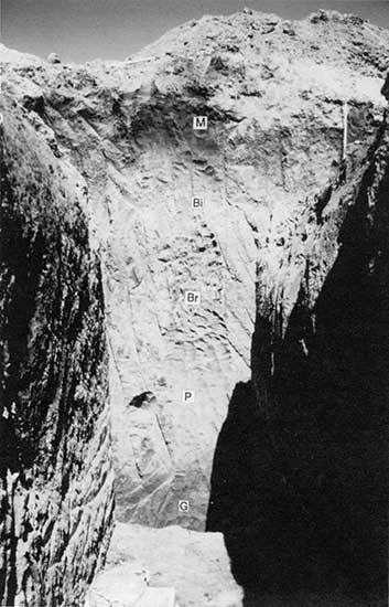
Figure 27--Stratigraphy, percent organic matter, panicle size, and magnetic susceptibility (10-8 m3/kg) and frequency dependence (%) of the Beisle-Steinle site in the NW sec. 27, T. 14 S., R. 11 W.
Four radiocarbon ages were determined from samples collected in the Gilman Canyon Loess at the Biesel-Steinle site (table 3). Based on the position of the lowest sample, soil development began shortly before about 32,800 years ago. The age of 22,590 ± 270 yr B.P. on the uppermost part of the formation indicates approximately when Gilman Canyon time ended. A radiocarbon age of 34,340 ± 110 yr B.P. (Tx-7710) was obtained from an exposure of the Gilman Canyon soil developed within alluvium of the Saline River valley in the eastern part of adjacent Ellis County (W. C. Johnson, unpublished data), indicating that an alluvial facies of the Gilman Canyon Formation may also be preserved in Pleistocene terraces of the Saline River valley in Russell County.
Table 3--Radiocarbon ages from the Beisel-Steinle site (reported in Diekmeyer, 1994).
| Depth (m) |
Lab number |
Uncorrected age (yr B.P.) |
δ13C (‰) |
Corrected age (yr B.P.) |
|---|---|---|---|---|
| 1.45-1.50 | Tx-8183 | 3,030 ± 50 | -11.5 | 3,250 ± 50 |
| 2.40-2.45 | Tx-8186 | 11,270 ± 110 | -20.1 | 11,350 ± 110 |
| 3.70-3.75 | Tx-8184 | 22,440 ±260 | -15.9 | 22,590 ± 270 |
| 4.25-4.30 | Tx-8185 | 27,400 ±430 | -14.4 | 27,580±440 |
| about 4.2 | Tx-7709 | 27,220 ± 480 | -14.2 | 27,380 ±490 |
| 4.95-5.00 | Tx-8187 | 32,620 ± 1060 | -14.1 | 32,780 ± 1080 |
Carbon isotope fractionation analyses have proved to be of use in determining past vegetation and associated climatic conditions. The carbon composition (13C/12C) of the organic matter produced by plants is highly correlated with the type of photosynthetic pathway: C3 pathway plants (cool, moist adapted) have an average δ13C value of -27‰ (parts per thousand), while C4 pathway plants (warm, dry adapted) have an average value of -14‰ (Krishnamurthy et al., 1982). Accordingly, the time series of δ13C left in the loess by the plants (namely grasses) should be a proxy record of climate. Proxy data for vegetation and climate associated with humate-derived δ13C values obtained from loess samples collected at the Biesel-Steinle site (fig. 27). These data suggest that the plant ecology of the Gilman Canyon Loess was dominated by C4-type grasses, reflecting a relatively warm, possibly dry climate (Johnson, 1993). Opal phytolith data (Fredlund et al., 1985; Fredlund and Jaumann, 1987; Johnson et al. 1994) and isotopic data (Fredlund, 1993; Johnson et al., 1994) from sites located elsewhere in the region indicate that a panicoid-dominated (C4) grassland existed in an environment suitable for moist, temperate-adapted tall grasses during accumulation of Gilman Canyon Loess.
Although recognized at only one site in Russell County, the Gilman Canyon Formation is assumed to be present elsewhere in the county, specifically on broad interfluves where it is buried by Peoria Loess. The Gilman Canyon Formation is not differentiated from other loesses in Russell County and is included within the map unit Ql on the geologic map of the county (Johnson and Arbogast, 1996).
Peoria Loess--The name "Peoria" was first proposed by Leverett (1899) for deposits of an interglacial period that separates the Iowan and Wisconsinan glacial stages. When Alden and Leighton (1917) demonstrated that the Peoria is younger than the Iowan, the name "Peoria" became associated with a loess rather than a weathering interval. Several names have been used for post-Farmdalian loess in the central United States. Ruhe (1983), for example, preferred the term "late Wisconsin loess" because of correlation uncertainties from one region to another.
The Peoria Loess is typically calcareous, massive, light-yellowish-tan to buff silt that usually overlies the Loveland Loess or an approximate equivalent of the Gilman Canyon Formation. Ruhe (1983) noted three major characteristics of the Peoria, i.e., that it thins downwind of the source area, systematically fines in particle size downwind from the source area, and is time transgressive. Regarding the latter, Ruhe (1969) found that the age of the soil beneath the Peoria Loess decreases from 24,500 yr B.P. near the Missouri River to about 19,000 yr B.P. eastward across southwestern Iowa. Similarly, the base of the loess decreases in age from 25,000 to 21,000 yr B.P. along a transect in Illinois (Kleiss and Fehrenbacher, 1973). Ages from the top of the loess range from 12,500 yr B.P. in Illinois (McKay, 1979) to 14,000 yr B.P. in central Iowa (Ruhe, 1969). Deposition of the Peoria Loess was not continuous, as evinced by stratigraphic breaks such as that marked by the Jules soil in Illinois (Frye and Willman, 1973; Frye et al., 1974, Ruhe, 1976; McKay, 1979) and the soil zones recognized in Iowa (Daniels et al., 1960; Ruhe et al., 1971).
In Kansas, the Peoria Loess is a reddish, yellowish, or tan-buff homogeneous, massive, locally fossiliferous, variably calcareous coarse silt to very fine sand to medium to fine silt and clay (Frye and Leonard, 1952). The source of the silt is not certain. In a review of available data, Welch and Hale (1987) concluded that loess deposits in Kansas were not derived from a single source, but rather from a combination of three sources: glacial-outwash river floodplains, present sand dune fields, and erosion of the Ogallala Formation. In Phillips County, the Peoria contains moderate but variable amounts of sand with increasing amounts of clay. According to Johnson (1993), this trend may have resulted from increased clay influx from the southwest when atmospheric circulation patterns shifted as the Laurentide ice sheet diminished (COHMAP members, 1988). Thickness of the Peoria ranges from 100 ft (30.5 m) along the Missouri River valley to 2 ft (0.6 m) in isolated patches elsewhere. Where accumulation is less than 2 ft (0.6 m), the Peoria is considered to be unrecognizable because it is incorporated into the existing surface soil.
Although visible soil zones such as those recognized in Illinois (Frye and Willman, 1973; Frye et al., 1974; Ruhe, 1976; McKay, 1979) and Iowa (Daniels et al., 1960; Ruhe et al., 1971) have not been recognized in Kansas, lenses of plant remains, reflecting former stable surfaces, suggest that Peoria Loess deposition was discontinuous in the region. Remains of Picea (cf. glauca), which indicate a cool, moist environment, are common. Radiocarbon ages from these materials indicate two temporal clusters of deposition: 18-17 ka and 14-13 ka. The earliest interval occurred during the last glacial maximum, while the latter represents major deglaciation (Ruddiman, 1987). Atmospheric data obtained from Greenland ice-cores indicate a significant decrease in dust at about 13 ka (Paterson and Hammer, 1987), which may have resulted in relative surface stability, soil formation, and tree establishment in the central Great Plains (Johnson, 1993).
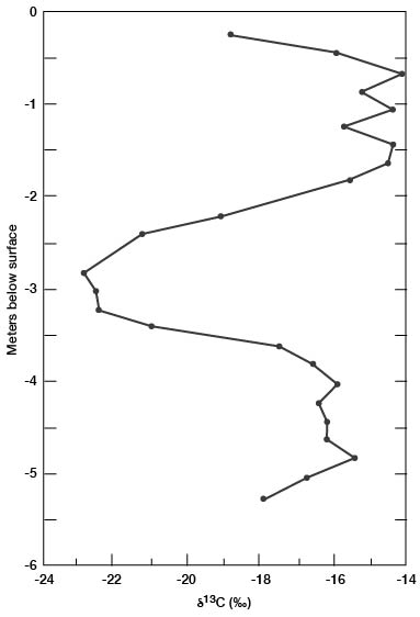
In Russell County, the Peoria Loess is undifferentiated from the other loesses and is included within the map unit Ql on the geologic map of the county by Johnson and Arbogast (1996). The only exposure where a significant thickness of Peoria Loess is recognized is the Beisle-Steinle site (fig. 25, 26). At this site, the Peoria consists dominantly of silt which was derived locally and from long-distance transport from the Platte River valley of Nebraska. In addition, organic matter decreases significantly from the underlying Gilman Canyon Formation, indicating that deposition of the Peoria was relatively continuous and rapid. The relatively low values for magnetic susceptibility and frequency dependence, a function of accumulation rates exceeding pedogenic rates, verify the relatively unweathered nature of the Peoria loess (fig. 27). Carbon isotope values (fig. 28) are smaller, indicating the C3 plant environment characteristic of the cool, moist climate of the Late Wisconsinan. The Peoria is probably the most widespread loess in the county, however, with thick, relatively continuous deposits likely on broad interfluves, especially those sloping to the south. Elsewhere, the Peoria probably consists of discontinuous patches that mantle heavily dissected upland terrain.
Figure 28--Changes with depth in humate-derived carbon isotope values (δ13C) determined from the backhoe trench excavated at the Biesel-Steinle site.
Quaternary System--Holocene Series
As defined, the Holocene comprises the last 10,000 years and began at a time of dramatic environmental change associated with disintegration of the Laurentide ice sheet. Although the Holocene is generally considered to be a diachronous geochronometric boundary with localized environmental change (e.g., Watson and Wright, 1980), recent research on the regional and subcontinental scale (e.g., Johnson and Martin, 1987; Johnson and Logan, 1990; and Johnson and May, 1992) has documented major pedogenesis, the first since Gilman Canyon time, in both alluvial and eolian/upland settings at about 10 ka.
Until recently, the Kansas Geological Survey recognized the Recent Stage of the Pleistocene Series (Bayne and O'Connor, 1968), which was defined as the last 5,000 years or the time since the end of the Valderan Substage of the Wisconsinan Stage. But the nature of the late Quaternary stratigraphic record in Kansas (Johnson, 1993) indicates that use of Recent Stage be abandoned in favor of Holocene (series status), in accordance with practice of the U.S. Geological Survey (Cohee, 1968). In a recent revision of the Kansas stratigraphic succession, the Kansas Geological Survey adopted Holocene as the name for the last ten thousand years (Baars, 1994).
Brady Soil--The Brady Soil was first named and described by Schultz and Stout (1948) at the Bignell Hill type locality, a roadcut exposure of loess and associated soils in the south valley wall of the Platte River of southwestern Nebraska. There, the Brady is developed within uppermost Peoria Loess and is overlain by the Holocene Bignell Loess. Subsequently, the soil name was adopted by researchers in Kansas (Frye and Fent, 1947; Frye and Leonard, 1949, 1951; Frye et al., 1949). The Brady Soil has been recognized in northeastern Kansas (Frye and Leonard, 1951; Caspall, 1970, 1972) but is regionally extensive only in the northwestern and west-central parts of the state where it occurs discontinuously. Where the overlying Bignell Loess is not visibly present and the surface has not been eroded during the Holocene, the Brady is expressed as an exposed paleosol, i.e., it has pedogenically integrated any post-Bradyan loess fall.
As defined, the Brady Soil is usually dark gray to gray brown and better developed than the overlying surface soil within the Bignell. The Brady can be strongly weathered both physically and chemically (Feng et al., 1994a, 1994b), resulting in a well developed Bt horizon and concentrations of illuviated carbonate in the C horizon. Recent radiocarbon dating of the Brady in both alluvial and upland environments indicates that pedogenesis occurred from about 10,500 yr B.P. to as recently as 8,500 yr B.P. (Johnson, 1993; Johnson et al., 1993).
The Brady is recognized only at the Beisel-Steinle site (fig. 26, 27). Texturally, the Brady contains significantly more clay than the Peoria Loess, which probably reflects in situ weathering of the Brady during pedogenesis. As expected, organic matter increases markedly in the Brady from the underlying Peoria Loess. The Brady Soil is expressed in both magnetic parameters: susceptibility defines the upper part of the solum, whereas frequency dependence probably articulates the textural B horizon of the lower solum (fig. 27). Carbon isotope values (fig. 28) increase progressively during Brady time, reflecting the shift from C3-type grasses and possibly trees to C4-type grasses characteristic of the region today.
The Brady Soil has been recently dated at several sites in Kansas and Nebraska (Johnson, 1993). From these radiocarbon data, it appears that Brady pedogenesis occurred between about 10.5 ka and 8.5 ka, although the chronology requires appreciable refinement. The Biesel-Steinle site is only the third site in Kansas to provide radiocarbon ages for the Brady Soil (table 3). The age of 11,350 ± 110 yr B.P. was derived from a sample collected immediately below the Brady Soil and probably predates initiation of Brady pedogenesis by about 1,000 years. A sample collected at the perceived top of the Brady dated at 3,250 ± 50 yr B.P. This was originally anticipated to date to about 9,000 yr B.P. but was much younger due to the incorporation of younger or modern carbon from the adjacent surface soil, which has apparently welded to the Brady Soil.
Although the Brady Soil is recognized at only one locality in Russell County, it undoubtably exists elsewhere in the county, most often on interfluves adjacent to large valleys where it is buried by thin deposits of Bignell Loess. In addition, research elsewhere in the Kansas River basin (Johnson and Martin, 1987; Johnson and Logan, 1990) indicates that the contemporaneous alluvial soil is probably common in the larger stream valleys of Russell County, namely those of the Saline and Smoky Hill rivers. In Russell County, the Brady Soil is not differentiated from the loesses and is included on the geologic map within the map unit Ql (Johnson and Arbogast, 1996).
Bignell Loess--As with the Brady Soil, the Bignell Loess was first named and described by Schultz and Stout (1945) at the Bignell Hill type locality of the Platte River valley. Seldom more than 5 ft (1.5 m) thick, the Bignell is typically a gray or yellow-tan massive, calcareous silt. Bignell Loess is relatively well weathered, probably because it was derived from the Brady Soil (Feng, 1991). Positive identification of this loess can not be made without the underlying Brady Soil, even though the Bignell is commonly less compact, more friable, and darker colored than the Peoria Loess. The Bignell Loess is not ubiquitous; it occurs most often as discontinuous deposits on the south side of adjacent present-day valleys. Radiocarbon and TL ages from the type section in Nebraska, the Speed roadcut in Phillips County, and other sites in the region indicate that the Bignell Loess is younger than 8,000 yr B.P. (Johnson, 1993; Maat and Johnson, 1996).
The Bignell Loess is not differentiated from the other loesses on the geologic map of Russell County (Johnson and Arbogast, 1996) and is included within the map unit Ql. Like the Brady Soil, the Bignell Loess was recognized only at the Beisel-Steinle site (fig. 26). The textural and organic composition of the Bignell Loess at the site (fig. 27) indicates that, compared to underlying units, the percentage of sand significantly increases in the Bignell. Organic matter also increases dramatically, which reflects the incorporation of surface soil in the loess. Magnetic susceptibility indicates that the Bignell Loess is less weathered than the Brady Soil and modern surface soil, but it is more weathered than the Peoria Loess due to one of its probable sources, the eroding Brady Soil surface (fig. 27). Although the Bignell was recognized only at this site, it probably occurs elsewhere in the county as discontinuous patches on the broad interfluves on the south side of major stream valleys.
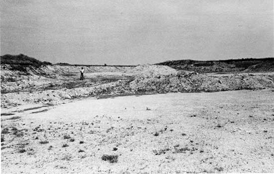
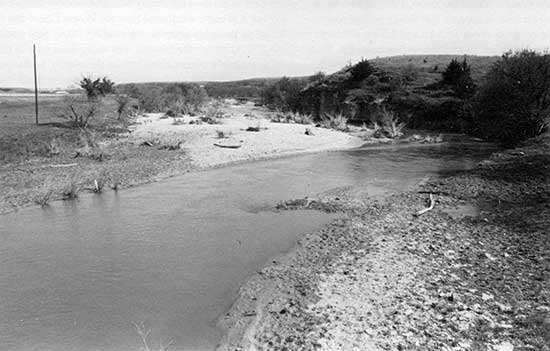
Fluvial deposits--Holocene alluvial deposits are pervasive in stream valleys of Russell County. They are found in two topographic positions: (1) as a major component of the fill beneath a prominent, high terrace (overlying basal late Wisconsin fill) and (2) in bottomlands below the high terrace and in smaller valleys where no high terrace is present. At localities where the Holocene alluvium comprises at least the upper component of the high terrace (fig. 29), it is mapped as Qt on the geologic map of the county. Where younger deposits occur (figs. 29, 30), they are designated Qal (Johnson and Arbogast, 1996).
Figure 29--Holocene alluvium in the Saline River valley in the NE sec. 33, T. 12 S., R. 14 W. The arrow left of center in the photograph points to a cutbank exposing fill beneath the high terrace (mapped as Qt on the geologic map) that extends to the left. In the middle ground, the arrow points to late Holocene alluvium (Qal on geologic map) adjacent to the stream channel.
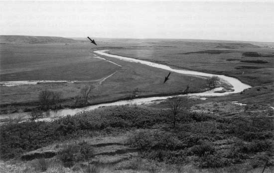
Figure 30--Channel way, floodplain, and low terraces of the Smoky Hill River in the NW sec. 18, T. 12 S., R. 14 W. Bedrock exposed in the valley wall to the right is the Dakota Formation.
Although much research (e.g., Mandel, 1988; Mandel et al., 1991; Johnson and Martin, 1987; Johnson and Logan, 1990; Martin, 1992) concerning the absolute age of Holocene alluvial deposits has been conducted in the Kansas River basin, of which streams in this study are a part, detailed information concerning the chronology of fluvial events during the last 10,000 years in Russell County has only recently emerged. A study associated with an archeological investigation was conducted by May (1986) along the Saline River in the vicinity of Wilson Reservoir. May recognized three terraces, at 16 m (52 ft), 8 m (26 ft), and 3 m (10 ft) above the former channel in the upper end of the reservoir, with multiple alluvial fills being recognized in the two lower terraces. A radiocarbon age of 5,090 ± 60 yr B.P. (Beta-14135) was obtained on a buried soil in one fill, whereas in a younger fill a buried soil yielded an age of 1,940 ± 70 yr B.P. (Beta-14136). In a study of Hebrer's salt marsh upstream of Wilson Lake, floodplain alluviation and paludifacation began about 10 ka as indicated by a basal radiocarbon age of 9,280 ± 210 yr B.P. (Tx-6111) (Norman, 1990).
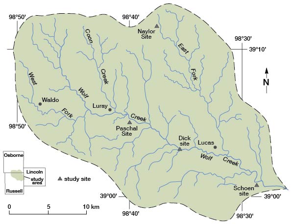
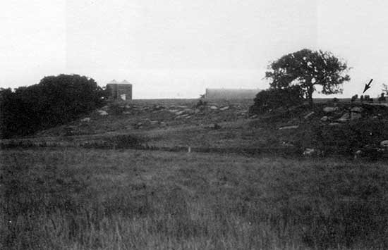
The most detailed reconstruction of Holocene fluvial behavior in Russell County was conducted in Wolf Creek basin (Arbogast, 1992; Arbogast and Johnson, 1994). Located primarily in northeastern Russell County, but including parts of southeastern Osborne County and northwestern Lincoln County (fig. 31), Wolf Creek basin has an area of approximately 163 km2 (100 mi2). Major tributaries of Wolf Creek include East Fork Wolf Creek, Coon Creek, and West Fork Wolf Creek.
Figure 31--Wolf Creek basin with towns, major tributaries, and location of study sites.
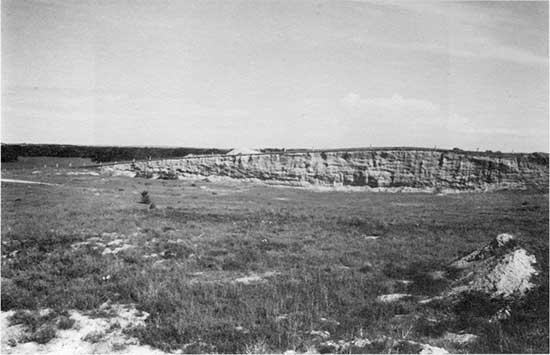
Results obtained from Wolf Creek basin serve as a proxy for the late Quaternary alluvial chronology in the larger stream valleys of Russell County. Four terraces and valley fills were identified in Wolf Creek basin (fig. 32). The uppermost terrace, T-4, is an unpaired fill-top terrace that varies in height from 27 to 18 m (88 to 59 ft) above the floodplain. Best observed at the Schoen gravel quarry in the SE sec. 18, T. 12 S., R. 10 W. (fig. 33), Lincoln County, this terrace is underlain by gravel fill (Fill I) that contains lenses of coarse silt up to 1 m (3.2 ft) thick and is mapped by Johnson and Arbogast (1996) as Qg. As noted earlier, the absolute age of upland gravel deposits in Russell County is unknown.
Figure 32--Generalized stratigraphic cross section of Wolf Creek basin illustrating the relationship of the terraces (T) and floodplain with the alluvial fills in the basin.
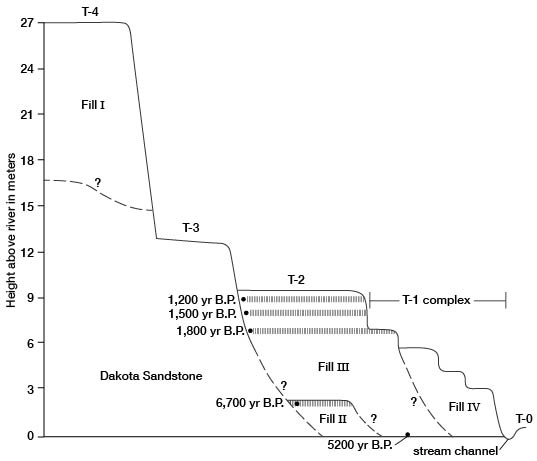
Figure 33--View of the T-4 terrace, underlain by Fill I, at the Schoen gravel pit in the SE sec. 18, T. 12 S., R. 10 W., Lincoln County. Fill I consists of Pleistocene gravel (mapped as Qg on the geologic map) that contains lenses of coarse silt.
The T-3 terrace is an unpaired strath terrace, cut on the Dakota Formation 5-6 m (16-20 ft) above the modern floodplain; it is best preserved at the Dick site in the SE sec. 25, T. 11 S., R. 12 W. (fig. 34). Mapped by Johnson and Arbogast (1996) as Kd because of the underlying Dakota Formation, the T-3 was probably created during the time when entrenchment elevated the T-4.
Figure 34--View of the T-3 terrace at the Dick site in the SE sec. 25, T. 11 S., R. 12 W. During intensive valley entrenchment, a strath terrace was cut on the Dakota Formation (arrow) along the valley margins of Wolf Creek.
The pervasive alluvial surface in Wolf Creek basin is the T-2, a paired fill-top terrace occupying approximately 95% of the valley floor. Mapped as Qt on the geologic map of the county (Johnson and Arbogast, 1996), this terrace extends 3-5 m (10-16 ft) above the modern floodplain and is underlain by silty early and late Holocene fills (Fills II and III, respectively). Both Fills II and III are exposed in the upper reaches of the basin and were analyzed in detail at the Naylor site (fig. 31). In the trunk valley of Wolf Creek and the lower reaches of the major tributaries, only Fill III is exposed; samples were analyzed from the Paschal and Schoen sites (fig. 31) for radiocarbon age determination and for textural and chemical analyses.
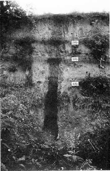
The Naylor site is a 5.5-m (l8-ft)-high cutbank exposure beneath the T-2 in the upper reaches of the East Fork Wolf Creek in the NW sec. 20, T. 10 S., R. 11 W., Osborne County (fig. 35). An unconformity separates Fills II and III, and three buried soils are present, one in Fill II and two in Fill III. Sediments separating the buried soils consist of well-laminated and poorly sorted coarse silt and fine sand. Each of the buried soils recognized at the site are Entisols, consisting of A-AC-C horizon sequences. A radiocarbon age of 6,770 ± 100 yr B.P. (Tx-6914) was obtained from the soil exposed in Fill II. The oldest of the two buried soils in Fill III, which is slightly truncated, yielded an age of 1,880 ± 60 yr B.P. (Tx-6962) whereas an age of 1,460 ± 60 yr B.P. (Tx-6961) was obtained from the uppermost, buried late Holocene soil.
Figure 35--View of the Naylor site in the NW sec. 20, T. 10 S., R. 11 W., Osborne County, that shows the East Fork Wolf Creek, the T-2 terrace, and 5.5 m of alluvial fill. The fill is generally silt and silt loam in texture, poorly sorted, and well laminated. At the base of the exposure is nearly 1.5 m (4.9 ft) of early Holocene fill (Fill II), buried by 4.0 m (13.1 ft) of late Holocene alluvium (Fill III). Radiocarbon dating of the upper 5 cm (2 in) of the 4Ab, 3Ab, and 2Ab horizons yielded ages of 6,770 ± 110 (Tx-6914), 1,880 ± 60 (Tx-6962), and 1,460 ± 60 (Tx-7076) yr B.P., respectively.
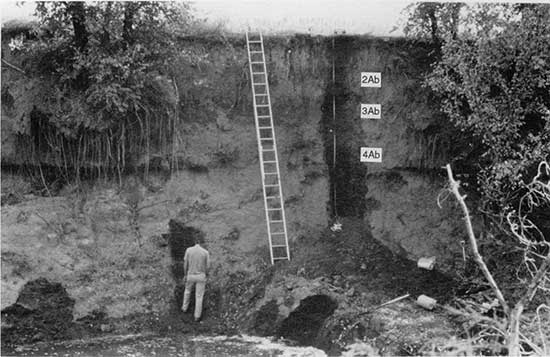
Fill underlying the T-2 terrace was sampled in the upper reaches of the trunk valley of Wolf Creek at the Paschal site, a 9.5-m (3l-ft)-high section of late Holocene silt and silt loam deposits located in the SW sec. 8, T. 11 S., R. 12 W., Russell County (fig. 36). At the base of the exposure, between 9.51 m and 7.93 m (31 ft and 26 ft) below the surface, is a sequence of gravel lenses separated by layers of organic-rich silt, the thickest of which produced an age of 5,350 ± 110 yr B.P. (Tx-7078). Three buried soils, each consisting of A-AC-C horizons (Entisol), are also contained within Fill III at this locality. As at the Naylor site, the deposits separating the buried soils at the Paschal site are well laminated and poorly sorted. Radiocarbon ages of 1,830 ± 70 (Tx-7077), 1,510 ± 80 (Tx-7076), and 1,290 ± 70 yr B.P. (Tx-7075) were obtained from the lower, middle, and upper buried soils, respectively. A charcoal age of 2,060 ± 160 yr B.P. (Beta-2162), which correlates well with the age of the lowermost soil, was obtained from sediments just beneath the lowest buried soil in a cutbank exposure 2.5 km (1.5 mi) upstream (Johnson and Martin, 1987).
Figure 36--View of the Paschal site in the SW sec. 8, T. 11 S., R. 12 W., showing the T-2 terrace and about 9.5 m (31.2 ft) of late Holocene fill (Fill III). The fill at this locality consists of three sedimentary units, largely silt and silt loam in texture, that are poorly sorted and well laminated. At the base of the exposure are alternating layers of coarse gravel and silt. Radiocarbon-age determination on an organic-rich silt layer 8.6 m (28.2 ft) below the surface (arrow) yielded an age of 5,350 ± 110 (Tx-7078). Radiocarbon ages of 1,830 ± 70 (Tx-7077), 1,510 ± 80 (Tx-7076), and 1,290 ± 70 (Tx-7075) yr B.P. were obtained on the upper 5 cm (2 in) of the 4Ab, 3Ab, and 2Ab horizons, respectively.
Close-interval sampling of T-2 fill in the lower reaches of the trunk valley of Wolf Creek was conducted at the Schoen cutbank site, located in the NW sec. 17, T. 12 S., R. 10 w., Lincoln County (fig. 37). At this locality, about 6.5 m (21 ft) of late Holocene fill is exposed beneath the T-2. Detailed analyses of Fill III indicate a stratigraphy and texture similar to that of the Paschal site, i.e., deposits of silt and silt loam that are separated by laminated, medium to fine sands and silt. A deposit of organic-rich silt at the base of the Schoen site yielded an age of 2,970 ± 80 yr B.P. (Tx-6795). Three buried soils, each an Entisol with A-AC-C horizons, were recognized at the Schoen site. Ages of 1,750 ± 70 (Tx-6959) and 1,250 ± 60 yr B.P. (Tx-6960) were obtained on the lowermost and uppermost buried soil, respectively. Although the intermediate soil was not dated, its stratigraphic position and morphologic similarity to the intermediate buried soil dated at the Paschal site indicate an age of about 1,500 yr B.P.
Figure 37--The Schoen site in the NW sec. 17, T. 12 S., R. 10 W., Lincoln County, with WolfCreek, the T-2 terrace and approximately 6.5 m (21.3 ft) of alluvial fill. The fill at this locality is late Holocene in age and is composed of three sedimentary units that are poorly sorted and well laminated. Radiocarbon-age determinations on the upper 5 cm (2 in) of an organic-rich silt layer at the base of the exposure and the 4Ab and 2Ab horizons yielded ages of 2,970 ± 80 (Tx-6795), 1,750 ± 70 (Tx-6959), and 1,250 ± 60 (Tx-6960) yr B.P., respectively.
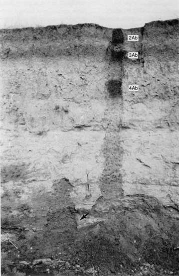
The youngest alluvial landforms in Wolf Creek basin are found in the T-1 complex, consisting of four ill-defined surfaces, and the modern floodplain (T-0). These surfaces are less than 1,000 years old and formed as the channels of Wolf Creek basin became entrenched in conjunction with limited lateral migration. Similar entrenchment has been widely recognized (e.g., Johnson and Martin, 1987; May, 1989; Hall, 1990; Martin, 1992) in stream systems throughout the central Great Plains. Figure 38 illustrates the relationship of the T-1 complex with the T-2 at the Paschal site in plan view. A north-south transect at the Paschal site illustrates morphostratigraphic relationships of the main valley (fig. 39). The uppermost terrace in the T-1 complex is a fill-strath terrace cut on the 4Ab horizon in Fill III alluvium. The remaining surfaces of the T-1 complex and T-0 are fill-top terraces on Fill IV, which consists of 3.5-5 m (11-16 ft) of gravel and silt, mapped as Qal by Johnson and Arbogast (1996). The modern floodplain, or T-0, is poorly developed in Wolf Creek basin, consisting of isolated, narrow surfaces adjacent to the present stream channel where Fill IV is a thin veneer of silt and fine sand overlying coarse gravel.
Figure 38--Aerial photograph of the T-2 terrace (mapped as Qt on the geologic map) and T-1 terrace complex (mapped as Qal) near the Paschal site in sec. 8, T. 11 S., R. 12 W. In this reach of the stream, approximately 25 percent of T-2 fill has been removed by lateral erosion in conjunction with late Holocene stream entrenchment, leaving isolated fragments of the T-2 terrace.
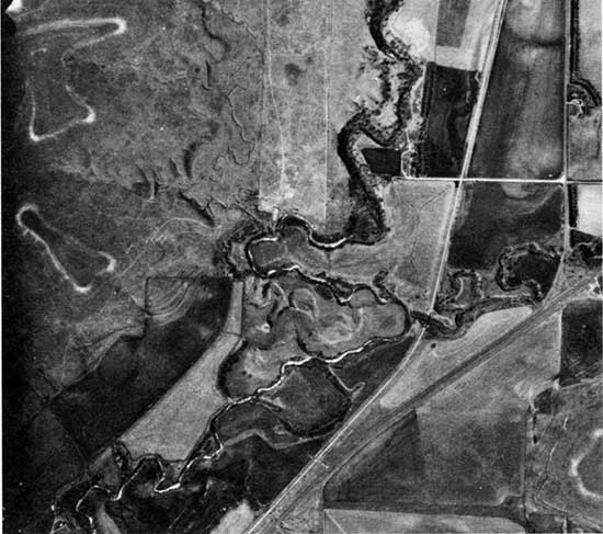
Figure 39--Cross section of T-2 (mapped as Qt on the geologic map). T-1 complex, and T-0 (floodplain) (T-1 and T-0 mapped as Qal) at the Paschal site in SW sec. 8, T. 11 S., R. 12 W. The T-2 terrace is underlain by Fill III. The T-1 terrace complex consists of at least four ill-defined surfaces created by stream-entrenchment and lateral channel migration in the last 1,000 years. The uppermost surface in the T-1 terrace complex is a cut-terrace on Fill III alluvium. while the remaining surfaces are fill-terraces underlain by Fill IV alluvium that caps Fill III.
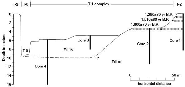
Prev Page--Introduction || Next Page--Recent Geologic History
Kansas Geological Survey, Geology
Placed on web April 8, 2013; originally published 1996.
Comments to webadmin@kgs.ku.edu
The URL for this page is http://www.kgs.ku.edu/Publications/Bulletins/TS7/03_strat.html