Kansas Geological Survey, Technical Series 2
Prev--Water Resources
Alluvial environment: In general, a nonmarine environment dominated by the geologic processes associated with rivers and streams.
Aquifer: A part of a geologic formation (or one or more geologic formations) that is porous and permeable enough to transmit water at a rate sufficient to feed a spring or for economic extraction by a well. An aquifer transmits more water than an aquitard.
Aquitard (Confining unit): A part of a geologic formation (or one or more geologic formations) of much lower permeability than an aquifer (generally two or more orders of magnitude less) that will not transmit water at a rate sufficient to feed a spring or for economic extraction by a well.
Artesian pressure: The fluid pressure of the water in a confined aquifer indicated by the height of water above the top of the overlying aquitard in wells.
Boundary conditions: A mathematical expression of a state of a physical system that constrains the equations of a mathematical model of the system.
Capture: Water withdrawn artificially from an aquifer is derived from a decrease in storage in the aquifer, a reduction in the previous discharge from the aquifer, and increase in recharge, or a combination of these changes. The decrease in discharge plus the increase in recharge is termed capture. Capture generally results in reduced surface flows.
Cation exchange: The uptake of cations from solution by and the subsequent release of bound cations from the aquifer framework. This commonly occurs in fine-grained sediments containing clays. The individual clay particles often contain loosely bound ions (such as sodium) in their crystal lattice and adsorbed on the surface to reduce an overall charge imbalance. When ground water containing calcium ions passes through a clayey, porous medium containing adsorbed sodium ions, the clays preferentially replace the sodium for the calcium ions and release sodium to the ground water.
Cenozoic Era: The interval of geologic time that extends from approximately 66.4 million years ago up to the present.
Cone of depression: A cone-shaped lowering of the water table (or potentiometric surface) around a pumping well due to the temporary reduction in hydraulic head due to pumping.
Confined aquifer: An aquifer that is bounded above and below by aquitard units; water levels in wells screened in the confined aquifer are higher than the top of the aquifer.
Consolidation: In soil mechanics, the gradual reduction in volume and increase in density of unconsolidated sediments in response to loading or a compressive stress.
Cretaceous (Series): Rocks that were deposited during the interval between 144 and 66.4 million years ago.
Deltaic environment: In general, a nonmarine to marine environment dominated by the geologic processes associated with deltas.
Diffusivity: The ratio of the hydraulic conductivity to the specific storage of an aquifer. Diffusivity is a measure of the sensitivity of the aquifer to changes in hydraulic head. The higher the diffusivity, the more quickly changes in hydraulic head due to pumping will propagate through the aquifer to either the recharge or the discharge area or both.
Discharge area: An area where ground water is lost naturally from an aquifer through springs, seeps, or hydraulic connection to other aquifers.
Distributary channel: One of the many divergent stream or river channels carrying water and sediment across a delta to a sea or lake.
Drawdown: The lowering of hydraulic head in an aquifer that results from pumping.
Equipotential: A line of equal hydraulic head drawn on a map or on a vertical cross section. The direction of ground-water flow is generally taken to be perpendicular to the equipotential and opposite to the direction of the hydraulic gradient.
Era: A unit of geologic time next in order of magnitude below an eon and containing two or more periods.
Fluvial: Of or pertaining to a river or stream. Formation water: The ground water contained within a porous medium, which may be fresh or saline.
Gamma-ray log: A record of the natural radioactivity emanating from the rocks with depth along the wall of a borehole.
Ground water: Subsurface water beneath the top of the zone of saturation or the water table. Ground water flows naturally from areas of recharge to areas of discharge.
Ground-water basin: A geologically and hydrologically defined region bounded by regional surface or ground-water divides or both.
Ground-water-flow system: The subsurface part of the hydrologic cycle that includes areas of recharge and discharge and the paths traveled by ground water in between these areas within a ground-water basin. The ground-water-flow system includes the flows across all aquifer and aquitard units below the top of the zone of saturation. Flow systems are dependent on both the arrangement and properties of aquifer and aquitard units and the nature of the topography within the basin. Areas of gently sloping topography with low local relief tend to be dominated by regional flow systems. Discharge areas in regional flow systems are often hundreds of miles away from areas of recharge. Areas of steep or undulating (hummocky) topography tend to be dominated by local flow systems. Local flow systems are much smaller in scale (on the order of 10 mi [16 km] or less) and may only involve a single aquifer.
Ground-water storage: 1) The quantity of water in the saturated zone, or 2) water available to wells from the aquifer, excluding capture.
Heterogeneity: A property that varies with location in the porous medium.
Hydraulic conductivity: A property that depends on the intrinsic permeability of the porous medium and the viscosity and density of the invading fluid.
Hydraulic head: The height that water in an aquifer can raise itself above an arbitrary reference level or datum (commonly mean sea level) measured in feet. When a borehole is drilled, the elevation of the water level in the borehole is for all practical purposes the hydraulic head of the aquifer at that point. The hydraulic head defines how much potential energy is possessed by the water at a point in the ground-water-flow system. Ground water possesses energy by virtue of its position (elevation head) and its pressure (pressure head). In a ground-water-flow system, the movement of water is accompanied by a reduction in hydraulic head.
Hydraulic-head gradient: The change in hydraulic head per unit distance in a specific direction indicated by the slope of the water table or the potentiometric surface. The maximum hydraulic gradient is opposite to the direction of ground-water flow.
Hydraulically connected: A condition where two or more adjacent aquifers are in physical contact so that there are no intervening aquitard units to restrict the flow of ground water between them. As a result, a change in hydraulic head in one aquifer where they are hydraulically connected is readily transmitted to the other aquifers.
Hydrogeology: The study of ground water with particular emphasis given to its chemistry, the influences on its flow, and its relationship to the geologic environment.
Hydrograph: A graph showing the fluctuations in water level or hydraulic head in a well over time.
Hydrostratigraphic unit: Portions of a geologic unit or one or more adjacent geologic units distinguished by their porosity and permeability (hydraulic-conductivity) characteristics.
Impairment: In a hydrogeologic sense, the reduction in flow to a well that occurs when its cone of depression overlaps with the cone of depression of a nearby well. In the area of overlap, the drawdown from simultaneously pumping both wells is the sum of the drawdowns that would occur if each well were being pumped singly.
Intrinsic permeability: A quantitative measure of the fluid-transmitting ability of the porous medium that is related to the size and interconnectedness of its void spaces. For a granular porous medium, this property depends on the grain-size distribution.
Jurassic (Series): Rocks that were deposited during the interval between 208 and 144 million years ago.
Laramide Orogeny: An episode of regional uplift resulting in the formation of the Rocky Mountains that began near the end of the Cretaceous Period and extended into the Tertiary Period.
Lithology: The description of rocks or sediments on the basis of such characteristics as color, structure, mineralogic composition, and grain size.
Major constituent: Dissolved ionic constituents usually present in amounts greater than a few mg/L, including calcium, magnesium, sodium, bicarbonate, sulfate, and chloride.
Mesozoic Era: The geologic time interval between the Cenozoic and Paleozoic Eras from 245 to 66.4 million years ago.
Minor constituent: Dissolved ionic constituents usually present in amounts greater than 0.1 mg/L and less than 10 mg/L. This usually includes potassium, nitrate, iron, fluoride, strontium, and boron.
Mudcake: During drilling, a layer of cuttings and drilling mud that builds up on the wall of the borehole uphole from the drill bit.
Mud filtrate: The invading fluid that flows outward from the borehole during drilling and into the surrounding porous medium. The depth of invasion depends on the porosity and permeability of the host rock as well as the amount of time available during invasion.
Mudstone: A general term that includes claystone, siltstone, and shale.
Multi-story: A vertical sequence of channel sandstone bodies that often appear as locally amalgamated bodies of sandstone where cut and fill has removed intervening fine-grained floodplain deposits.
Nearshore environment: In general the region where marine processes dominate seaward of the shoreface and shoreward of the open marine environment.
Outcrop/subcrop belt: A belt where the combined Dakota Formation, Kiowa Formation, and Cheyenne Sandstone crop out at the surface or beneath younger Cenozoic deposits near their eastern and southern extents in Kansas. The younger Cretaceous units all have been removed by erosion within this belt.
Quaternary (Series): Strata deposited during the Quaternary Period from 1.59 million years up to approximately 10,000 years ago.
Paleoshoreline: An ancient shoreline whose location has been inferred from its associated deposits.
Paleovalleys: An ancient buried valley whose location has been inferred from its associated deposits.
Paleozoic Era: The interval of geologic time that extends from approximately 570 to 245 million years ago.
Pennsylvanian (Series): Rocks that were deposited during the interval between 320 and 286 million years ago.
Permian (Series): Rocks that were deposited during the interval between 286 and 245 million years ago.
Porosity: A quantitative measure of the void space in relation to the bulk volume of a porous medium.
Potentiometric surface map: A contoured map showing the variation in hydraulic head within an aquifer. The contours drawn on the map are lines of equal hydraulic head, or equipotentials. Hydrogeologists use these maps to discern the flows of ground water between recharge and discharge areas and for other purposes.
Recharge area: A geographic area where water enters a ground-water flow system or an aquifer. Recharge areas usually coincide with topographically elevated regions where aquifer units crop out at the surface. In these areas, infiltrated precipitation is the primary source of recharge. The recharge area may also coincide with the area of hydraulic connection where one aquifer receives flow from another adjacent aquifer.
Rock stratigraphic unit: A mappable geologic unit distinguished by its lithologic characteristics and relative lithologic homogeneity.
Shoreline environment: In general, an environment dominated by the geologic processes associated with a shoreline, including supratidal, tidal, and subtidal environments.
Series: All of the rocks that were deposited during a specific interval of geologic time, such as the Permian or Cretaceous Periods.
Specific conductance: A measure of the ability of water to conduct an electrical current, expressed in microsiemens or micromhos per centimeter (µs/mn or µmho/cm) at 25° C. Specific conductance is related to the type and concentration of ions in solution and can be used for approximating the dissolved solids content of the water. Commonly, the concentration of dissolved solids (in milligrams per liter) is about 65% of the specific conductance (in micromhos per centimeter). This relation is not constant from supply to supply, and it may even vary in the same source with changes in composition of the dissolved-solids load in the water.
Specific storage: The volume of water released from or taken into storage per unit volume of the confined aquifer per unit change in hydraulic head.
Steady state: A ground-water-flow system condition in which recharge is balanced by discharge from the system and there is no change in the amount of water in storage with time.
Storativity: The volume of water released from storage per unit area of confined aquifer and per unit drop in hydraulic head. The storativity is a function of the compressive qualities of the aquifer framework and the water in the aquifer.
Surface casing: An outer well casing installed to protect fresh ground water from contamination by saltwater moving upward from deeper aquifers along the annular space of the borehole.
Sustainability: The ability of the aquifer to supply water to users without being depleted during the planning period.
Tectonic activity: Processes involving crustal movements, resulting in episodes of subsidence and uplift.
Total dissolved solids concentration: The concentration of all of the dissolved ionic constituents in water, usually expressed in milligrams per liter (mg/L).
Trace constituent: Dissolved ionic constituents usually present in amounts less than 0.5 mg/L.
Transient: In ground water, a state of the flow system in which the hydraulic head changes with time.
Transmissivity: A quantitative measure of the capacity of an aquifer to transmit flow through a given cross sectional area, expressed as volume per unit time per unit surface area. Transmissivity is the product of the aquifer hydraulic conductivity and thickness.
Unconfined (water-table) aquifer: An aquifer bounded above by the water table.
Unconsolidated: Loosely arranged, uncemented.
Water budget: A method of tracking the flows of water through all or parts of the subsurface hydrologic cycle in a particular geographic area, including recharge, storage within the aquifer or the flow system, and discharge. Discharge includes natural discharge, ground-water withdrawals, evapotranspiration losses, and flows to streams or other hydraulically connected aquifers. Recharge includes infiltrated precipitation that enters the flow system in recharge areas and flows from other aquifers.
Water quality: The physical, chemical, and biological characteristics of water and how they relate to particular uses.
Water table: The approximate upper boundary of the ground-water-flow system.
Well-head protection: A means of protecting the groundwater supply of a well field from contamination due to human activity. To initiate well-head-protection efforts, potential contamination sources must be identified, and the ground-water-flow patterns and time of travel of dissolved contaminants from a point of introduction to the well field must be delineated. Zoning and other land-use controls are typically used to eliminate sources of contamination and protect the ground-water supply.
Western Interior seaway: An asymmetrical basin that extended from the Gulf Coast to the Arctic Circle in North America during the Cretaceous Period.
Is the Dakota aquifer present in a specific area? Are the quality and quantity of the water suitable for your particular water use? How expensive will it be to utilize the Dakota? These are questions that can be addressed by incurring only the expenses from a few phone calls, some postage, and publications such as this user's guide. An initial evaluation of the Dakota aquifer can answer these questions. Several sources of information are available to anyone interested in investigating or utilizing groundwater resources, either for irrigation or personal use. Often, the best source of information is local people who are familiar with well drilling or local ground-water resources. This is usually a good place to start because they may know local areas better than the State agencies that have to cover the entire state. If local water-resource people cannot answer specific questions, they often know who to contact. Several State and Federal water-related agencies also offer assistance and information to anyone interested in the Dakota aquifer as a source of water. The following is a summary of the functions of and information available from the various Federal, State, and local agencies.
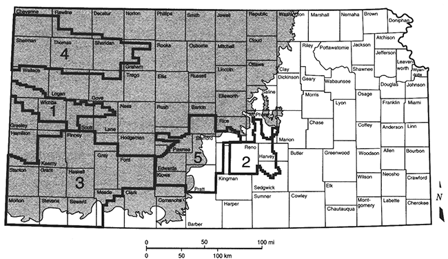
Groundwater Management Districts. Some areas of Kansas are represented at the local level by groundwater management districts (GMDs), entities governed by local boards who are authorized under State law to manage water resources in their districts. The four GMDs that are underlain by the Dakota aquifer are outlined in fig. A2.1.
Figure A.2.1--Groundwater Management Districts underlain by the Dakota aquifer in Kansas.
County Health Departments. County Health Departments are concerned with drinking-water quality. Usually for a nominal fee, they will provide sample bottles and instructions for individuals to take their own samples. You will need to send the sample to the Kansas Department of Health and Environment for analysis at nominal cost. The analysis examines concentrations of basic bacteriological and chemical components for safe drinking water.
Cooperative Extension Service. Kansas State University's Cooperative Extension Service has offices in every county in Kansas. County extension agents can provide information and educational programs in water quality and soil and water conservation. Educational efforts involve irrigation and water-use efficiency; natural resource, energy, and environmental stewardship; non-point pollution prevention and abatement; and safe use of chemicals. County agents and specialists work with farmers, irrigators, and groundwater management, watershed, and conservation districts to manage and conserve the state's soil and water resources.
Water-well Drillers. Water-well drillers are another source of local information. A list of local drillers can be found in telephone directories. Water-well drillers usually have several years of practical experience in local areas and can often provide general information about drilling a well at a specific site. They sometimes have records of other wells drilled in the area. More information on water-well drillers and drilling techniques can be obtained by contacting the Kansas Ground Water Association directly.
The Kansas Geological Survey (KGS) conducts geological studies and research and maintains information about water quality and quantity and other earth resources in Kansas. Available from the Survey are water-well records, maps, publications, and other water-related information. Additional information on the Dakota aquifer can be found on the Kansas Geological Survey (KGS) home page on the World Wide Web at http://www.kgs.ku.edu/.
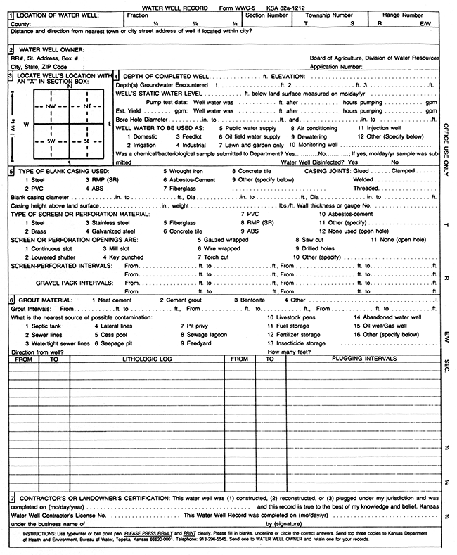
Water-well Records. Commonly referred to as the "WWC-5" records, this form is required by the State of anyone drilling a water well. Examining these records for wells drilled in the area of interest can provide information on drilling depths, flow rates, and water quality. The WWC-5 form includes information on location of the water well; the well owner; depth of the well, depth to water, and the estimated yield; casing, perforation, and completion information; and a lithologic log. Figure A2.2 is a reproduction of a Water Well Record (form WWC-5). The Water-well Records are maintained by the Geoscience Data Library at the KGS.
Figure A.2.2--Reproduction of a water well record (form WWC-5).
Electric Logs. Many wells have been drilled through the Dakota aquifer in search of oil and gas. Electric and radioactivity logs were run on most wells, and these records are available at the Survey. In addition, the Survey has other oil and gas well-drilling information that may be useful for Dakota aquifer evaluation or exploration.
Kansas Water Levels. Water-level measurements in Kansas are reported each year and compared to long-term water-level changes. Information on well locations and characteristics, past and present water-level measurements, water resources, and trends in the measurements are presented in this annual KGS publication. Copies of this report can be obtained from Publications Sales at the KGS. Water-level data also can be obtained on the KGS World Wide Web pages.
Publications and Maps. The KGS has numerous publications and maps that may be useful in ground-water exploration. Topographic (with contours) and planimetric (without contours) maps are available for the entire state at scales ranging from the detailed 1:24,000-scale series (7.5-minute quadrangle) to generalized 1:500,OOO-scale maps of the state. Technical and non-technical publications related to ground-water occurrence, chemical quality, irrigation, and many other topics are available at the KGS. Contact Publications Sales at 785/864-3965.
Numerous State and Federal agencies have regulatory and non-regulatory responsibilities involving Kansas water. Listed below are some of the principal agencies that could be helpful in exploring for water in the Dakota aquifer.
Division of Water Resources
Kansas Department of Agriculture
1320 Research Park Drive
Manhattan, Kansas 66502-5000
785/564-6640
The Division of Water Resources (DWR) is the primary State agency regulating the appropriation of surface and ground water for beneficial use in Kansas. Through the Groundwater Management District Act of 1972, the DWR works with local groundwater management districts in the management of ground-water resources within each district's boundaries. The DWR is involved in intensive ground-water use control areas (IGUCA)-areas experiencing unusual declines or areas that require special management considerations. The DWR also measures water levels in many wells as part of the State water-level program.
Kansas Corporation Commission
Oil and Gas Conservation Division
266 N. Main St., Suite 220
Wichita, Kansas 67202-1513
316/337-6200
The Oil and Gas Conservation Division of the Kansas Corporation Commission (KCC) has regulatory responsibility for permitting the location and construction (including surface-casing requirements) of oil and gas wells in Kansas and for the proper plugging or temporary abandonment of these wells. The Division's mandate is to protect fresh and usable water resources. The Division also has responsibility for implementing the Underground Injection Control program for Class II (oil and gas) wells in Kansas. States are required to meet EPA standards for regulating underground injection of fluids. Injection applications are technically reviewed by the Division to ensure that fresh and usable water, hydrocarbons, and correlative rights will be protected.
Kansas Department of Health and Environment
Division of Environment
1000 SW Jackson, Suite 430
Topeka, Kansas 66612-1367
785/296-1535
The Division of Environment in the Kansas Department of Health and Environment (KDHE) is responsible for identifying water-quality and water-pollution problems and recommending appropriate remediation. The Division also regulates coal mining and reclamation, non-point source pollution, hazardous-waste facilities, livestock feedlots, wastewater-treatment facilities, public-water supplies, and solid-waste landfills. Since 1975 the Division has been responsible for managing water-well records submitted to the agency by drillers (WWC-5 form) and has maintained a State licensing program for water-well drillers. The Division is a source of information concerning water quality, water wells drilled and plugged in the state since 1975, and regulations on well construction.
Kansas Water Office
900 SW Jackson, Suite 404
Topeka, Kansas 66612
785/296-3185
The Kansas Water Office formulates, on a continuous basis, a comprehensive Kansas Water Plan for the management, conservation, and development of the water resources of the state. The Water Plan provides for the establishment of basin advisory committees - groups of citizen volunteers in each river basin - that provide advice on the formulation and implementation of the Kansas Water Plan. The Water Office oversees the State's water-marketing and water-assurance programs, monitors water research by governmental agencies, develops water-supply and demand estimates for Kansas, issues licenses and permits for weather-modification activities, and establishes and monitors minimum desirable streamflows.
Environmental Protection Agency
11201 Renner Blvd.
Lenexa, Kansas 66219
913/551-7003
The Region VII office in Kansas City is responsible for Federal environmental regulations in Kansas and provides support for the State ground-water program, wastewater-treatment facilities, and other pollution-control activities through grants and loans. The EPA oversees the Safe Drinking Water Act, has a wellhead-protection program for wells that produce drinking water, regulates permits for pollution discharges, administers a non-point source pollution-control program (with KDHE), sets water-quality standards for state surface waters, and is responsible for underground injection control (with KDHE and KCC).
U.S. Geological Survey, Water Resources Division
4821 Quail Crest Place
Lawrence, Kansas 66049
785/842-9909
In Kansas, this Federal agency conducts regional hydrologic studies, undertakes research in geochemistry, and conducts studies in water quality in Kansas and adjacent states. This agency also has developed and maintains a statewide network for collecting water-resource data. Numerous publications and maps on ground water are available from the U.S. Geological Survey.
Local Soil and Water Conservation District Offices
Natural Resources Conservation Service (NCRS)
U.S. Department of Agriculture
Formerly the Soil Conservation Service, the NRCS provides technical assistance to farmers and ranchers to develop and apply soil- and water-conservation plans for their land. Assistance is provided through the state's 105 local conservation districts.
Belitz, K., and Bredehoeft, J. D., 1988, Hydrodynamics of the Denver basin-Explanation of fluid subnormal pressures: American Association of Petroleum Geologists, Bulletin 72, no. 11, p. 1,334-1,359
Boeken, R., 1995, Estimate of water quality in the Dakota aquifer of northwest Kansas using self potential readings of downhole geophysical logs: Kansas Geological Survey, Open-file Report 95-1a, 93 p. [available online]
Darton, N. H., 1905, Preliminary report on the geology and underground water resources of the central Great Plains: U.S. Geological Survey, Professional Paper 32, 433 p. [available online]
Franks, P. C., 1979, Paralic to fluvial record of an Early Cretaceous marine transgression--Longford Member, Kiowa Formation, north-central Kansas: Kansas Geological Survey, Bulletin 219, 55 p. [available online]
Hamilton, V. J., 1994, Sequence stratigraphy of Cretaceous Albian and Cenomanian strata in Kansas; in, Perspectives on the Eastern Margin of the Cretaceous Western Interior Basin, G. W. Shurr, G. A. Ludvigsen, and R H. Hammond, eds.: Geological Society of America, Special Paper 287, p. 79-96
Hattin, D. E., and Siemers, C. T., 1987, Guidebook--Upper Cretaceous stratigraphy and depositional environments of western Kansas (with modifications): Kansas Geological Survey, Guidebook Series 3, 55 p. [available online]
Helgesen, J. O., Leonard, R. B., and Wolf, R J., 1993, Aquifer systems underlying Kansas, Nebraska, and parts of Arkansas, Colorado, Missouri, New Mexico, Oklahoma, South Dakota, Texas, and Wyoming--Hydrology of the Great Plains aquifer system in Nebraska, Colorado, Kansas, and adjacent areas: U.S. Geological Survey, Professional Paper 1414-E, 161 p. [available online]
Keene, K. M., and Bayne, C. K., 1977, Ground water from lower Cretaceous rocks in Kansas: Kansas Geological Survey, Chemical Quality Series 5, 18 p. [available online]
Lobmeyer, D. H., and Weakly, E. C., 1979, Water in the Dakota formation, Hodgeman and Ford counties, southwestern Kansas: Kansas Geological Survey, Irrigation Series 5, 41 p. [available online]
Macfarlane, P. A., 1995, The effect of river valleys and the upper Cretaceous aquitard on regional flow in the Dakota aquifer in the central Great Plains of Kansas and southeastern Colorado; in, Current Research in Earth Sciences: Kansas Geological Survey, Bulletin 238, p. 11-30 [available online]
Macfarlane, P. A., and Sawin, R. S., 1995, A user's guide to well-spacing requirements for the Dakota aquifer in Kansas: Kansas Geological Survey, Public Information Circular 1,4 p. [available online]
Macfarlane, P. A., Combes, J., Turbek, S., and Kirshen, D., 1993, Shallow subsurface bedrock geology and hydrostratigraphy of southwestern Kansas: Kansas Geological Survey, Openfile Report 93-1a, 13 p. and 18 maps [available online]
Macfarlane, P. A., Doveton, J. H., and Coble, G., 1989, Interpretation of lithologies and depositional environments of Cretaceous and Lower Permian rocks using a diverse suite of logs from a borehole in central Kansas: Geology, v. 17, p.303-306
Macfarlane, P. A., Doveton, J. H., Feldman, H. R, Butler, 1. J., Jr., Combes, 1. M., and Collins, D. R., 1994, Aquifer/aquitard units of the Dakota aquifer system in Kansas--Methods of delineation and sedimentary architecture effects on ground-water flow and flow properties: Journal of Sedimentary Research, v. 64, no. 4, p. 464-480
Macfarlane, P. A., Townsend, M. A., Whitemore, D.O., Doveton, J. H., and Staton, M., 1988, Hydrogeology and water chemistry of the Great Plains (Dakota, Kiowa, and Cheyenne) and Cedar Hills aquifers in central Kansas--End of contract report: Kansas Geological Survey, Open-file Report 88-39, 184 p. [available online]
Macfarlane, P. A., Wade, A., Doveton, J. H., and Hamilton, V. J., 1991, Revised stratigraphic interpretation and implications for pre-Graneros paleogeography from test-hole drilling in central Kansas: Kansas Geological Survey, Open-file Report 91-1A, 73 p. [available online]
Macfarlane, P. A., Whittemore, D.O., Chu, T., Butler, J. J., Jr., Wade, A., Coleman, J., Doveton, J. H., Mitchell, J. E., and Kay, S., 1991, The Dakota Aquifer Program--Annual report, FY91: Kansas Geological Survey, Open-file Report 92-1, 93 p. [available online]
Macfarlane, P. A., Whittemore, D.O., Doveton, J. H., Chu, T., Smith, M., Feldman, H., Myers, N. C., and Gillespie, J. B., 1994, The Dakota Aquifer Program--Annual report, FY93: Kansas Geological Survey, Open-file Report 94-1, 115 p. [available online]
Macfarlane, P. A., Whittemore, D.O., Townsend, M. A., Butler, J. J., Jr., Doveton, J. H., Hamilton, V. J., Coleman, J., Chu, T., and Wade, A., 1991, The Dakota Aquifer Program--Annual report, FY90: Kansas Geological Survey, Open-file Report 91-1, 42 p. [available online]
Macfarlane, P. A., Whittemore, D.O., Townsend, M. A., Doveton, J. H., Hamilton, V. J., Coyle, W. G., III, Wade, A., Macpherson, G. L., and Black, R. D., 1990, The Dakota Aquifer Program--Annual report, FY89: Kansas Geological Survey, Open-file Report 90-27, 301 p. [available online]
Wade, A., 1991, Determination of aquifer properties of the Dakota aquifer in Washington County, Kansas, from a pumping test: Kansas Geological Survey, Open-file Report 91-1c, 62 p. [available online]
Watts, K. R., 1989, Potential hydrologic effects of ground-water withdrawals from the Dakota aquifer, southwestern Kansas: U.S. Geological Survey, Water-supply Paper 2304, 47 p. [available online]
Whittemore, D.O., Macfarlane, P. A., Doveton, J. H., Butler, J. J., Jr., Chu, T., Bassler, R, Smith, M., Mitchell, J. E., and Wade, A., 1993, The Dakota Aquifer Program--Annual report, FY92: Kansas Geological Survey, Open-file Report 93-1, 170 p. [available online]
Kansas Geological Survey, Geohydrology Section
Placed on web Aug. 19, 2014; originally published in 1999.
Comments to webadmin@kgs.ku.edu
The URL for this page is http://www.kgs.ku.edu/Publications/Bulletins/TS13/03_appendices.html