Kansas Geological Survey, Chemical Quality Series 5, originally published in 1977
Originally published in 1977 as Kansas Geological Survey Chemical Quality Series 5. This publication is also available as an Acrobat PDF file (1.5 MB); plates linked below.
Continuing declines in the water table in western Kansas due to the heavy demands of irrigation and municipalities have led to a search for additional supplies of water. Lower Cretaceous rocks (primarily the Cheyenne Sandstone and Dakota Formation) have long supplied water for irrigation and stock.
This survey of the available data on the quantity and quality of ground water available from Lower Cretaceous rocks indicates that an estimated 70-80 million acre-feet of fresh water containing less than 1,000 mg/l (milligrams per liter) dissolved solids and 10-15 million acre-feet of slightly saline water containing 1,000-3,000 mg/l dissolved solids could be obtained. The Kansas Department of Health and Environment recommends less than 500 mg/l dissolved solids for drinking water and will accept up to 1,000 mg/l. Thus, much of the available water could be used as is and even more would be available after desalinization. Water quality tends to be good to the south and the east along the Lower Cretaceous outcrop belt and to gradually decline towards the north and west.
The Lower Cretaceous rocks outcrop in a band from the southwest in a northeasterly direction across the center of the State and are present in the subsurface to the north and west. Their depth increases to 2,600 feet below land surface in the extreme northwest. The thickness of sandstone in the Lower Cretaceous rocks is less than 200 feet in most of Kansas, but is as much as 400 feet in Lane County. The movement of water in Lower Cretaceous sandstones is generally in an easterly or northeasterly direction. The rocks are directly overlain and hydraulically connected with Pliocene and Pleistocene aquifers in parts of southwestern Kansas. Although ground water from the Lower Cretaceous rocks has seen only moderate use to date, there are indications that, locally, pumpage already exceeds recharge.
The ground-water resources in the Lower Cretaceous rocks of western Kansas represent a significant resource for present and future. Additional studies are needed of the regional relationships of the Lower Cretaceous aquifers to overlying Pliocene and Pleistocene aquifers and underlying Jurassic and Permian aquifers with respect to head changes and water-quality changes that may result from water-level declines in the overlying aquifers and pumpage from large numbers of multi-aquifer irrigation wells. Careful planning could result in an extended lifetime for the aquifers.
Sandstones in Lower Cretaceous rocks contain supplies of water that may be adequate to meet increasing present and future demands for supplemental municipal and domestic use in central and western Kansas. An estimated 70 to 80 million acre-feet of water containing less than 1,000 milligrams per liter dissolved solids may be acceptable for use at the present (1976). An additional 10 to 15 million acre-feet containing 1,000 to 3,000 milligrams per liter dissolved solids is estimated to be available for use in the future with appropriate desalinization.
Lower Cretaceous rocks crop out from Washington County on the north to Comanche County on the south. The rocks dip from a structural high in the southwest part of the State to structural lows in the northwest and north-central part. Depth below land surface increases generally northwestward to about 2,600 feet; thickness of the rocks increases westward from nearly zero to about 850 feet.
The rocks consist chiefly of marine to nonmarine shale and siltstone interbedded with coastal to deltaic sandstone. The interbedded sandstone, which composes about one-third of the rocks, consists of one or more lenses that thicken westward to about 400 feet in the central part of western Kansas.
The yield of water to individual wells is related to area] extent, thickness, and interconnection of the sand lenses and to grain size and cementation of the sand. Large amounts of water may be pumped by wells where loosely cemented sand lenses are interconnected. Wells commonly yield adequate supplies for domestic and stock use; reported yields from municipal and irrigation wells range from about 100 to 2,000 gallons per minute.
Recharge to the Lower Cretaceous rocks occurs in the area of outcrop and from hydraulically connected saturated Cenozoic rocks, especially in the southern part of the State. Movement of water is principally northeastward from areas of recharge to areas of discharge where streams intersect the sandstone outcrops.
Water in the sandstone aquifers commonly is confined between beds of relatively impermeable shale, causing water in wells to rise above the top of the aquifer. Water levels fluctuate in response to changes in atmospheric pressure, recharge, and discharge; greatest fluctuations result from discharge to wells for municipal and irrigation use. Progressive declines in water levels have occurred where irrigation withdrawals exceed recharge.
Calcium bicarbonate water is dominant near recharge areas; mixed sodium and calcium bicarbonate water and sodium chloride water become successively dominant as the water moves downgradient from the recharge areas. The quality of water ranges from fresh to very saline (less than 1,000 to 35,000 milligrams per liter dissolved solids). In the areas of generally fresh water, localized areas of calcium sulfate water result from solution of gypsum in the Kiowa Formation, and areas of sodium chloride water result from contamination by oil-field brines.
Increasing demands for water in central and western Kansas necessitate an evaluation of supplemental water supplies for this area. Rocks of Early Cretaceous age are the shallowest bedrock aquifers that might contain water supplies of adequate quantity and quality to satisfy the demands. [Note: The classification and nomenclature of stratigraphic units used in this report are those of the Kansas Geological Survey and differ somewhat from those of the U.S. Geological Survey.] A primary purpose of this study is to define the availability and chemical quality of water from Lower Cretaceous rocks and to describe its adequacy for municipal and domestic supplies.
Although the Lower Cretaceous rocks have been described in the areas of outcrop, and in areas where supplemental irrigation water is obtained, this is the first regional investigation of these rocks as an aquifer in Kansas. Water having a concentration of less than 3,000 mg/l (milligrams per liter) dissolved solids (fresh to slightly saline water) and a concentration of less than 500 mg/l chlorides occur in Lower Cretaceous rocks in much of the northern and western part of the study area. With appropriate desalinization, these waters can be used for supplemental water supplies for municipal or industrial purposes.
It is necessary, however, to emphasize that water containing 1,000 to 3,000 mg/l dissolved solids should be appropriately desalinized before it is used for human consumption. "Appropriate desalinization" probably will be done, in parts of the study area of this report, in future years to supply the demand of the population. Existing State regulations require the protection of aquifers containing water having 10,000 mg/l or less dissolved solids so that supplies will be available if the demand for municipal and domestic use becomes sufficiently great.
The objective in the study is to delineate the areas in the State where usable water for future municipal and domestic supplies (upper limit of dissolved-solids contents for usable water is defined as 3,000 mg/l) occurs in the Lower Cretaceous rocks. As the quantity of water obtainable from wells in these rocks depends on the thickness, porosity, and permeability of the sandstones and siltstones, these factors were determined from an evaluation of available data.
The study is a part of a continuing cooperative program of ground-water investigations by the Kansas and U.S. Geological Surveys, with data and support from the Division of Water Resources of the Kansas Department of Agriculture and the Division of Environment of the Kansas Department of Health and Environment.
For readers familiar with or interested in the metric system, English units of measurement given in this report are listed in equivalent metric units, using the following abbreviations and conversion factors:
| English units | Multiply by | Metric unit |
|---|---|---|
| foot (ft) | 0.3048 | meter (m) |
| mile (mi) | 1.609 | kilometer (km) |
| acre | .4047 | square hectometer (hm2) |
| square feet (ft2) | .0929 | square meters (m2) |
| acre-feet (acre-ft) | 1.233 x 10⁻³ | cubic hectometers (hm3) |
| gallons per minute (gpm) | .06309 | liters per second (l/s) |
Lower Cretaceous rocks crop out in a broad band from near northeastern Washington County to central Rice County, as shown in figure 1. From central Rice County to southeastern Kiowa and central Comanche Counties, the rocks generally are buried beneath Cenozoic deposits. In the area west of Comanche County, Lower Cretaceous rocks commonly are buried by Cenozoic deposits, except for scattered outcrops in Clark, Ford, Grant, Kearny, Hamilton, and Stanton counties.
Figure 1--Location and extent of Lower Cretaceous rocks.
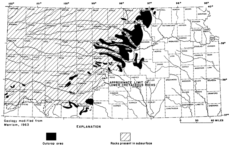
In north-central Kansas the width of the outcrop commonly is about 30 miles; although the outcrop in major stream valleys may extend westward as much as 90 miles. In the southern part of the study area the width of the outcrop ranges from about 2 to 6 miles. North and west of the outcrop band, Lower Cretaceous rocks are present in the subsurface.
Information on geologic and hydraulic characteristics and on the chemical quality of water in the Lower Cretaceous rocks in Kansas is limited, except for outcrop areas and local areas where water supplies have been developed. In much of the area underlain by these rocks, adequate water supplies have been available from younger and shallower rock units. As a result, the deeper formations have not been explored for water supplies. Increased needs for municipal, industrial, irrigation, and domestic supplies, where other water sources are not available or are insufficient, have caused an interest in the use of water from the Lower Cretaceous rocks.
Additional information on geologic and hydrologic characteristics of the Lower Cretaceous rocks also has been interpreted from a large number of geophysical logs of oil and gas exploratory holes in the area. Known characteristic features on geophysical logs in areas of existing water-well development were compared with similar characteristic features on logs in other areas of little or no water-well development. By using this method of inferred correlation, data from about 2,750 logs were available to determine depths to the top of the Lower Cretaceous rocks, the general lithology and the aggregate thickness of sandstone, and the approximate salinity of water contained in the rocks.
Analyses of water samples from about 760 wells producing water from the Lower Cretaceous rocks were examined to determine the general chemical composition and possible trends in the concentration of chemical constituents. These analyses were made by the Kansas Department of Health and Environment. Chemical analyses of about 200 water samples were deleted because results of the analyses indicated that the water was contaminated from other sources. Some water samples taken from oil wells, which were initially drilled to deep strata and subsequently plugged back, showed contamination by water from below the Lower Cretaceous rocks. Other samples showed contamination of water from disposal of oil-field brines into the Cheyenne Sandstone in the basal part of the series.
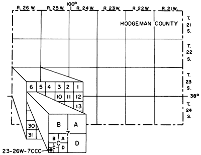
The system of numbering wells and test holes in this report is based on the U.S. Bureau of Land Management's system of land subdivision. The number shows the location of the well or test hole by township, range, section, and position within the section. The first number indicates the township; the second, the range west or east of the sixth principal meridian; and the third, the section in which the well is located. The letters following the section number locate the well within the section. The first letter denotes the quarter section or 160-acre tract; the second, the quarter-quarter section or 40-acre tract; and the third, the quarter-quarter-quarter section or 10-acre tract. The letters are assigned in a counterclockwise direction beginning with A in the northeast quarter of the section. Letters are assigned to each 160-, 40-, and 10-acre tract in the same manner. For example, well 23-26W-7CCC, in Hodgeman County, is located in the southwest quarter of the southwest quarter of the southwest quarter of sec. 7, T.23 S., R.26 W. (fig. 2).
Figure 2--System of numbering wells and test holes in Kansas.
The Cheyenne Sandstone (the lower formation) generally is considered to be of continental origin, and to have been deposited on a mature, eroded surface consisting of Permian and Jurassic rocks. Deposition was on or near the strand line of a transgressing sea advancing northward through the interior regions of the United States.
The Kiowa Formation (the middle formation), of marine origin, was deposited in a transgressing sea. Thinning and eventual absence of the Kiowa in the northern and eastern part of Kansas indicate that the formation probably was deposited near the margins of the sea. As sea level continued to rise in relation to the surrounding land mass, late Kiowa deposits overlapped the Cheyenne Sandstone and early Kiowa deposits. The increase of sandstone in the late Kiowa deposits in the northern part of the outcrop area may be an indication of regressive sedimentation that preceded deposition of the Dakota Formation.
The Dakota Formation (the upper formation) generally is considered to have been deposited under marine conditions in a regressing sea, and under nonmarine conditions in a bordering low-lying coastal or deltaic plain. This sea was in a regressive phase resulting in younger Dakota sediments being deposited progressively farther to the west. Fluctuations in the shore line during the regressive phase may account for the presence of marine brackish-water invertebrates in the upper part of the Dakota. The largely marine character of subsurface equivalents of the Dakota Formation, described in northwestern Kansas by Merriam (1957) and others, shows that nonmarine sediments grade westward into marine sediments.
The Cheyenne Sandstone crops out only in Barber, Kiowa, Comanche, and Clark counties in south-central Kansas. The Cheyenne is mainly a light-colored, fine- to medium-grained, friable, crossbedded sandstone containing lenses of sandy shale, conglomerate, and minor amounts of clay (O'Connor, 1968). Subsurface samples of Cheyenne are almost entirely of white, fine- to medium-grained, loose or slightly cemented sandstone. On the outcrop, the thickness of the unit ranges from 33 to 94 feet. In the subsurface, the formation has a maximum thickness of about 300 feet. Abrupt changes in thickness within short distances may be the result of deposition on the eroded pre-Cretaceous surface, which had considerable local relief.
The Kiowa Formation, which conformably overlies the Cheyenne Sandstone, was named from rock exposures in Kiowa County where the formation is best exposed. The formation also is exposed in parts of north-central Kansas. This formation is mainly a medium- to dark-gray, micaceous, silty, soft to hard, marine shale containing thin beds of limestone, sandstone, and bentonite (Franks, 1966). Gypsum commonly occurs as dispersed selenite crystals. Limestones, which occur in thin stringers, are chiefly coquinas of shell fragments. The "Champion shell bed," near the base of the formation, seemingly is not traceable out of the type area. Maximum thickness of the Kiowa is about 380 feet, and the average thickness is about 100 feet. Some of the wide ranges in thickness may reflect the uncertainty in determining the upper boundary of the formation owing to the increase of sandstone in late Kiowa deposition.
The Dakota Formation in Kansas consists of alternate beds or lenses of claystone, siltstone, and sandstone (Franks, 1966). As much as 70 percent of the formation is estimated to consist of lenticular beds of claystone and siltstone. In the outcrop area, the beds pinch or swell and grade laterally in color or lithology, and contain lignite beds locally. Cross stratification is a prominent feature of the sandstone in the Dakota Formation. Most of the sandstone is friable and lightly stained with iron oxides. Sandstone occurs in erratically distributed lenses that differ in thickness and extent of interconnection. Although little information is available concerning the size and shape of sandstone lenses in the Dakota, some lenses may have wide areal extent. The thickness of the Dakota Formation ranges from as much as 330 feet to only a few feet in areas where most of the formation has been removed by erosion.
Structure contours of the top of the Lower Cretaceous rocks and the principal structural elements within the area are shown on figure 3. The Salina Basin and the Western Kansas Basin are separated by positive elements of the Cambridge Arch and the Central Kansas Uplift (fig. 3). These positive elements are parts of an older structural element called the Ellis Arch or the Ancestral Central Kansas Uplift that was active in pre-Mississippian time. The Central Kansas Uplift was active in Mississippian time, but was not active in post-Paleozoic time, as is indicated by the lack of structural deformation of the top of the Lower Cretaceous rocks. Continued activity of the Cambridge Arch is shown by upwarping on top of Lower Cretaceous rocks.
Figure 3--Structure contours of top of Lower Cretraceous rocks and boundaries of principal structureal features.
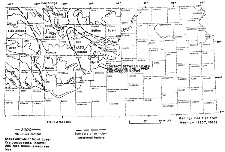
The boundary of the Western Kansas Basin is not well defined by the structure contours in the eastern part, but is well defined in the western part. An abrupt change in slope indicated by the structure contours marks the boundary between the Western Kansas Basin and the Las Animas Arch. The increase in slope westward from this boundary reflects the continued uplift of the Las Animas Arch after deposition of the Lower Cretaceous rocks.
The depth below the land surface to the top of the Lower Cretaceous rocks is shown on a generalized map (pl. 1). In areas where the rocks have been partly eroded, that surface may be represented by beds within the Dakota Formation, Kiowa Formation, or Cheyenne Sandstone. Areas where the Lower Cretaceous rocks crop out or are covered only by a thin regolith are delineated. The extent of Lower Cretaceous rocks is shown by the dashed boundary (modified from Merriam, 1963).
Lower Cretaceous rocks occur at a depth of about 100 feet in the extreme southwestern part of the State and at a depth of about 2,600 feet in northwestern Kansas, near the Colorado State line. The altitude of the land surface in northwest Kansas is several hundred feet higher than that in southwest Kansas, so the difference in land surface altitudes accounts for only a small part of the difference in the depths to the top of the formation. The structure contours of the top of the Lower Cretaceous rocks (fig. 3) indicate a gentle northward dip. The altitude of the top of the Lower Cretaceous rocks is about 3,500 feet above sea level in southwestern Hamilton County and about 1,250 feet in Cheyenne County; a difference of 2,250 feet.
South of the Arkansas River in southwestern Kansas (fig. 4), Lower Cretaceous rocks are directly overlain by unconsolidated Cenozoic (Pliocene and Pleistocene) deposits ranging in thickness from only a few feet to as much as 500 feet.
Figure 4--Map of southwestern Kansas showing area where Lower Cretaceous rocks are directly overlain by Pliocene and Pleistocene deposits.
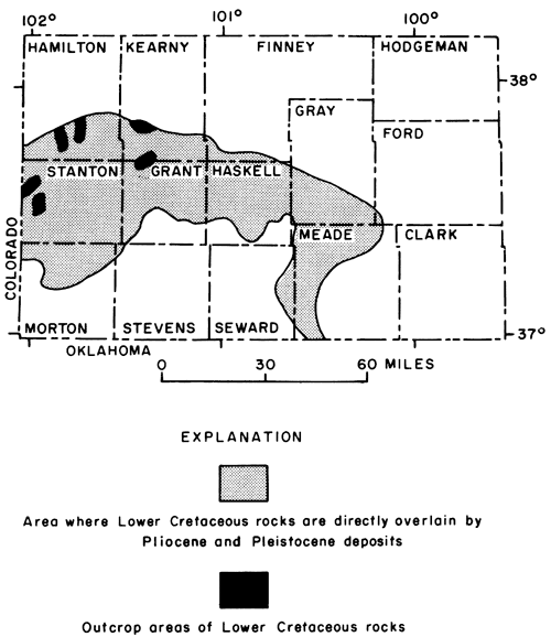
In northwestern Kansas, as much as 2,300 feet of Upper Cretaceous rocks, which are principally shale, chalk, and limestone, separate Cenozoic deposits from the Lower Cretaceous rocks. Both the Upper Cretaceous rocks and the unconsolidated Cenozoic deposits thin eastward from-the Colorado State line.
On plate 1, major stream valleys and local topographic features are reflected in the depth to the top of the Lower Cretaceous rocks. Some structural features also are evident, such as the syncline in Logan, Scott, and Finney Counties near the west edge of the Western Kansas Basin (fig. 3). A deep syncline, not evident on the map of the depth to the top of Lower Cretaceous rocks, occurs in Lane and Gove Counties where Lower Cretaceous rocks attain their maximum thickness of 850 feet.
The thickness of sandstone units in the Lower Cretaceous rocks is shown on plate 2. The thickness shown at any location represents the aggregate thickness of sandstone, and may consist of one or more beds of sandstone. In the eastern and southeastern part of the area, less sandstone is present than in the northern or western part. This difference is attributed to the absence of sandstone in the Kiowa Formation and to the thinning or absence of the Cheyenne Sandstone. In the Salina Basin area (fig. 3), the Cheyenne and Kiowa are thin or absent. The abnormally thick sandstone, which is as much as 400 feet, trending through Gove, Lane, Finney, and northern Ford Counties (pl. 2) is coincident with the thick Lower Cretaceous rocks in the synclinal structure on the west side of the Western Kansas Basin.
Lower Cretaceous rocks are an important source of ground water in parts of central and western Kansas where supplies are not available from overlying Cenozoic deposits. In many areas, these rocks yield only enough water to wells for domestic or stock use; locally, wells yield as much as 2,000 gpm.
Generally the Lower Cretaceous rocks are described as containing two aquifers--the Cheyenne Sandstone and the Dakota Formation--separated by a relatively impermeable unit-the Kiowa Formation. However, the Cheyenne contains thin beds of impermeable siltstone, the Kiowa Formation contains permeable sandstone beds locally, and about 70 percent of the Dakota is composed of relatively impermeable siltstone and claystone with the remaining 30 percent of permeable sandstone beds. Thus the many sandstone beds of the three formations form the principal aquifers of the Lower Cretaceous rocks. Their ability to yield water to wells depends largely on areal extent, thickness, and interconnection of the beds, and on grain size and cementation of the sand.
The sandstone beds in the Cheyenne have greater continuity and areal extent than those of the Kiowa or Dakota Formations. Owing to the considerable relief of the underlying surface and subsequent erosion of the formation, the thickness of a sandstone bed may change markedly in a relatively short distance. Other factors that contribute to the relatively large yield of wells that tap the Cheyenne are uniformity of grain size and generally loose cementation of the sand. In areas of fine to medium, loosely cemented sand, the formation is capable of freely transmitting water. In areas of very fine, silty sandstone, the capability of the formation to transmit water is reduced.
Appreciable quantities of sandstone are present in the upper part of the Kiowa Formation in its northeastern outcrop area and in other local areas. The sandstone generally occurs in thin discontinuous beds, but may be several tens of feet thick locally. Sand in the Kiowa differs considerably in grain size and cementation. The Kiowa is not an important aquifer except in those areas near the outcrop where the sandstone is highly weathered, and in areas where the Cheyenne and Dakota are thin or absent.
Sandstones in the Dakota Formation comprise the most important aquifer of the Lower Cretaceous rocks in Kansas. These sandstones are thin-bedded to massive, and occur in lenses that differ in thickness and areal extent. The size and shape of the sandstone lenses are difficult to determine, but the lenses commonly are elongated in the general direction of dip of the cross stratification of the beds (Bayne and others, 1971, p. 19). The dip of cross stratification in central Kansas indicates that the direction of transport of the sand composing the lenses trended in a westward and southwestward direction. Laterally, the sandstone lenses may pinch out or grade into sequences of siltstone or shale.
Many of the sandstones are loosely cemented with limonite; a few are tightly cemented with calcium carbonate, silica, or iron, and others have no cementation. Fine sand predominates, but grain size ranges from very fine sand to coarse sand. Generally, wells tapping the thin sand lenses near the top of the Dakota Formation obtain sufficient water for domestic or stock use. Wells tapping thick, loosely cemented, saturated sand lenses yield supplies adequate for irrigation.
The porosity of the sandstone beds in the Lower Cretaceous rocks, which differs greatly depending on grain size and. degree of cementation, may range from less than 5 to more than 30 percent. The effective porosity or the interconnected pore space available for transmitting water through the aquifer probably ranges from 10 to 25 percent.
The amount of water that may be withdrawn from storage (specific yield) in an unconfined aquifer is approximately equal to the effective porosity minus specific retention (the volume of water retained against drainage by gravity). Specific yields of as much as 15 to 20 percent have been determined from the few pumping tests run on wells tapping the unconfined part of the Lower Cretaceous aquifers.
In confined aquifers, the yield of water from storage also is affected by expansion of the water and compression of the aquifer over a large area. Thus, the specific yield of a confined aquifer may be three to four orders of magnitude smaller than that of an unconfined aquifer. When the water level in wells is drawn below the top of the confined aquifer, however, water will begin to drain by gravity and the specific yield will approach that of an unconfined aquifer. To determine the amount of water that ultimately could be available from storage after gravity drainage begins, a yield of 3 to 5 percent is estimated for the presently confined part of the Lower Cretaceous aquifers.
The potentiometric surface of water in the Lower Cretaceous rocks is shown in figure 5. The highest point on this surface occurs in western Hamilton County coinciding with the structural high, as shown on figure 3. The potentiometric surface slopes in an east-northeasterly direction toward the area of discharge. The contours are generalized owing to the limited amount of data in the outcrop areas and in the areas of existing well development. In the northern part of the State, where water in the formations generally is too highly mineralized for use, measurements of potentiometric head are not available.
Figure 5--The generalized potentiometric surface of water in Lower Cretaceous rocks.
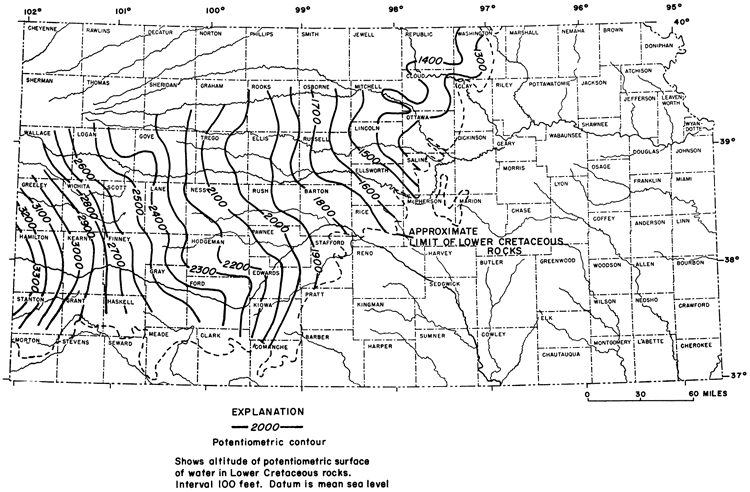
In an area bounded on the west by the Colorado State line and on the north by the Arkansas River (fig. 4), and extending eastward to the limit of Lower Cretaceous rocks, saturated unconsolidated Cenozoic deposits commonly are in direct contact with and probably contribute recharge to underlying sandstones. Only limited data are available on the differences in potentiometric head of water contained in the respective aquifers. Generally, the potentiometric surface in the Cenozoic aquifer is several tens of feet higher than the potentiometric surface in the Lower Cretaceous aquifer. Therefore, water from the Cenozoic deposits can recharge the Lower Cretaceous rocks; the water subsequently moves down dip in a northeasterly direction. In the area north of the Arkansas River and 100 to 150 miles east of the State line, the presence of potable water in the Lower Cretaceous rocks probably is due to flushing of highly mineralized water by the recharge mechanism in southwestern Kansas and the underflow from southeastern Colorado. The area in northwestern Kansas contains highly mineralized water that may be connate water altered to some degree by ion exchange.
On the outcrop in central Kansas, Lower Cretaceous rocks are recharged in part from local precipitation.
Ground water that is confined under pressure in an aquifer between two beds of low permeability is regarded as artesian or confined water. When a well is drilled into the aquifer, water will rise in the well above the top of the producing bed. A flowing artesian well is one in which the water rises in the well to a point above the land surface. In the classic artesian system, water entering the aquifer in the recharge area moves down dip toward an area where water in wells will rise above the top of the formation as a result of the pressure head.
Most of the Lower Cretaceous rocks in Kansas are part of an artesian system in which the sandstone beds are the aquifers and the shales in the Permian and Jurassic rocks below and in the Upper Cretaceous rocks above form relatively impermeable confining beds. Clay and shale within the Lower Cretaceous rocks also act as confining or semiconfining beds. The water in many wells in the outcrop areas is under artesian pressure, but commonly does not flow at the land surface.
Comparison of data on figures 3 and 5 indicate that the pressure head is great enough to raise water in wells only a few feet above the Lower Cretaceous surface in or near the outcrop area, but the potentiometric surface may be as much as 550 feet above the top of the aquifers in the central and western part of the area.
Most wells that obtain water from the Lower Cretaceous rocks in Kansas are domestic and stock wells, which discharge only small quantities of water and have no noticeable effect on the potentiometric surface. Extensive development of irrigation wells that yield 500 to 1500 gpm in local areas in northern Ford and southern Hodgeman Counties, however, has caused local changes in the shape and slope of the potentiometric surface because of the considerable lowering of the pressure head in the vicinity of the wells.
Haworth (1913) reported artesian flows of 75 gpm from Lower Cretaceous rocks near Coolidge in western Hamilton County. McLaughlin (1943) reported flows of less than 1 to more than 25 gpm in this same area. The decrease in flow may be, in part, due to partial plugging of the wells or a reduction in head in the aquifer. All but one of the flowing wells obtained water from the Cheyenne Sandstone, the deepest aquifer in this area, which occurs at depths of 250 to 300 feet.
Water under artesian head reportedly was obtained from both the Cheyenne Sandstone and Dakota Formation near Coolidge, Kans. (McLaughlin, 1943). In the shallowest aquifer, a sandstone near the top of the Dakota, water in wells rose to levels of 25 feet below to 5 feet above the water level in the Arkansas River alluvium. Some wells reportedly obtained water from a deeper sandstone within the Dakota Formation.
In nature, a ground-water reservoir functions as a hydraulic system that is in dynamic balance. On the average, the potentiometric surface remains in a relatively fixed position because recharge is equal to discharge. Seasonal or annual changes in precipitation may affect recharge and result in temporary changes in the position of the potentiometric surface. If the amount of water discharged from an aquifer significantly exceeds the recharge for a period of time, the potentiometric surface will decline. Conversely, when recharge significantly exceeds discharge, the potentiometric surface will rise.
Discharge by wells is an additional discharge superimposed on the natural system, which will cause an additional lowering of the potentiometric surface. Before a new equilibrium can be established, the additional discharge must be balanced by increased recharge or reduced natural discharge to seeps and streams.
Hydrographs record the change in water level in a well. Water-level changes shown on a hydrograph may indicate a changing trend in the potentiometric surface. These records, however, must be correlated with precipitation and pumpage records to evaluate the cause and effect of the fluctuations. Erroneous interpretations may be made when short-term records are used.
In some areas, changes in the rate of recharge resulting from increased precipitation or drought may be observed in a few months on the hydrograph of a well. In other areas, many months may elapse before changes may be observed. The differences in the time interval may be due to distance of the observation well from the recharge area, differences in permeability of the sandstone beds composing the aquifer, differences in the degree of interconnection of the sandstone beds with the recharge area, or to the degree of confined or unconfined conditions in the aquifer system.
The effects of pumpage are indicated on the hydrograph by a lowering of the water level. The amount of lowering is dependent on the rate of pumping, duration of pumping, distance from the area of pumping, hydraulic conductivity of the aquifer, interconnection of the sandstone beds, or the confined- or unconfined-aquifer conditions.
The hydrograph of well 26-42W-17CB in Hamilton County (fig. 6) shows the water-level trend for a period of about 9 years. This well, which is 749 feet deep, penetrates all the Lower Cretaceous rocks and part of the Jurassic rocks. The well has a reported yield of about 2,200 gpm. The general occurrence of low water levels in the summer and high water levels in late winter or early spring reflect seasonal fluctuations as a result of pumping for irrigation. Seasonal fluctuations commonly are 10 feet or less, and the maximum change in water level for the period of record is 19 feet. Because the well is in the area where Lower Cretaceous rocks probably receive recharge from overlying Cenozoic deposits, seasonal fluctuations and subsequent lowering of the potentiometric surface are relatively small.
Figure 6--Hydrographs of selected wells in Hamilton, Hodgeman, and Ford counties.
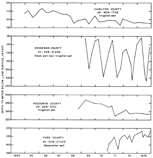
The hydrograph of well 22-23W-31ADD near Jetmore in Hodgeman County (fig. 6) shows the water-level trend for a period of about 5 years. This small-diameter stock well, which is 315 feet deep, partially penetrates the confined aquifer in the Lower Cretaceous rocks. An irrigation well and the city wells of Jetmore, located in the same quarter section, also withdraw water from the Lower Cretaceous rocks.
Annual fluctuations of the water level in the stock well range from about 75 to 100 feet with seasonal lows occurrincg in the summer and seasonal highs occurring in the early spring. These changes in the water level reflect the influence of water use for irrigation and the increase in water use during the summer by the city of Jetmore. Withdrawals by the municipal and irrigation wells probably cause the water level in the stock well to decline below the top of the aquifer so that unconfined conditions are reflected during part of the year. The hydrograph shows a progressive lowering of the potentiometric surface during the irrigation season from year to year, probably indicating that pumpage in this area exceeds the recharge capability of the aquifer.
Well 23-26W-7CCC in western Hodgeman County is an irrigation well 500 feet deep that penetrates the Lower Cretaceous rocks. The water level (bead) in this well initially was only a few feet above the top of the aquifer, and the hydrograph (fig. 6) indicates a progressive lowering of the bead. Continued lowering of the water level may reduce the pressure bead at this well so that the aquifer functions as an unconfined system. The 1912-73 record on the hydrograph may be an indication that this change has already occurred.
Well 25-22W-27CCD, near Spearville in Ford County, is 240 feet deep and penetrates the Lower Cretaceous rocks. This well is cast of an area where irrigation wells yield 1,200 to 1,400 gpm from a confined aquifer in the Lower Cretaceous rocks. The hydrograph (fig. 6) indicates that water levels during 1970-73 were low during the summer irrigation season and high during late winter or early spring. This well record shows a progressive rise in water level during the period. The well is screened in an artesian aquifer so that the potentiometric surface normally would be lowered as a result of irrigation pumpage. The progressive rise in the water level suggests that the sandstone may be receiving recharge from interconnecting sand lenses that is in excess of discharge. Inferences drawn from this hydrograph, however, must be made with caution because of the short period of record. Pumpage prior to 1970 may have greatly exceeded the 1970-73 rate so that the recovery of artesian pressure might give an erroneous impression of rising water levels due to recharge, when in fact it may be due to recovery of water levels from heavy pumping in previous years.
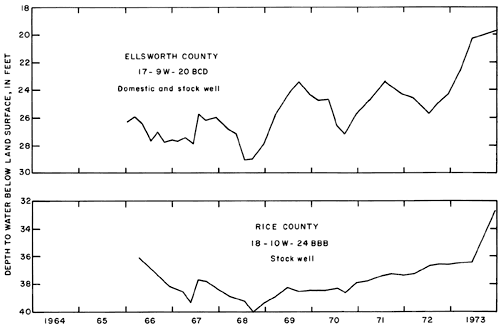
Well 17-9W-20BCD in Ellsworth Couuty and well 18-10W-24BBB in Rice County (fig. 7) are both small-diameter domestic and stock wells that produce water from Lower Cretaceous rocks. The well in Ellsworth County is 63 feet deep and penetrates only a few feet of the Lower Cretaceous rocks. The well in Rice County is 144 feet deep and penetrates about 90 feet of Lower Cretaceous rocks. At both wells, the Lower Cretaceous rocks are overlain by about 50 feet of Pleistocene silt deposits, the lower part of which is saturated. The hydrographs of these wells (fig. 7) show a general similarity through 1970, except that the well in Ellsworth County displays much greater fluctuations than the well in Rice County. Although the water levels in both wells have continued to rise since 1970, detailed similarity in the hydrographs is lacking. Tests on wells of large yield indicate that hydraulic connection between the Lower Cretaceous rocks and overlying Cenozoic rocks commonly is poor. Hydrographs of the two wells, however, suggest that they are being recharged locally from shallow unconsolidated deposits or from precipitation on the nearby outcrop.
Figure 7--Hydrographs of selected wells in Ellsworth and Rice Counties.
The term "water quality," as applied here, embraces the combined physical and chemical characteristics distinctive to a given water in relation to its use. Water is vital to the existence of all life and is essential, either directly or indirectly, to almost all activities of man. Quality is a dominant factor in determining the adequacy of any water supply to satisfy the requirements of man's uses.
One of the primary purposes of this study is to define the chemical quality of water from Lower Cretaceous rocks and to describe its adequacy for man's use. In many areas of Kansas, water of good quality is in short supply. Water from Lower Cretaceous rocks is available in some of these areas, but the water may be too highly mineralized for most uses. It is possible, however, that some of this water may become an important resource through desalinization in the future.
People easily develop a tolerance for slightly saline water as evidenced by the fact that more than 100 public water supplies in the United States have a dissolved solids content of 2,000 mg/l or more (U.S. Public Health Service, 1962, p. 33). Several municipalities in Kansas use water containing more than 2,000 mg/l. The number of domestic supplies that use water containing more than 2,000 mg/l is unknown.
Data from chemical analyses of water from about 560 wells that obtain water from the Lower Cretaceous rocks were used to prepare the map showing chemical quality of water (pl. 3). This map shows the location of wells for which analyses were available, ranges in concentrations of dissolved solids and chlorides, and the type of water classed by predominant ions as indicated by the analyses. Lines of equal concentrations of dissolved solids are drawn to show the ranges in salinity of the contained water. In this report, the salinity has been classified in terms of dissolved solids (Winslow and Kister, 1956) as follows:
| Dissolved-solids Concentration (milligrams per liter) |
|
|---|---|
| Fresh | Less than 1,000 |
| Slightly saline | 1,000 to 3,000 |
| Moderately saline | 3,000 to 10,000 |
| Very saline | 10,000 to 35,000 |
| Brine | More than 35,000 |
The Kansas Department of Health and Environment recommends a limit of 500 mg/l dissolved solids in drinking water, but water containing 500 to 1,000 mg/l is accepted as usable where better quality water is not available. Several municipalities that use water containing more than 2,000 mg/l dissolved solids are searching for new sources of supply. It is considered probable that, in future years, it will be economically feasible to desalinize water containing as much as 3,000 mg/l dissolved solids for municipal or industrial use.
Much of the chemical-quality data used in the preparation of plate 3 was available for the eastern and southern parts of the area underlain by Lower Cretaceous rocks. In the remainder of the area, only limited data are available. Many test wells reportedly yielding "salty" water have been plugged so that qualitative information is not available. Some generalized interpretations have been made on the basis of geophysical logs of oil and gas test wells. Thus, the delineation of areas of slightly saline water (1,000 to 3,000 mg/l dissolved solids) in the western part of the State is based on tenuous information. The delineation of areas of moderately saline water (3,000 to 10,000 mg/l dissolved solids) is extrapolated on the basis of known data and inferred trends.
The range in concentrations and significance of selected chemical constituents in water from wells in Lower Cretaceous rocks is given in table 1. The chemical composition of water from wells in the Lower Cretaceous is interpreted from 84 partial analyses of water samples from selection wells given in table 2.
Table 1--Range in concentrations and significance of selected chemical constituents in water from Lower Cretaceous rocks.
| Constituent | Range in concentration (mg/l) |
Significance (U.S. Public Health Service, 1962, p. 33, 49.) |
|---|---|---|
| Calcium | 1.2-755 | Calcium and magnesium combine with bicarbonate, carbonate, sulfate, and silica to form scale in heat exchange equipment; contribute to hardness in water; and, in irrigation water, are desirable for normal plant growth and for maintenance of soil tilth. High concentrations of magnesium in drinking water may have a laxative effect |
| Magnesium | .5-13 | |
| Sodium | 4.0-2,930 | Sodium ions, in exchange for calcium and magnesium ions, reduce hardness of water, but high concentrations in irrigation water may adversely affect permeability of soils. |
| Bicarbonate | 29-1,350 | Bicarbonate contributes to alkalinity in water; tends to form carbonate that combines with calcium and magnesium to produce scale in heat exchange equipment. |
| Sulfate | .8-1,780 | Sulfate in concentrations of more than 500 mg/l imparts a bitter taste in drinking water; high concentrations may combine with magnesium or sodium to produce a laxative effect. |
| Chloride | 4.0-4,590 | Chloride in concentrations of more than 250 mg/l imparts a bitter taste in drinking water; high concentrations in irrigation may be detrimental to plant growth. |
| Fluoride | Fluoride concentrations of 1.0 mg/l generally desirable to prevent dental cavities during formation of permanent teeth in children; concentrations of more than 1.5 mg/l cause mottled enamel. | |
| Nitrate | Nitrate concentrations of more than 45 mg/l in drinking water may cause methemoglobinemia when used in infant feeding. |
In considering the usability of water from the Lower Cretaceous rocks for municipal and domestic supplies, the concentrations of chloride are a significant factor. The Kansas Department of Health and Environment recommends a limit of 250 mg/l chloride in drinking water. Results of 84 partial chemical analyses (table 2) showed concentrations of chloride to be more than 250 mg/l in 12 of the samples; more than 500 mg/l in 7 of the samples; and more than 1,000 mg/l in 4 of the samples. These and other data used in the interpretation of plate 3 indicate that the concentration of chlorides in the fresh to moderately saline water areas of the Lower Cretaceous rocks range from less than 10 to about 4,600 mg/l. It is assumed for purposes of this report that appropriate methods of desalinization in future years will provide economically feasible treatment of water containing as much as 500 mg/l dissolved chlorides for use in municipal and domestic supplies. For this reason, the area where the concentration of chlorides in water from wells generally would be less than 500 mg/l has been delineated on plate 3.
Table 2--Partial chemical analyses of water from selected wells in Lower Cretaceous rocks. [Dissolved constituents in milligrams per liter. Analyses by the Kansas Department of Health and Environment.]
| Well location |
Depth to water, in feet |
Depth of well, in feet (S, spring) |
Dissolved calcium (Ca) |
Dissolved magnesium (Mg) |
Dissolved sodium (Na) |
Dissolved bicarbonate (HCO3) |
Dissolved sulfate (SO4) |
Dissolved chloride (Cl) |
Dissolved solids (evaporated at 180° C) |
|---|---|---|---|---|---|---|---|---|---|
| Clay County | |||||||||
| 10-1E-17DC2 | 110 | 21 | 2.8 | 27 | 95 | 20 | 21 | 159 | |
| Cloud County | |||||||||
| 6-2W-33DC | 235 | 53 | 13 | 105 | 305 | 52 | 75 | 465 | |
| 6-4W-34CC | 380 | 96 | 8.9 | 30 | 351 | 32 | 13 | 378 | |
| Edwards County | |||||||||
| 23-19W-9CC | 42 | 67 | 72 | 40 | 98 | 262 | 294 | 21 | 666 |
| 23-20W-16DD | 111 | 124 | 42 | 24 | 79 | 298 | 88 | 22 | 415 |
| Ellis County | |||||||||
| 15-18W-9BB | 137 | 270 | 562 | 89 | 341 | 280 | 1780 | 298 | 3250 |
| 15-18W-33BA | 36 | 154 | 18 | 13 | 770 | 334 | 264 | 860 | 2100 |
| 15-19W-4AD | 137 | 290 | 77 | 25 | 208 | 304 | 306 | 125 | 908 |
| 15-19W-27DA | 75 | 156 | 85 | 15 | 28 | 342 | 32 | 12 | 388 |
| Ellsworth County | |||||||||
| 14-9W-34ADB | 63 | 102 | 8.2 | 18 | 305 | 21 | 29 | 364 | |
| 15-10W-36CCB | 152 | 144 | 55 | 714 | 373 | 171 | 1170 | 2448 | |
| 16-10W-26CCC | 111 | 96 | 11 | 22 | 317 | 15 | 40 | 362 | |
| Finney County | |||||||||
| 22-27W-14BD | 161 | 485 | 11 | 1.1 | 176 | 244 | 106 | 77 | 508 |
| 23-29W-12CCC | 450 | 8.0 | 2.0 | 140 | 249 | 80 | 29 | 206 | |
| Ford County | |||||||||
| 25-21W-35AB | 45 | 155 | 44 | 24 | 35 | 283 | 22 | 15 | 289 |
| 25-22W-24AB | 156 | 30 | 23 | 114 | 312 | 103 | 33 | 464 | |
| 29-26W-24BC | 34 | 212 | 51 | 16 | 14 | 243 | 11 | 4.5 | 223 |
| 29-26W-34AD | 154 | 56 | 20 | 21 | 284 | 17 | 6 | 269 | |
| Gove County | |||||||||
| 14-26W-14DC | 696 | 4.5 | 2.2 | 434 | 562 | 176 | 213 | 1127 | |
| 14-27W-11DC | 717 | 2.4 | o.5 | 370 | 620 | 86 | 137 | 923 | |
| Grant County | |||||||||
| 28-38W-7AB | 146 | 610 | 45 | 20 | 125 | 215 | 263 | 17 | 597 |
| Gray County | |||||||||
| 28-27W-24BA | 204 | 420 | 8.0 | 4.7 | 150 | 266 | 119 | 9.5 | 433 |
| 29-28W-4AA | 130 | 365 | 27 | 10 | 70 | 207 | 75 | 5.5 | 296 |
| Greeley County | |||||||||
| 17-42W-36BBB | 1140 | 18 | 8.8 | 377 | 446 | 212 | 217 | 1065 | |
| Hamilton County | |||||||||
| 21-40W-28DC | 539 | 784 | 9.6 | 7.8 | 255 | 395 | 222 | 46 | 755 |
| 22-41W-33DC | 360 | 585 | 18 | 6.6 | 90 | 207 | 88 | 12 | 332 |
| 22-43W-4DD | 370 | 516 | 20 | 9.7 | 161 | 243 | 186 | 29 | 531 |
| 23-40W-32CC | 170 | 260 | 52 | 37 | 187 | 238 | 382 | 63 | 844 |
| 25-39W-22DC | 270 | 44 | 29 | 49 | 307 | 67 | 10 | 373 | |
| 25-42W-24AC | 310 | 380 | 54 | 22 | 56 | 217 | 154 | 13 | 424 |
| 26-40W-14BBA | 610 | 57 | 31 | 64 | 276 | 162 | 13 | 480 | |
| Hodgeman County | |||||||||
| 22-21W-25AA | 79 | 126 | 5.6 | 3.8 | 33 | 72 | 9 | 16 | 111 |
| 23-21W-2BB | 149 | 207 | 47 | 27 | 44 | 303 | 44 | 17 | 337 |
| 23-23W-6B7 | 405 | 18 | 10 | 180 | 276 | 74 | 129 | 577 | |
| 23-26W-7CCC | 302 | 490 | 53 | 15 | 58 | 217 | 54 | 60 | 380 |
| Jewell County | |||||||||
| 5-6W-26BA | 17 | 138 | 198 | 20 | 43 | 382 | 93 | 71 | 800 |
| 5-6W-34CD | 99 | 100 | 418 | 43 | 251 | 293 | 778 | 375 | 2246 |
| Kiowa County | |||||||||
| 30-18W-2DC | S | 61 | 14 | 37 | 273 | 21 | 28 | 300 | |
| 30-18W-11CB | S | 48 | 9.8 | 15 | 207 | 13 | 4.2 | 196 | |
| Lane County | |||||||||
| 16-28W-4BCD | 344 | 673 | 4.8 | 2.8 | 303 | 483 | 77 | 120 | 772 |
| 18-29W-15D | 859 | 19 | 11 | 200 | 324 | 160 | 56 | 642 | |
| 19-30W-30ADD | 500 | 1038 | 11 | 5.2 | 238 | 331 | 154 | 67 | 669 |
| Lincoln County | |||||||||
| 10-10W-14DA | 152 | 206 | 97 | 11 | 38 | 342 | 73 | 8.0 | 407 |
| 11-8W-36AA | 200 | 125 | 48 | 66 | 342 | 265 | 45 | 766 | |
| 13-10W-25DC | 88 | 130 | 115 | 26 | 57 | 378 | 154 | 32 | 576 |
| Logan County | |||||||||
| 12-33W-33BBD | 800 | 1387 | 5.6 | 0.5 | 420 | 722 | 230 | 1033 | |
| 14-33W-22CDD | 895 | 4.0 | 1.0 | 350 | 446 | 234 | 70 | 930 | |
| 14-35W-17BCA | 1335 | 4.8 | 1.0 | 324 | 595 | 88 | 69 | 826 | |
| Marion County | |||||||||
| 17-1E-27CCB | 12 | 37 | 6.7 | 23 | 76 | 42 | 15 | 246 | |
| McPherson County | |||||||||
| 19-1W-21 | 53 | 90 | 13 | 52 | 381 | 49 | 17 | 468 | |
| Mitchell County | |||||||||
| 7-6W-24CDD | 38 | 40 | 256 | 52 | 90 | 376 | 668 | 30 | 1295 |
| 7-7W-11CBB | 60 | 145 | 127 | 23 | 562 | 654 | 320 | 540 | 1907 |
| 9-6W-29AAA | 135 | 190 | 52 | 12 | 112 | 366 | 83 | 21 | 479 |
| Ness County | |||||||||
| 16-26W-23C | 800 | 7.2 | 4.4 | 364 | 363 | 160 | 252 | 969 | |
| Ottawa County | |||||||||
| 9-1W-26BCB | 92 | 74 | 23 | 56 | 220 | 176 | 24 | 472 | |
| 9-5W-15CDC | 76 | 99 | 112 | 27 | 64 | 444 | 139 | 9 | 591 |
| 11-3W-6BCA | 215 | 65 | 12 | 39 | 243 | 51 | 19 | 364 | |
| Pawnee County | |||||||||
| 20-16W-13CA | 165 | 91 | 18 | 20 | 290 | 85 | 8.5 | 374 | |
| 21-18W-32BBB | 306 | 56 | 17 | 86 | 293 | 37 | 80 | 423 | |
| 22-19W-29CC | 100 | 42 | 22 | 118 | 351 | 76 | 54 | 527 | |
| Republic County | |||||||||
| 1-1W-28AA | 244 | 34 | 8.8 | 223 | 434 | 169 | 46 | 707 | |
| 4-5W-23BC | 128 | 19 | 15 | 1526 | 920 | 258 | 1655 | 4018 | |
| 4-5W-30BB | 84 | 124 | 8.8 | 30 | 296 | 39 | 65 | 462 | |
| Rice County | |||||||||
| 19-8W-22CCC | 125 | 93 | 7.8 | 39 | 295 | 14 | 69 | 396 | |
| Rush County | |||||||||
| 16-18W-27CDD | 209 | 19 | 11 | 680 | 356 | 266 | 700 | 1867 | |
| 16-19W-17BAB | 400 | 8.3 | 16 | 363 | 398 | 183 | 243 | 1026 | |
| 18-18W-25DDA | 187 | 29 | 10 | 153 | 329 | 52 | 84 | 500 | |
| Russell County | |||||||||
| 11-12W-7DDB | 37 | 176 | 16 | 182 | 390 | 214 | 212 | 1114 | |
| 14-13W-12CB | 208 | 245 | 126 | 14 | 72 | 195 | 235 | 85 | 672 |
| 15-12W-31DD | 53 | 245 | 42 | 29 | 1163 | 458 | 345 | 1420 | 3252 |
| 15-14W-7AB | 159 | 174 | 22 | 21 | 1438 | 459 | 306 | 1815 | 3846 |
| Stanton County | |||||||||
| 27-39W-13AC | 115 | 508 | 86 | 39 | 51 | 256 | 237 | 21 | 596 |
| 29-42W-24CC | 222 | 515 | 55 | 23 | 54 | 240 | 118 | 15 | 419 |
| 29-42W-34CBD | 203 | 215 | 49 | 18 | 23 | 204 | 52 | 7 | 263 |
| 29-43W-14CCB | 28 | 108 | 74 | 21 | 50 | 220 | 158 | 18 | 439 |
| 29-43W-33CCD | 102 | 160 | 106 | 27 | 46 | 229 | 232 | 27 | 561 |
| 30-42W-16BD | 173 | 220 | 45 | 26 | 25 | 222 | 70 | 7.0 | 307 |
| Trego County | |||||||||
| 12-21W-24CDC | 665 | 16 | 10 | 180 | 307 | 101 | 61 | 556 | |
| 15-21W-25DDD | 555 | 8.3 | 12 | 476 | 415 | 220 | 368 | 1307 | |
| 15-22W-35ABA | 660 | 68 | 9.4 | 13 | 246 | 13 | 12 | 275 | |
| 15-24W-15CCC | 618 | 9.1 | 7.7 | 398 | 312 | 174 | 336 | 1090 | |
| Washington County | |||||||||
| 1-1E-7AA | 280 | 20 | 5.8 | 276 | 432 | 115 | 141 | 788 | |
| 1-2E-16BDD | 140 | 51 | 9.0 | 17 | 200 | 30 | 7.0 | 238 | |
| 5-3E-14CDC | S | 46 | 9.0 | 50 | 185 | 37 | 30 | 328 | |
In order to estimate the quantity of water in the Lower Cretaceous rocks that may be available for municipal and domestic use, the increasing demands for present and future supplies were considered. Therefore, it is assumed that Water containing less than 1,000 mg/l dissolved solids is usable at the present (1976); and that in future years water containing 1,000 to 3,000 mg/l dissolved solids and less than 500 mg/l chlorides may be available for use after appropriate desalinization.
To determine the available quantity of presently usable water, the area where concentrations of dissolved solids in water are less than 1,000 mg/l (pl. 3) was related to the thickness of sandstone (pl. 2) of that area and multiplied by the specific yield. It was assumed that the specific yield for the unconfined part of the aquifer would range from 0.15 to 0.20 and the specific yield for the confined part would range from 0.03 to 0.05 (p. 9). The quantity of water available for municipal and domestic use without significant treatment was estimated to be 70 to 80 million acre-feet. By relating the area where concentrations of dissolved solids are 1,000 to 3,000 mg/l and dissolved chlorides are less than 500 mg/l (pl. 3) to the thickness of sandstone (pl. 2) and assuming a specific yield of 0.03 to 0.05 (p. 9), the additional quantity of water that may become available in the future through desalinization is estimated to be 10 to 15 million acre-feet.
Because of the complex geohydrologic character of the multiple aquifer system in the Lower Cretaceous rocks, it is necessary to greatly generalize the interpretation of chemical-quality data as shown on plate 3. In local areas, the rocks may contain fresh water in one zone and saline water in another zone. In western Cloud County and eastern Mitchell County, fresh water is present in the upper part of the Dakota Formation and moderately saline to very saline water is present in the lower part. Similarly, in Russell and part of Barton counties, water in the Dakota Formation is fresh to slightly saline; whereas, the Cheyenne Sandstone contains very saline water.
Five types of water, classed on the basis of predominant ions, are indicated from the results of all available chemical-quality information. However, only four types of water are considered to be areally significant and are shown on the generalized map (pl. 3). Calcium bicarbonate water is the dominant type in areas where the sandstone is recharged from precipitation on the outcrop and in areas where the sandstone underlies or is in hydraulic connection with saturated Cenozoic deposits. Sodium chloride water occurs generally in the northern part of the area and in the Salina Basin area. Isolated areas of sodium chloride water occur in Kiowa, Pawnee, Barton, and Cloud counties, probably as a result of local contamination caused by disposal of oil-field brines. A zone containing a mixed sodium calcium bicarbonate water commonly occurs between the areas of sodium chloride and calcium bicarbonate water. The sodium calcium bicarbonate water probably results partly from ion exchange and partly from mixing the recharged calcium bicarbonate water with sodium chloride water in the sandstones. Calcium sulfate water is present locally along streams where calcium and sulfate ions probably are derived from solution of gypsum in the Kiowa Formation. Calcium chloride water, (not shown on plate 3) which commonly is contained only in deep formations, occurs locally as contamination from oil-field brines.
Maps showing the depth to the top of the Lower Cretaceous rocks (pl. 1), the approximate thickness of sandstones (pl. 2), the potentiometric surface (fig. 5), and the chemical quality of water (pl. 3) are shown in this report to aid those considering drilling into these rocks for a water supply. Owing to the scarcity of data, this information has been generalized on the maps.
As a result of structural deformation, Lower Cretaceous rocks dip from an altitude of about 3,500 feet in the southwest part of Kansas to an altitude of about 1,250 feet above sea level in the northwest and north-central part. Depth to the top of the Lower Cretaceous rocks increases from the outcrop areas on the east and south to about 2,600 feet in the northwest.
Lower Cretaceous rocks consist chiefly of claystone, siltstone, and sandstone deposited during successive stages of advancing and retreating seas. Claystone and siltstone compose nearly two-thirds of the Lower Cretaceous deposits. Sandstone of continental origin, which commonly occurs in elongate lenses, was deposited on coastal or deltaic plains. These lenses, which compose about one-third of the deposits thicken westward to a maximum of about 400 feet in central Lane County. The thickness of sandstones in the Lower Cretaceous rocks is more than 100 feet in most of western Kansas. Therefore, these rocks may contain potential aquifers from which large quantities of water may be withdrawn. The amount of water that can be pumped is related to the physical characteristics of the sand lenses including thickness, areal extent, degree of cementation, hydraulic conductivity of individual sand lenses, and the interconnection between lenses. In areas where loosely cemented sand lenses are interconnected, large amounts of water may be pumped by wells for long periods of time because of the amount of water in storage. If interconnection extends to the area of recharge, the amount of water available for pumping is greatly increased over those formations that are not directly connected to the recharge area. Information on well yields is limited by the small amount of testing in deep strata. Shallow wells commonly yield adequate supplies for domestic and stock use; reported yields from municipal and irrigation wells range from 100 to 2,000 gpm.
Recharge to the Lower Cretaceous rocks occurs in the area of outcrop and from overlying saturated Cenozoic rocks, especially in the south-central and southwestern part of the State. Movement of water is principally east-northeastward from areas of recharge toward areas of natural discharge.
Water in the Lower Cretaceous rocks generally is confined between underlying Permian or Jurassic rocks and overlying Upper Cretaceous rocks. As a result, in much of the report area, the water in wells will rise above the top of the aquifer and, locally, will flow at the land surface. Water levels in wells fluctuate in response to changes in atmospheric pressure and to changes in recharge and discharge. The greatest fluctuation results from discharge to wells for municipal and irrigation use. Water levels decline during the summer when municipal and irrigation withdrawals are large and rise during the subsequent winter and spring. In some areas, progressive local declines show that withdrawals (primarily for irrigation) are in excess of recharge. In other areas where water levels have shown little change, withdrawals probably are offset by recharge from overlying Cenozoic aquifers.
Quality of the water ranges from fresh (less than 1,000 mg/l) to very saline (10,000 to 35,000 mg/l). The concentration of dissolved solids and of chlorides increases as water moves away from areas of recharge. In this report, water containing less than 1,000 mg/l dissolved solids is considered to be usable for municipal and domestic supplies. About 70 to 80 million acre-feet of water are estimated to be available from sandstones of the Lower Cretaceous rocks. When demands become increasingly great in future years, water containing less than 3,000 mg/l dissolved solids and less than 500 mg/l dissolved chlorides probably can be desalinized for municipal or industrial use. Thus, an additional 10 to 15 million acre-feet of water probably can become available in future years.
Calcium bicarbonate water is the dominant type near outcrop areas and areas recharged from Cenozoic aquifers. Locally, high concentrations of sulfate probably indicate solution of gypsum from the Kiowa Formation and high concentrations of chlorides may be derived from disposal of oil-field brine. As water moves downgradient from recharge areas, a mixed sodium calcium bicarbonate water is dominant. At greater depths in the north-central and northwestern part of the State, sodium chloride water is dominant.
Bayne, C. K., Franks, P. C., and Ives, WWilliam, Jr., 1971, Geology and ground-water resources of Ellsworth County, Kansas: Kansas Geol. Survey, Bull. 201, 84 p. [available online]
Berry, D. W., 1952, Geology and ground-water resources of Lincoln County, Kansas, with a chapter on the chemical quality of ground water by W. H. Durum: Kansas Geol. Survey, Bull. 95, 96 p. [available online]
Berry, E. W., 1920, Age of the Dakota flora: Am. Jour. Sci., ser. 4, v. 50, p. 387-390.
Berry, E. W., 1922, The flora of the Cheyenne Sandstone of Kansas, in, Shorter contributions to general geology: U.S. Geol. Survey, Prof. Paper 129, p. 199-225. [available online]
Chow, V. T., ed., 1964, Handbook of applied hydrology, sec. 19 by Sheppard T. Powell, Quality of water: New York, McGraw-Hill, 1418 p.
Cobban, W. A., and Reeside, J. B., Jr., 1952, Correlation of the Cretaceous Formations of the western interior of the United States: Geol. Soc. America, Bull., v. 63, p. 1011-1044.
Cragin, F. W., 1894, Descriptions of invertebrate fossils from the Comanche Series in Texas, Kansas, and Indian Territories: Colorado Coll. Studies 5th Ann. Pub., p. 49-69.
Fader, S. W., Gutentag, E. D., Lobmeyer, D. H., and Meyer, W. R., 1964, Geohydrology of Grant and Stanton Counties, Kansas: Kansas Geol. Survey, Bull. 168, 147 p. [available online]
Fishel, V. C., 1948, Ground-water resources of Republic County and northern Cloud County, Kansas: Kansas Geol. Survey, Bull. 73, 189 p. [available online]
Fishel, V. C., and Leonard, A. R., 1956, Geology and groundwater resources of Jewell County, Kansas: Kansas Geol. Survey, Bull. 115, 152 p. [available online]
Franks, P. C., 1966, Sedimentary petrology and stratigraphy of the Kiowa and Dakota Formations, north-central Kansas: Unpub. doctoral dissertation, Dept. Geology, Univ. Kansas, 252 p.
Frye, J. C., 1942, Geology and ground-water resources of Meade County, Kansas: Kansas Geol. Survey, Bull. 45, 146 p. [available online]
Frye, J. C., and Brazil, J. J., 1943, Ground water in the oil-field areas of Ellis and Russell Counties, Kansas: Kansas Geol. Survey, Bull. 50, 97 p. [available online]
Frye, J. C., and Leonard, A. R., 1949, Geology and ground water of Norton County and northwestern Phillips County, Kansas: Kansas Geol. Survey, Bull. 81, 144 p. [available online]
Hattin, D. E., 1965a, Stratigraphy of the Graneros Shale (Upper Cretaceous) in central Kansas: Kansas Geol. Survey, Bull. 178, 83 p. [available online]
Hattin, D. E., 1965b, Marine macro-invertebrates in the Dakota Formation of west-central Kansas (abs.): Geol. Soc. America, Spec. Paper 82, p. 87-88.
Haworth, Erasmus, 1913, Special report on well waters in Kansas: Kansas Univ. Geol. Survey Bull. 1, 103 p. [available online]
Kansas Geological Survey, 1964, Geologic map of Kansas: Kansas Geol. Survey Map series M-1, 1 pl.
Kohout, F. A., 1970, Reorientation of our saline water resources thinking: Water Resources Research v. 6, no. 5, p. 1442-1448.
Lahee, Frederic H., 1952, Field geology: New York, McGraw-Hill, 883 p.
Latta, B. F., 1948, Geology and ground-water resources of Kiowa County, Kansas: Kansas Geol. Survey, Bull. 65, 144 p. [available online]
Lesquereux, Leo, 1874, Contributions to the fossil flora of the western territories, pt. 1, The Cretaceous flora: U.S. Geol. Survey, Terr. Rept. 6 (Hayden Surveys), p. 1-136. [available online]
Lesquereux, Leo, 1883, Contributions to the fossil flora of the western territories, pt. 3, The Cretaceous and Tertiary floras: U.S. Geol. Survey, Terr. Rept. 8 (Hayden Surveys), p. 1-283. [available online]
Lesquereux, Leo, 1892, The flora of the Dakota Group: U.S. Geol. Survey, Mon. 17, 400 p. [available online]
McLaughlin, T. G., 1943, Geology and ground-water resources of Hamilton and Kearny Counties, Kansas: Kansas Geol. Survey, Bull. 49, 200 p. [available online]
McLaughlin, T. G., 1954, Geology and ground-water resources of Baca County, Colorado: U.S. Geol. Survey, Water-Supply Paper 1256, 232 p. [available online]
Merriam, D. F., 1957, Subsurface correlation and stratigraphic relation of rocks of Mesozoic age in Kansas: Kansas Geol. Survey, Oil and Gas Invest. no. 14. [available online]
Merriam, D. F., 1963, The geologic history of Kansas: Kansas Geol. Survey, Bull. 162, 317 p. [available online]
O'Connor, H. G., 1968, Cretaceous System, in The stratigraphic succession in Kansas, D.E. Zeller, ed.: Kansas Geol. Survey, Bull. 189, 81 p. [available online]
Office of Saline Water, 1970, Saline ground-water resources of the Rio Grande drainage basin--a pilot study: Research and Developnient Progress Report no. 560, Washington, U.S. Govt. Printing Office, 71 p.
Schoon, R. A., 1971, Geology and hydrology of the Dakota Formation in South Dakota: South Dakota Geol. Survey, Rept. of Invest. 104.
Sedam, A. C., and Stein, R. B., 1970, Saline ground-water resources of Ohio: U.S. Geol. Survey, Hydrol. Inv. Atlas HA-366. [available online]
Swenson, F. A., 1968, New theory of recharge to the artesian basin of the Dakotas: Geol. Soc. America, Bull., v. 79, p. 163-182.
Tester, A. C., 1952, Additional facts concerning the age and origin of the type section of Dakota State (abs.): Geol. Soc. America, Bull., v. 63, no. 12, pt. 2, p. 1386.
Thomas, H. E., 1952, Methods and results of ground-water investigations in arid parts of the United States: Research Council of Israel, Spec. Pub. no. 2, 1953, p. 605-610.
Turcan, A. N., Jr., 1966, Calculations of water quality from electrical logs, theory, and practice: Louisiana Geol. Survey, Water Resources Pamphlet no. 19, 23 p.
Turcan, A. N., Jr., and Winslow, A. G., 1970, Quantitative mapping of salinity, volume, and yield of saline aquifers using borehole geophysical logs: Water Resources Research, v. 6, no. 5, p. 1478-1481.
U.S. Public Health Service, 1962, Drinking water standards: U.S. Public Health Service, Pub. 956, 61 p.
Winslow, A. G., Hillier, D. E., and Turcan, A. N., Jr., 1968, Saline ground water in Louisiana: U.S. Geol. Survey, Hydrol. Inv. Atlas HA-310. [available online]
Winslow, A. G., and Kister, L. R., 1956, Saline-water resources of Texas: U.S. Geol. Survey, Water-Supply Paper 1365, 105 p. [available online]
Kansas Geological Survey
Placed on web Feb. 22, 2011; originally published in May 1977.
Comments to webadmin@kgs.ku.edu
The URL for this page is http://www.kgs.ku.edu/Publications/Bulletins/CQS5/index.html