![]()
Prev Page--Implementation, Results || Next Page--References
Verification of Results
The validity of the estimates from the VB has been extensively verified by comparison with measured data, and by evaluating the efficiency of such estimates in explaining variations of observed crop yields (Baier and Robertson, 1968; Baier, 1972; Baier et al., 1976; Ravelo and Decker, 1979; Serilio and Brown, 1971; see further references in Baier et al., 1979, and Dyer and Mack, 1984).
For the present study we compared runoff and deep-drainage results predicted by the VB procedure with measured streamflow and ground-water-recharge data for the Rattlesnake watershed. The streamflow data at the Macksville, Zenith, and Raymond gaging stations were plotted as daily hydrographs using the Surface II graphics system (Sampson, 1984). The streamflow hydrographs were separated into baseflow and surface-runoff components using standard graphical procedures (Linsley et al., 1982; Busby and Armentrout, 1965). Table 5 presents the results of this separation procedure for the 1983 water year (October 1, 1982, to September 30, 1983).
Table 5--Rattlesnake Creek streamflow hydrograph separation (1983 water year).
| Gaging Station |
Baseflow | Surface Runoff | Total Streamflow |
|---|---|---|---|
| (106 ft3 per year) | |||
| Macksville | 256.258 | 131.414 | 387.672 |
| Zenith | 689.439 | 250.174 | 939.613 |
| Raymond | 919.900 | 335.107 | 1,255.007 |
Note that a large proportion of the Rattlesnake watershed does not contribute to surface runoff (fig. 4). Also note that the west, middle, and east forks of Rattlesnake Creek are ephemeral streams with quartz-dune-sand stream bottoms. Continuous flow of Rattlesnake Creek is not seen until after the three forks combine into the Rattlesnake Creek main branch near the north edge of the Kiowa County line.
The surface runoff for the 1983 water year calculated from the stream hydrograph near the mouth of the creek (Raymond station) is 335.1 x 106 ft3 (9.5 x 10⁶ m3; table 5). The total runoff calculated from the VB budget for the area of the watershed contributing to surface runoff (from the Raymond station to the northern edge of the Kiowa County line, fig. 4) is 384.0 x 106 ft3 (10.9 X 10⁶ m3). This figure is calculated by multiplying the percentage area of each soil association contributing to surface runoff in each climatic zone by the composite VB-runoff estimate for that soil association. These products are then summed to arrive at the total runoff value for the contributing area of the watershed, as shown in appendix VII. The resulting VB runoff estimate is 12.7% higher than the hydrograph estimate. This is a satisfactory estimate given the approximate nature of both the hydrograph separation and the VB procedures. The surface-runoff estimate for the abovementioned contributing-watershed area amounts to approximately 0.5 inch (1.3 cm). Such an estimate is in accordance with average annual runoff values for that area published in the Kansas Water Atlas (Kansas Water Resources Board, 1967).
The Soil Conservation Service runoff-estimation method (U.S. Department of Agriculture, 1972) also was applied for the surface-runoff-contributing area between the Raymond and Macksville stream-gaging stations (234 mi2 [606 km2]). First, the contributing areas were determined. Then, the rangeland (grassland) and cropland areas within the contributing watershed area were determined, and their ratio was considered as an average value applicable to the soil association (the estimated ratio was 37% cropland, 63% rangeland for that portion of the watershed). Each soil group was then assigned a curve number depending on the ground cover and time of year (growing or dormant season). The daily precipitation for the 1983 water year was examined for storm events of 1 inch (2.5 cm) or more, assuming that events of less than 1 inch (2.5 cm) would not produce surface runoff. Each such storm event was used in calculating a resulting runoff value. Finally, these runoff values were added together to produce a composite total for the year. A runoff estimate of 0.42 inches (1.07 cm) was derived within the contributing area, using the average curve number procedure (U.S. Department of Agriculture, 1972). This estimate is comparable to the VB estimate of 0.52 inches (1.32 cm).
While streamflow and runoff values represent integrated measurements, estimates of ground-water recharge from a number of sites within the watershed represent point measurements. In a concurrent study of natural ground-water recharge in the Great Bend aquifer (Sophocleous, 1989), five recharge sites, three of which are within the Rattlesnake Creek watershed, were instrumented in the latter part of 1984 with recording precipitation gages, observation wells (some with continuous recorders), neutron-probe access tubes, and tensiometers. More than a year's worth of data were collected on a weekly basis and recharge estimates for 1985 were made. Two of the sites are located in the northeastern portion of the watershed (site 1 at SE SE SE sec. 13, T. 25 S., R. 16 W., and site 2 at SW SW SE sec. 36, T. 23 S., R. 13 W.), while a third site is located in the central portion of the basin (site 3 at NW NW NW sec. 7, T. 21 S., R. 11 W.).
Ground-water recharge at the sites was calculated as the residual term from the water-balance equation (5) applied on a weekly basis
R = PCP - AE - ΔS, (5)
where R is ground-water recharge, PCP and AE are the weekly precipitation and actual evapotranspiration, respectively, and ΔS is the change in moisture storage of the unsaturated zone over the weekly time interval.
Results from sites 1 and 3 for 1985 were of a "less than" or potential (or maximum) nature because of missing records due to instrument malfunctions, primarily related to the neutron probe employed. Thus, the estimated recharge for site 1 during 1985, based on field-measured data, was less than a maximum value of 6.0 inches (15 cm), while the VB estimate (fig. 32) was 3.3 inches (8.3 cm) for grassland and 7.0 inches (17.8 cm) for irrigated cropland in the same area. Because the site-1 area is located within grassland (pasture near an irrigated field), the VB figure is within the range of the field measurement. The field-estimated recharge figure for site 2 during 1985 was 3.25 inches (8.26 cm). The VB estimate of deep drainage (fig. 32) was 3.8 inches (9.65 cm) for dryland cropland in that vicinity and 4.7 inches (11.9 cm) for irrigated cropland in the same area. This VB estimate is in satisfactory agreement with the field measurements because site 2 is located in a nonirrigated cropland locality near an irrigated field. Finally, the 1985 field-estimated recharge for site 3, which is located in a nonirrigated cropland vicinity, is less than a maximum value of 8.6 inches (21.8 cm), while the VB estimate for dryland cropland in that vicinity is 3.8 inches (9.65 cm) and for irrigated cropland is 4.7 inches (11.94 cm). Also the timing of the predicted VB deep drainage generally coincide with the field-measured recharge events, which occur mainly during the spring season.
In general, all the estimated deep-drainage results are within the same order of magnitude as the measured ground-water-recharge amounts, indicating that the VB procedure performed satisfactorily in the watershed, given the difficulties of recharge estimation. The field estimates of recharge and the VB deep-drainage estimates are not for the same year because recharge-related data are not available for years prior to 1985. The precipitation in the Rattlesnake watershed ranged from 19.0 to 23.5 inches (48.2-59.7 cm) during the VB accounting period of water-year 1983, while the precipitation at the three above-mentioned sites within the basin ranged from 21.5 to 29.0 inches (54.6-73.7 cm) during calendar year 1985. The VB estimates represent areal averages over a soil association-plant cover complex, as opposed to the point values of onsite measurements. As Baier and Robertson (1966) stated, "... it is doubtful whether spot readings of soil moisture, even if replicated, represent adequately the distribution of soil moisture in a manner that the time- and space-integrating estimates from moisture budgets are expected to do." Although a difference between deep drainage and ground-water recharge exists, this difference may be negligible in this case because the depth to the water table at the measured sites was shallow, generally less than 25 ft (7.6 m), thus minimizing the additional loss of water as it percolates below the root zone toward the water table. Although more verification work on predictive capabilities of this model on a watershed scale is needed, preliminary results from this study are encouraging.
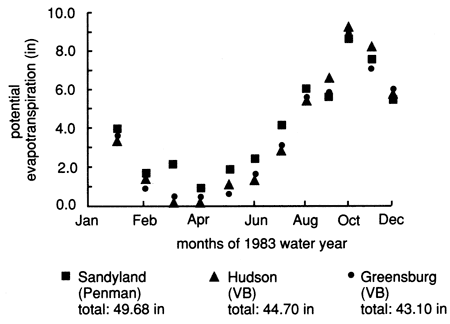
Finally, detailed weather data at the Sandyland station for 1982-83 were discovered in manual files at the station near the end of this study. These data provided an opportunity to compare the regression method for estimating potential evapotranspiration used in the VB procedure with the more elaborate Penman method. Figure 35 shows a comparison of monthly PE estimates using both methods. The PE patterns are similar with a tendency toward PE underestimation by the VB procedure during the winter months and overestimation during the summer months. The total water-year PE estimates range within 10-13% of each other (fig. 35), thus providing an excellent comparison given the bare-minimum nature of the input data for PE estimation used in the present study.
Figure 35--Comparison of potential-evapotranspiration estimates using Penman and Versatile Budget procedures.
Conclusions and Recommendations
The validity and performance of the VB procedure for providing sufficiently accurate estimates of daily soil moisture on a zone by zone basis and for other applications of relatively small scale (field plot, farm size) has been extensively covered in the literature. The performance of the budget in combination with the integration methodology presented here has been shown in this report to provide a suitable tool for regional estimates of various hydrologic variables from standard climatic, soil, and crop data for agricultural watersheds. We also demonstrated that because of the significant differences among irrigated and dryland croplands and grasslands, the spatial resolution of hydrologic variables within the watershed into these three categories, as adopted in the present study, is a simple, intuitive, and realistic approach. Also the VB procedure employed in this study is simple to understand and use. Thus, the objective of this study--to develop a sufficiently detailed and relatively simple hydrologic budget able to characterize the spatial distribution of the hydrologic components for the entire Rattlesnake watershed--has been achieved.
For the Rattlesnake watershed, precipitation was demonstrated to be the principal natural-water supply, while evapotranspiration is the major water-depletion process. These water-balance components dominate and control all other hydrologic variables such as runoff, deep drainage, and soil-moisture deficit. Compare, for example, the effect of precipitation on deep drainage, and the large difference in values of the ET component compared to the soil-moisture deficit, deep drainage, and runoff variables (fig. 23).
Soil factors, such as the available-water capacity of soil profiles, play a dominant role in soil-moisture-deficit development; the larger the AWC, the larger the resulting soil-moisture deficit, given appropriate and equal conditions (fig. 19). Soil factors also significantly affect deep drainage; the lower the AWC, the higher the deep drainage, everything else being equal (fig. 21).
Vegetation and land use (i.e. dryland or irrigated farming) play a significant role in the components of the water balance, especially in the ET process. Thus, evapotranspiration from irrigated-alfalfa acreages is approximately triple that from wheat-fallow fields, and ET amounts from cornfields are approximately double that from wheat-fallow acreages. ET from grasslands is almost 30% higher than that from dryland wheat-fallow fields. Most of the irrigation amounts for summer crops, such as sorghum and soybean, are spent in ET activities with negligible amounts for deep drainage. Deep drainage from irrigated wheat fields is significantly higher than from dryland wheat fields and minimal from alfalfa fields (fig. 27). Dryland wheat-soybean rotations and cornfields create significantly higher soil-moisture deficits compared to irrigated wheat-sorghum fields, assuming that farmers irrigate the appropriate amounts for each crop. Everything else being equal, the lowest runoff values occurred from prairie grasslands and alfalfa fields. We therefore conclude that the effects of vegetation and land use are too significant to be ignored, and therefore, more research efforts into the biological phase of water-balance computations are in order.
Ample room exists for improvements in the VB procedure, such as updating and improving the runoff function; providing a soil-water-movement rate aspect; incorporating surface slope and surface-water storage functions, interception storage, and free-water evaporation; accounting for depth to the water table; improving the snow budget, and so on. However, one should always strive not to lose one of the main advantages of the VB, namely, that it is easy to use and does not involve elaborate procedures. Although a purely physical approach is preferable, considerable research would be required to overcome the high spatial variability inherent in hydraulic-conductivity, root-water-consumption and root-distribution functions.
The methodology presented here can be used to predict the impact of human and natural activities on the hydrologic cycle. We showed, for example, that decreasing the acreages of alfalfa and corn (the high-water-consumption crops) and increasing the winter wheat acreages in the basin would result in significant increases in deep drainage and ground-water recharge. Thus, we have demonstrated how changes in cropping practices may influence components of the hydrologic cycle and how such an approach can be used as a demonstration and predictive tool with obvious management capabilities. However, more work is needed to assess the quantitative capabilities of the VB as a predictive tool on a watershed scale.
We showed that the south-central portion of the watershed produced the highest amounts of deep drainage while the northeastern portion produced the least amount. The highest runoff values were in the southwestern portion of the watershed, while the lowest runoff amounts were produced in the northeastern portion of the watershed. Thus, it may be readily recognized that single average values of hydrologic variables used in management practices may not be realistic and that some spatial distribution or zonation in managing water resources is in order.
Because of the dynamic nature of the hydrologic system, the results presented herein are not permanent and may change with land-use practices, vegetation changes, and especially hydroclimatic factors. Data were presented in this report indicating the magnitude of such changes to be expected. Also note that the results and conclusions presented here are specifically for the 1983 water year, and although the presented patterns are believed representative of the watershed, care must be taken in extrapolating and overgeneralizing the results without due consideration to the dynamic nature of the water balance in the area.
Acknowledgments
Dr. Johanne Boisvert of Agriculture Canada kindly provided the VB program on tape and other requested information, as well as reviewed the manuscript. Dr. Buck Sisson, formerly of Kansas State University, also provided a useful review of the text. Ralph Davis, former manager of the Big Bend Groundwater Management District No. 5 provided useful insights for this study, in addition to reviewing the text. Several colleagues at the Kansas Geological Survey reviewed earlier versions of this report, among them Jamshid Sadeghipour, Jim Butler, Jerry Welch, and Margaret Townsend. Nadeem Shaukat and Geoff Coble, former student assistants at the Kansas Geological Survey, assisted with data-handling problems during the course of this study. Two anonymous reviewers of a summary extract of this report, which appeared in the Water Resources Bulletin, v. 23, no. 6, p. 997-1,010 (1987), provided useful reviews. Jennifer Sims, Gina Ross, and Renate Hensiek, all at the Kansas Geological Survey, produced the graphics for this report. Marla Adkins-Heljeson edited the report.
Prev Page--Implementation, Results || Next Page--References
Kansas Geological Survey, Geohydrology
Placed on web Aug. 16, 2010; originally published 1990.
Comments to webadmin@kgs.ku.edu
The URL for this page is http://www.kgs.ku.edu/Publications/Bulletins/GW11/06_conc.html