![]()
Prev Page--Introduction || Next Page--Approach and Versatile soil moisture budget
Watershed Hydrogeologic Environment
Physiography and Drainage
The Rattlesnake watershed is located in two physiographic regions. The upper ~85% of the watershed is located in the Arkansas River lowlands (Great Bend region); it is a relatively flat alluvial plain characterized by sand-dune topography with moderate slopes and small hills separated by small basins (Latta, 1950). The lower 15% of the watershed belongs to the High Plains region, which also is a comparatively flat alluvial plain dissected by intermittent streams and exhibiting shallow depressions and gentle swells. Much of the sand-dune area of the watershed is covered by vegetation, and a large part of it is farmed; the watershed is primarily agricultural.
Of the approximately 1,455 mi2 (3,768 km2) contained in the Rattlesnake Creek watershed, approximately 780 mi2 (2,028 km2) are not contributing to surface runoff (fig. 4). The Rattlesnake watershed boundary was constructed based on the highest regional-topographic relief estimated from 7 1/2-min U.S. Geological Survey quadrangle maps which cover the watershed, in combination with Kansas State Highway Commission general highway maps of counties depicting surface-drainage features.
Figure 4--Surface-drainage map and weather stations of Rattlesnake watershed.
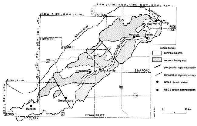
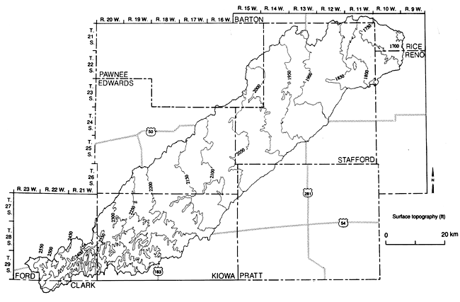
The watershed is drained by Rattlesnake Creek, which is a meandering stream flowing from the High Plains area northeasterly into the Great Bend lowlands area where it empties into the Arkansas River (fig. 4). The creek originates in three tributary forks located in southeastern Ford and northwest and north-central Kiowa counties. The three forks join in north-central Kiowa County to form the main stream of the creek; it then flows through the remainder of Kiowa County, through Edwards County, across extreme northwest Pratt County, through Stafford County, and into the southwestern comer of Rice County where it empties into the Arkansas River, approximately 6 mi (10 km) southeast of Raymond, Kansas. The channel slopes about 33 ft/mi (6.3 m/km) for the first 6 mi (10 km) from its source in the southeast corner of Ford County; then it flattens to a slope of about 7 ft/mi (1.3 m/km) up to St. John, and 4 ft/mi (0.8 m/km) below St. John, as can be inferred from the surface-topography map in fig. 5.
Figure 5--Surface topography of Rattlesnake watershed.
Wetlands contributing to the creek consist of some 60,200 acres (24,360 ha) (Ray and Coslett, 1972), most of which have high water tables, excessive mineral concentrations, and drainage problems. A portion of these wetlands are located in northeastern Stafford County and are contained within the boundaries of the Quivira National Wildlife Refuge, which is a major migratory waterfowl refuge in the central flyway. This refuge encloses approximately 33 mi2 (85 km2) of which the highly saline Big Salt Marsh comprises approximately 16 mi2 (41 km2). These marshes, which are located on the water table, are broad shallow expanses of water, heavily vegetated around the shoreline with a variety of prairie grasses. Rattlesnake Creek usually is a perennial stream from a point a few miles downstream from St. John to where it turns north near Little Salt Marsh; elsewhere it is intermittent. The valley of Rattlesnake Creek ranges from less than 0.5 mi (0.8 km) to about 2 mi (3.2 km) in width. Average flow of the Rattlesnake Creek at its mouth is about 24 cfs (0.68 m3/sec).
Three U.S. Geological Survey surface-water gaging stations are located in the watershed, one 8 mi (13 km) south of Macksville with a period of record since 1959; another upstream from Little Salt Marsh, 10 mi (16 km) north of Zenith, with a period of record since 1973; and a third station 3.5 mi (6 km) south of Raymond with a period of record since 1960 (fig. 4).
Hydrogeology, Pleistocene Drainage History, and Water Quality
The Rattlesnake Creek drainage area is composed, for the most part, of unconsolidated deposits of clay, silt, sand, and gravel of Pleistocene age, which overlie the eroded surface of Cretaceous- and Permian-age rocks. The unconsolidated materials are composed of undifferentiated early Pleistocene sediments (Meade formation) and late Pleistocene sediments (Sanborn formation; Latta, 1950). The state geological map describes the Rattlesnake Creek drainage watershed as dune sand with a small area of loess in the headwater area and a thin strip of alluvium adjacent to Rattlesnake Creek (Geologic Map of Kansas, 1964).
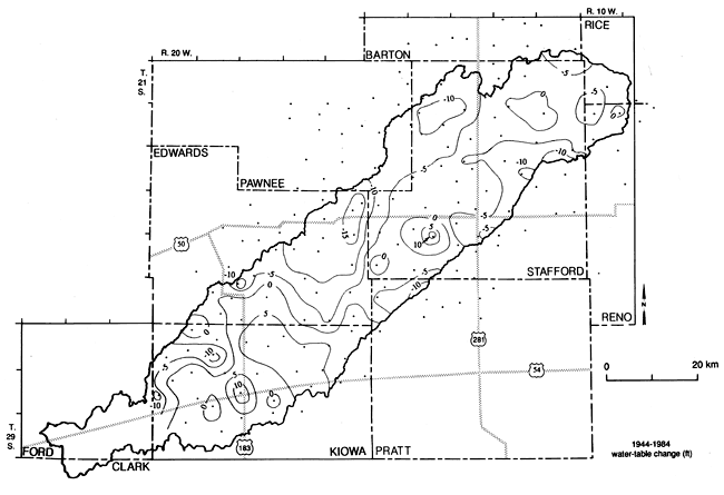
The 1984 water-table contours in the watershed (fig. 6) indicate a general eastward and northeastward ground-water flow direction. The depth to the water table is shallow, of the order of 10-20 ft (3-6 m), in the northeastern portion of the watershed; however, it progressively deepens to the southwest, reaching depths of more than 100 ft (30 m) in Kiowa County (fig. 7). The effects of the large ground-water-based irrigation development in the area can be seen in the 1940-1984 water-table-change map (fig. 8). The largest water-level declines in the watershed occurred mainly in northeast Edwards and northwest Stafford counties, where the largest irrigation development occurred.
Figure 6--1984 Water-table map of Rattlesnake watershed.
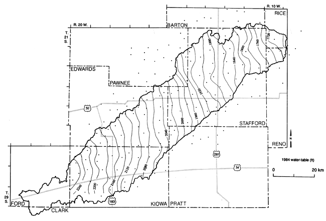
Figure 7--1984 Depth-to-water-table map of Rattlesnake watershed.
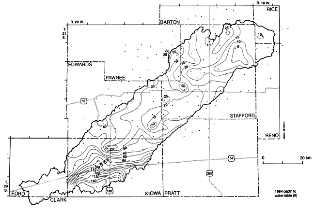
Figure 8--1944-1984 Water-table-change map of Rattlesnake watershed.
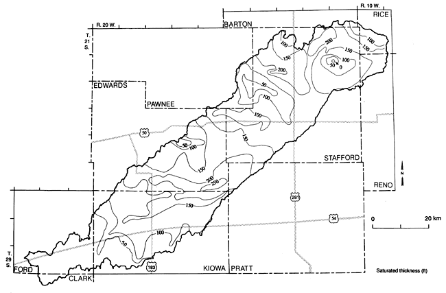
The nature of the unconsolidated deposits permits high rates of infiltration and conversely low rates of storm-water runoff. The deposits extend to variable depths. Accordingly, the depth of saturated water-bearing materials also varies, as shown by the saturated-thickness map (fig. 9). The water table described in figs. 6 and 7 is relatively shallow, and wells yielding 1,000 gal/min (3,800 L/min) are common in the watershed. Latta (1950) has produced a number of typical cross sections that define the underlying aquifer.
Figure 9--Saturated-thickness map of the Rattlesnake watershed.
Rattlesnake Creek can be considered as the drain, or the overflow spillway, from the underground aquifer (Strammel, 1967). As a result, Rattlesnake Creek has been for the most part a perennial stream from a point a few miles downstream from St. John, Kansas, to where it turns north near the Little Salt Marsh.
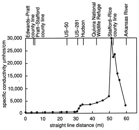
The Permian bedrock subcrops in a north-south trend in the vicinity of US-281 (fig. 10). For the most part, these deposits contain no important aquifers. However they are significant hydraulically in that they are a source of poor quality water, especially the Late Permian "red beds." This poor quality water rises upward and increases the water salinity of the unconsolidated aquifer in the lower reaches of Rattlesnake Creek-in particular, the Quivira Wildlife Refuge area. The mechanical details of the subsurface hydraulic relationships of the consolidated and unconsolidated deposits are not clearly understood. The average chloride load of flow in Rattlesnake Creek at its mouth is about 130 tons/day (118 metric tons/day; U.S. Army Corps of Engineers, 1973). The water in the vicinity of the salt marshes is believed to be a natural occurrence of artesian saltwaters encountered deeper to the west. Here the water flows from the edges of the bedrock formation into the overlying sediments and rises to the surface in the low areas, primarily along Rattlesnake Creek. The upper reaches of Rattlesnake Creek yield fairly good quality water with very little chloride pollution from natural sources. An electrical-conductivity survey (Bindleman, 1983) of Rattlesnake Creek during 1983 (fig. 11) indicates that conductivity from eastern Edwards County to just northeast of St. John ranged from 350 µmhos/cm to approximately 625 µmhos/cm. An abrupt rise in conductivity was observed within a 3-mi (5-km) distance 1 mi (1.6 km) east of where Rattlesnake Creek crosses US-281, with values leveling off at 3,000-4,000 µmhos/cm. Where the creek enters the Quivira National Wildlife Refuge, another rise in conductivity occurs with an abrupt increase to values exceeding 20,000 µmhos/cm within a 2-mi (3-km) stretch (fig. 11). Before discharging into the Arkansas River, however, the creek's conductivity drops to 3,141 µmhos/cm. Most of the pollution is from small seeps or marshes in and near the streambed.
Figure 10--Bedrock map of the Rattlesnake watershed.
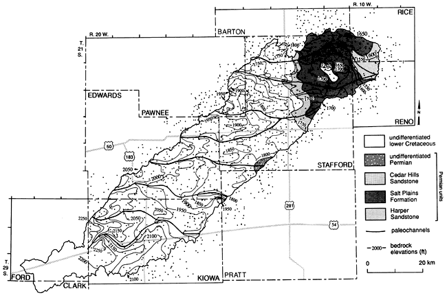
Figure 11--Specific conductance survey along Rattlesnake Creek (adapted from Bindleman, 1983).
The present drainage system of the watershed, and of central Kansas, in general is the result of events that took place during the Pleistocene Period. The Pleistocene history of the area is very complex and is marked by the cutting and filling of deep valleys and by major changes in drainage (Frye and Leonard, 1952; Fent, 1950). During early Pleistocene time, the ancestral Arkansas River, instead of following the present course around the "great bend," is thought to have flowed eastward or southeastward across south-central Kansas. This can be seen in the bedrock map (fig. 9), where a number of west-east paleodrainage channels can be seen progressing from south to north throughout the watershed.
The Pleistocene drainage patterns of central Kansas record the history of the northeastward migration of through-flowing streams from the Rocky Mountain area. According to Fent (1950), this migration probably was caused by successive captures of the southern trunk stream by its own northern tributaries. The captures seem to result from the difference in the debris load available in the headwater areas of the streams. Through-flowing streams originating from the Rocky Mountains, such as the Arkansas River, have filled their channels throughout Pleistocene time with coarse igneous-type gravel and sandy alluvium. This material accrued on the surface over which they flowed, causing stream avulsions and the consequent spreading of alluvial material over wide areas. In contrast, the northern tributaries to the southern trunk stream carried only the finer grained, less-permeable sediment load obtained by downcutting in their immediate headwater areas. The silt and fine sand of local origin at the northern Great Bend Prairie, with its low permeability, favored runoff and consequently more erosion and downcutting below the level of the through-flowing streams; this downcutting led to the eventual capture of the through-flowing streams. This is evident in the relative abundance of northern tributaries to the Arkansas River in central Kansas (Fent, 1950).
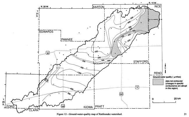
The overall ground-water quality of the Rattlesnake watershed, as indicated by the specific conductance of ground-water samples collected during the 1980-85 period, is presented in fig. 12. It can be seen that the northeastern portion of the watershed, especially along the Rattlesnake Creek and the marsh areas, exhibits high specific conductance values, indicating saltwater intrusion from the Permian formations into the alluvial aquifer. The best ground-water quality, as indicated by the lowest specific conductance values, is located in the south-central portion of the watershed (fig. 12). It is interesting to note that, in general, the better ground-water quality is usually observed in the inferred bedrock channels, while the poorer ground-water quality is observed at locations overlying the bedrock ridges separating the buried channels. Thus, for example, the poorer ground-water quality indicated by the 600 µmhos/cm contour in a west-to-east direction in the central portion of the watershed (fig. 12) coincides with a bedrock ridge in that location (fig. 10); the same is true with the 500 µmhos/cm contour in the southwest portion of the watershed. In contrast, the best quality ground water is observed in the south-central portion of the watershed, where a number of paleochannels converge into a larger one (fig. 10). It is interesting to note that this area also coincides with the soils of higher permeability (fig. 14) and higher recharge portion of the watershed as will be shown later. Also, especially at the south side of the ridge outlined by the 600 µmhos/cm contour in the central portion of the watershed, there appears to be a better quality water in that channel despite its crossing a Permian outcrop at the eastern crossing of the watershed boundary (fig. 10). Similar observations also are expressed in Hathaway et al. (1978).
Figure 12--Ground-water-quality map of Rattlesnake watershed.
Soils
The soils of the watershed can be placed into two broad categories (Hathaway et al., 1978): deep silty soils of the upland areas (High Plains region) and loamy and sandy soils of the Great Bend region. Most of the upland soils are well drained, while the sandy soils of the Arkansas River lowlands vary from well drained to poorly drained. A generalized soil-association map of the watershed (fig. 13) has been produced through a combination and regrouping of Soil Conservation Service soil-survey data available for individual counties.
Figure 13--Soil-association map of Rattlesnake watershed.
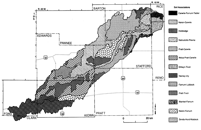
The soils of the watershed formed in several different kinds and ages of parent material, such as sand, loess, and Pleistocene and Holocene sediments.
In early Pleistocene time, alluvium (Meade formation) was deposited over most of the watershed. Soils formed in this old wind-modified alluvium include the Farnum, Blanket, and Lubbock soils (Roth, 1973). Carwile soils also formed in old alluvium.
The loess deposits consist of relatively sand-free silty material that was deposited by wind in late Pleistocene time. The dominant soils formed in this parent material are the Harney, Holdrege, and Uly soils.
Eolian material with high sand content is the major parent material of the soils in the sandhills. Most of this material was deposited during the Holocene, after the Pleistocene loess was deposited (Roth, 1973). Tivoli soils formed in fine sand, Attica and Pratt soils in loamy fine sand, and Naron soils in fine sandy loam. Tivoli and Pratt soils occur in areas of undulating to dunelike topography. Attica, Naron, and Pratt soils occur in areas of nearly level to undulating topography next to sand-dune areas.
The alluvium that was deposited in the Holocene time is variable, ranging from sand to clay loam. The dominant soils in this parent material are the Hord and Zenda soils, as well as soils of the Natrustolls-Plevna association. The Natrustolls and Plevna soils were formed on floodplains and stream terraces along the Rattlesnake Creek and the Big and Little Salt Marsh areas.
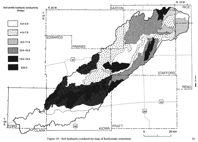
Soil-profile permeability compilations (down to ~60 inches [~1.5 m]) from the Soil Conservation Service county soil-survey reports are depicted in fig. 14. The higher permeability, and therefore higher infiltration, regions are clearly indicated. The individual soil permeabilities for all soil-profile depths and all soils composing a soil association were proportionally averaged. This hydraulic conductivity map should be interpreted cautiously because of the averaging procedure. Thus, for example, a low-permeability layer in the soil profile will control vertical water movement despite the presence of highly permeable layers above and below. Also, an average value of each soil series is used irrespective of its areal or depth location within the soil profile.
Figure 14--Soil hydraulic-conductivity map of Rattlesnake watershed.
Climate
The climate of the Rattlesnake drainage watershed is characterized by low precipitation, rapid evaporation, and a wide range of temperatures. The mean annual precipitation ranges from approximately 20 inches (50 cm) in Ford County to 26 inches (65 cm) in Rice County. The "effective" precipitation is considerably less than the average annual rainfall (Brown, 1973). A number of light showers occur, and much of this moisture evaporates from the soil with little or no benefit to growing crops. At the other extreme, occasional heavy downpours in spring, summer, and fall cause appreciable runoff from cultivated fields.
Lack of moisture is the most frequent limiting factor in the production of crops on dryland farms in the watershed. Summer fallowing, which minimizes the effects of deficient rainfall, is a common practice. Significantly, approximately 75% of the precipitation falls during the growing season of April through September.
Two regional climate controls, the Rocky Mountains and the Gulf of Mexico, contribute to the precipitation pattern in the watershed. The Rocky Mountains are effective in producing a "rain shadow" over western Kansas. The Gulf of Mexico is the principal source of moisture for precipitation in the area. Most of the total annual precipitation comes from convective shower activity (Bark, 1978). Thunderstorms move across the watershed usually in the evening or at night. Rainfall is most common from 7:00 p.m. to 3:00 a.m. Forty percent of the hours that have rainfall during the 24-hr day occur between midnight and 6:00 a.m. Only 35% of the hours with rainfall occur during the peak outdoor work period of 6:00 a.m. to 6:00 p.m. (Bark, 1978).
Winters, although cold, are generally not severe, and snowfall is light with less than 20 inches (50 cm) of total snowfall over the winter months (October to March). The mean annual temperature is approximately 55°F (13°C) in the watershed and ranges from winter lows of below -10°F (-23°C) to summer highs above 105°F (41°C).
Summer humidity in the region usually is low and annual surface-water evaporation ranges from 50 to 85 inches (125-213 cm) with an average of approximately 60 inches (150 cm). Wind velocities are commonly high, averaging from 12 to 15 mi (19-24 km) per hour. The months of March through June are the windiest months. Occasionally high winter-wind velocities, accompanied by a typical snowfall deposition, may produce blizzard conditions.
Drought conditions have prevailed in the watershed for extensive periods of time. Perhaps the most extensive and notable period was the "Dirty Thirties," when very low amounts of annual rainfall were received and high winds created a multitude of dust storms. Drought periods of three to four years duration are typical in the watershed (Ray and Coslett, 1972), and perhaps one of the most severe recent droughts occurred from 1964 to 1967. During 1966, only 14.00 inches (35.56 cm; 6.88 inches [17.47 cm] below normal) were received in Bucklin, 13.46 inches (34.19 cm) in Greensburg (8.47 inches [21.51 cm] below normal), 17.32 inches (43.99 cm) at Hudson (6.77 inches [17.20 cm] below normal), and at Trousdale, in Edwards County, a new record low of 9.29 inches (23.60 cm; 12.92 inches [32.81 cm] below normal) was recorded.
Prev Page--Introduction || Next Page--Approach and Versatile soil moisture budget
Kansas Geological Survey, Geohydrology
Placed on web Aug. 16, 2010; originally published 1990.
Comments to webadmin@kgs.ku.edu
The URL for this page is http://www.kgs.ku.edu/Publications/Bulletins/GW11/03_envir.html