![]()
Prev Page--Stratigraphy--Tertiary || Next Page--Structural Geology
Stratigraphy, continued
Quaternary Formations
The Quaternary deposits of southwestern Kansas are the thickest and most extensive yet discovered in the central High Plains. They occur mainly in Meade and Clark counties, and, for the most part, have not heretofore been differentiated from the Ogallala. Although widespread, their relations are as yet by no means entirely clear. Exposures are discontinuous, covered areas are broad, lateral changes in depositional facies seem to be common, and sedimentation has been controlled in part by local conditions lacking any broad areal significance. Consequently there are difficulties in correlating different sections of the same deposits, and in determining the relative age of different deposits. Lithologic similarities, for the most part, constitute the only available means of correlation, and are supplemented in some instances by physiographic relations. Age determinations are based principally on the evidence of vertebrate fossils. Although numerous vertebrate faunas have been discovered, many of these are lacking in the diagnostic forms required for exact dating, and therefore fail to give complete certainty. Invertebrate faunas, although very common, have thus far given little promise as aids in determining age relations. Until more numerous and more extensive vertebrate faunas are discovered, many questions will probably remain unanswered. The following description is to be regarded only as a progress report; much remains to be learned not only from paleontological studies, but also from detailed areal mapping and from test drilling.
Only two of the Pleistocene deposits in the area seem thus far to be sufficiently distinctive and sufficiently continuous to justify the application of formation names: the Odee, of earlier Pleistocene age, and the Kingsdown; of later Pleistocene age. Other deposits of smaller extent and of less certain relations are designated simply by provisional lithologic, faunal, or locality names. These include the "Equus niobrarensis beds", the "Jones Ranch beds", volcanic ash, loess, terrace deposits, dune sand, and alluvium. These several deposits and formations are described in the order of their relative ages as tentatively outlined, and the adequacy of the evidence for such age assignments is discussed in connection with each.
Odee Formation
General Character
The Odee formation, here described and distinguished for the first time, is named from typical outcrops in Odee township, in southern Meade County. It consists predominantly of fine-grained material, being composed principally of silt and clay, or of their indurated equivalents. Numerous thin beds of fine sand are present, some locally cemented to form a hard rock, and fewer beds of coarser sand and gravel. A single bed of diatomaceous marl was found. Calcareous nodules are found in some beds, and selenite crystals are common in many parts of the formation. The characteristic color of the formation is dark, reddish brown to deep red, very similar to that found in some of the redbeds of the Permian, with which, in fact, some parts of the formation may easily be confused. A few of the beds show other colors, ranging from gray through greenish to buff, chocolate, and rusty brown. The maximum exposed thickness of the formation is about 300 feet. The formation as a whole seems to represent an alluvial or lacustrine fill in an irregular basin, partly erosional, partly deformational, in the Ogallala. It is best exposed along the Cimarron valley in southern Meade County and in northern Beaver County in Oklahoma. Smaller and more scattered exposures are found also along Crooked creek and its tributaries, and along Little Sandy creek in western Clark County. In many exposures the beds are more or less deformed, dipping as much as 25°. The formation is comparatively soft and easily eroded, forming sharp, steep-sided gulches bearing sparse vegetation.
Areal Description
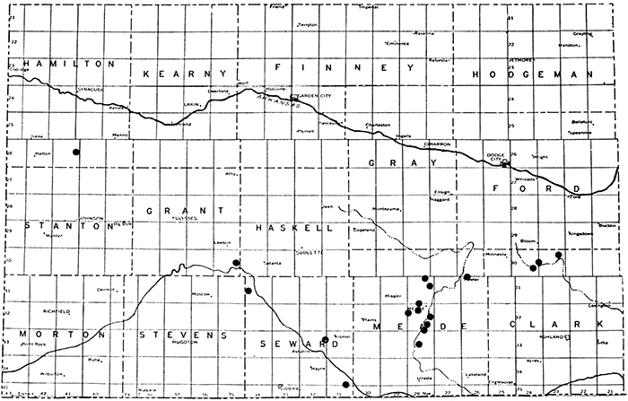
Outcrop areas and inferred minimum extent of the Odee formation are shown in figure 11. Typical is the section exposed at locality A, along a short tributary gulch on the north side of the Cimarron valley on the XI ranch in the W2 sec. 35, T. 34 S., R. 29 W. The beds are essentially horizontal and undisturbed. The base is concealed.
Figure 11--Sketch map showing distribution of the Odee formation. Outcrop areas are shown in solid black, and the inferred extension under cover is shown by the ruled pattern.
| Section of the Odee formation in sec. 35, T. 34 S., R. 29 W., Meade County, Kansas | Thickness in feet |
||
|---|---|---|---|
| Quaternary system | |||
| Soil | 3 | ||
| Odee formation | |||
| 8. Sand, structureless, buff-colored, fine-grained, containing caliche nodules | 8 | ||
| 7. Mudstone, red | 8 | ||
| 6. Silt, buff-colored, containing some red clay bands | 4 | ||
| 5. Mudstone, red, containing one thin layer of buff silt; a few invertebrates at top | 17 | ||
| 4, Silt and sand beds, gray to buff, containing some interbedded reddish clay; contains invertebrates | 6 to 7 | ||
| 3. Mudstone, reddish-brown | 13 | ||
| 2. Sand and silt, buff-colored, fine | 2 | ||
| 1. Mudstone, red, containing a few layers of sand and silt | 35 | ||
| Total exposed thickness of Odee formation | 94 feet | ||
Two miles west of the above section, at locality B, another section is exposed along a similar tributary gulch. The formation here, however, is considerably distorted, contains local unconformities, and is not quite continuously exposed. Although no complete section is readily measurable, the upper part of the section is approximately as follows:
| Section of the Odee formation in sec. 33, T. 34 S., R. 29 W., Meade County, Kansas | Thickness in feet |
|
|---|---|---|
| Quaternary system, Odee formation | ||
| 7. Mudstone, light greenish-gray, containing some selenite | 6 | |
| 6. Sand, gray to brownish, fine | 11 | |
| 5. Sand, silty, brownish, calcareous, containing invertebrates | 1 | |
| 4. Sand, silty, fine, soft, gray, containing invertebrates | 3 | |
| 3. Sand, hard, gray, calcareous | 2 | |
| 2. Sand, clayey, gray, mottled with rusty spots | 0 to 2 | |
| 1. Sand, reddish, massive to medium-bedded | 20± | |
This section is underlain by 75 to 100 feet of sand containing some gravelly beds, in part cross-bedded, and ranging from gray through rusty to reddish. No basal contact was found. Fossil remains of Aenocyon dirus (Leidy) were identified by Hibbard (1939) from bed No. 4 (?) and Castor sp. from bed No. 6. Associated with the former were the following invertebrates, identified by F. C. Baker.
| Invertebrate fauna of the Odee formation in sec. 33, T. 34 S., R. 29 W. | |
|---|---|
| Fresh-water species: | |
| Sphaerium sp. | |
| Stagnicola sp. | |
| Terrestrial species: | |
| Succinea grosvenori Lea | |
| Pupoides marginatus (Say) | |
| Pupilla blandi obtusa Cockerell | |
| Gastrocopta cristata Pilsbry and Vanatta | |
| Gastrocopta cristata var. Pilsbry and Vanatta | |
The westernmost exposure of the Odee observed by me is on the west side of the county road crossing the Cimarron valley south of Plains, in sec. 2, T. 35 S., R. 30 W. The exposed thickness is about 15 feet. The outcrop is about 100 feet above river level and about 140 feet below the Ogallala ledges at the edge of the upland.
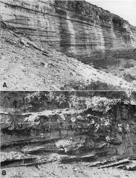
At locality C, about 7 miles southeast of section A, also on the north side of the Cimarron valley (sec. 10, T. 6 N., R. 25 E., Oklahoma) , the following section is exposed (pl. 14A) :
| Section of the Odee formation in sec. 10, T. 6 N., R. 25 E., Oklahoma | Thickness in feet |
||
|---|---|---|---|
| Quaternary system | |||
| Soil | 3 | ||
| Odee formation | |||
| 13. Sand, light-buff, red clay at base | 11 | ||
| 12. Sand and medium gravel, gray, grading upward into very rusty sand; gray sand, containing a few invertebrates, at top | 12 | ||
| Unconformity | |||
| 11. Mudstone, brownish, including a few gray streaks | 16 | ||
| 10. Silt, thin-bedded, light-buff | 1.5 | ||
| 9. Mudstone, red | 3.5 | ||
| 8. Sand and silt, grayish, containing a few invertebrates | 1 | ||
| 7. Mudstone, brownish, including a few silt layers | 9 | ||
| 6. Sand, brown, containing fine pebbles | 1 | ||
| 5. Mudstone, brownish | 15 | ||
| 4. Silt beds, light-buff, alternating with darker mudstone beds | 4 | ||
| 3. Mudstone, brownish | 15 | ||
| 2. Mudstone, reddish, alternating with grayish sand and silt | 6 | ||
| 1. Mudstone, reddish | 12 | ||
| Total exposed thickness of Odee formation | 107 feet | ||
The lower part of the section is very gypsiferous in places. The base is not exposed. Dips are uniformly eastward, and are as steep as 24°.
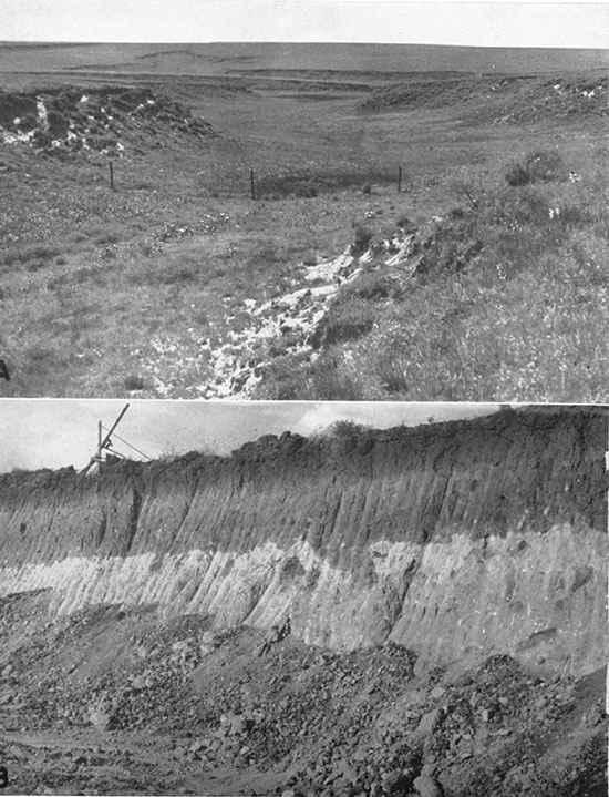
Plate 14--Characteristic exposures of the Odee formation. A, Along the Cimarron valley, about 21 miles south of Meade. B, Along Shorts creek, in the southwestern corner of T. 33 S., R. 29 W. Note the minor fault.
Just southeast of the above exposure, in section 15 of the same township (locality D), a still thicker section of the Odee is exposed in an old, dissected sink. All except the uppermost beds are irregularly deformed, seemingly by the collapse involved in the formation of the sink. Dips are as steep as 27°. Making due allowance for the irregularities of dip, the following approximate thicknesses were measured.
| Section of the Odee formation in sec. 15, T. 6 N., R. 25 E., Oklahoma | Thickness in feet |
||
|---|---|---|---|
| Quaternary system | |||
| 21. Sand, finely laminated, dirty brown, silty | 20 | ||
| 20. Clay, silty, dark-gray | 5 | ||
| 19. Sand, silty, light greenish-gray, calcareous | 12± | ||
| Angular Unconformity | |||
| Odee formation | |||
| 18. Mudstone, soft, chocolate-colored | 15± | ||
| 17. Mudstone, greenish | 1 | ||
| 16, Mudstone, massive, chocolate-colored | 17 | ||
| 15. Marl, diatomaceous to sandy, gray to white, contains fossils | 4 to 16 | ||
| 14. Sand, soft, fine- to medium-grained, buff-colored | 10± | ||
| 13. Mudstone, chocolate-colored, including greenish lens at base; contains some invertebrates | 4 | ||
| 12. Sandstone, soft, thin-bedded, fine-grained, brownish | 2 | ||
| 11. Clay and sand beds, gray to brownish | 3 | ||
| 10. Sand, fine-grained, and silt, thin- and even-bedded, gray to yellowish, channel filling | 2 to 8 | ||
| 9, Mudstone, massive, chocolate-colored | 0 to 4 | ||
| 8. Mudstone, chocolate-colored, and some buff sand | 8± | ||
| 7. Covered interval | 50± | ||
| 6. Sand, gravelly, yellowish to buff | 9 | ||
| 5. Mudstone, gray to brownish-gray, sandy, contains some invertebrates | 20 | ||
| 4. Sand, gravelly, yellowish to rusty | 18 | ||
| 3, Sand, fine, yellowish-brown, contains a few invertebrates | 6 | ||
| 2. Sand, loose gravelly | 5 | ||
| 1. Mudstone, massive, reddish-brown, gypsiferous toward top | 120± | ||
| Total exposed thickness of Odee formation | 309 ± feet. | ||
The beds above the unconformity in this section are essentially horizontal, and represent a fill deposited after the formation of the sink, and are therefore somewhat younger than the Odee. At least in part, they are probably lacustrine. Sinks similar to this one, but undissected, are numerous in the southern part of the Meade quadrangle, and some contain temporary lakes. In the true Odee at this locality, vertebrate fossils have been found in one zone, bed No. 15. This bed yielded remains of Archidiskodon imperator (Leidy), Synaptomys bunkeri Hibbard (1940), a duck of the family Anatidae, and fragmentary fish and amphibian material as yet unidentified. Associated with the vertebrates was the following invertebrate fauna, studied by F. C. Baker:
| Invertebrate fauna of the Odee formation in sec. 15, T. 6 N., R. 25 E., Oklahoma | |
|---|---|
| Fresh-water species: | |
| Stagnicola caperata (Say), rare | |
| Gyraulus altissimus (F, C. Baker), common | |
| Physa anatina (Lea), very abundant | |
| Physa hawnii (Lea), very abundant | |
| Helisoma trivolvis lentum (Say), very abundant | |
| Terrestrial species | |
| Succinea grosvenori Lea | |
The Physa were identified by W. J. Clench. The lower part of the section described above is essentially similar to the section at locality C, which, in fact, dips into or under the dissected sink.
North of the Cimarron valley, the Odee is probably widespread, but is mostly covered, and is represented by fewer and smaller exposures. Of these, the best that I found are those along Shorts creek, in sec. 36, T. 33 S., R. 29 W., Meade County, and in the adjoining part of the section to the east. In this locality, gray-green and reddish mudstone are interbedded, and seem to grade laterally into one another. Large, well-developed selenite twins are abundant in the redbeds at many places. The beds dip at low angles to the east, and are cut by a few minor faults (pl. 14B). Invertebrates are common, and bones of a small Pleistocene camel were collected by Hibbard about 25 feet above stream level near the township corner. The following invertebrates associated with this fossil were identified by F. C. Baker:
| Invertebrate fauna of the Odee formation in sec. 36, T. 33. S., R. 29 W., Kansas | |
|---|---|
| Fresh-water species: | |
| Pisidium sp. | |
| Stagnicola caperata Say | |
| Fossaria parva (Lea) | |
| Helisoma trivolvis lentum (Say) | |
| Gyraulus altissimus (F. C. Baker) | |
| Physa anatina (Lea) | |
| Terrestrial species | |
| Succinea grosvenori Lea | |
| Pupilla blandi Binney | |
| Vertigo ovata Say | |
| Vallonia gracilicosta Reinhardt | |
A few miles southwest of the above locality, probably in the SE sec. 3, T. 34 S., R. 29 W., Haworth (1897b, p. 274) reports that a well 288 feet deep passed "through nothing but clay, until almost the total depth was reached." This suggests that the well was drilled mainly in Odee, perhaps penetrating some Rexroad beds below.
On the east side of Crooked creek 8 miles south of Meade (sec. 21, T. 33 S., R. 28 W.), the Ogallala is overlain by about 30 feet of greenish-gray calcareous clayey sand to sandy mudstone, containing a lenticular bed of volcanic ash 8 feet above the base (see section, p. 66). On the basis of similarity to the greenish beds of the Shorts creek section, and dissimilarity to beds associated with other deposits of volcanic ash in Meade County, this section is provisionally interpreted as a non-red facies of the Odee formation. Physiographic relations accord with this correlation, for the beds crop out at the eroded edge of a nearly flat upland surface, which lies at the same level as, and seems once to have been continuous with the surface at the top of the Odee along the Cimarron valley. This surface seems best explained as of depositional origin. It has since been modified by erosion, and, on the west side of Crooked creek, seemingly also by downwarping.
Along a short tributary on the south side of Crooked creek 16 miles south and 5 miles east of Meade (secs. 27 and 34, T. 34 S., R. 27 W.), discontinuous exposures of distorted greenish and reddish sandy and clayey beds bear a strong resemblance to the Odee beds, and occur at a bout the same topographic level as the Odee beds of localities C and D in the Cimarron valley.
Along Little Sandy creek in western Clark County, about 5 miles west of Ashland (sec. 18, T. 33 S., R. 23 W.), the eastern-most outlier of probable Odee was found. The following section is exposed in a steep, undercut bluff on the west side of the creek.
| Section of the Odee formation in sec. 18, T. 33 S., R. 23 W., west of Ashland, Clark County, Kansas | Thickness in feet |
|
|---|---|---|
| Quaternary system, Odee formation | ||
| 5. Sand and silt, soft, even-bedded, reddish-brown, some grit and pebble layers, and a few greenish bands | 35 | |
| 4. Mudstone, thinly laminated, gray to chocolate | 8 | |
| 3. Grit, structureless, reddish, containing a few invertebrates | 4 | |
| 2. Sand, light-buff to rusty-colored, even-bedded | 6 | |
| 1. Mudstone, massive, red | 5+ | |
| Total exposed thickness of Odee formation | 58 feet. | |
A few minor faults cut the lower part of the section and bed No. 4 shows intricately contorted minor folds, somewhat similar to those produced experimentally by Rettger (1935) by differential loading. Bed No. 1 is lithologically identical with typical Odee, and beds 2 to 4 are similar. Division No. 5, however, is less typical, and may represent a younger deposit. It is probable that this deposit of Odee was formed in a valley or basin other than that of Meade County, but at the same time and under the same conditions. It is possible that equivalent deposits may be widely distributed in the Ashland basin, although additional exposures were not located during my rapid reconnaissance.
Age of the Formation
The few vertebrate fossils found in the Odee beds all indicate a Pleistocene age, and, with one possible exception, all were in the upper part of the formation. The elephant, Archidiskodon imperator, has been found in Kansan, Yarmouth, and Iowan deposits in Nebraska, and probably it occurs also in the Aftonian (Schultz, 1934, table A). Its presence in the Odee formation, although not diagnostic, is at least consistent with the postulate of early Pleistocene age suggested by the thickness, upland position, degree of dissection, and probable immediate superposition of the formation on the Rexroad. Future more detailed studies may well lead to subdivision of the Odee and the establishment of age differences within the formation.
Origin of the Formation
Many questions as to the origin of the Odee formation must await adequate knowledge of its distribution and lateral variations, particularly in Beaver County, Oklahoma. Working hypotheses suggested by the available facts, however, are outlined below.
The color and lithology of the greater part of the Odee deposits contrast sharply with those of the Ogallala, suggesting a different source of material. The prevailing reddish colors, although conceivably a result of climatic control, seem best explained as due to derivation from the erosion and reworking of Permian or Triassic redbeds. The direction and distance of the source area or areas remain to be ascertained. The gravel and coarser sand beds in the formation, however, are such as might have been derived from reworking of Ogallala materials.
The uniform stratification and lithology of the formation indicate deposition under relatively stable conditions, such as might have existed along the flood-plain of a sluggish, aggrading river. The invertebrate faunas studied by F. C. Baker are interpreted as representing a shallow-water, river habitat, into which some land snails were washed. It is probable that lacustrine conditions prevailed at least locally and temporarily, however, as indicated by the diatomaceous marl bed at locality D, and it is entirely possible that lacustrine conditions may have been general during the deposition of a part of the formation.
The association of the Odee formation with the present Cimarron valley suggests that the ancestral Cimarron may have played a part in depositing the formation. The facts at hand are insufficient to warrant any attempt to reconstruct the drainage conditions of that time, however, and it is entirely possible that the Cimarron had not yet taken its present course.
The ultimate cause of deposition probably was local downwarping. This may have been an extension of the subsidence more clearly evident farther north along Crooked creek valley. The conspicuous and erratic deformation of the Odee at most of the localities studied, however, suggests that local solution and collapse may have been at least a contributing factor.
Local Deposits of Pleistocene Age in Meade County
"Equus niobrarensis Beds"
The name "Equus niobrarensis beds" is used provisionally, for want of a better term, to designate four widely separated, fossiliferous Pleistocene deposits having one type of fossil horse in common. Three occur on the west side of Crooked creek valley, and one east of that valley, in a different drainage system. The first three may represent parts of one continuous deposit, but the number and character of exposures are such as to leave a large element of uncertainty. These deposits may correspond in part to the vaguely defined "Meade gravels" of Cragin (1896), a name that seems best abandoned unless future work leads to an adequate understanding of the nature of the beds. The individual deposits are described separately below.
(1) The westernmost occurrence of the "Equus niobrarensis beds" known to me is found in an abandoned gravel pit 7 miles west and 4 miles south of Meade (NE sec. 33, T. 32 S., R. 29 W.). The gravel is fairly clean, and contains cobbles as much as 5 inches in length. Pebbles of reworked Ogallala are fairly common, and a few of vesicular basalt were found. The dating of this deposit is based on a few fossil teeth found loose on the surface of the pit. Rexroad beds are present at stream level, at the bottom of the pit, as indicated by teeth of Equus cumminsi and Equus simplicidens. The pit occurs along a small tributary stream, which heads in the upland slightly more than 1 mile northwest, but the gravel is not a deposit of that stream. Occurring some 50 feet below the upland level, the gravels may have a total thickness exceeding 50 feet.
(2) The second locality to yield fossil remains of Equus niobrarensis is the one at which Cragin (1896) collected the fossils later described by Hay (1917). It is located a few miles southwest of Meade, on the Big Springs ranch (SW sec. 17, T. 32 S., R. 28 W.). The bone deposit is situated at the very top of the valley side, about 50 feet above stream level, and is found in silty sand. Exposures are very poor. The vertebrate fauna recorded from this locality is shown in the following list.
| Vertebrate fauna of the "Equus niobrarensis beds" in sec. 17, T. 32 S., R. 28 W., Meade County, Kansas *Species reported by Hay (1917); others identified by Hibbard (1938, 1939). |
|
|---|---|
| *Testudo equicomes Hay Geomys lutescens (Merriam) *Mylodon harlani Owen *Equus complicatus Leidy *Equus leidyi Hay Equus francisci Hay Equus niobrarensis Hay |
*Camelops huerfanensis (Cragin) Camelops kansanus Leidy *Canis occidentalis? Richardson Smilodon sp. Felis cf. imperialis Leidy Felis cf. oregonensis Rafinesque *A large undetermined felid |
Associated with the vertebrates were the following invertebrates, collected by Hibbard and identified by F. C. Baker.
| Invertebrate fauna of the "Equus niobrarensis beds" in sec. 17, T. 32 S., R. 28 W., Meade County, Kansas | |
|---|---|
| Fresh-water species: | |
| Stagnicola caperata Say | |
| Helisoma trivolvis lentum Say | |
| Gyraulus altissimus F. C. Baker | |
| Physa hawnii Lea | |
| Terrestrial species | |
| Polygyra monodon Rackett | |
| Succinea grosvenori Lea | |
| Gastrocopta armifera similis Sterki | |
| Helicodiscus singleyanus Pilsbry | |
(3) Along an east-west road cut 7 miles north of Meade (N. edge sec. 2, T. 31 S., R. 28 W.) Hibbard collected Camelops sp., Equus niobrarensis, and Paraelephas columbi from silt, sand, and gravel deposits. Three teeth found by Millard Moler in greenish clay underlying volcanic ash of the large pit in the same section have also been identified provisionally as Equus niobrarensis.
The three deposits noted above probably represent a late stage in the filling of the Meade trough by streams from the west. Their extent and degree of contemporaneity remain to be established by further work.
(4) The fourth deposit in Meade County to yield bones of Equus niobrarensis is located along the headwaters of Sand creek, 5 miles east and 6 miles south of Meade. The fossils were found in a road cut on the south side of the creek, in a bed of yellowish silty clay extending from 32 to 42 feet above stream level. This bed is underlain and overlain by grayish silty clay, bringing the total exposed thickness to about 35 feet. Upslope from this section, and separated by a covered interval, there is about 20 feet of yellowish-gray bedded clay that probably represents the "Jones Ranch beds". Associated with the horse bones were remains of Cynomys ludovicianus Hibbard (1939), and the following invertebrates, identified by F. C. Baker: Fresh-water species, Stagnicola palustris Müller, var. (immature), Physa sp. (mostly immature), Gyraulus altiseimus F. C. Baker; Terrestrial species, Succinea grosvenori Lea.
The "Equus niobrareneis beds" of Meade County are probably roughly equivalent in age to the McPherson formation of south-central Kansas. (Haworth and Beede, 1897, Lohman and Frye, 1940), from which fossil remains of Equus niobrarensis have been reported by Nininger (1930).
"Jones Ranch Beds"
The name "Jones Ranch beds" is applied provisionally to local deposits southeast of Meade from which a fauna designated by the same name is described by Hibbard (1940a). These deposits occur along the headwaters of Sand creek, in the southern part of T. 32 S. and the northern part of T. 33 S., R. 27 W. About 4 miles east and 6 miles south of Meade (sec. 8, T. 33 S., R. 27 W.), a 60-foot section of the "Jones Ranch beds" is exposed in a high creek bluff (pl. 15A). It is made up of poorly consolidated sand, silt, and clay beds, and has yielded both vertebrates and invertebrates at two horizons. The vertebrates are described by Hibbard (1940a). The invertebrates have been described by Goodrich (1940), and comprise the following forms.
| Invertebrate fauna of the "Jones Ranch beds" in Meade County, Kansas | |
|---|---|
| Gastrocopta armifera abbreviata (Sterki) Gastrocopta procera (Gould) Hawaiia minuscula (Binney) Pupoides inornatus Vanatta Pupoides marginatus (Say) Pupilla muscorum (Linnaeus) Vertigo modesta (Say) Vertigo ovata (Say) Vallonia, costata (Müller) Succinea grosvenori Lea |
Gyraulus parous (Say) Helisoma lentum (Say) Lymnaea bulimoides cockerelli Pilsbry and Ferriss Lymnaea caperata Say Lymnaea palustris (Müller) Lymnaea stagnalis subsp. ? Musculium partumeium (Say) Pisidium abditum Haldeman Pisidium noveboracense Prime Valvata tricarinata (Say) |
Plate 15--A, Jones Ranch beds, southeast of Meade. Fossils were found at the horizon where the two men are standing. B, Kingsdown laminated silt and clay beds, along a minor tributary of Bluff creek in northwestern Clark County.
In a road cut a few miles northeast of this locality (NW cor. sec. 3 and NE cor. sec. 4, T. 33 S., R. 27 W.), the following section is exposed.
| Section of the "Jones Ranch beds" in sec. 4, T. 33 S., R. 27 W., Meade County, Kansas | Thickness in feet |
|
|---|---|---|
| Quaternary system, "Jones Ranch beds" | ||
| 6. Soil, dark, sandy | 4 | |
| 5. Sand containing calcareous pebbles | 2 | |
| 4. Sand, silt, and clay, thin- and even-bedded, exhibiting rusty banding | 8 | |
| 3. Clay, sandy, greenish-gray | 2 | |
| 2. Sand, bedded, containing calcareous pebbles at base; some rusty bands | 7 | |
| 1. Sandy clay mostly, poorly exposed | 11 | |
| Total exposed thickness of Jones Ranch beds | 34 feet. | |
The above two sections are correlated on the basis of similar physiographic position.
The vertebrate faunas found in the "Jones Ranch beds" indicate Pleistocene age, probably early Pleistocene, but they are not sufficiently diagnostic to give exactly the relative age of the beds with respect to that of other Pleistocene deposits in the area. Probably they are intermediate between the "Equus niobrarensis beds" and the Kingsdown.
As pointed out by J. C. Frye, the "Jones Ranch beds" seem to have been deposited in an ancient sink several miles in diameter, now deeply dissected. Evidence for this is found in the centripetal-radial drainage (see Meade topographic sheet), the basined slopes, and the presence of a minor, local artesian basin (Johnson, 1901, p. 721). The beds seem to be at least partly of fluviatile origin, having been laid down by short streams dissecting the margins of the sink and filling the center. Some lacustrine beds may be present also. Both vertebrate and invertebrate faunas are interpreted to indicate deposition during cooler climatic conditions than those of the present.
Kingsdown Formation
General Character
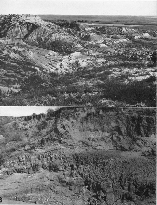
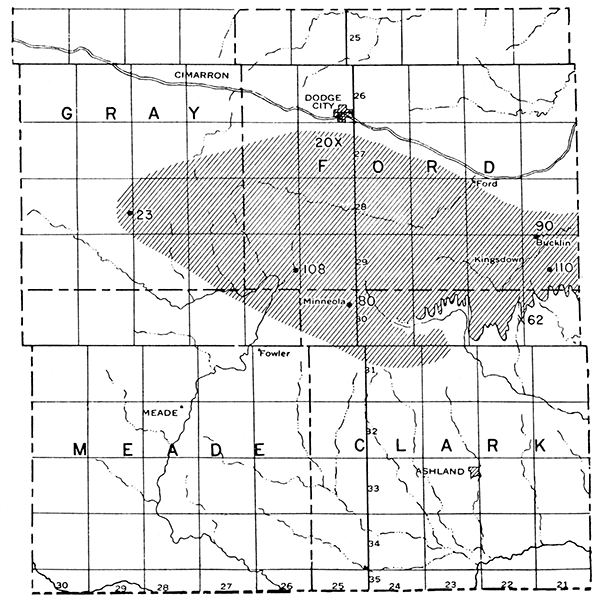
The Kingsdown formation consists of light-colored sand and gravel grading upward into the characteristic light-buff, even-bedded silt and clay, containing some small and scattered calcareous concretions. It is widely exposed in northern Clark County and southern Ford County. Well records indicate that its thickness reaches 110 feet. The formation is very soft, and easily eroded to form characteristic narrow, steep-sided gulches of the badland type (pl. 16) . The name revives Cragin's loosely defined "Kingsdown marl" (1896), of supposed late Pliocene age, here redefined to include beds of Pleistocene age only. It was included in the "Tertiary marl" as mapped by Hay (1890, p. 1).
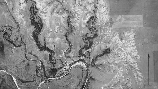
Plate 16--Aerial photograph of the Bluff Creek Bend area. Note the shallow upland watercourse aligned with Bluff creek in the northeastern corner of the picture suggesting piracy. Note, also, the contour furrowing and the intricate gullying of the Kingsdown formation. The arrow points north, and is about 0.5 mile long. Photograph from U. S. Agricultural Adjustment Administration, October, 1938.
Areal Description
The best exposures of the Kingsdown formation are found along the upper stretches of Bluff creek, and along its northerly tributaries. The following typical section was measured on the west bluff of a small tributary on the Stephenson ranch, about 0.5 mile from its junction with Bluff creek (sec. 13, T. 30 S., R. 23 W.). (pl. 16):
| Section of the Kingsdown formation in sec. 13, T. 30 S., R. 23 W., Clark County, Kansas | Thickness in feet |
||
|---|---|---|---|
| Quaternary system | |||
| Kingsdown formation | |||
| 4. Silt, light-buff, clayey, even-bedded to finely laminated below, grading into structureless, loess-like silt toward top | 46 | ||
| 3. Sand, silty, gray, containing small pebbly bands below, grading into structureless calcareous silt above; abundant invertebrates | 16 | ||
| 2. Sand and gravel, rusty to sooty-black, abundant calcareous pebbles and fragmentary slabs of mortar-bed conglomerate, obviously reworked; contacts indistinct | 2 | ||
| Rexroad formation | |||
| 1. Sand and gravel, well cemented toward top | 26 | ||
The section begins 15 feet above floodplain level. The basal 26 feet, and possibly also the next 2 feet, belong to the Rexroad formation. The vertebra of some large, extinct type of bison was found about 5 feet from the bottom of division No. 4.
Just west of the above section, on the east side of the next valley, 5 feet of clean, even-bedded volcanic ash occurs near the base of the Kingsdown. The ash is underlain by a few feet of gray sand, and this, in turn, by rusty sand and gravel. The ash is overlain by 50 feet of buff silt, evenly laminated in the lower part. Other outcrops of ash are found in the next two valleys to the west, thus extending its outcrop belt to a distance of nearly a mile.
About 2.5 miles south of the Stephenson ranch section, on the east side of Bluff creek, overlooking Clark County State Lake, the capping limestone of the Ogallala is overlain by 40 feet of buff-colored sand and silt of the Kingsdown formation, poorly exposed in the upper portion.
About 4 miles west of the Stephenson ranch section, along a small valley in the N2 sec. 20, T. 30 S., R. 23 W., 40 feet of finely laminated gray to buff and brown silt, clay, and fine sand is exposed (pl. 15B). These beds are seen to be underlain locally by sand and gravel containing abundant concretionary pebbles of limestone, seemingly eroded from the Ogallala. A few miles west of this locality there are some additional deposits of volcanic ash.
Exposures similar to those described above occur in many places along Mulberry creek and along the headwaters of Rattlesnake creek and its tributaries in the vicinity of Bucklin. Similar beds were observed by me also a few miles northwest of Greensburg in Kiowa County, and in the southern part of the city of Pratt, in Pratt county. There is no reason for believing the latter to be continuous with the Kingsdown beds farther west, on basis of present knowledge.
In Ford County, some additional data on the formation are given by well records. At Bucklin, the municipal water well was reported to' have been dug in clay to a depth of 90 feet, and in sand and gravel from that point to the bottom at 116 feet. The "clay" undoubtedly represents Kingsdown silt. South-southeast of Bucklin, in sec. 22, T. 29 S., R. 21 W., an oil-well log reports "clay" to a depth of 110 feet. A well near Minneola, in northwestern Clark County, records "yellow clayey shale", underlain by "gray sandstone", to a depth of 80 feet (Moore and Haynes, 1917, p. 252). The former undoubtedly represents Kingsdown beds. Water-well logs in southwestern Ford County (Lohman, 1938) indicate as much as 108 feet of Kingsdown.
The northernmost exposure of Kingsdown observed by me is located a few miles south of Dodge City, along a shallow valley in sec. 14, T. 27 S., R. 25 W., where about 20 feet of silty, fine sand is exposed. The westernmost extent of the Kingsdown is suggested by the log of the railroad well at Montezuma, which reports "clay" to a depth of 23 feet.
The inferred extent of the Kingsdown is shown in figure 12. Its western extension is uncertain, and is inferred only from topographic expression. The area shown on the map is probably a minimum. Additional information will undoubtedly be obtained from drilling. Even this, however, cannot be expected to give complete information, for the Kinsgdown is overlain by loess, and seems locally to grade upward into loess, from which it differs little except in its bedding. Neither from well records or samples, from indifferent exposures, nor from topographic expression is it to be expected that the Kingsdown can be satisfactorily differentiated from the loess.
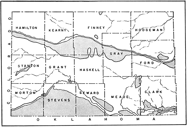
Figure 12--Sketch map showing distribution of the Kingsdown formation. Crosses indicate exposures and dots show wells at which thickness, noted in figures, was determined.
Age of the Kingsdown Beds
Very few vertebrate fossils have been found in the Kingsdown deposits. Hay (1917, p. 42) reports that Cragin found Elephas columbi along the upper part of Bluff creek, on the Thomas ranch. Williston (1897, p. 303) reports teeth of Equus occidentalis from Bluff creek, but gives no details. Hibbard, in company with me and others, found one vertebra of Bison in the Stephenson ranch section. This fossil did not permit of specific identification, but does indicate some large, extinct type of bison, suggesting middle or late Pleistocene age. Inasmuch as no bison remains whatever have been found in the other Pleistocene deposits already described, this specimen suggests further that the Kingsdown is younger than those deposits.
Origin of the Formation
The origin of the Kingsdown formation presents many problems, some of which cannot be solved until its extent, thickness, and subsurface relations are better known. The basal sand and gravel was undoubtedly derived from erosion of the Ogallala, and perhaps also of the Rexroad rocks. The abundant silt characterizing the greater part of the formation, however, seems adequately explained only by derivation from eolian loess. The even bedding and fine lamination indicate subaqueous deposition, either by floodwaters or under lacustrine conditions. If lacustrine conditions existed, it is possible that some of the material may have settled directly from the air into the water. The thickness of the formation, however, is too great to be explained wholly on this basis, and fits better with the postulate of material supplied by erosion of loess deposits, either contemporaneous or older, to the west.
The drainage conditions at the time of deposition were undoubtedly different from those of the present. In all probability Bluff creek, if it existed at all, had not yet been beheaded, and its upper stretches still formed a part of the Rattlesnake creek drainage. The same may have been true of Mulberry creek.
The cause of deposition is puzzling. Climatic changes alone seem hardly competent, and would fail to account for the exceptional thickness in one restricted area. They may have been a contributing factor, however, in supplying easily eroded and transported eolian material at a time when other causes were operative. Ultimately, deposition must have been due to a flattening or actual reversal of stream gradients, and this could be explained only as a result of crustal warping. Significant, perhaps, is the fact that the Kingsdown formation occurs in an area where: (1) the general land surface is higher south of the Arkansas valley than on the north; (2) Arkansas river begins its swing northeastward into the very anomalous Great Bend; (3) the Arkansas is perched as much as 180 feet higher than its parallel tributary valleys, Buckner creek, Pawnee river, and Walnut creek, on the north, and (4) the outer Arkansas valley and the sand-hill belt to the west are abnormally wide. It is a plausible surmise that these relations and the deposition of the Kingsdown may be traceable to related tectonic causes. The locus and the timing of the inferred differential warping, however, cannot be ascertained from information now available; possibly it began before the deposition of the Kingsdown beds, and continued during and after that event. The surface of the formation, in fact, does seem to be arched in a north-south direction, pointing to postKingsdown movement.
Volcanic Ash Deposits
General Character
The volcanic ash deposits of southwestern Kansas are mapped in figure 13. All except the one in southern Hamilton County are believed to be of Pleistocene age. The individual deposits represent small, completely isolated bodies, and do not constitute any definite stratigraphic unit to which a formation name seems applicable. All the deposits are essentially similar in lithology, as summarized below. For additional details, the reader is referred to the bulletin by Landes (1928).
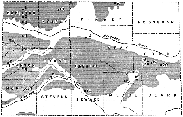
Figure 13--Map showing location of volcanic ash deposits in southwestern Kansas.
The color of the typical pure ash ranges from snow white to light gray. Where impure, owing to admixture of silt or clay, the color verges toward light buff or darker gray. It differs from calcareous deposits of similar color in texture, structure, and failure to effervesce with acid. The ash is characteristically fine grained, but displays minor variations in texture, and in proportion of impurities, from bed to bed. The loose ash is very gritty to the touch, and is dusty and easily blown into the air. Under a magnifying lens it is seen to be composed mainly of angular and extremely irregular shards. Except for a minor degree of bonding by silt and clay impurities, the ash is virtually unindurated.
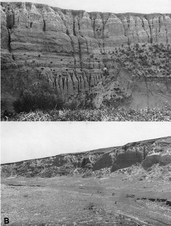
All deposits of ash examined by me display a fine and remarkably even bedding or lamination, layers on the order of an inch in thickness persisting unchanged to the limits of the exposure, or for distances of as much as 100 feet (pl. 17A). Individual beds in many places show current and oscillation ripples, delicate channeling, and cross-bedding on a minute scale, such as are typical of quiet-water conditions. Breaking the general regularity of the bedding at scattered points on different levels, however, are old channels exhibiting more conspicuous cross-bedding on a much larger scale (pl. 17B). At most exposures, the bedding of the ash is essentially flat, but at several places it has been tilted locally, seemingly by solution and collapse of underlying beds, and shows dips of as much as 13°.
Plate 17--Depositional structures in volcanic-ash beds about 5 miles north of Meade: A, Uniform, fine lamination. B, Channeling and concretionary structures.
Calcareous concretions are common in the ash. They show a wide variety of shapes, but most conspicuous is an upright, rodlike type, which weathers in relief on old cuts to assume the appearance of an icicle or stalactite (pl. 17B). This type seemingly was formed by deposition around plant stems followed by deposition in the tubular opening left by rotting of the organic material.
The thickness of the ash ranges from a few feet to a maximum of about 20 feet, and probably averages between 5 and 8 feet. The extent of individual deposits is small, owing seemingly both to the small size of the original deposit and to subsequent reduction by erosion. The average extent is probably only a small fraction of a section.
Owing to the softness of the ash, natural exposures are few, and for the most part occur only on steep slopes freshened by erosion. Where it does crop out, however, the ash is distinctive in color and texture. In a few places, the ash was first brought to light by the burrowing of gophers.
Occurrence
In the following discussion the ash deposits are described by general geographic groups. Detailed locations of individual deposits are given in a subsequent section on mineral resources.
The known volcanic ash deposits of Clark County occur along the headwaters of Bluff creek. All are close to the 2400-foot contour, those at the west being slightly above, and those to the east at or slightly below that level. Where exposures are adequate, the ash is seen to be underlain by sand or silt, and overlain by silt or fine sand. Invertebrates are present in both underlying and overlying beds at some places. The westernmost deposit of this group has been deformed, and shows a dip of 13°. All these deposits seem to represent local lenses of the Kingsdown formation.
The ash deposits of Meade County are all in the drainage area of Crooked creek, and are mostly clustered about the 2500-foot contour, although a few on the western side occur slightly higher. With the exception of one deposit 1.5 miles west of Meade, and another 8 miles south of Meade, believed to be in the Odee formation, the overburden on the ash is thin, commonly less than 8 feet, and consists mainly of loess or its reworked equivalent. Many deposits are underlain by a plastic, greenish-gray clay containing invertebrates. The bedding in numerous deposits is flat, but in others it dips as much as 5°. The topographic setting of the ash deposits varies. Some deposits occur along small draws, whereas others are close to the upland level.
The ash deposits of Seward County are confined to the area bordering the Cimarron valley, and all occur near the upland level. They were seemingly deposited during a former erosion cycle when the Cimarron flowed at a much higher level than at present. One pit in the northwest corner of the county shows a dip of 13°; the others are essentially flat-lying.
The single deposit in southeastern Grant County visited by me is situated well below the upland level, and is probably younger than those of Seward County. It shows a low dip toward the Cimarron valley.
Age of the Ash Deposits
The ash deposits of northern Clark County are the same in age as the Kingsdown formation. Those of Meade County may represent a considerable range in age. One, at least, seems to be a lentil in the Odee formation. Another, about 1.5 miles west of Meade, is tilted, and shows jointing and slightly superior induration, suggesting a somewhat greater age than that of most other deposits. Conceivably, it may be as old as Tertiary. Possibly the tilted deposits, as a group, are older than those that are flat-lying. The latter certainly are very similar in their geologic setting, and may well be contemporaneous. In the clay underlying the large deposit 6 miles north of Meade, teeth of Equus niobrarensis were found, suggesting that the overlying ash may be essentially contemporaneous with the beds named for that fossil. However, no diagnostic fossils have been found in the ash, and physiographic relations are not entirely clear. Until more specific facts are at hand, the relations of these deposits to one another and to those of Clark County must remain conjectural. The one deposit in Grant County seems on physiographic grounds to be younger than those of Seward County, but the relative age of these with respect to those of Meade County is unknown.
Considerations of the origin of the volcanic ash suggest that any one episode of ash eruption must have affected an extremely large area, that all deposits resulting from such an eruption must have been contemporaneous, and that a very few such eruptions, possibly even a single one, would be entirely adequate to account for most of the known deposits. There is, however, no a priori reason for assuming that there were so few eruptions, or that the conditions affecting the concentration and preservation of the ash from anyone eruption were equally favorable over wide areas and in different drainage systems. Correlation of the ash deposits must rest on a basis more tangible than that of assumptions as to these factors.
In Nebraska, volcanic ash is reported to occur widely at the base of the Loveland formation, of post-Kansan pre-Iowan age (Lugn, 1935, p. 132). In western Iowa, also, volcanic ash has been described from the Loveland formation (Kay and Apfel, 1929, p. 121). It is reasonable to assume that some of the ash in Kansas is of the same age, but it is uncertain just which deposits may be so correlated.
Origin of the Ash Deposits
As pointed out by Landes (1928), the original source of the volcanic ash in Kansas must have been volcanic vents to the west, probably in northeastern New Mexico. From eruptions at that center, the ash was showered widely and more or less uniformly over the plains to form a temporary mantle. This primary deposit, however, was at once subjected to reworking, being drifted by the wind and carried along by surficial sheet wash where sufficient slope existed. Sooner or later, a portion of the original ash found its way into valleys, thence to be picked up by streams and redeposited as a secondary accumulation. The final deposition took place in quiet water, as testified by its bedding. Whether this was in lakes or on flooded valley flats is a more or less academic question, for there are many gradations between the two. The presence of distinct channels in several of the ash deposits, however, argues against the idea of a permanent lake or lakes for these particular deposits, and suggests that the valleys of sluggish, aggrading streams, perhaps similar to that of Crooked creek today, were the sites of deposition. Whether aggradation was caused by overloading of the streams with ash or by other factors affecting stream grades at the same time is unknown.
The topography of the area at the time of ash deposition was certainly different from that of the present. Relief was lower, valleys were comparatively shallow, streams were probably in a stage of maturity or old age, and little if any of the piracy responsible for the present courses of Bluff creek and Crooked creek had taken place.
Loess
Although long known from northwestern and central-western Kansas (Darton, 1905, p. 155, pl. 44), loess has not previously been recognized south of the Arkansas valley. The present study, however, shows it to be widely distributed in that part of the state, as indicated in figure 14. It is included in the areas mapped as Colby silt loam, Richfield silt loam, and probably also Richfield silty clay loam by the Soil Survey (Coffey and Rice, 1912), and seemingly is a part of the material designated as "Tertiary marl" by Hay (1890, pl. 1). Its thickness ranges from a few feet to several tens of feet.
Figure 14--Sketch map showing distribution of loess deposits in southwestern Kansas. The dots indicate locations of samples listed in table 3, and the numbering corresponds to that in the table.
The appearance of the loess is similar to that of typical loess everywhere, except that vertical parting is less prominent. The color ranges from light buff to dark brown, the latter being characteristic of the soil zone, and generally gradational downward into the former. The material is structureless and lacks bedding. In places it contains small, scattered concretionary nodules of limestone. It is of pulverulent texture, and is dusty to the touch. It differs from underlying Tertiary deposits in the virtual absence of any except very fine sand, and therefore cannot be regarded as a weathering product of subjacent strata. Mechanical analyses (table 3) made under my direction by William Truxal, Dale Harpster, and Eugene Maxwell show maxima in the .062-.031 mm division for most of the samples studied, and in the .125-.062 grade for a few of the samples. The former is particularly characteristic of eolian silt (Smith and Fraser, 1935). Fractions above .062 mm were separated by screening, and those below by the pipette method. Preliminary petrographic examination showed quartz and feldspar grains to be the predominant constituents of the loess, the feldspar displaying more or less incipient alteration. Virtually all of the samples except those taken in the humus zone effervesce readily with acid.
Table 3--Mechanical analyses of loess and associated materials. Analyses of non-loessial materials are in italics. The maxima for all samples are emphasized by heavier type.
| No. of sample |
Location | Depth of sample in feet |
Mechanical composition | Notes | |||||
|---|---|---|---|---|---|---|---|---|---|
| >0.5 mm |
0.5-.25 mm |
.25-.125 mm |
.125-.062 mm |
.062-.031 mm |
<.031 mm |
||||
| Hamilton County | |||||||||
| 1 | SE Sec. 36, T. 21 S., R. 41 W. | 2.5 | 0.03 | 1.0 | 6.5 | 49.4 | 34.5 | 8.7 | Road cut. |
| 2 | SW Sec. 31, T. 22 S., R. 40 W. | 2± | 1.8 | .9 | 6.8 | 27.9 | 47.0 | 15.7 | Road cut. |
| 3 | W2 Sec. 19, T. 23 S., R. 40 W. | 4 | 0 | .03 | 2.2 | 32.6 | 49.5 | 15.6 | Road cut. |
| 4 | SW Sec. 18, T. 25 S., R. 40 W. | 3± | .8 | 1.4 | 3.2 | 3.7 | 45.7 | 45.7 | Road cut. |
| 5 | NW Sec. 33, T. 25 S., R. 42 W. | 1.5 | . 02 | .2 | 2.0 | 20.2 | 41.5 | 36.1 | Road cut . |
| Stanton County | |||||||||
| 6 | NW Sec. 12, T. 27 S., R. 41 W. | 3 | 0 | .3 | 4.0 | 37.7 | 36.0 | 22.0 | Road cut. |
| 7 | SW Sec. 30, T. 28 S., R. 42 W. | 4 | .03 | .4 | 3.5 | 21.1 | 58.5 | 16.6 | Road cut. |
| 8 | NE Sec. 24, T. 29 S., R. 41 W. | 3 | 0 | .3 | 4.5 | 30.8 | 48.0 | 16.0 | Road cut. |
| Grant County | |||||||||
| 9 | E2 Sec. 21, T. 30 S., R. 37 W. | 6 | 0 | 1.6 | 3.4 | 40.4 | 38.5 | 16.2 | Road cut. |
| Kearny County | |||||||||
| 10 | SW Sec. 3, T. 22 S., R. 36 W. | 4 | .03 | .1 | 9.0 | 13.6 | 57.1 | 20.1 | Road cut. |
| Finney County | |||||||||
| 11 | NW Sec. 6, T. 21 S., R. 34 W. | 3 | .2 | .7 | 5.2 | 26.2 | 52.0 | 15.8 | Road cut. |
| 12 | NE Sec. 2, T. 21 S., R. 29 W. | 2± | 0 | .03 | 3.5 | 22.6 | 69.5 | 4.4 | Road cut. |
| 13a | Cent. Sec. 19, T. 25 S., R. 32 W. | 1-2.5 | 0 | 0 | 1.1 | 23.7 | 55.8 | 19.4 | Under dune sand in roadside pit. |
| l3b | Cent. Sec. 19, T. 25 S., R. 32 W. | 2.5-4.5 | 0 | 1.5 | 12.1 | 21.7 | 46.0 | 18.8 | Under dune sand in roadside pit. |
| Seward County | |||||||||
| 14a | NW Sec. 14, T. 32 S., R. 33 W. | 1.5 | .6 | 6.4 | 18.2 | 38.7 | 25.3 | 10.8 | Road cut. |
| 14b | NW Sec. 14, T. 32 S., R. 33 W. | 3 | .3 | 1.7 | 14.8 | 44.3 | 29.1 | 9.7 | Road cut. |
| Mead County | |||||||||
| 15 | W2 Sec. 2, T. 31. S., R. 28 W. | 3 | .03 | .7 | 2.8 | 28.3 | 55.4 | 12.8 | Above ash in Cudahy pit (pl. 18B). |
| 16a | S. Cent. Sec. 33, T. 30 S., R. 26 W. | 0.5 | 20.3 | 41.3 | 25.1 | 8.1 | 0.7 | 4.5 | Soil zone on dune sand |
| 16b | S. Cent. Sec. 33, T. 30 S., R. 26 W. | 2.5 | 26.7 | 46.2 | 15.5 | 7.2 | 0.9 | 3.6 | Dune sand. |
| 16c | S. Cent. Sec. 33, T. 30 S.; R. 26 W. | 6.0 | 7.5 | 27.6 | 27.1 | 17.2 | 11.5 | 9.0 | Weathered dune Rand? |
| 16d | S. Cent. Sec. 33, T. 30 S., R. 26 W. | 10.0 | 0.6 | 4.2 | 20.3 | 39.3 | 25.1 | 10.6 | Loess |
| 16e | S. Cent. Sec. 33, T. 30 S., R. 26 W. | 14.0 | 2.3 | 7.8 | 14.6 | 47.5 | 27.8 | Impure volcanic ash. | |
| 16f | S. Cent. Sec. 33, T. 30 S., R. 26 W. | 16 | 0 | .02 | 3.1 | 37.6 | 59.2 | Volcanic ash below loess | |
| Ford County | |||||||||
| 17 | W2 Sec. 36, T. 28 S., R. 25 W. | 4 | 0.1 | 0.9 | 8.3 | 32.1 | 28.1 | 30.4 | Road cut on U. S. 283. |
| 18 | E2 Sec. 23, T. 28 S., R. 25 W. | 5 | 0 | 1.4 | 2.9 | .4 | 62.6 | 32.8 | Road cut (possibly reworked). |
| 19 | E2 Sec. 29, T. 28 S., R. 24 W. | 3± | 0 | 1.9 | 6.2 | 35.3 | 42.0 | 15.0 | Road cut. |
| 20a | S2 Sec. 34, T. 28 S., R. 23 W. | 3± | 0.3 | 2.5 | 9.2 | 24.9 | 52.2 | 10.9 | Road cut; 3 ft. above gray band. |
| 20b | S2 Sec. 34, T. 28 S., R. 23 W. | 0 | 0.3 | 2.5 | 27.7 | 51.0 | 18.0 | Road cut; reddish zone 1 ft. below gray band. | |
| 20c | S2 Sec. 34, T. 28 S., R. 23 W. | 0.1 | 0.7 | 6.2 | 40.9 | 39.6 | 12.4 | Road cut; buff zone 6 ft. below gray layer. | |
Owing to the incoherent character of the loess, natural exposures are few and small. Road cuts and other man-made excavations provide virtually the only exposures available for study. Because these are generally shallow, the complete thickness of the loess is not readily determinable, and the irregularities of the buried pre-loess surface, if any, are concealed. Only in southern Ford County, along the Mulberry creek drainage, does the loess definitely seem to be very thick. About 5 miles south and 3 miles west of Ford (S2 sec. 34, T. 28 S., R. 23 W.), the loess is exposed through a vertical range of about 50 feet. About 25 feet above the valley bottom it contains a locally persistent and essentially horizontal reddish zone, overlain by a thin gray zone containing sand grains and some shards of volcanic ash, suggesting some interruption to deposition. The horizontality of these zones suggests that the loess is not merely a slope mantle, but represents a once-level fill, since dissected. The nature of the underlying topography is unknown, for no older deposits are exposed for considerable distances. The characteristic topographic expression of the loess in this locality is a shallow, steep-sided, flat-bottomed, U-shaped "draw" (pl. 18A) (compare Haworth, 1897, p. 25).
Plate 18--A, Typical topographic expression on thick loess deposits, about 6 miles south and 3 miles west of Ford. B, Loess overlying volcanic ash in large pit 6 miles north of Meade.
In the volcanic-ash pits 6 miles north of Meade (pl. 18B) and 1 mile east of Fowler, loess overlies volcanic ash. The contact between the two is moderately sharp, but is not marked by any soil zone, or other indication of elapse of a long time between the deposition of the one and of the other.
The erosional development of the area at the time of loess deposition probably differed from that of the present only in that the valleys were not yet so deep. The presence of dune sand over both terrace alluvium and deeply weathered loess in Finney County suggests that the loess does not post-date the terrace along the Arkansas valley. Additional information is wanting, and uncertainties are introduced by the lack of continuous exposures, and by difficulties in distinguishing original loess from redeposited alluvial silt. The latter, if uncontaminated by addition of coarser material, may be quite as structureless as the former, and for the same cause-the effect of plant roots in kneading together successive additions to the deposit and thus obliterating any stratification initially present.
The age of the loess can be stated only in relative terms, for it has yielded no fossils. At least in part, it probably belongs somewhere in the upper Pleistocene. It is younger than volcanic ash, and older than dune sand at the few localities where it is found in contact with one or the other of these. Possibly it is contemporaneous with and in part grades laterally into the Kingsdown formation. There is no reason, however, for assuming that the loess of the area is all of one age. In northwestern Kansas, two ages of loess have been described by Elias (1937), and in central-western Kansas similar relations were found by me during the summer of 1939. The younger loess of the latter area, in fact, seems to be much less deeply weathered than most of the loess in the southwestern part of the state. Possibly the loess mapped by the Soil Survey as Richland silt loam is of a different age than that mapped as Colby silt loam. Much detailed work will be required, however, to differentiate the loess deposits of the area south of the Arkansas valley definitely.
The source of the loess is uncertain. Much additional information on lateral variations in thickness, texture, and mineralogy, and on general regional relations, are needed to gain definite knowledge on this point.
Terrace Deposits
Quaternary terrace deposits are widely distributed along the Arkansas valley (Smith, 1938), and somewhat less widespread along the Cimarron valley. In both places they constitute an important source of commercial sand and gravel. Terrace alluvium occurs also along Bluff creek and along Crooked creek, but is of small extent and of somewhat. erratic disposition. The significance of these terrace deposits is discussed at greater length in the section on physiography.
The principal terrace of the Arkansas valley lies 15 to 25 feet above present river level, and averages about 20 feet. The exposed thickness of the terrace deposits ranges from about 8 to 20 feet, the base being concealed in many places. The material consists of clean, unconsolidated, cross-bedded sand, alternating from fine to coarse. The sand is more or less pebbly in many places, and there are lenticular beds of gravel. The larger pebbles in the gravel are commonly as much as twice the size of those found in the Ogallala in the vicinity. These deposits are locally stained rusty brown or black. Their age has not been definitely determined. Some fragmentary Bison and Equus material was found by me, and it is probable also that the Bison willistoni (believed by O. P. Hay to be Bison alleni), Elephas primigenius, and Equus excelsus, reported by Martin (1924) from the vicinity of Garden City, were found in the terrace fill. A few miles northeast of Garden City, remains of Citellus elegans (Kennicott) were taken from fine-grained alluvium overlying sand and gravel deposits seemingly graded to the river terrace, although not necessarily deposited by the river itself (Hibbard, 1938). These fossils point to late Pleistocene age. The topographic position of the terrace deposits is well below that of the Kingsdown, indicating that they are younger than that formation.
Terrace remnants along the Cimarron valley are scattered and inconspicuous. They occur at elevations ranging from 20 to 85 feet above present river level, and seem to fall into two or possibly three sets. They are underlain by sand and gravel similar to that of the Arkansas terrace, but containing also some pebbles of vesicular basalt, which is not found along the Arkansas valley. Pebbles of reworked Ogallala are numerous, but it is probable that much of the material in the gravels came directly from primary source areas. This is suggested by the size of the pebbles, which commonly reach lengths of 8 inches, and in Morton County attain the dimensions of cobblestones, as much as 12 inches long-far longer than any pebbles found in the Ogallala along the Cimarron valley in Kansas. The age of the Cimarron terrace deposits is not yet ascertainable. One indeterminate elephant tooth was found by me in gravel 80 feet above the Cimarron, and unconformable on deformed Odee, about 21 miles south of Meade. Other fossils have been reported from the Cimarron terrace deposits, but such as have been saved are still in the hands of local collectors, and have not been submitted to scientific study. Obviously the different terraces are of different ages, and probably all fall within the upper Pleistocene. Correlations with the Arkansas valley are wholly conjectural,
Quaternary Deposits of the Ashland Basin
In large sections of southern Clark County, the Permian redbeds are concealed by alluvial deposits extending 60 feet and more above present stream level, and reaching to undetermined depths below present stream grade. These deposits probably range in age from early Pleistocene to Recent, but represent isolated geographic units, and for the most part, in the absence of fossils, cannot be correlated with the deposits described above from other parts of the area. They are discussed here in one group because of inadequate knowledge of their relations, and in order to direct attention to the problems that they involve.
In the city of Ashland, water-bearing sand and gravel are reported to occur to depths of 120 feet. No sections of comparable thickness were found exposed at the surface in the course of my reconnaissance studies. Five miles west of Ashland, however, exposures were sufficiently good to reveal two ages of alluvium. The older, exposed in a 60-foot creek bluff, is lithologically similar to the Odee, at least in its lower part, and is provisionally correlated with that formation. The younger, a brownish-buff alluvium, forms a 35-foot cut-and-fill terrace against the Odee.
In southeastern Clark County, about 1 mile south of the Cimarron on state highway 34, and about 60 feet above river level (sees, 29 and 30, T. 34 S., R. 21 W.), numerous ventifacts (pl. 10B) were found in reddish gravelly sand of probable Pleistocene age. Most of the ventifacts are cut on chert, probably derived from the Day Creek dolomite. These may be equivalent to the "pitted cobbles" in northwestern Oklahoma described by Waring (1930), although the age of the latter is uncertain. Ventifacts were found also about 0.6 mile north of the Cimarron, and about 50 feet above stream level, in a thin layer of fine gravel exposed in a cut along the same road. Some additional specimens were found at a locality a few miles northeast, in the NW sec. 9, T. 34 S., R. 21 W. Whether the ventifacts in these localities all occur in deposits of the same age or not is not known. It may be noted again, however, that ventifacts occur also at the base of the Ogallala in Clark County.
The only fossil remains thus far reported from Clark County that may have been found in the Ashland basin are those of Elephas primigenius, noted by Williston (1897, p. 302) only as having been obtained "from the reddish alluvium of Clark County." In the absence of definite information, the dating of the deposits in southern Clark County must await future study. It may be surmised, however, that the younger deposits correspond either wholly or in part to the Gerlane formation described by Knight (1934) from the Medicine Lodge drainage in Barber county.
Dune Sand
Dune sand is widely distributed along the south side of the Arkansas valley and in the Cimarron Bend section, and is of more restricted occurrence in many other parts of the area (fig. 15). It is included in the Dunesand, Pratt loamy sand, Pratt sandy loam, and Richfield sandy loam of the Soil Survey (Coffey and Rice, 1912). The original dune sand has undergone considerable reworking by the wind in successive episodes of eolian activity, so that color, degree of weathering, and topographic expression vary widely from place to place. The origin and development of sand dunes is discussed more fully in the section on physiography.
Figure 15--Sketch map of dune-sand areas in southwestern Kansas.
The age of the dune sand cannot be stated definitely. It is certainly not of late Recent origin, however, as seems to have been assumed by some writers. In all probability, the original accumulation of dune sand took place at different times in different places, and the earliest accumulation may date well back into the Pleistocene. Of the deposits studied, the one having the appearance of greatest antiquity is exposed in the new cut of the Rock Island Railroad between Kismet and Cimarron river, in eastern Seward County. This locality illustrates also the range in age of dune-sand deposits, for it reveals two sands of different appearance, separated by a well-defined soil zone, and thus unquestionably of greatly different age. The upper and younger sand is by no means fresh in appearance, but is somewhat indurated, and displays a distinct soil zone and a more or less subdued topographic form. The older sand differs from the younger in its redder color, more advanced degree of induration and weathering, and obscure bedding.
No reason was found for believing that the dune sand is contemporaneous with loess. In the volcanic-ash pit near Fowler in Meade County and in a small pit along U. S. highway 83 about 7 miles south of Garden City (sec. 19, T. 25 S., R. 32 W.), the dune sand, in fact, overlies a thick soil zone on loess. Dune sand is also younger, although probably only slightly younger, than the terrace sand and gravel of the Arkansas valley, which widely underlies it. There seems to be no genetic relation between the present Arkansas flood plain and any of the dune sand.
Valley Fill
Late Quaternary alluvium floors the valleys of all the principal streams in the area. Along the Arkansas valley, the maximum thickness of the alluvium is about 60 feet, but the thickness varies both along and across the valley. At Syracuse, the log of one railroad well shows 63 feet of sand and gravel resting on black shale. Four other wells are reported to show thicknesses of 33, 24, 24, and 20 feet, respectively. In each case, however, the top of the well is somewhat above river level, possibly as much as 25 feet. At Kendall, Darton (1920, p. 10) reports 53 feet of river alluvium. At the "narrows", about 2 miles west of Hartland, Slichter (1906, pp. 23- 24) reports depths of about 40 feet to bedrock. East of this point, the base of the Ogallala plunges beneath river level, and well records fail to show a very sharp demarcation between Ogallala and Quaternary alluvium, but suggest that the thickness of the latter commonly ranges from 30 to 50 feet. Possibly a part of the valley fill in some places is of late Pleistocene age, and represents the basal part of a cut-and-fill terrace deposit.
Data on the depth of fill along the Cimarron valley are scanty, but indicate that it is at least 20 feet.
Along Crooked creek valley, the depth to bedrock locally exceeds 280 feet. Undoubtedly a part of the fill consists of Tertiary materials, a part Pleistocene, and a part Recent, but the proportions of each are unknown. Jay Ellis, a well driller of Meade, reported encountering a buried log in the fill at a depth of nearly 200 feet in a well on the west side of Crooked creek a few miles south of Meade. It is possible that a part of the valley fill north of Meade is of lacustrine origin. This is suggested by the evidence for relatively recent areal subsidence found in the bottleneck pattern of the 2,460- foot to 2,500-foot contours, by the large undrained depression westnorthwest from Fowler, by the marshy character of much of the bottom land, and by the low gradient and irregular peregrinations of Crooked creek through the basin area. It is interesting to note that the possibility of a lake was considered by Johnson (1901, p. 706), but was dismissed on the general grounds that Crooked creek could not supply enough water to fill the basin. His argument is not stated in quantitative terms, however, and fails to consider the probability that rainfall at various times in the past has been considerably greater than that of the present. If a lake existed, its deposits were later veneered with stream deposits.
Prev Page--Stratigraphy--Tertiary || Next Page--Structural Geology
Kansas Geological Survey, Geology
Placed on web Feb. 8, 2017; originally published September 15, 1940.
Comments to webadmin@kgs.ku.edu
The URL for this page is http://www.kgs.ku.edu/Publications/Bulletins/34/05_strat3.html