![]()
Prev Page--Physiography || Next Page--Bibliography
Economic Resources
Soils
Soil takes first place among the natural resources of southwestern Kansas, and with it must rank water, without which utilization of the soil would be impossible. It is upon these that the permanent economy of the area must be based. Other resources, although locally and temporarily important, are of minor significance from the long-range viewpoint, and are unlikely to, benefit more than a small percentage of the inhabitants.
The soils of the area have been described at length by Coffey and Rice (1912), and in more summary form by Hayes and Stoeckeler (1935) and by Joel (1937). In the greater part of the area, the soil has been developed on a loessial mantle, and elsewhere it was formed on dune sand, on floodplain and terrace alluvium, and on dissected slopes in Tertiary and older formations. The loessial soils are characteristic of the upland areas, and provide the main basis for the dry-farming industry.
Data on land utilization and agricultural economics for the counties in southwestern Kansas are presented in a report by Throckmorton, Hodges, Pine, and Grimes (1937). Although much of the area was used originally only as grazing land, the only large sections still devoted to stock raising are in southern Meade and Clark counties. Smaller areas of pasture land, however, are found in all the other counties, and are largest in the sand-hill belts and in the more deeply dissected zones. The rest of the region is under cultivation. Wheat is by far the most important crop. Of subordinate importance, listed in order of decreasing acreage, are: grain sorghums, corn, barley, oats, alfalfa, and sugar beets. The last is raised only along the Arkansas valley, mainly in Finney County. Alfalfa is almost restricted to the Arkansas valley.
Although constituting the most valuable natural resource of the area, soils have been seriously endangered by erosion over wide areas. In many places, in fact, they have been irremediably damaged, and unless proper conservation measures are carried out, the future prospects are none too encouraging. Erosion by water has been marked locally, but erosion by wind is of far greater importance. Each of these is considered below.
Soil Erosion by Water
Gullying and sheet wash in cultivated fields (pl. 32C) are important locally on the steeper slopes of the Cimarron drainage area. Both are favored by improper methods of cultivation and by attempts to farm slopes that are too steep to be kept under control easily. Remedial measures consist in terracing, contour tillage, strip-cropping, and other practices designed to retard surface runoff. A demonstration area to show the use of these methods has been set up by the U. S. Soil Conservation Service in north-central Seward County.
Roadside drainage ditches provide another common starting point for gullying in many places (pl. 32A). This may be retarded by the use of suitable check dams.
Gullying is by no means restricted to areas where the sod cover has been broken. It occurs also in places where the native vegetation has been merely weakened by overgrazing and drought (pl. 32B). This has the effect of increasing surface runoff, and thus leads to more rapid filling of water courses at times of torrential rainfall. Under conditions of lessened protection by vegetation, gullying results. With increased surface runoff there is decreased replenishment of soil moisture by infiltration, and as a consequence the grass is further weakened, and the danger of overgrazing becomes greater. The dividing line between safe grazing and overgrazing is relative, for the amount of grazing that any given area can safely support varies with the moisture available, and thus is lessened in time of drought, just when increased demands may be made upon it owing to shortage of feed. One remedial measure that promises to be of some help in preventing accelerated runoff is the use of pasture furrows on the contour (pl. 16).
Soil Erosion by Wind
Soil erosion by wind constitutes the most serious threat to the agricultural economy of large areas in southwestern Kansas. In the "Dust Bowl" counties (Hamilton, Stanton, Grant, Morton, Stevens, and Seward), it was found that the percentage of the total area seriously affected by wind erosion and accumulation ranged from 24.8 for Grant County to 74.8 for Stevens County, and averaged 55.7 percent for the six counties surveyed (Joel, 1937, p. 43).
The destructive effects of wind erosion are manifold. Most familiar and far-reaching are the dust storms. These constitute a menace to health and cause damage to automobiles, farm machinery, and other property, injury and loss of livestock, lower attendance at schools, suspension of travel and other activities, and generally lower morale of the people. More localized, but no less important, is the effect on soil, vegetation, and crops. In many places the topsoil has been thinned or removed, and--
the portion of the soil which contains most of the organic matter, most of the readily available plant food materials, and the part having the highest absorbing capacity for water is lost. (Throckmorton and Compton, 1938, p. 23.)
Growing crops are cut off, undermined, or buried by drifting soil (pl. 22A). Pasture land is commonly injured by the drifting of "dirt" from adjoining cultivated tracts. Roads are locally blocked, fences are choked, farmsteads invaded, and trees killed by drifting sand and silt (pl. 21).
In the area under discussion, soil "blowing" first reached serious proportions in 1934. The immediate cause lay in drought and crop failure, but wind erosion and dust storms were by no means unprecedented in the region, having been known locally for many decades (McDonald, 1938, pp. 7-12, Throckmorton and Compton, 1938, pp. 7-8). The unexampled magnitude and extent of these phenomena during recent years was primarily a result of the tremendously increased acreage under cultivation, and of the fact that within this acreage was included much marginal land.
Antecedent factors leading to the dusty years were deeply rooted in the political and economic history of the area, and are discussed at length in the report of the Great Plains Committee (1936). Outstanding in this history, however, were the facts that--
The World War and the following inflation pushed the price of wheat to new high levels and caused a remarkable extension of the area planted to this crop [wheat]. When the price collapsed during the post-war period Great Plains farmers continued to plant large wheat acreages in a desperate endeavor to get money with which to pay debt charges, taxes, and other unavoidable expenses. They had no choice in the matter. Without money they could not remain solvent or continue to farm. Yet to get money they were obliged to extend farming practices which were collectively ruinous. . . . But the result was actually to produce an unsalable surplus. (Great Plains Committee, 1936, p. 4).
Absentee ownership and operation, itself partly a result of these factors, contributed still further to the final outcome.
It is but an expression of human nature that renters and absentee owners are more interested in immediate returns than in future values. (Joel, 1937, p. 21).
Another contributing factor was poor soil management.
Much of the soil has received shallow cultivation as a result of the general use' of disk implements throughout the region, soil has been cultivated when extremely dry, and no effort has been made, in most cases, to return organic matter to the soil. These practices brought about a condition in which the immediate surface layer of soil became finely divided, low in organic matter, and subject to crusting immediately following a rain. When cultivated in a dry condition such a soil became loose and dusty. There are individual farmers throughout the region who have followed good methods of soil management and have found it possible to prevent soil blowing on their farms, except where soil blown from adjoining farms encroached upon their fields. (Throckmorton and Compton, 1938, pp. 19-20).
In the light of this background, the actual course of events may now be pictured. Drought first led to crop failure. This was followed in some places by abandonment of fields, and in others by attempts to raise a crop the following year. Abandonment of land without any protective cover gave the prevailingly high winds every opportunity to begin erosion. The loess and dune sand on which the soils of large areas had been developed provided excellent material for wind attack.
The relatively low precipitation, low relative humidity, and frequent winds all work toward the drying out of the soil. The rain or snow which fall during the critical winter and spring blowing periods are usually not sufficient to protect the soil by covering or moistening it for an appreciable length of time. In fact, such precipitation promotes erosion to some extent by having a loosening effect on the heavier soils, the result of alternate wetting and drying. Alternate freezing and thawing also work toward the same result. (Joel, 1937, p. 22).
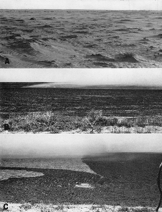
Abrasion by sand and soil particles thus loosened leads to the dislodging of others, and a vicious circle is inaugurated. Initial abrasion produces a surface of minimum resistance to the wind, and thus promotes further erosion. The coarser materials are swept along the surface of the ground (pl. 33A), until checked temporarily or permanently by obstacles, and the finer materials are carried aloft as, dust. These conditions prevent the growth of any type of vegetation, and lead to the development of a hard, tight surface that inhibits absorption of rain water, and favors rapid runoff where there is sufficient slope. Thus the soil remains dry, conditions remain adverse for plant growth, and even weeds cannot get a start. Starting from small local areas, erosion
may expand rapidly and lead to serious blowing over an entire farm. If there are many of these areas, they gradually unite so that blowing may occur over an entire county or several counties. (Throckmorton and Compton, 1938, p.21).
Plate 33--A, Wind-swept field between Liberal and Hugoton. B, Effect of the wind in stirring up dust on the uncultivated part of a field. The darker area has just been cultivated, and the lighter area has been smoothed and crusted by wind and rain since the last cultivation. The wind is blowing from left to right. The field is in northern Finney County. C, Dissipation of dust in passing from uncultivated to cultivated part of same field as above, summer, 1939.
To break this vicious circle, only the coming of an excessively moist period or the employment of artificial control measures can be, effective. The latter include such methods of cultivation as will break the force of the wind and at the same time promote the absorption of rain water by the soil, thus to make plant growth possible.
When crop failure was followed by cultivation and replanting, under conditions of continued deficiency in rainfall and soil moisture, and the continued use of incorrect methods, the results were aggravated. Such stubble as might have retarded wind attack was destroyed, and the working of the dry soil rendered it more susceptible to blowing. Another crop failure naturally followed, and unless precautionary measures were taken meanwhile, erosion proceeded apace.
In the control of wind erosion, preventive methods are obviously to be preferred. These consist essentially in protection of the soil (1) by permanent restoration of a vegetative cover, (2) through coverage with suitable crops adapted to the prevailing conditions, or (3) by mechanical methods of maintaining a surface of maximum resistance to wind attack. Methods directed toward these ends are described at some length by Chilcott (1937), Joel (1937), and Throckmorton and Compton (1938). Their recommendations may be summarized as follows:
(1) Moisture conservation. All practices that lead to replenishment of soil moisture help automatically to check wind erosion.
(2) Protection of soil during preparation for and starting of a crop. This involves the use of judicious methods and proper implements. It is recommended that stubble and crop residue be left on the ground as long as possible before cultivation for the next crop, and that this material be thoroughly worked into the soil when cultivation is started. Tillage should be undertaken only when the soil is moist, and should be such as to leave a ridged and cloddy surface. Furrows should be transverse to the direction of the prevailing winds if not on the contour. More specific procedures for varying conditions are given by Chilcott (1937).
(3) Strip farming. This involves the alternation of strips of wheat with strips either of fallow land or of row-crops. Strips should be laid out either on the contour or transverse to prevailing winds. This method, to be effective, must be used in conjunction with the other practices listed. It has not yet come into very wide usage in this area, although widely employed at other places. Obviously some experimentation may be needed to adapt it to local conditions and to determine its possibilities and limitations (Throckmorton and Compton, 1938, pp. 34-35; Chilcott, 1937, pp. 24-25).
(4) Avoidance of seeding when the soil is too dry.
Recent studies have indicated that unless the soil contains enough water to germinate wheat and maintain its fall growth there is little hope of maturing a paying yield. Nevertheless large acreages of wheat are planted nearly every year under such conditions. A considerable portion of this acreage is planted on late-prepared land as an adventure or gamble. (Chilcott, 1937, p. 15).
Instead, the land should be left in stubble or deeply furrowed.
(5) Protection of ground after failure of wheat crop. The use of off-season emergency cover crops is recommended by Joel (1937, p.49).
(6) Windbreaks. Where conditions are favorable, for their survival, rows of trees help locally to decrease the force of the wind and check the drifting of soil from one field to another. Buffer strips of shrubs help partly to serve the same purpose (Chilcott, 1937, p. 23). Trees also have the advantage of protecting the farmyard and making it more livable. Recently, large-scale tree planting has been undertaken by the Federal Government in connection with the Shelterbelt Project (Zon, 1935). The results of this experiment may be awaited with considerable interest.
(7) Permanent revegetation of marginal land. It was early concluded by Johnson (1902, p. 653) that much of the High Plains area is "hopelessly nonagricultural" and suited only for grazing. Recent events lend support to his judgment. Of the nine soil groups distinguished in Joel's survey (1937), it was concluded that at least five are unsuited for farming, and should be returned to pasture land. The areas covered by the latter comprise a large percentage of the total acreage, and consist principally of ancient dune sand.
Much of the land on which wind erosion is most severe should never have been plowed in the first place, and can never be expected to permit crop production at a profit under average conditions of rainfall. Obviously, the only permanent solution for the problem of wind erosion must entail provisions for the reestablishment of a vegetative cover on this land, and its restriction to grazing use thereafter. This is a difficult and costly procedure, and, if done on a large scale, must involve certain economic and sociological readjustments. It is a step hardly within the reach of the average landowner, but rather to be undertaken by governmental agencies. Some progress in this direction has already been made, and certain tracts in Morton County have been taken over by the Resettlement Administration. As a result of conservation measures in these areas, fields that I observed to be bare and blowing badly in 1937 were seen to be well covered by weeds in 1939. Although regrassing is the ultimate goal, some experimentation as to feasible methods seems to be needed, and a cover of weeds at least provides protection against wind attack.
Although prevention is the desideratum, there frequently arises the need for emergency palliative measures when wind erosion does begin, and such measures, in fact, are required by state law (Throckmorton and Compton, 1938, pp. 45-47). These emergency measures are almost wholly of a mechanical nature (Rule, 1937), and consist in the use of such tillage methods as will leave a rough, cloddy surface on the ground. Immediate action is necessary to prevent the enlargement of spots where blowing starts. Deep furrowing with the "lister" type of plow has been especially recommended. The effect of this is greatly to increase the frictional resistance offered to the wind, and thus to check its velocity nearest the ground surface. The furrows serve also to trap any soil material that may begin to drift, before it can gather momentum, and thus to prevent abrasive action. In some instances, furrowing in strips suffices to check wind attack, but where the danger of blowing is greater, solid "listing" of the entire area may be necessary. In both cases, the furrows should be transverse to the direction of the prevailing winds. However--
Listing is not a very effective means of preventing soil blowing on the more sandy types of soil, and usually cannot be employed to advantage on such soils. (Throckmorton and Compton, 1938, p. 41.)
Obviously, the surface roughening produced by any method of tillage is temporary. Although checked, wind action is not wholly prevented. Not all winds blow from the prevailing direction, and some will blow more nearly parallel to the furrows, and thus meet with less resistance. Hence there is a tendency for the furrows to be gradually modified. The impact of falling rain is an important factor also, for it tends to pack and "puddle" the upturned soil, and to smooth out the surface irregularities. Resistance to the sweep of the wind is decreased, and finally a point is reached at which repeated cultivation becomes necessary. In fact, a marked increase in the amount of dust in the air is commonly observed within a day or two after heavy rainfall. Plate 33 shows the contrast in wind action between that part of a field just cultivated (darker color) and the part not yet cultivated. The gusts of wind stir up no dust before reaching the uncultivated part, but produce dust aplenty as soon as the dividing line is crossed. On the leeward side of the uncultivated patch, the coarser particles carried nearer the ground are quickly dropped, allowing the finer dust carried higher up to thin out gradually for want of replenishment.
The control of drifting dune sand presents a somewhat different problem. Locally, snow fences are used to check the drifting of sand across roads, etc. Other control measures on a larger scale have recently been worked out by Whitfield (1939) on an experimental tract near Dalhart, Texas. His procedure consists in: (1) mechanical methods of reducing dune height; (2) deep listing of surrounding ground to check movement of sand to and from dunes; and (3) development of a suitable crop or of a cover of native vegetation, using prescribed methods of tillage. The applicability of these methods to other areas remains to be tested. The experimental area itself seems to lie in an old-age dune topography, where there has been opportunity for the development of a moderately deep and stable soil cover. As a result of artificial disturbance of this soil, small active dunes were developed, and it was for these that the control measures were devised. Whether or not the remedial practices suited for these conditions can also be applied to drifting sand derived from dunes less advanced in the cycle, or to active dunes that developed under natural conditions, cannot easily be predicted. The mechanical composition of the drifting sand is also a factor of importance. If, as seems probable, the dunes of the experimental tract contain a considerable percentage of silt and clay pellets, as do the fence-line dunes discussed on preceding pages of this report, stabilization would naturally be easier than on dunes composed entirely of true sand. Further studies of these factors would be of considerable interest.
The long-range problems of land utilization, however, do not end with the control of wind erosion of soil. To insure a permanently stable agricultural economy, it is necessary that provisions be made for checking unwarranted expansion during periods of abnormal rainfall, and for meeting the exigencies of intervening dry periods, which have been repeated more than once in the past, and will undoubtedly recur in the future. In past decades, these climatic fluctuations have led to alternations from "boom" times, agricultural expansion, rising land values, and immigration, to depressions, crop failure, bankruptcy, and emigration. To minimize such effects in the future, and to establish a greater degree of security for the permanent inhabitants of the area, extended readjustments in land utilization policies seem to be in order. These would necessarily have far-reaching implications of an economic and sociological nature, as well. For a discussion of these problems, the reader is referred to the reports of Joel (1937) and of the Great Plains Committee (1936).
Surface Waters
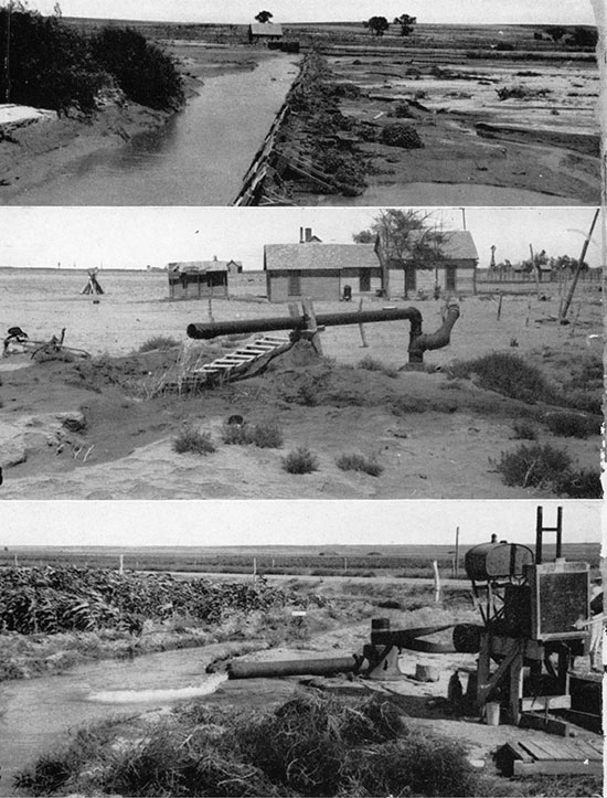
Surface waters are only locally of importance in southwestern Kansas. Along the Arkansas valley, river water is diverted (pl. 34A) for irrigation in Hamilton, Kearny, and Finney counties, and to a much smaller extent farther east. Some temporary storage of water is effected in a large shallow reservoir a few miles northeast of Lakin. At times of deficient flow in the river, a pumping plant at Deerfield, which has a capacity of about 22,500 gallons a minute, has been used to put well waters in one of the main ditches. Farther east, in Gray and Ford counties, a ditch leading onto the upland areas around Spearville was constructed at one time, but has been abandoned for lack of sufficient water to fill it. Much of what little surface flow enters the state is diverted before crossing the two westernmost counties, and heavy pumping at many places along the valley may also have some effect on stream flow. Quantitative data on stream flow are presented in reports issued by the Division of Water Resources of the Kansas State Board of Agriculture.
Plate 34--A, Diversion dam along Arkansas river a short distance west of Hartland. B, Old artesian well at Richfield. C, Pumping plant on the Clark farm, on the south side of the Arkansas valley a short distance west of Dodge City.
Along the Cimarron valley there is no diversion of water within the Kansas area, so far as I was able to learn. During the greater part of the year there is little flow, and it is doubtful that much of the valley land is irrigable. In 1902, however, Johnson (p. 664) wrote that--
At a point on the Cimarron where its valley bottom is abnormally broad-the Englewood Basin-a beginning in irrigation has been made. . . . Here, by ditch diversion, 1,200 acres are watered, and yet about a third only of the perennial run of the stream is utilized.
A map of the irrigated area was previously presented by Haworth (1897, pl. 12). It is reported that there is still some use of river water for irrigation on the Oklahoma side of the state line, but I did not have opportunity to learn any details.
Ground Water
General Relations
Together with soil, ground water is foremost in importance among the natural resources of southwestern Kansas. Upon it the stock-raising industry, a part of the agricultural industry, and the habitability of the area are dependent, and on it are based many hopes for the future. The validity of these hopes, and the soundness of any investments to which they may give rise, can be determined only from the results of detailed geologic and hydrologic studies.
The ground water of southwestern Kansas occurs under diverse conditions in rocks of widely differing age. A minor amount is obtained from the older redbeds, but this is strongly mineralized, and of slight usefulness. More is obtained from the Dakota sandstone, in small areas, and most from the Tertiary and Quaternary formations. In the pre-Tertiary beds, the water is commonly under some artesian pressure, and flowing wells are found in a few places. In the broad upland areas underlain by the Ogallala formation, the ground water is commonly referred to as "sheet water," and may be reached at virtually any place by drilling a well to a depth of 50 to 200 feet. Locally, in Meade County, artesian conditions exist in the Tertiary and Quaternary (?) aquifers, and there are many flowing wells. Along the Arkansas valley, water is obtained both from the Quaternary alluvium and from the underlying Ogallala where the latter is present. The depth to water nowhere exceeds a few tens of feet, and the volume of water is more than ample for all demands as yet made upon it. The ground water of the valley areas is commonly referred to as "underflow." Along the valleys of Buckner creek and of Cimarron river also, water is found in the alluvium at shallow depth.
Natural discharge of ground water by springs occurs in a few places, notably on the west side of Crooked creek valley south of Meade. These, however, constitute a very minor part of the total water supply.
Except for the water in the redbeds, the quality of the ground water in southwestern Kansas is satisfactory for all uses required of it. Detailed analyses have been presented by Parker (1911), and additional data will be provided in forthcoming reports on individual counties. The proportion of total dissolved solids ranges from about 200 to more than 1,000 parts per million, but averages about 350 parts. The composition of the water varies both laterally and vertically. Recently, special studies of the fluoride content of well waters have been made in connection with the problem of mottled enamel in children's teeth (Gottlieb, 1934; Boyce, 1934). Of the municipal well waters in this area, only those for the following towns were found to contain as much as one part per million of fluorides: Dodge City, Satanta, and Spearville. In 1939, however, the new analyses showed a fluoride content of only 0.4 part per million at Dodge City.
Detailed studies of the ground-water conditions in Ford, Stanton, and Morton counties have already been completed by other workers, and reports will soon be published. Studies in the other counties of this area are either in progress or in project. These studies, started in 1937, are being carried out jointly by the United States Geological Survey and the Kansas State Geological Survey, with cooperation from the Division of Sanitation of the State Board of Health and Division of Water Resources, State Board of Agriculture. In previous years, the measurement of ground-water levels in Finney and Scott counties had been started by the Division of Water Resources. At present, periodic water-level measurements in about 350 observation wells are being made by the state and federal agencies, and are recorded in the annual water-level reports of the Federal Geological Survey. In the present report, only a broad general outline of ground-water relations is essayed. For quantitative data and for a more detailed analysis of local hydrologic conditions, the reader is referred to the forthcoming separate reports on individual areas.
Utilization of Ground Water
The municipal water supplies of southwestern Kansas are all obtained from deep wells. The water is used for domestic and industrial purposes, for swimming pools, for irrigation of lawns and gardens, and, in recent years, for various types of air-conditioning equipment. Certain of the latter make extremely heavy demands on the ground-water supply, and introduce problems of returning water to the aquifers to prevent undue wastage.
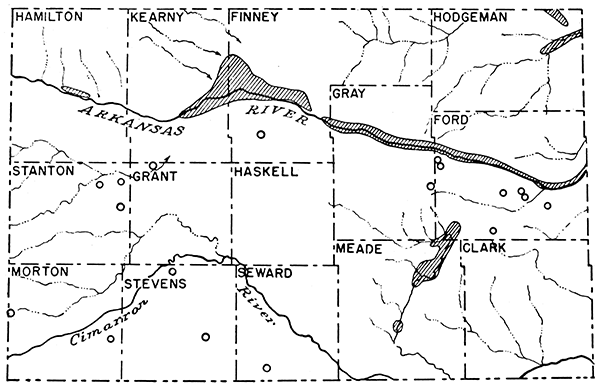
In rural areas, well water is used for household purposes, for watering livestock, and for irrigation (fig. 20). Wells of shallow to moderate depth, pumped by windmill power, commonly supply sufficient water for the first two of these uses. The requirements for irrigation on any very large scale, however, are much greater, and demand the use of larger or deeper wells and of power equipment for pumping. Along the Arkansas valley, where irrigation by pumping has been practiced for several decades, methods have been more or less standardized, and pumping presents no special problems. On the upland areas, however, the situation is different. The recent period of drought and crop failure has led to considerable interest in the possibilities of deep-well irrigation, and several experimental projects have been started. Some individuals, in fact, tend to look to irrigation as a general solution for all the difficulties of dry farming. A consideration of the conditions requisite for successful irrigation farming shows that the feasibility of general irrigation on the upland areas must depend on: (1) topography and soil, (2) adequacy of the ground-water supply, and (3) cost of pumping relative to profits obtained.
Figure 20--Map showing areas irrigated by pumping. The circles indicate isolated deep-well irrigation projects, as of 1938. Compiled with the assistance of Kenneth McCall and H. A. Waite.
Unless the topography is moderately flat, or can be artificially leveled, ditch construction is impractical. Unless the soil is sufficiently productive, and at least moderately retentive of water, irrigation would be of little avail. These particular requirements are satisfactorily met in large portions of the upland areas, however.
The adequacy of the water supply is relative. Broadly speaking, from a regional standpoint, the supply is certainly more than sufficient for present pumping demands. As emphasized by Johnson in 1902 (pp. 645-652), however, it is by no means inexhaustible, and there is very definitely a limit to the number of irrigation wells that can be put into operation without causing a general lowering of the water table. This point of safe yield can be estimated only from the results of detailed hydrologic surveys. From the local standpoint, the adequacy of the water supply depends on local conditions, particularly on the thickness and permeability of the water-bearing beds encountered in a well. These vary both locally and regionally. In any given locality, where the Ogallala is the aquifer, the lenticularity of the beds is commonly such as to cause wide variations in the yield of wells only a short distance apart. For this reason, it is good practice to drill a series of preliminary test holes before selecting the exact spot for the desired well. Then the hole that shows the greatest thickness of sand and gravel below water level may be enlarged to make a well. In some parts of the area, however, the chances of obtaining wells of sufficient yield to warrant irrigation are very meager. This applies particularly to those places where the Ogallala is thin, and the vertical distance from the water table to bedrock is small.
The relative cost of pumping is one of the most important factors of immediate concern when irrigation is contemplated. This is a complex factor, depending on several variables: (1) interest on the investment; (2) maintenance and depreciation of equipment; (3) depth from which water must be pumped; (4) type and cost of power used. The first of these depends on the cost of the well and pumping equipment, and the first two constitute fixed costs, which must be met regardless of how much or how little the equipment is used. In some instances, these costs may be kept at a minimum by using serviceable second-hand or improvised equipment, or by the owner's providing a part of the labor required to construct the well. The amount of power required for pumping varies directly with the height to which the water must be lifted, and depends on the type and efficiency of the pump. For the better wells of large capacity the draw-down ranges from 20 to 50 feet, but in many other wells it exceeds 100 feet. The cost of pumping for any given amount of lift depends upon the type of power used and varies with the prevailing rates at the particular locality. Data on these factors are set forth in reports of the Division of Water Resources of the State Board of Agriculture.
Obviously, the change from dry farming to irrigation farming can be successful only when the increase in profits realized exceeds the total cost of pumping. Other things being equal, this depends on the efficiency in the use of the water, and on the marketability of the crops produced. Efficiency in the use of water varies with the skill, experience, and industry of the individual farmer. The methods used in irrigation farming are different from those in dry farming, and cannot be learned overnight. Some information on this subject is given in a bulletin by Fortier (1932). The marketability of crops depends on the type of crop, on the demand, and on the distance to markets. These are factors that must be carefully evaluated for individual localities. Truck gardening, for example, might be profitable to the point of meeting the needs of near-by towns, but unprofitable in competition for more distant markets.
Thus many factors other than the geologic and the hydrologic determine the practicability of irrigation at particular places. The geologic and hydrologic factors, however, do impose certain absolute limitations, and in long-range planning these must be given full consideration.
Artesian Water in the Redbeds
Artesian water in the redbeds has been tapped in at least three places in Morton County, and is strongly mineralized. The first is in Richfield, where wells 600 to 700 feet deep were reported originally to have flowed at rates of 300 to 400 gallons a minute (Darton, 1905, p. 308; Haworth, 1913, p. 100). Today, the flow of the one well observed by me has dwindled to a mere trickle (pl. 34B), owing probably to rusting and clogging of the casing. This is confirmed by the report that water in surrounding shallow wells has been becoming harder, indicating leakage into and contamination of aquifers at higher levels.
One of the Elkhart city wells is reported to have encountered hard artesian water at a depth of 460 feet. This water rose within about 50 feet of the surface. It was plugged off.
A well drilled for gas along the Cimarron valley north of Elkhart (sec. 22, T. 34 S., R. 43 W.) is reported also to have encountered artesian water, at a depth of about 212 feet. This well was later plugged.
Although the volume of water in the redbeds may be considerable, the quality is poor, and it is not satisfactory for domestic or stock water. The intake areas and direction of movement are unknown.
Water in the Dakota Sandstone
The Dakota sandstone is an important aquifer in Stanton, Hamilton, Ford, and Hodgeman counties, and in parts of Morton County. Its possible significance in other places is overshadowed by the Ogallala formation, which provides all water needed over large areas. Ground-water conditions in the Syracuse and Lakin quadrangles have been described at length by Darton (1920). In this area, the aquifer or aquifers lie at depths as great as 400 feet. The water generally rises to a level within 100 feet of the surface, particularly along the Arkansas valley. At one time, there were several flowing wells in the vicinity of Coolidge (Haworth, 1913, p. 96). According to Darton, the Dakota water is comparatively soft, and of great volume.
Darton (1905, p. 308) reports that flowing wells were obtained at depths of 90 to 105 feet in the Dakota along the Cimarron valley south and southwest of Richfield. Recent studies, however, suggest some doubt as to his correlation of the water-bearing beds.
In Hodgeman County, a few wells draw their water from the Dakota, which lies at depths of as much as 800 feet (Moss, 1932, p. 45). Some flowing wells are reported to occur in the southern part of the county.
In southeastern Colorado, also, the Dakota is an important aquifer, and the water is under more or less artesian pressure at many places (Darton, 1906; Patton, 1924). Along the Arkansas valley, flowing wells were common between Las Animas and Florence when Darton wrote. Since that time, however, the flow of many wells has declined, and pumping has become necessary (Toepelman, 1924, p. 66).
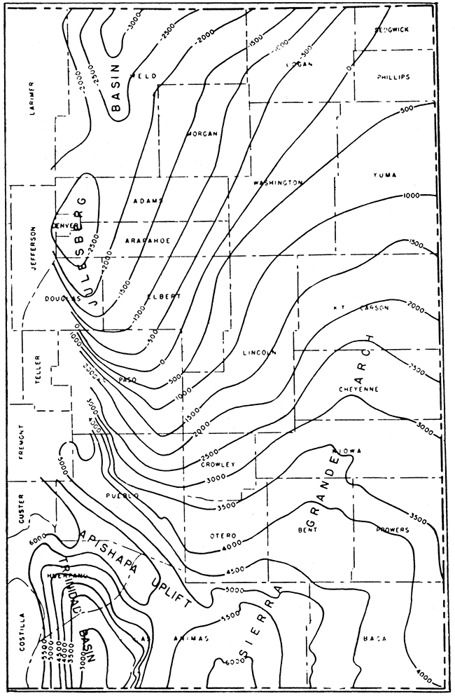
The Dakota water in southwestern Kansas is derived mainly from rainfall in southeastern Colorado. Contrary to popular belief and to the assumption of Haworth (1913, p. 99), there is no reason for believing that any of the water in the formation comes from the foothills of the Rockies. Inspection of the structural contours on the Dakota in eastern Colorado (fig. 21) shows that a broad structural arch forms a barrier between Kansas and the mountain areas. Inspection of the geologic map of Colorado shows also that the outcrop areas of the Dakota along the mountain front south of the Arkansas valley are cut off from areas to the east by the deep canyon of Purgatoire river. There is no need to search that far for a source of Dakota water, however. On the broad slopes of the Sierra Grande dome the Dakota crops out in an extensive area, and conditions are undoubtedly favorable for the infiltration of an important proportion of the rainfall. The structural slope toward the east and northeast accounts for the artesian pressure. On the lower flanks of the dome, the Dakota is overlain by the Ogallala formation, and may possibly receive some water from it. Possibly there is some recharge from a similar source farther east in Kansas, at places where the eroded edges of the Dakota are overlain by Ogallala and dip away from it (fig. 16).
Figure 21--Structural contour map on the top of the Dakota sandstone in eastern Colorado, by F. M. Van Tuyl, B. H. Parker, and W. H. Fenwick. Contour interval 500 feet. (Reprinted from the Guidebook for the 12th Annual Field Conference of the Kansas Geological Society.)
Ground Water in the Tertiary of the Upland Areas
In the upland or High Plains portions of the area, the Ogallala constitutes the principal aquifer. The Rexroad formation may be important locally, also, and if pre-Ogallala Tertiary beds are present, they also make up a part of the ground-water reservoir. The depth to water ranges from about 75 feet to 210 feet, and varies with surface topography, bedrock topography, and other factors. The depth of deep wells of large capacity ranges from 200 to 500 feet and probably averages about 300 feet. The amount of water available shows wide variations from place to place, and, for any specific well, depends on the depth from the water table to the bedrock floor (or bottom of the well), and on the lithology of the beds in this zone. Gravel and coarse sand yield water most readily, and are most lenticular and uncertain in distribution. These materials, however, are relatively more abundant in the lower part of the Ogallala.
For domestic and stock-watering purposes, where windmills are used for pumping, the pumping level departs but little from the static water level in the well, and generally the depth of the well below the water table need not be great. For wells of larger pumping capacity, such as those used for municipal supplies and for irrigation, the factor of draw-down must be considered, for the pumping level for maximum discharge may be as much as 150 feet below the static water level. Well construction is also an important factor in determining the yield of water, and gravel-walled wells of large diameter are generally found to be most satisfactory where the water must be obtained from fine-grained materials, as is commonly the case. Pumping capacity of wells in the upland areas is as much as 600 gallons a minute or even more. In the following paragraphs, ground-water conditions are discussed for each physiographic district.
Information on ground-water relations in the uplands of the Kearny area is meager, and no deep irrigation wells were reported. The depth to water is said to exceed 100 feet in much of the district, and in parts of northwestern Kearny County it is reported that no water is found in the Ogallala. These barren spots probably represent bedrock hills, where wells cannot reach the water table, or cannot tap beds that are sufficiently pervious to yield appreciable water.
In the southern part of the Scott-Finney depression, abundant water is obtained at moderate depth, and a large acreage is under irrigation. Some wells exceed 300 feet in depth. The depth to the main water-bearing beds is reported to be as much as 200 feet, but the static water level in wells lies only 50 to 80 feet below the surface. The pumping capacity of individual wells is reported to be as much as 1,700 gallons a minute, and draw-downs range from 40 to 120 feet.
Eastward in the Kalvesta area the supply of ground water is meager. The Ogallala is thin, and its ground water leaks out along the deeper valleys that trench the area. At Spearville, the main source of water is a dug well 7.5 feet in diameter and 85 feet deep. The well bottoms in Cretaceous rock. The static water level is about 75 feet. The pumping capacity is rated at 80 gallons a minute, but it is reported that the well can be pumped dry. At Wright, the depth to water is reported to be about 85 feet.
South of the Arkansas valley, ground-water conditions are equally variable. In the Syracuse upland, no water is to be had in the Ogallala. In the Stanton area, however, the supply is greater. The depth to water ranges from about 60 feet at Richfield to 165 feet at Johnson. In Ulysses, at the eastern edge of the area, the city wells are reported to be about 290 feet deep, and the static water level about 57 feet. The draw-down is reported to be about 50 feet at a pumping capacity of 200 gallons a minute. About 2 miles east and 1.5 miles south of Ulysses, a feebly flowing well occurs in the valley bottom. It is reported to be 220 feet deep. For additional information on the hydrology of the Stanton area, the reader is referred to forthcoming reports by T. G. McLaughlin and by Bruce Latta, and to the older work of Darton (1920) for information on those parts of the area not included in these reports.
In the Cimarron Bend area, the depth to water ranges from about 80 feet in the central part of the area to slightly more than 200 feet at the east, west, and south. At Liberal, there are several deep wells, the depths ranging to 500 feet. The depth to water in different parts of town is reported to range from 100 to 150 feet. In 1937, a new well to test irrigation possibilities was completed. The depth is 356 feet. This well is reported to yield 600 gallons a minute at a draw-down of 115 feet. At Hugoton, the main city well is reported to be slightly more than 300 feet deep, and the static water level 85 feet. On a 28-hour test, this well is reported to have yielded 245 gallons a minute, at a draw-down of 160 feet. The Heger irrigation well, located 8 miles east and 2 miles south of Hugoton (SE sec. 26, T. 33 S., R. 36 W.), is reported to have a static water level of 135 feet, and a pumping level about 30 feet lower for a discharge of 600 gallons a minute. Twelve miles north of Hugoton (sec. 9, T. 31 S., R. 37 W.), a well 256 feet deep is used for irrigation on a small scale. The reported water level is 87 feet. A cylindrical pump set at 131 feet was reported to deliver 20 gallons a minute. Elsewhere in the area, the depth to water is generally greater. At Moscow, it was reported to be 135 feet, at Rolla, 200 feet, and at Elkhart, 200 feet. At many places in this area, the farmers who were interested have had opportunity to reclaim water wells that were originally drilled for water to supply steam for the drilling of gas wells. The abundant supply of natural gas provides ideal fuel for power-pumping equipment.
In the Haskell area, the depth to water ranges from about 150 feet at Plains to 200 feet at Satanta. At Copeland, the reported depth is 120 feet. The city wells there are about 250 feet deep, and one well is reported to have yielded 250 gallons a minute with negligible draw-down. At Sublette, the depth to water is 200 feet. The deeper of the city wells is 348 feet. It is reported to yield 160 gallons a minute with a draw-down of 26 feet. At Satanta, the water level is reported to lie at a depth of 190 feet in the municipal well and 220 feet in the railroad well. The former is reported to yield 200 gallons a minute with a 40-foot draw-down.
Data for the Finney sand plain are meager, but topographic relations suggest that the water table should be nearer the surface than in adjoining upland areas. This is true for the Engler well, located 8 miles south and 5 miles west of Garden City (sec. 32, T. 25 S., R. 33 W.). This well is about 80 feet deep and the water level is about 60 feet. It is reported to yield 600 gallons a minute, and the water is used for irrigation.
In the Minneola area, ground-water relations are variable. The depth to water is reported to be 95 feet at Minneola, 100 feet at Bucklin, and about 165 feet at Ensign (Lohman, 1938). The larger of the municipal wells at Minneola is reported to be about 145 feet deep, and to yield 100 gallons a minute with a 15-foot draw-down. Additional data on the northern part of the section are given in S. W. Lohman's report, and in a forthcoming report by H. A. Waite.
The rate and nature of ground-water recharge in the Ogallala formation is of great importance in any consideration of future possibilities for more widespread deep-well irrigation. The conditions of recharge in this area are essentially similar to those outlined by Schoff (1939, pp. 147-159) for Texas County, Oklahoma, and the reader is referred to Schoff's paper for a detailed discussion of the factors involved. In short, four possible sources may be considered for the ground water in the Ogallala: (1) infiltration of local rainfall; (2) inflow of ground water derived from rainfall on the formation in other areas; (3) recharge from influent streams; and (4) discharge from the eroded edges of the underlying Dakota sandstone.
Infiltration from local precipitation is undoubtedly small. In areas covered by the silt and clay of the Kingsdown formation, and by the widespread mantle of loess, the downward movement of rain water is greatly retarded, and the calcareous beds in the upper part of the Ogallala probably have relatively low permeability also. Furthermore, dry-farming methods aim at maximum utilization of rainfall for crop production. Under these conditions, the proportion of water returned to the atmosphere by evaporation and transpiration is large, and the proportion that reaches the water table is small. In areas of sandy soil, as in the Cimarron Bend area and the Finney sand plain, however, additions to the ground-water reservoir are probably somewhat larger in proportion. For the region as a whole, Theis (1937) estimates that of the total annual rainfall only about 0.5 inch actually reaches the water table, on the average. There is no reason to doubt that this estimate is of the correct order of magnitude for southwestern Kansas.
The possibility of subsurface inflow of water derived from precipitation on other areas may next be considered. The principal area involved is the outcrop zone of the Ogallala in southeastern Colorado, which is considerably smaller than the outcrop area in southwestern Kansas, and lies in a belt of still less rainfall. Although it is probable that some water does enter the area from this direction, it is doubtful whether it is very important quantitatively, except in the Stanton area. Within the area, however, there is probably appreciable migration of ground water down dip in the Ogallala from higher to lower ground. This applies particularly to the Finney basin, which is so disposed structurally as to receive the inflow from a large gathering ground to the north and northwest. The abundant supply of water at moderate depth in the southern part of the Scott-Finney depression and along the Arkansas valley is undoubtedly a result of these conditions.
The possibilities of recharge from stream channels are as yet difficult to estimate. Of the streams to be considered there are only Arkansas river, Whitewoman creek, Bear creek, and Cimarron river and its few tributaries. The nature of any interchange between these streams and the water table can be determined only when it is known whether the water table slopes toward or away from their channels, which is best worked out through the construction of water-table contour maps. These are in preparation for Ford, Morton, and Stanton counties, and conclusions drawn from them will be presented in the forthcoming reports on these counties. Available data for other parts of the area indicate that the water table slopes toward both Cimarron and Arkansas rivers, suggesting that these streams receive water from the ground-water reservoir rather than contribute to it.
The possibility of recharge from the underlying Dakota sandstone is limited to those parts of the area where that formation wedges out down dip beneath the Ogallala, or where the cover rock has been stripped off as a result of pre-Ogallala erosion. This condition is believed to exist mainly in the southwestern part of the area, and may result there in significant contributions to the water of the Ogallala. Detailed estimates, however, must await knowledge of water levels in the Ogallala and of hydrostatic head in the Dakota. Chemical analyses of well waters may be of assistance, also, in distinguishing places where this source of recharge is in effect. On the whole, it seems that infiltration of local rainfall is the main process of ground-water recharge in the Ogallala. Intake from other sources, although possibly of local importance, is probably of very minor significance for the region as a whole. Certainly in the Kalvesta area, the likelihood of any water entering from the west is slight, for it is probable that the Finney basin diverts any water moving from that direction. The same is true of the greater part of the Minneola area, which is cut off from areas to the west by the valley .of Crooked creek. Therefore, it may be concluded that the recharge of the ground-water reservoir is very slight, amounting only to a very small fraction of the annual precipitation, and that conservation of the ground-water supply is very desirable.
Artesian Water of the Meade Basin
The presence of artesian water in the Meade basin has long been known, and was described at length by Johnson (1901, pp. 712-728). Flowing wells are numerous in the west side of the topographic basin north of Meade, and water rises to shallow depths in the wells in other parts of the valley. When Johnson wrote (1901, p. 718), the maximum height of artesian rise was 22 feet above ground level.
The ground water of the Meade basin occurs primarily in Ogallala and Rexroad beds, and possibly also in Pleistocene sands and gravels. The artesian conditions are due to the presence of a broad downwarp in these beds, complicated in places by faulting. Quaternary clay beds probably constitute the confining cover, although it is possible that clay beds in the Rexroad may function in this capacity also.
A preliminary report on the Meade artesian basin by John C. Frye is to be published by the Geological Survey soon. Consequently, no attempt will be made here to outline hydrologic conditions fully.
Ground Water of the Valley Areas
Buckner Creek--Along Buckner creek, ample water is obtained at shallow depth from wells in the alluvium (Moss, 1932, p. 45). These well's range to 50 feet in depth. Jetmore and other towns along the valley derive their water supply from this source, and well water is used also for irrigation at many places.
Arkansas Valley--Along the bottom lands of the Arkansas valley, ground water is obtained from Quaternary alluvium west of Hartland, and from both the alluvium and' the Ogallala formation east of that point. The depth to water ranges from about 5 to 30 feet, increasing away from the river. Welts drawing water entirely from the alluvium have depths of 30 to 50 feet. The volume of water is more than ample for: present requirements. Detailed discussions of hydrologic conditions along the western part of the Arkansas valley are given by Slichter (1906) and by Darton (1920) and data for Ford County are contained in a report by H. A. Waite, to be published by the Geological Survey.
The ground water in the alluvium is reported to be considerably harder than that in the Ogallala, and, according to Slichter (1906, chap. 3), the hardness decreases somewhat with depth, and is greater under the floodplain than under the 8-foot terrace, or "second bottoms."
The tendency of the ground water near the surface in the bottom lands of the river to run high in solids seems to indicate that this increased hardness is due to the loss of the ground water by evaporation. The water plane in these bottom lands lies close to the surface of the ground and is subject to frequent fluctuations due to rain and changes of conditions in the river itself. These changes are sufficient to account for a large excess of dissolved solids in the surface waters, and it is believed that no other explanation is necessary. (Slichter, 1906, p. 48.)
The concentration of dissolved solids as a result of surface-water' irrigation upstream may be an additional contributing factor. In some places, the water on the south side of the river is reported to be softer than that on the north side. This may be due to an influx of. softer water from the bordering sand hills. Where Ogallala water is available, it is greatly preferred for domestic use, and in wells intended for that purpose the "first" water is generally cased off.
As to the origin of the "underflow" in the alluvium of the Arkansas valley, Slichter concluded that it was derived mainly from rainfall within the valley area, rather. than from river waters originating in Colorado, as popularly supposed. He found that (1906, pp. 5-6, 34):
(1) The water plane slopes to the east at the rate of about 7.5 feet per mile, and toward the river at the rate of 2 to 3 feet per mile.
(2) The moving ground water extends several miles north from the river valley. No north or south limit was found. . . . The rate of movement is, very uniform.
(3) The elevation of the water plane is very sensitive to the, amount of rainfall, the rise in the water plane (due to a rain) in the first bottoms being' greater than can be accounted for by the localized precipitation. ; . . The underflow has its origin in the rainfall on the sand hills south of the river and on the bottom lands and plains north of the river. . . . The sand hills constitute an essential part of the catchment area. . . . On the sandy bottom lands 60 percent of an' ordinary rain reaches the water plane as a permanent contribution.
(4) High water in the river has much less effect upon the level of the ground water than the rainfall, its influence being confined to a distance of a few hundred feet from the river channel. . . . A heavy rain contributes more water to the underflow than a flood.
(5) The water plane falls at a very rapid rate after its elevation has been increased by rainfall or by a flood in the river.
(6) The fact that the water plane lies for a considerable distance at a level lower than the river channel, even when there is water in the river for an extended length of time, and the rapid way in which the ground water sinks after its rise due to heavy rain, establishes the fact that the underground drainage through the sands and gravels beneath the river valley is more than sufficient to carry off all of the rainfall without runoff into the river channel,
Near Hartland, the base of the Ogallala passes under the valley floor, and to the east the Ogallala formation constitutes an important additional source of water in the valley area. The water in the Ogallala is considerably softer than that in the overlying alluvium, and in some places it is reported to be under a different hydrostatic head. Wells in the Ogallala are generally more than 180 feet deep.
The source of the ground water in the Ogallala of the Arkansas valley undoubtedly is mainly the precipitation on a broad intake area lying to the north, northwest, and south. The structural basin serves to concentrate waters coming in from several sides. Some recharge may be effected also from the Quaternary valley fill, at the west where it crosses the eroded edges of dipping pervious beds in the Ogallala. Supplied thus from the subsurface drainage of a much larger area, the volume of water within the limits of the valley area is very large.
The ground water of the Arkansas valley is extensively used for irrigation (pl. 34C). In many places, only the water of the alluvium is drawn upon, and a battery of shallow wells, connected to a single centrifugal pump, is used. Such a battery consists of a linear series of wells, spaced about 50 feet apart, and preferably aligned transverse to the axis of the valley. Such pumping units deliver 1,000 to 2,500 gallons a minute. It is believed by some persons, however, that a single deep well, fed from both the alluvium and the Ogallala, and pumped by a turbine pump, might be more efficient in areas where the Ogallala underlies the alluvium. During the season of heavy pumping (July and August), it is reported that the level of the "first" water is lowered a few feet, but recovers before the next pumping season.
In the sand-hill belt bordering the Arkansas valley, moderate supplies of soft water may be had in relatively shallow wells. These are used mainly for watering stock.
Cimarron Valley--Ground water lies at shallow depth along the Cimarron valley, but is little used except for domestic and stock water. It is probably derived in part from precipitation within the valley area, and in part from floodwaters of Cimarron river. particularly along the persistently dry stretches.
Oil and Gas
Oil and gas production in southwestern Kansas have been summarized by Vet Wiebe (1938,1939). Most important is the Hugoton gas field, which had produced 146,170,000,000 cubic feet of gas to the end of 1938.
Volcanic Ash
The volcanic-ash resources of southwestern Kansas have been described by Landes (1928, 1937). Most of the deposits listed by him were revisited by me and I found several additional deposits, not previously recorded. A list of the deposits inspected by me is given below (see fig. 13).
| Locations of volcanic ash deposits in southwestern Kansas | |
|---|---|
| Clark County | |
| Secs. 11 and 12, T. 30 S., R. 23 W.: Ash deposits occur along the sides of three small valleys tributary to Bluff creek. There has been virtually no exploitation. | |
| Sec. 19, T. 30 S., R. 23 W.: One small exposure was found on the side of a small draw in the northwestern corner of the section. It has not been opened. | |
| Sec. 24, T. 30 S.,. R. 24 W.: Small exposures occur on both sides of a small draw in the north-central part of the section. These are unexploited. | |
| Sec. 23, T. 30 S., R. 24 W.: A pit has been opened in dipping beds of ash, in the southeastern corner of the section. | |
| Meade County | |
| Sec. 33, T. 30 S., R. 26 W. (about 1 mile east of Fowler): A large pit was opened, but has been abandoned. | |
| Sec. 2, T. 31 S., R. 28 W. (about 6 miles north of Meade): The pit here is the largest in the area, and is being actively quarried for the Cudahy Packing Company. | |
| Secs. 11 and 12, T. 31 S., R. 28 W.: Several small abandoned pits were found in these sections. | |
| Sec. 33, T. 31 S., R. 28 W.: Abandoned workings occur in the southeastern corner of the section. | |
| Sec. 9, T. 32 S., R. 28 W. (2 miles west (if Meade): Two large abandoned pits are found on both sides of a small valley. | |
| Sec. 18, T. 32 S., R. 28 W.: A small pit has been opened in the northwestern part of the section. | |
| Sec. 13, T. 32 S., R. 28 W.: Volcanic ash crops out along a road cut in the southwestern part of the section. It has not been opened. | |
| Sec. 26, T. 32 S., R. 28 W.: Ash was being regularly hauled from a pit of moderate size at the time of my visit in 1937. | |
| Sec. 3, T. 33 S., R. 28 W.: Ash crops out along a road cut on the northeastern edge of the section. It has not been opened. | |
| Sec. 21, T. 33 S., R. 28 W.: A small deposit occurs just below the edge of the upland. It is unexploited and probably unexploitable, owing to overburden and inaccessibility. | |
| Seward County | |
| Sec. 13, T. 33 S., R. 32 W. (a few miles southwest of Kismet): A large pit at this locality has been abandoned. | |
| Sec. 35, T. 34 S., R. 31 W.: An exposure of ash was discovered in a field in the southeastern quarter of the section. It is a new locality, and unexploited. | |
| Sec. 7, T. 31 S., R. 34 W. (northwestern corner of the county): A very small pit was opened along the road in the southeastern part of the section. When visited, it seemed to have been untouched for some time. | |
| Sec. 19, T. 31 S., R. 34 W.: A fair-sized pit has been opened in the northeastern quarter of the section, but has not previously been placed on record. | |
| Grant County | |
| Sec. 24, T. 30 S., R. 35 W.: A pit of moderate size was found at this locality, but there were no indications of recent activity. | |
| Hamilton County | |
| Sec. 13, T. 26 S., R. 41 W.: An ash deposit of probable Tertiary age occurs on the west side of a small valley near the center of the section. Although once opened" it is no longer worked. | |
Virtually all of the workings listed as abandoned still contain large tonnages of volcanic ash, and could probably be reopened if market conditions warranted.
At present, the uses of the volcanic ash in the area are confined mainly to the making of scouring powder and other abrasives, and to use as a constituent of the oil-mat type of highway surfacing. Potential uses, as yet undeveloped, lie in the manufacture of cement and heat-insulation material (Landes, 1928), and in the preparation of ceramic glazes (Plummer, 1939).
Sand and Gravel
Sand and gravel used locally for road surfacing and in concrete are obtained from three sources: (1) stream channels, (2) terrace deposits, and (3) the Ogallala formation. Along Arkansas river, sand and gravel are obtained directly from the stream channel by the use of centrifugal pumps. Along some small dry stream courses, minor amounts of sand and gravel are excavated directly by shoveling. A more important source, however, is found in the terrace deposits. Along both the Arkansas and Cimarron valleys, these constitute the main source of supply. The location of the more important dry pits is shown in figure 22. In a very few places, sand and gravel are taken directly from the Ogallala, but this is generally impracticable, owing to the heavy overburden.
Figure 22--Map showing location of principal gravel pits.
"Caliche"
Hard calcareous beds in the upper part of the Ogallala are used in some places as road-surfacing material. The material is generally excavated in shallow upland pits,
Clay
Large deposits of clay occur in the upper Pliocene and Pleistocene beds of Meade County and adjoining areas. Although tests have not yet been made, it is possible that some of this material might be of suitable quality for commercial use. Clay and shale are abundant also in the Cretaceous formations.
Building Stone
Rock ranging in age from Permian to Pliocene has been used in various places as building stone. The most important, however, is the limestone of the Greenhorn formation. The harder sandstone beds of the Dakota are also used to some extent (Darton, 1920, p. 8; Bass, 1926, pp. 81-82). In southeastern Seward County, the lower Pliocene (?) chalk beds have been used locally for the construction of farm buildings, and, being easily cut with a saw, are well adapted for that purpose.
Prev Page--Physiography || Next Page--Bibliography
Kansas Geological Survey, Geology
Placed on web Feb. 8, 2017; originally published September 15, 1940.
Comments to webadmin@kgs.ku.edu
The URL for this page is http://www.kgs.ku.edu/Publications/Bulletins/34/08_econ.html