![]()
Prev Page--Stratigraphy || Next Page--Physiography
Structural Geology
Structures in Pre-Tertiary Formations
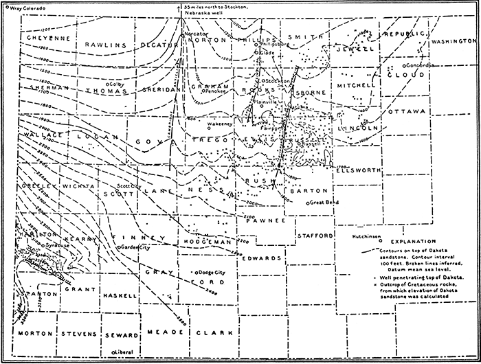
Of pre-Tertiary structures, only those in the Cretaceous have yet been described even in a general way. Bass's reconnaissance structural map of the Dakota sandstone, reproduced here as figure 16, shows a regional dip of about 20 feet per mile to the northeast. In southern Hamilton County there is a local dome named the Syracuse anticline, flanked on the southwest, in Stanton County, by a structural depression.
Figure 16--Reconnaissance structural contour map on the top of the Dakota sandstone in western Kansas. Reprinted from Bass (1926, pl. 7). [An Acrobat PDF version of this figure is available.]
Structures in Tertiary and Quaternary Beds
The regional dip of the Ogallala formation conforms to the plains surface in the greater part of the southwestern Kansas area. It ranges in amount from about 10 to 15 feet per mile, and in direction from southeast to east-northeast. These variations are believed to represent irregularities in broad regional upwarping of post-Ogallala date. At a few places there are sharp departures from and actual reversals of regional dip, and these constitute the structural features of principal interest. Evidence for their existence is mainly physiographic, and has been almost overlooked in the past. In addition, there are numerous minor and very local structures of solution-and-collapse origin. In the following paragraphs the minor structures are discussed first as a group, and then the major structures are described in order.
Minor Solution-and-Collapse Structures
Minor solution-and-collapse structures are indicated at many places by erratic dips in surface exposures, and at a few places may be observed in cross-section in deeper cuts. Some are so recent as to be marked by surface sinks or depressions, whereas others are so old as to have been deeply dissected. Both types are especially common in Meade and Clark counties.
Perhaps the best display of the results of solution and collapse is found at Big Basin and St. Jacob's Well, in western Clark County (secs. 24 and 25, T. 32 S., R. 25 W.). In St. Jacob's Well, one slump block of Ogallala shows a dip of about 35° (pl. 19B), and in Big Basin dips as steep as 30° may be observed in the steep bluffs rimming the basin (pl. 19A). In the bordering area the dips are gentler, as shown in ravines entering the depression (pl. 19C). Cracks and open fissures are numerous. In all instances, the distortion of the beds is disorderly, and takes the form of irregular sags of varying size, shape, and disposition. No clean-cut faults or systematic flexures were observed.
Plate 19--Solution-and-collapse structures. A. Sagging beds on east side of Big Basin. B. Slump block in St. Jacob's Well. C. Wavy dips just north of Big Basin. D. Collapse structure along Sand creek 5 miles east and 6 miles south of Meade.
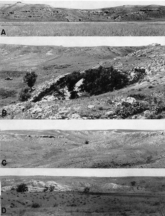
Older structures of similar character are exposed at the following localities: (1) on the north bank of Sand creek about 5 miles east and 6 miles south of Meade (sec. 3, T. 33 S., R. 27 W.) (pl. 19D); (2) on the east side of Crooked creek about 11 miles south of Meade (sec. 32, T. 33 S., R. 28 W.); (3) on the north bank of the Cimarron about 21 miles south of Meade. At the last locality, the deformation is less irregular than at most other places (pl. 14A). Other examples, less adequately exposed, are suggested by strong dips in volcanic-ash beds in northern Clark County and in northwestern Seward County, as noted in preceding pages. Gentler dips of similar origin are found at numerous places in the more dissected portions of Meade and Clark counties.
Where unconsolidated materials at the surface are affected by collapse, there is some tendency toward systematic structures of a very minor character. Typical forms are concentric slump cracks and scarps with centripetal dips, representing miniature landslide movements toward the center of the depression. These have been amply described and illustrated by Johnson (1901, pls. 131, 132, 136, 138).
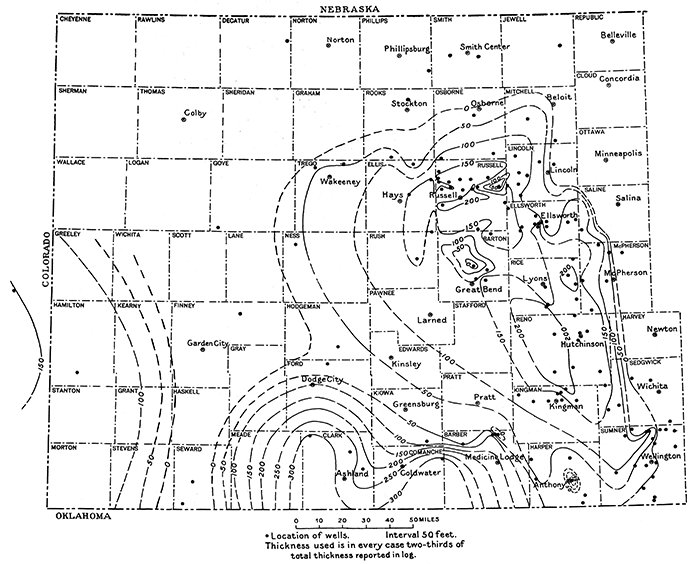
The minor structures described above are attributed to solution of underlying salt (or possibly gypsum) beds in the Permian, followed by collapse of insoluble roof rocks. Inspection of the isopach salt map (fig. 17) shows ideal conditions for this process, for the salt reaches a thickness of 300 feet, and its top lies at depths of 300 to 600 feet, being deeper toward the west than at the east.
Figure 17--Isopach map showing thickness of the Permian salt, reprinted from Bass (1926, pl. 8). [An Acrobat PDF version of this figure is available.]
Solution-and-collapse structures have been given little attention in geologic literature, and, to the best of my knowledge, the mechanics of their formation are yet to be studied. Simple deduction, however, indicates that the character of the deformation is governed chiefly by the following factors: (1) depth of the soluble bed or beds; (2) disposition of competent and incompetent beds in the roof rock; (3) shape, size, and spacing of solutional openings; and (4) mode of failure of the roof rock-whether piecemeal or massive, progressive or climactic. Very probably the progress of solution in salt is different from that in limestone, owing to the relative weakness and plasticity of the salt under load. A detailed analysis of these problems would undoubtedly be fruitful, but is beyond the scope of this paper. Such a study might well draw heavily on engineering investigations of subsidence in connection with coal and metal mining and salt extraction (Rice, 1923, Young, 1927).
The Meade Trough
The Meade trough is the only structure involving post-Cretaceous beds heretofore recognized in the area, having been described by Haworth as early as 1896. It represents both a topographic and a bedrock depression, the latter being of much greater relief than the former. The trough is about 30 miles long, and extends diagonally across central Meade County into southwestern Ford County (fig. 8), trending approximately north-northeast. Evidence for this structure is partly topographic, partly stratigraphic, and partly hydrologic, as outlined below.
The topographic evidence is perhaps most striking, and consists in the anomalous trend of Crooked creek valley transverse to the regional slope, in the bottleneck pattern of the contours north of Meade, and in the linear character of the valley for more than 10 miles south of Meade. Stratigraphic evidence for a bedrock trough, based both on surface outcrops and on well records, has already been presented in connection with the areal description of the Ogallala formation. Hydrologic evidence consists in the occurrence of artesian water throughout a long strip of the valley belt. Artesian conditions here can be satisfactorily explained only as a result of deformation of the aquifer and confining beds, and thus confirms conclusions from other lines of evidence.
The Meade trough was interpreted by Haworth (1896) as having been formed by a fault, of which the down throw side is the west side. His evidence, however, although clearly indicating the existence of a structural depression, fails to establish that this depression was caused wholly by faulting, and the possibility of an elongate downwarp, in part unbroken by faulting, seemingly was not considered.
Johnson (1901, pp. 711, 721-725) later took issue with Haworth, postulating that solution and collapse were alone adequate to account for the observed structural and topographic features. His essential arguments rested on: (1) The undoubted presence of considerable thicknesses of salt and gypsum, available to solution, at depth; (2) the large number and wide distribution of much smaller solution-and-collapse depressions, including some formed within historic time; and (3) the assumption that faulting was inimical to the production of artesian pressure. Stripped to their essentials, Johnson's contentions are hardly convincing, and represent unsubstantiated extrapolation from minor to major features. Objections may be summarized as follows: (1) there is little or no adequate geologic precedent for attributing so large a depression to the purely surficial processes in question. This in itself proves nothing, but seems to place the burden of proof on the investigator seeking to establish the new precedent. (2) The solution-and-collapse hypothesis fails to explain the notably elongate character of the depression. (3) This hypothesis fails also to account for the reversed asymmetry of the topography north and south of Meade, and for the discordance of topographic levels on the two sides of the depression, as shown in the profile, figure 18. (4) If solution and collapse occurred over so large an area, it obviously 'could not have been instantaneous, but must have been effected either by progressive lateral extension from a few initial lines or centers, or by the coalescence of many small depressions developed about innumerable local centers. In either case, it would be expected that there must have been extensive fracturing of the roof rock in the course of these readjustments, and that a very leaky condition would have been produced, leading to contamination of surface waters by saline solutions from depths. Thus it seems that the solution-and-collapse hypothesis raises more questions than it answers, and that a reexamination of Haworth's original interpretation is in order.
Figure 18--Topographic profile across the Crooked creek valley south of Meade. The position of the inferred fault is shown by a heavy vertical line.
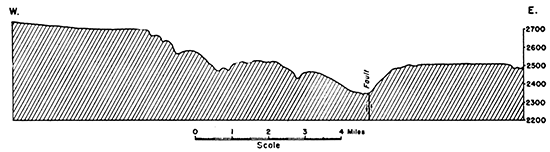
Haworth's faulting hypothesis seems to apply particularly well to the valley south of Meade. The linear character of the valley, the pronounced topographic asymmetry, and the abrupt descent of the bedrock floor directly west of the escarpment, are all readily explained by a fault of which the downthroW' side is the west side. The presence of minor faults at various places within the valley (pl. 14B) is also consistent with this hypothesis, although not necessarily confirmatory. The basin north of Meade, however, fails to display the more striking characters noted above. It slopes more gently toward the center from both sides, and is broadly rounded rather than linear. This suggests either that the fault passes northward into a simple downwarp, or that, if any faulting took place, it was of earlier date, and its topographic expression was obliterated by ensuing erosion and deposition.
On the basis of the tectonic hypothesis, the minor solution-and-collapse structures so common in Meade County may be regarded as results rather than as indicators of the cause of the structural depression. They would be explained as merely having been superimposed upon a tectonic trough, perhaps as a result of the directive effect of that structure on ground-water movement in the soluble beds.
A possible rejoinder to this explanation involves retention of solution and collapse as the primary cause of the trough, but may add that it was localized by a preexisting fault or flexure or both in the older rocks. Although this meets one of the objections to Johnson's hypothesis, it fails to meet the others, and would be fully as difficult to prove. In the last analysis, however, a final solution to the problem can be given only by drilling a series of test holes sufficiently deep to penetrate any soluble beds that might be involved, and sufficiently numerous to determine whether the surface structure persists with depth. Until this is done, arguments pro and con must rest on a purely inferential basis.
Whatever hypothesis of origin be adopted, stratigraphic and topographic factors suggest that the downward movement was intermittent in time, and that the locus of maximum subsidence shifted from place to place during successive stages of the movement. Although available data are inadequate for the drawing of any very convincing geologic cross-section of the trough, they suggest that the sequence of events was about as follows: (1) possible initial subsidence during Ogallala time; (2) pronounced down-faulting in late Pliocene time, leading to localized deposition of the Rexroad formation; (3) renewal of downward movement along the southern part of the trough in early Pleistocene time, leading to the deposition of the Odee formation; (4) continued movement in later Quaternary time, outlining the details of the present topography and exerting a directive effect on ensuing stream erosion; as suggested by Johnson (1901, pp. 720-721), there may have been two substages of this movement, the earlier effective south of Meade and the later north of Meade. Undoubtedly future studies will contribute to a more definitive outline of the complex history of the Meade trough, and perhaps to the recognition of intermediate stages in the downward movement.
Jones Ranch Basin
The basin in which the "Jones Ranch beds" were deposited lies east of the Meade trough, and seems to represent an isolated structural depression. Being subcircular in outline and not necessarily much greater than 3 miles in diameter, it may be satisfactorily explained as of solution-and-collapse origin. Although larger than many of the other depressions of this type within the area, it is smaller than the Cheyenne Bottoms basin in Barton county (Great Bend and Russell topographic sheets), which has a diameter of about 7 miles, and seems best explained as a result of that process (Bass, 1926, pp. 94-95).
Syracuse Flexure and Fault
The Syracuse flexure constitutes an abrupt and asymmetrical downwarp separating the Syracuse upland from the Stanton area of the High Plains, in southern Hamilton County. The amount of downward movement is about 150 feet. This post-Ogallala flexure coincides with the south flank of the partly pre-Ogallala Syracuse anticline mapped by Bass (1926, pl. 6, and fig. 16 in this report), and seems to have been at least partly responsible for the southerly dips on the structure.
The evidence for the Syracuse flexure is principally physiographic, and may be examined in the topographic profile (fig. 2A), on the topographic map on the Syracuse quadrangle, and on the generalized topographic map (pl. 2). On the topographic profile, it may be observed that the general level of the plains declines slightly from north to south across the Arkansas valley, from the Kearny area to the Syracuse upland, then drops abruptly to the Stanton area in southern Hamilton County, thereafter to rise regularly and very gradually toward the Oklahoma line, but without regaining its full northerly height. The topographic maps show the contours in the Stanton area to trend slightly west of north up to the base of the Syracuse upland, where they bend abruptly east, thus marking a pronounced topographic break. Conceivably, this break may represent a product either of erosion or of deformation. A study of the size and spacing of streams in the Stanton area, however, soon leads to the conclusion that post-Ogallala erosion has been very moderate in amount. The streams are few and far apart, and feeble in comparison with the Arkansas, which has carved out a valley that is small in comparison with the lower part of the Stanton area. Furthermore, the westward indentation of the contours in the Stanton area varies inversely with the strength of the traversing streams. The lowest part of the area lies not along Bear creek, a moderately vigorous stream, but along its northern branch, a much shorter and feebler water course. These relations are incompatible with any hypothesis attempting to explain the present topography as a result of dissection and removal of a once thicker Ogallala fill aligned with the top of the Syracuse upland. It is therefore concluded that the observed topographic anomalies represent the result of an abrupt and asymmetrical downwarp of the original Ogallala surface, the trough of the flexure being close against the base of the Syracuse upland.
The rectilinear trend of the north branch of Bear creek (Syracuse topographic sheet) suggests that the flexure was broken by a fault. Northwest of the junction of this branch with the main stream for about 15 miles the course of the tributary is conspicuously linear in comparison with the winding course of Bear creek itself. The trend veers from about N 70° W at the southeast to about N 50° W toward the northwest. On aerial mosaics the linear character of the valley is even more conspicuous and the valley is seen to be marked by a series of depressions, presumably of solutional origin, and localized by the fault. A short en echelon fault at the northwest is suggested by a linear tributary valley, also marked by depressions, one of which was formed in historic times, as noted in a later section of this report. It is uncertain what part of the downward movement was effected by faulting--perhaps much, perhaps little.
Eastward, fault and flexure alike die out, and in southwestern Kearny County and northwestern Grant County the Syracuse upland descends to a common level with adjoining sections of the High Plains.
Beyond the fact of its being post-Ogallala, the age of the Syracuse flexure is not entirely certain. On the one hand, it may date back to the regional upwarping at the close of Ogallala time, or, on the other hand, it may have been formed at some later time in a local episode of deformation.
Finney Basin
The Finney basin is a broad and irregular depression in western Finney County. It extends north into Scott County, and is continuous with the Shallow Water basin of that area (Moss, 1933). The bedrock basin has a maximum depth of about 300 feet, and is reflected at the surface by a much shallower topographic depression. Evidence for the bedrock depression is found wholly in well records, as outlined in a preceding section of this report. The topographic depression is a broad, shallow, elongate, asymmetrical feature, extending from Garden City to Scott City. It has no surface drainage outlets, displays no evidence whatever of ancient stream channels, and is dotted with innumerable minor depressions and undrained basins, some of which are almost a mile in length. It obviously cannot be explained as a product of stream erosion, and consequently can be attributed only to post-Ogallala downwarping. As in the case of the Meade trough, the minor depressions are believed to represent solution-and-collapse activity localized by the structural depression.
South of Arkansas river, the land surface fails to rise to the general High Plains level before reaching northern Haskell County (pl. 2, fig. 2B). A broad belt intermediate between the levels of the river valley and of the true upland surface, here designated the Finney sand plain, extends from southeastern Kearny County to central Gray County. This region is marked by a notable expansion in the width of the sand-hill belt, and by an anomalous northeastward bend in the river. It seems far too broad, in comparison with the valley areas to the east and west, to be explained simply as a product of post-Ogallala stream erosion. More probably, it was formed by areal subsidence, continuous with but less regular in outline than that north of the river. This subsidence may have been a factor in leading to the deposition of the Rexroad or Kingsdown or both formations, and it is entirely possible that either or both of these formations covers a part of the area in southern Finney and adjoining counties.
The initiation of the Finney basin seems to date back to Ogallala or pre-Ogallala time, thus accounting for the relatively great thickness of the Tertiary deposits within its area. The later phase or phases of the movement, however, post-date the Ogallala, and antedate the cutting of the present-day valley plain.
Ashland Basin
The Ashland basin (pl. 2) comprises a broad lowland area about 500 feet below the High Plains level. It is drained entirely by Cimarron river and its tributaries. The breadth of the lowland is as much as 12 miles, and thus this basin stands in noteworthy contrast to the narrow Cimarron valley beginning a short distance west. These unusual features were noted by Haworth (1897, pp. 21-22), who attributed the basin somewhat doubtfully to stream erosion alone. Johnson, however (1901, pp. 711-712, 722-724), believed solution and collapse to have been the important factors.
Certainly the lowland is too broad to be attributed wholly to erosion of a once thick cover of Ogallala and redbeds. This would have involved the excavation and removal of a volume of sediment so enormous as to have taxed the transporting power of the Cimarron beyond imaginable limits. Rather it is probable that the work of the stream was made less' by a preparatory downwarp of considerable magnitude, and that this, followed by a more moderate amount of erosion, maximum where the structural slope was steepest, and supplemented by more or less solution and collapse, accounts for the present topography. Obviously, this interpretation is in large part speculative, and must await the completion of detailed geologic studies for testing.
Recent Earth Tremors and Their Possible Significance
Earth tremors have been felt twice in southwestern Kansas in the last two decades--first in 1925, and again in 1936. Examination of the files of local newspapers in Liberal, Hugoton, and Elkhart has provided the information set forth below.
The first of the two quakes is reported to have taken place at 6:15 a.m. on Thursday, July 30, 1925. Dishes, doors, and windows rattled, and the bell in a switch engine in the railroad yards at Liberal is reported to have tapped. This quake was stronger farther southward, and, according to Udden (1926), its epicenter was near Amarillo, Tex.
The second quake occurred about 9: 15 p. m. on Friday, June 18, 1936. It was felt from Morton County to eastern Seward County. At Liberal it was reported that houses quivered, beds shook, and dishes rattled. At Hugoton, the oil-storage tanks along the railroad were said to have swayed for nearly a minute. At least one sleeping man was awakened. At Elkhart, the tremors were feebler and attracted less attention. This quake was reported to have been most intense in the Texas panhandle, suggesting that the epicenter lay in that area.
Although the data are obviously too meager to provide the basis for any positive conclusions, nevertheless the possibility that these earth tremors are genetically related to post-Ogallala crustal movements cannot be lightly dismissed. It is entirely possible either that they represent the delayed readjustments incident to warping long past, or that they are associated with gentle movements now in progress. Certainly too little critical study has been conducted in the epicenter area or areas to test either of these speculations, and the possibilities mentioned invite further investigation.
Prev Page--Stratigraphy || Next Page--Physiography
Kansas Geological Survey, Geology
Placed on web Feb. 8, 2017; originally published September 15, 1940.
Comments to webadmin@kgs.ku.edu
The URL for this page is http://www.kgs.ku.edu/Publications/Bulletins/34/06_struc.html