![]()
Prev Page--Stratigraphy--pre-Tertiary || Next Page--Stratigraphy--Quaternary
Stratigraphy, continued
Tertiary Formations
The Tertiary section in southwestern Kansas is by no means complete. The Eocene, Oligocene, and Miocene are nowhere known to be exposed at the surface, although possibly deposits representing these epochs may be concealed beneath younger deposits. The Pliocene is represented by the widespread Ogallala formation, which covers by far the greater part of the area, and by other deposits of less extensive distribution. Vertebrate faunas and grass seeds from the Ogallala in southwestern Kansas indicate a middle Pliocene age. Beds of possible early Pliocene age lie uncomformably beneath the Ogallala at a single locality. The upper Pliocene is represented by the Rexroad formation, which is almost restricted to Meade County. This formation lies unconformably on the Ogallala.
Lower Pliocene (?) Beds
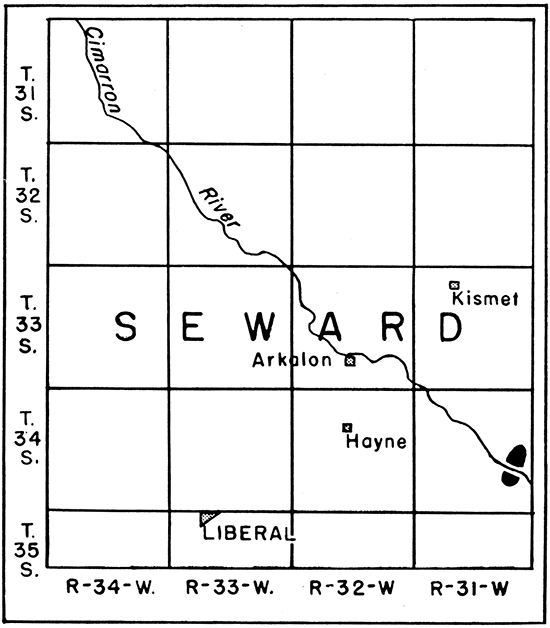
Rock of possible early Pliocene age occurs in one small area in southeastern Seward County (fig. 6), on both sides of Cimarron river in contiguous portions of sections 23, 24, 25, and 26, T. 34 S., R. 31 W. The total outcrop area is slightly more than 1 square mile. The lithology of the rock is unique, and entirely dissimilar to anything else exposed in the region. The beds show irregular easterly dips of 100 or more, and underlie essentially flat beds of the Ogallala with angular unconformity. This rock was observed and described by Adams in 1902, but seemingly has been unnoticed by later geologists.
Figure 6--Map showing location of lower Pliocene (?) beds in southeastern Seward County.
No complete section of these beds was found. The following partial section, however, was measured on the northeast side of the river at the site of a small old quarry:
| Section of Lower Pliocene (?) beds in sec. 24, T. 31 S., R. 34 W., Seward County | Thickness in feet |
|
|---|---|---|
| 8. | Limestone, hard, somewhat porous, white to light sandy | 1 |
| 7. | Sand, very rusty, coarse and gritty below and somewhat clayey above | 7 |
| 6. | Sandstone, soft, massive, coarse-grained, gritty, gray to yellowish, including some grains of limestone | 1 |
| 5. | Chalk, soft, porous, friable, gray to yellowish-gray in color, but weathers gray-buff; shows fine banding but weathers massive. Weathered surface somewhat "case-hardened" by solution and redeposition, Quarried zone | 5.5 |
| 4. | Covered interval | 6 |
| 3. | Chalk, soft, porous, friable, very fine-grained, thinly laminated, somewhat argillaceous, gray to light-chocolate-colored, and somewhat variegated. Some dark fragmentary carbonaceous material on bedding planes | 5 |
| 2. | Covered interval | 5 |
| 1. | Chalk, soft, porous, friable, thin-bedded, light-brownish, clayey, weathers massive; contains some plant remains in lower part, and abundant ostracodes throughout | 7 to 12 |
The base of the section is about 40 feet above river level, the underlying material being concealed. Overlying the section is about 130 feet of Ogallala beds. A few hundred yards to the south, beds of chalk and of limy sandstone, totaling about 5 feet in thickness, are exposed, and seem to be lower in the section. The chalk constitutes the most distinctive part of all the outcrops. It was formerly quarried and sawed into blocks with wood saws for local use in building. It is easily worked, and on exposure becomes superficially hardened by solution and redeposition of calcium carbonate.
Rock similar to that described above was reported by Claude Hibbard, in 1939, from the valley of a tributary to the Cimarron in southwestern Meade County. Similar rock was described also by Cragin (1891) and by Case (1894) from the south side of Beaver river near Beaver, Okla.
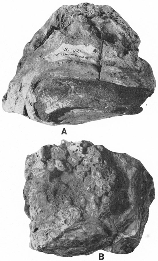
The fine banding (pl. 8B) and uniform lithology of the chalk beds, together with the presence of fresh-water ostracodes and of a fossil fish, reported by residents of the locality, suggest a lacustrine origin. Exact data as to age, however, are wanting. Turtle tracks and bone fragments were found by Adams, and additional fragments were collected by Hibbard and me, but none of these are diagnostic. The ostracodes, now being studied by John R. Embich, may be helpful. If these beds correlate with those near Beaver, Okla., as suggested by Adams, an early Pliocene age would be indicated by the recent studies of Chaney and Elias (1936). In the absence of definite information they are tentatively assigned to that age. It may be mentioned, however, that Adams noted the lithologic similarity of the Seward County beds to the White River Oligocene.
Ogallala Formation
General Relations
The Ogallala formation is a widespread mantle consisting mainly of stream-laid sand, gravel, silt, and minor amounts of clay, all derived principally from the Rocky Mountain region. In places the formation contains small deposits of volcanic ash, and locally there are important limestone beds and some erratic deposits of chert. This mantle is essentially continuous from the Platte valley in Nebraska to the panhandle of Texas, and covers a belt 100 to more than 250 miles wide from west to east. The top of the formation is essentially the surface of the High Plains throughout this region. The formation rests with angular unconformity on older rocks, which, in southwestern Kansas, range from Permian at the east to Upper Cretaceous at the west. The angular discordance is so slight, however, that in many exposures the older and younger rocks seem to be parallel. The thickness of the Ogallala varies with the relief of the underlying topography, and in this area ranges from less than 50 feet to possibly more than 500 feet. In general, the formation is thinner at the east than at the west, but there are also significant differences in thickness from north to south.
Previous Studies
The Ogallala formation, comprising beds previously called "Loup Fork", was named by Darton in 1899 (pp. 734-735, 741-742, pl. 84) from a locality in southwestern Nebraska and its distribution in that state was shown on a generalized map. [Note: In his original description Darton did not specify a definite type locality for the formation, but later (1920 p, 6) referred casually to "the type locality near Ogallala station in western Nebraska." Still later, Elias (in Stirton, 1936, pp. 177-178) proposed to designate a specific type section within the general locality mentioned by Darton.] In 1903 the formation in the Scotts Bluff and Camp Clarke quadrangles in Nebraska was described (Darton 1903, 1903a), and in 1905 its extension across western Kansas and eastern Colorado was mapped and described by Darton (1905, pp. 178-179, pl. 44). In 1935 the vertebrate fauna of the type locality was described by Hesse, and in 1939 recent detailed areal studies in Nebraska were reported by Lugn in a preliminary paper.
Prior to Darton's naming of the formation, beds in southwestern Kansas now classed as Ogallala were described briefly by Hay (1890) and beds in parts of northwestern Kansas were described by the same writer (Hay, 1895). Hay recognized two divisions in these deposits: the "Tertiary grit" below, and "Tertiary marl" above. Two years later, Haworth (1897b) described the general lithology of the Tertiary in western Kansas, and showed that its origin was fluviatile rather than lacustrine as had been assumed by Hay and other previous writers, excepting Gilbert (1896). Johnson (1901) elaborated on Haworth's interpretation, presenting an extended analysis of Tertiary fluviatile deposition, and questioning the validity of Hay's two divisions. After Darton's reconnaissance report of 1905, introducing the name "Ogallala", little further study of this formation was made in Kansas until 1920, when Darton mapped and described in some detail the formation as exposed in the Syracuse and Lakin quadrangles. Later, the Ogallala of Russell county was described by Rubey and Bass (1925), of Ellis and Hamilton counties by Bass (1926), of Osborn county by Landes (1930), of Wallace county by Elias (1931), and of Ness and Hodgeman counties by Moss (1932). The studies of Elias, beginning in 1931, were by far the most detailed, and led to the recognition both of definite horizon markers, and of the value of grass seeds as index fossils (1932, 1935). More recent studies by Theis have as yet been published only in preliminary form (1935).
In eastern Colorado, Tertiary beds now regarded as equivalent to the Ogallala were recognized as fluviatile deposits, and were designated simply as upland sands and gravels by Gilbert in 1896. In 1897, they were given the name Nussbaum formation in a more detailed study of the Pueblo quadrangle. This name was used also by Hills (1899) in describing the geology of the Elmoro quadrangle. Darton (1905) pointed out that this formation corresponded to his Ogallala formation, but he retained Nussbaum in describing the geology of the Arkansas valley in Colorado (Darton, 1906, pp. 34-35). This name was subsequently employed also in the description of the Tertiary strata of the Nepesta quadrangle (Fisher, 1906, pp. 2-3), Apishapa quadrangle (Stose, 1912, p. 7) and several counties in the southeastern part of the state (Coffin, 1921, p. 3; Duce, 1924, p. 91; Patton, 1924, pp. 22-23; Tieje, 1921, pp. 10-11; Toepelman, 1924, p. 12, 1924a, pp. 62-63). On the state geologic map of Colorado (Burbank and others, 1935), however, the greater part of the Tertiary in the Plains region was mapped as Ogallala, and only a few outliers at the west were designated as Nussbaum. The separation of the latter was apparently based on Gilbert's priority for the type locality, but was made arbitrarily, without explanation, and consequently is confusing to the user of the map.
Tertiary beds in the panhandle of Oklahoma corresponding to the Ogallala were described without use of a formation name by Rothrock (1925) and by Gould and Lonsdale (1926). More recently Schoff (1939, p. 57) has definitely referred these beds to the Ogallala.
Beds in the panhandle of Texas equivalent to the Ogallala formation are grouped in the Panhandle formation, a usage to which Hesse (1936, p. 49) objects. A summary of the studies on this formation was made by Plummer in 1932 (pp. 763-776).
Widespread deposits of Ogallala in eastern. New Mexico have been mapped and briefly described by Darton (1928, pp. 58, 300; 1928a). Additional data for Curry and Roosevelt counties are given by Theis (1932).
Paleontological studies, as distinguished from the areal studies listed above, are cited in a later section dealing with the age of the formation.
Lithology
General statement--The lithology of the Ogallala formation is notably variable, both laterally and vertically. With the single exception of a limestone member at the very top of the formation, individual beds are characteristically lenticular, and few can be traced very far. Gravel, sand, clayey silt, and calcium carbonate are the principal materials, but their proportions and degree of induration are typically irregular, and they occur in variable sequence. Beds of one type of material commonly grade into those of another so gradually that no sharp dividing line can be drawn.
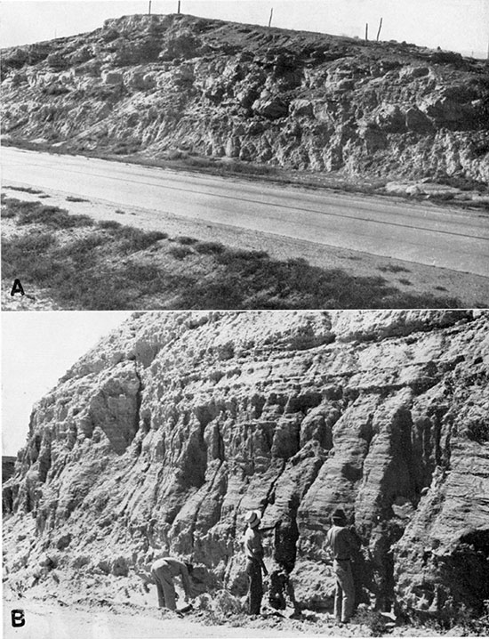
Gravel and conglomerate occur throughout the greater part of the formation, but, in many of the thicker sections, they seem to be coarser, thicker, and more persistent at the base. In many relatively thin sections, no basal gravel is present. The gravel generally is admixed with more or less grit and coarse sand, and commonly grades upward into sand. Channeling (pl. 9A) and cross-bedding are characteristically prominent. The material is generally at least moderately well sorted, and, unless thoroughly cemented, has a relatively great porosity. All gradations are found from loose, uncemented gravel to hard, compact conglomerate, resembling concrete. The former is well represented by the basal beds in Meade and Clark counties, the latter by rock in exposures along Bear creek in western Stanton County. Beds showing an intermediate degree of cementation are perhaps the most common, and constitute the typical "mortar-bed" conglomerate, which generally is easily broken by the hammer. These beds commonly weather in relief, and form prominent ledges along the valley sides. The cementing material is generally calcium carbonate, which in some places is seen to be megascopically crystalline. Limonite is locally conspicuous also. In many outcrops gradation from slight cementation to strong cementation is found, governed seemingly by minor differences in the permeability of beds or cross-laminae. The color of the gravel ranges from dirty gray to rusty brown, the latter being perhaps the more common. In some beds the rusty stain is streaked or spotty, and locally a sooty-black staining is found. The conglomerate beds are generally somewhat dark gray on the weathered surface.
Plate 9--A, Channeling in the Ogallala about 5 miles west of Dodge City. B, Basal Ogallala beds exposed in road cut just cast of Clark County State Lake.
Facies variations--On the basis of the lithology of the pebbles, two distinct facies of gravel are recognizable: one composed dominantly of sandstone, ironstone, and quartzite, and the other of crystalline igneous and metamorphic rocks. The former occurs only at the base of the formation, and is exposed only in Meade and Clark counties. The latter is widespread along the Arkansas valley; and crops out also at scattered localities along the Cimarron valley, above the base of the formation.
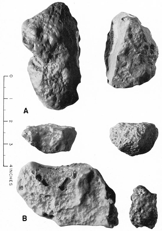
The sandstone-ironstone-quartzite facies is composed mainly of material similar to that found in the Dakota sandstone and other Cretaceous formations. Most of the ironstone pebbles are flat, and are probably concretionary. The sandstone is fine-grained, light buff in color, and more or less saccharoidal in texture. The quartzite is dominantly gray, but weathers rusty brown; it is of the type formed by secondary cementation rather than by metamorphism and recrystallization. Locally some pebbles of gypsum, dolomite, and red sandstone from the Permian are present, and a few mudballs are found. Pebbles of quartz are common, but volcanic rocks are rare and not a single pebble of granite was observed, although some feldspar grains occur in the coarse sand associated with the gravel. In shape, the pebbles range from rounded through subrounded to subangular, the last being almost exclusively quartzite. In size, most of the pebbles do not exceed 3 inches in their longest dimension, but some reach a length of 8 inches, and some sandstone blocks more than a foot long are found. The latter are probably of local derivation. A few ventifacts (pl. 10A) are found among the quartzite pebbles, and are distinguished by their well-smoothed, fine matte surface and shallow, irregular pitting.
Plate 10--Ventifacts: A, From the basal Ogallala gravels in Clark County. B, From Pleistocene (?) beds in southeastern Clark County. Photograph by Bingham.
The granitic facies of the gravel and conglomerate is composed of reddish granite, graphic granite, pink feldspar, quartzite, quartz, several varieties of felsite, and other crystalline igneous and metamorphic rocks. The quartzite ranges from light gray through brown and reddish to black, brown being the most common. The felsite ranges from almost white to reddish and purple. Texturally, it ranges from very fine-grained to aphanitic, and from porphyritic to nonporphyritic. A conspicuous, though by no means abundant variety consists of sparse white feldspar phenocrysts in a very fine-grained reddish-pink matrix. Petrographically, the felsites include varieties of rhyolite, quartz porphyry, syenite, andesite, and probably other rock types. Pebbles of sandstone, ironstone, and chert are also found. The pebbles in this facies are generally well rounded, and few exceed 3 inches in length.
Possibly other facies or subfacies of the gravel and conglomerate may be represented by the deeper, buried portions of the formation, particularly along the Arkansas valley, but few samples of this material have been seen. One, obtained from a water well in Dodge City, at a depth of about 100 feet below river level, is composed mainly of chalky limestone pebbles, but contains a few pebbles of granite and ferruginous sandstone, and coarse grains of quartz and feldspar.
Basalt pebbles were found in very few places, and of these the least equivocal is at Point Rock in western Morton County. There, pebbles of reddish, scoriaceous basalt as much as 5 inches in length occur scattered sparsely through gritty sand in the upper part of the formation. Cobbles of similar material as much as 10 inches in length were found in a gravel bed about 50 feet above stream level on the north side of Crooked creek south of Meade, but it is possible that this bed is post-Ogallala.
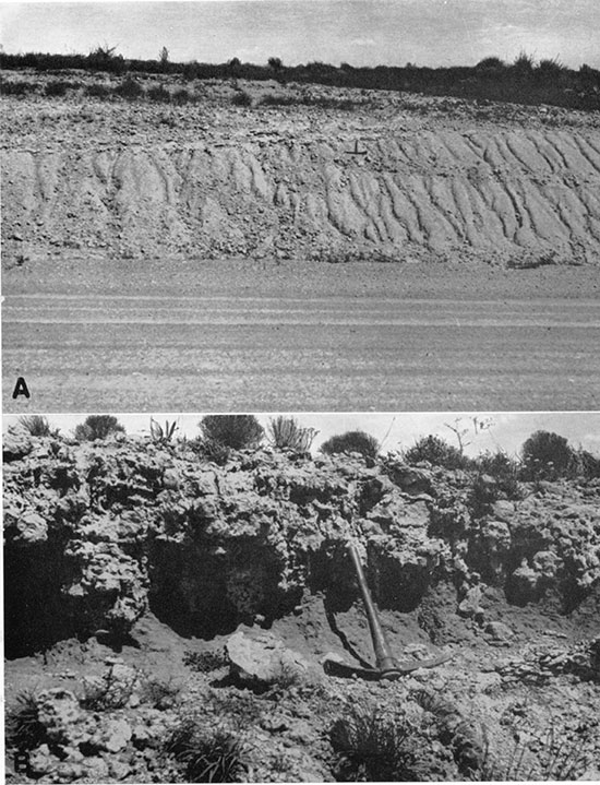
Sand and silt--Sand is the principal material of the Ogallala formation, and occurs at all horizons. It grades into gravel on the one hand, and into sandy, clayey silt and sandy limestone on the other. The sand is composed dominantly of' quartz, but contains a subordinate amount of feldspar and minor amounts of the heavier dark minerals. Texturally, the sand ranges from coarse to very fine grained. The degree of sorting varies. Some beds are clean, uniform, and well sorted (pl. 9B), whereas others are "dirty" and poorly sorted, containing silt and some clay (pl. 11A). Structurally, the sandy deposits range from even-bedded to irregularly cross-bedded, and many layers may be classed as structureless, showing no bedding whatever through a thickness of several feet. The last, in fact, are very common, and are typical of the middle and upper parts of the formation. The structureless layers, in general, tend to be fine grained and poorly sorted, containing admixed silt and minor amounts of clay, and some calcium carbonate. Irregular nodular, knobby, and tubular calcareous concretions are abundant in these layers. The coarser sand, on the other hand, is commonly better sorted, and shows more distinct bedding, but this is not an invariable rule. The cementation of the sand is similar to that of the conglomerate. Calcium carbonate is the principal cementing agent, and as the proportion of lime increases the sand grades from a calcareous sandstone to a sandy limestone. The color of the clean sand is generally gray buff to rusty buff where uncemented, and light gray where the cement is calcareous. Where considerable silt and clay are present in the sand, as in the structureless layers, the color ranges from gray to reddish pink. In a very few places, particularly in the bluff east of Clark County State Lake, a gray-green color was observed in impure sand layers.
Plate 11--A, Fine-grained, calcareous beds near the top of the Ogallala east of Arkalon, in Seward County. B, Caliche bed in the Ogallala at the same locality.
Silt is an important constituent in some of the poorly sorted sandy beds, but was not found to occur in very pure form. Clay likewise occurs principally in mixtures with sand and silt, no beds of true clay being found in the Ogallala formation in this area.
Limestone--Limestone occurs in the Ogallala at many places, but is of subordinate quantitative importance. It is commonest in the upper part of the formation, particularly at the very top, but occurs also at the bottom of some relatively thin sections, as at Point Rock, in Morton County. Exposures are most numerous in Clark County, eastern Meade County, southern Hamilton County, and western Morton County. Limestone beds are medium bedded to massive, and range from about 2 feet to slightly more than 5 feet in thickness. Texturally, they range from soft and chalky to hard, compact, and crystalline, gradations from one extreme to the other being found in a single bed or in closely associated beds. In fresh cuts the limestone is commonly softer than on long-exposed surfaces, suggesting that some "case-hardening" takes place by superficial solution and redeposition. Everywhere it contains scattered grains of sand, sparse in some places, abundant in others. The color on fresh surfaces ranges from light gray buff to reddish buff, the former being the more common. The weathered surface exhibits various shades of gray. More common than limestone proper are beds or zones of "caliche", which characteristically show a very irregular bottom (pl. 11B).
The most persistent and distinctive limestone layer is one that occurs at the top of the formation, and is here referred to as the capping limestone. This limestone has a maximum thickness of about 5 feet, and the upper part generally erodes in relief, forming a prominent ledge. It is commonly massive, and weathers to a knobby, cavernous, or irregular surface. It differs from underlying calcareous beds in degree rather than in kind-s-in greater thickness and hardness, in superior compactness and purity, and in the occurrence, locally, of conspicuous concentric structures. These are made up of concentric, wavy bands differing slightly from the enclosing rock in color or texture, or both (pl. 12B). These structures are etched in relief by weathering. In some the appearance is pisolitic, and in others it suggests algal structure. In a single locality (in the northwestern corner of Harper county, Oklahoma) the concentric structure was found to conform to the outline of a pebble of ferruginous Dakota (?) sandstone (pl. 12A). These structures were observed only in the uppermost part of the capping limestone, and, although common at that level, are locally obscure or absent, and seem to be spotty in their distribution. Inasmuch as these structures have been found only at the very top of those sections of Ogallala in which they occur, they are believed to be diagnostic of the top of the formation. Limestone beds lacking the concentric structures, but otherwise similar to those displaying them, cap exposures of Ogallala in some localities, and are inferred also to mark the original top of the formation.
Plate 12--Concentric structures in the capping limestone: A, In the northwestern corner of Harper County, Oklahoma. B, In southern Hamilton County, in road cut along eastern edge of sec. 8, T. 25 S., R. 42 W. Photograph by Bingham.
The lithology of the capping limestone is remarkably persistent, although wide gaps occur between known exposures. It constitutes the only satisfactory horizon marker in the formation. In southwestern Kansas, outcrops were found in Clark, Meade, Hamilton, and Morton counties. In northwestern Kansas, algal structure is seemingly more prominent in the equivalent horizon, which is referred to by Elias (1931, pp. 136-141) as algal limestone. Beyond the Kansas state line, rock similar to the capping limestone was found by me at the following localities: (1) in the northwest corner of Harper county, Oklahoma, in bluffs east of U. S. highway 283, about 4 miles south of the Oklahoma line, resting directly on Permian redbeds; (2) in Cimarron County, Oklahoma, in a railroad cut north of Boise City, separated from underlying Cretaceous rock only by thin beds of gravel; and (3) along U. S. highway 160 in western Baca county, Colorado, about 4 miles east of the Las Animas county line.
Chert--Some small, irregular bodies of chert, generally of milk-white color, are found in the calcareous beds of the Ogallala, and a single thick bed of chert was discovered in western Clark County, on the south side of U. S. highway 160 in the E2 sec. 9, T. 32 S., R. 25 W. There the chert is about 5 feet thick and seems to be a local variant in the capping limestone, perhaps formed by replacement of the limestone. It forms a prominent white ledge, visible for a considerable distance. The chert is very brittle and easily shattered by the hammer, forming irregular, hackly fragments; seemingly it is thoroughly traversed by incipient fractures. The color ranges from white on the weathered surface to light gray on a fresh surface, and shows some dark mottlings. The rock is megascopically opaque, but contains scattered and irregular clots and veinlets of translucent, opaline silica. The veinlets are locally so prominent as to give the rock a brecciated appearance. Although most of the chert is dense and compact, there are numerous small, irregular tubular openings, marginal to which there are some indications of solution.
Volcanic ash--The Ogallala seems to contain volcanic ash in only one southwestern Kansas locality, in southern Hamilton County (sec. 18, T. 26 S., R. 40 W.). The ash at that place differs from typical Pleistocene ash in its calcareous nature and in a considerably more advanced degree of induration. It is overlain by calcareous sand indistinguishable from that common in the Ogallala.
Areal Description
The bedrock floor--Although lithologic variations are common, indeed characteristic, throughout the Ogallala, they are unsystematic for the most part, and lack any broad regional significance. Of greater interest and importance are the variations in the thickness of the formation, and in the configuration of its bedrock floor, as shown in the cross sections and map, figures 7 and 8. Surface elevations used in preparing these figures were obtained from topographic maps, and my field measurements by altimeter. They are obviously of a lower order of accuracy in parts of the area that are covered only by my reconnaissance contouring than in those for which standard topographic sheets are available. Delineation of the bottom of the Ogallala is based on actual exposures of the contact, as shown on published geologic maps, and on well records. In the greater part of the area the latter provide the only source of information. The degree of confidence with which the bottom of the Ogallala can be recognized in such records depends on two factors: the lithologic contrast between the Ogallala and the underlying beds, and the accuracy and adequacy of the record itself.
Figure 7--Geologic cross-section of the Ogallala formation and associated rocks in southwestern Kansas. Earlier Tertiary beds possibly may be included in sections A and B. Undifferentiated Rexroad beds are included with the Ogallala in section C.
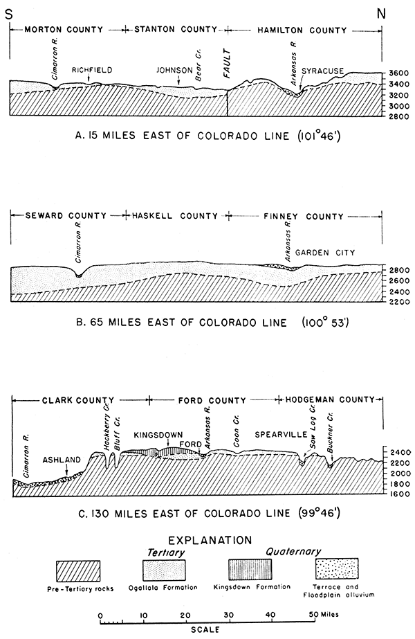
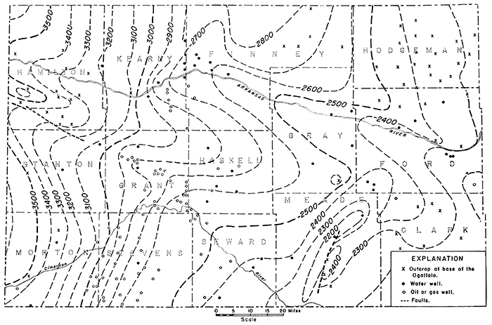
Figure 8--Preliminary contour map of the base of the Tertiary formations in southwestern Kansas. Contour interval 100 feet.
The accuracy of the well log depends first on the type of record that it represents, whether the driller's original log, or a log based on the study of actual samples or cuttings taken from the well. Logs of the latter type are greatly to be preferred, but very few were available in the area studied; these few served to check interpretations resting solely on driller's logs, which are based on the "feel" of the drill, on the rate of penetration, and on inspection of cuttings, sometimes somewhat cursory. The reliability of this type of log varies with the method of drilling, with the purpose of the well, and with the care and experience of the individual driller. Other things being equal, the logs of wells drilled with cable tools are more satisfactory than logs of wells drilled by the rotary method, but the former are in a minority. Water-well logs, on the whole, show far more detail than those of oil and gas wells, particularly with respect to sand and gravel zones, which are of interest as aquifers. Logs of municipal water wells and of deep irrigation wells were found most helpful, but most of these wells failed to reach the base of the Tertiary, and thus gave only a minimum figure for its thickness; unfortunately, no records were available for many wells of this type. Logs of oil and gas wells, although more numerous in some parts of the area, are far less satisfactory. Most of these wells are rotary-drilled, and owing to the speed of drilling and to lack of interest in Tertiary deposits on the part of oil operators, the upper 600 feet is logged only in a very casual fashion. Commonly there are glaring inconsistencies between the logs of near-by wells. Compromises, averages, and approximations are necessary in the interpretation of such records, and the margin of error in estimating the thickness of the Ogallala reaches 100 feet. Finally, it may be noted that the terminology used by drillers is different, and almost never is it the same as that of the geologist. Calcareous beds, for example, are variously referred to as "gyp", "magnesia", or "shells."
The confidence with which the base of the Tertiary may be recognized in well records depends also on the character of the underlying rock. Where this is the shale, limestone, or chalk of post-Dakota formations, the lithologic contrast on entering it is generally well enough marked to attract the driller's attention. This condition prevails over large areas north of Arkansas river. There the Cretaceous beds are commonly logged as blue shale, blue clay, lime, or chalk, as the case may be. Where the color of the "clay" is not indicated, the Ogallala may be inferred to extend to such depth as gravel or coarse sand is reported, and probably to such depth as much sand of any type is interbedded with the clay or shale.
Where the Ogallala is underlain directly by Dakota or pre-Dakota beds, the contact is more difficult to identify, and in many well records can be estimated only very roughly. Where redbeds are first logged, in significant thickness, a post-Permian unconformity is of course indicated, but this may leave a questionable section of considerable thickness below undoubted Tertiary. If gravel or coarse sand is reported in any thickness, however, Tertiary beds are probably indicated to at least the depth at which it occurs, for such material is very rare in the pre-Tertiary beds of this area. This criterion, of course, presupposes that the well log is true to the facts, which in some instances is open to grave doubt, as indicated by conflicting records of different wells in the same locality. Sand or gravel being lacking, estimation of the basal Tertiary contact in any given well log can only be approximated by comparison with the nearest wells for which the records contain more distinctive features, on the assumption that major changes in the bedrock topography are reasonably gradual and orderly. A few wells for which the records seem to have been more carefully made serve as controls on the interpretation of other logs within a considerable radius, and those few wells from which actual samples are available provide the most definitive check of all. Even samples, however, particularly rotary samples, are by no means unequivocal, and must be interpreted with caution. Cuttings from the bottom of the hole may be contaminated with material dropped or carried down from higher levels. Pebbles derived from pre-Tertiary formations are included in Tertiary beds, and, when found in fragmental form mingled with cuttings of other material, easily may be confused with cuttings from the bedrock itself. Pebbles of Dakota ironstone, for example, occur well up in the Ogallala, so that the presence of ferruginous chips in cuttings does not necessarily indicate that the drill has reached the Dakota formation. Nor does the presence of red streaks necessarily indicate that redbeds have been reached, for some beds in the Ogallala are reddish, and probably contain material reworked from the Permian and Triassic.
All factors considered, the data available were hardly adequate, either in quality or in quantity, for accurate contouring of the Tertiary basement. The map is preliminary only, and is subject to such revision as the finding of additional data may require. On the whole, however, it is believed to present a true, though generalized picture of the major features of bedrock topography.
The bedrock floor, as mapped, is obviously not to be regarded as a normal erosional topography. Crustal deformation is believed to have played an important role, and to have taken place partly before or during the deposition of the Ogallala, and partly after the deposition of that formation. Evidence for this is discussed in the section on structural geology. It may be noted also that the bedrock surface does not necessarily represent the base of the Ogallala in all places. It is entirely possible that, where depth to the bedrock floor is considerably greater than the "normal" thickness of the Ogallala, the latter is underlain by older Tertiary formations, and that it is these that rest directly on the bedrock.
Variations in the western area--A more detailed description of the Ogallala and its areal variations is given in following pages. This description is based on division of the area into three broad, north-south-trending belts, centering roughly about the three cross sections (fig. 7); these are discussed in order from west to east.
At the western edge of the area, near the Colorado line, the base of the Ogallala (or of the Tertiary) has a relief of more than 250 feet, and the thickness of the formation ranges from 50 feet to more than 200 feet. The noteworthy features here are two buried valleys or basins separated by a ridge (fig. 7A). Evidence for these is found mainly in the areal maps of Darton (1920) and Bass (1926). The north valley corresponds in position to the present valley of Arkansas river. At the west, the bottom of the old valley, as reconstructed, lies above the modern valley level. Eastward it seems to become somewhat shallower and to converge with the present valley level, but toward the eastern border of Hamilton County data are inadequate and the relations are obscure, so that the old valley cannot be traced with certainty into Kearny County.
North of the Arkansas valley, data on the floor of the Ogallala are very meager. Beyond the evidence of several inliers of Cretaceous rocks along short tributary streams, and of a single well record, contours are drawn on the basis of interpolation to a few water-well logs in Greeley county. The record of the well, in Hamilton County, located about 6 miles north of Kendall, is of interest, and is quoted from Haworth (1897b, pp. 261-262):
| Record of well 6 miles north of Kendall, Kansas | Thickness in feet |
Total depth |
|---|---|---|
| Soil and light-colored subsoil | 8 | 8 |
| Clay with large amount of calcareous cement | 6 | 14 |
| Sand and gravel | 57 | 71 |
| Sandy clay with much calcareous cement | 28 | 99 |
| Sand and coarse gravel | 6 | 105 |
| Sandy clay | 25 | 130 |
| Sand and gravel | 12 | 142 |
| Yellow sand | 13 | 155 |
| Sand and gravel | 9 | 164 |
| Clay | 6 | 170 |
| Water-bearing sand and gravel | 22 | 192 |
| Yellow clay and fine sand | 4 | 196 |
A thickness of at least 192 feet is indicated for the Ogallala, placing the base of the formation at a lower level than in the river bluff at Kendall, due south.
South of the Arkansas valley, the bedrock surface rises abruptly to a ridge, which marks a structural dome in the Cretaceous beds. Here the Ogallala thins to 50 feet or less. An outcrop of the capping limestone was found along a road cut in the E2 sec. 8, T. 25 S., R. 42 W., and it seems probable that this limestone controls the present plateau. The bedrock ridge declines eastward, with the topographic surface, but adequate controls for its delineation toward and beyond the Kearny County line are wanting.
In southern Hamilton County and northern Stanton County, south of the ridge, the Ogallala seems to occupy a broad basin. According to Darton's interpretation of the log of a well at Johnson (1920, p. 9), the Ogallala there reaches a thickness exceeding 180 feet. To the southwest and south, the bedrock floor gradually rises, to crop out along shallow stream valleys in southwestern Stanton County and northern Morton County. In southern Morton County it declines again. At Point Rock, on the river bluff about 6 miles east of the Colorado line, the thickness of Ogallala beds is 80 feet, and the section is as follows:
| Section of Ogallala beds at Point Rock on Cimarron river, 6 miles east of the Colorado state line | Thickness in feet |
|
|---|---|---|
| Tertiary system, Ogallala formation: | ||
| 6. Calcareous beds, poorly exposed | 8 to 10 | |
| 5. Calcareous sandstone to sandy limestone, containing some sand lenses and numerous vertical, rod-like concretions | 8 | |
| 4. Calcareous sandstone, irregularly cemented and more or less massive | 6 | |
| 3. Calcareous sand, structureless, gray-buff, gritty, with scattered limy concretions and pebbles of reddish scoriaceous basalt as much as 5 inches in length. | 10 | |
| 2. Poorly exposed interval, mostly soft sandy material | 42 | |
| 1. Gray limestone, weathering cavernous to platey | 4 | |
| Unconformity | ||
| Sandstone of Mesozoic age | ||
| Total thickness | 78 to 80 | |
The base of the section is 53 feet above river level; it is underlain by Mesozoic sandstone. The Ogallala beds are slightly warped.
Farther south, at Elkhart, the thickness of the Ogallala formation is at least 250 feet. A representative section is recorded in the log of Elkhart city well No. 5:
| Record of well at Elkhart, Kansas, showing Ogallala beds | Thickness in feet |
Total depth |
|
|---|---|---|---|
| Dirt | 3 | 3 | |
| [Tertiary system, Ogallala formation] | |||
| Sandy clay | 15 | 18 | |
| Sandy clay with "gyp" | 22 | 40 | |
| "Gyppy" clay | 5 | 45 | |
| Sand | 9 | 54 | |
| "Gyppy" clay | 16 | 70 | |
| Plain "gyp" | 16 | 86 | |
| "Gyp" and clay | 12 | 98 | |
| "Gyp" | 24 | 122 | |
| "Gyp" and clay | 14 | 136 | |
| Sandy clay | 18 | 154 | |
| "Gyp" | 4 | 158 | |
| "Gyp" and clay | 5 | 163 | |
| Sandy clay | 9 | 172 | |
| Red clay with little sand | 16 | 188 | |
| Red joint clay | 4 | 192 | |
| Pack sand with few boulders | 33 | 225 | |
| Pack sand and clay, larger percent clay | 20 | 245 | |
| Sand and gravel | 5 | 250 | |
| [? Unconformity] | |||
| [? Permian system or Mesozoic] | |||
| Brown pack sand | 7 | 257 | |
| Red sandy clay | 8 | 265 | |
| Pink sand rock | 12 | 277 | |
| Light-yellow sand rock | 9 | 286 | |
| Red shale | 1 | 287 | |
The sand and gravel at a depth of 245 to 250 feet must be Tertiary, and the material below is probably pre-Tertiary. Examination of samples from depths of 246 to 277 feet in test hole No. 4 for Elkhart city well No. 7 confirmed the above interpretation, showing sand of typical Ogallala lithology to a depth of 258 feet. This sand is fine to medium grained, angular, buff, dominantly quartzose and subordinately feldspathic, and at a depth of 246 to 250 feet contains a few small pebbles. A distinct red color is first observed at a depth of 272 feet. The sand at a depth of 258 to 272 feet is somewhat finer and more nearly uniform than that above, and contains some silt. All or part of it may be of Mesozoic age. East of Elkhart, toward Stevens County, the bedrock floor declines and the thickness of the Tertiary strata increases rapidly.
Variations in the central area--The Tertiary attains its maximum thickness in the central part of the area (fig. 7B). Here the bedrock topography shows two basins separated by a broad divide. The basin at the north reaches its maximum depth of 300 feet below the present Arkansas valley level in the vicinity of Garden City. Inasmuch as some previous workers have assumed that the deposits underlying the Arkansas valley are all Quaternary alluvium, it is desirable to review briefly the evidence for Tertiary age of the greater part of the fill. (1) The bedrock floor of the Ogallala plunges under the Arkansas valley near Hartland in Kearny County. (2) Just east of the point noted, the bedrock floor steepens too abruptly to be accounted for by normal stream erosion alone (fig. 8). (3) Well records in western Finney County and eastern Kearny County, at places some miles distant from the present valley, show Ogallala similar in composition and in thickness to the material under the Arkansas valley. (4) From central Kearny County to Ford County, two water-bearing zones separated by relatively impervious "clay" are reported along the Arkansas valley. The "first" water, in the upper 25 to 35 feet of fill, is distinctly harder than that at greater depth. This suggests two separate and independent aquifers having different intake areas. The upper of these is obviously Quaternary valley fill. The lower one can be only Ogallala.
Eastward, the bedrock depression--or Finney basin--becomes a buried valley coinciding approximately with the Arkansas valley as far as the town of Ford, gradually becoming shallower toward that point. Westward, between Deerfield and Hartland, it shallows abruptly, and, near the latter locality, emerges from the river alluvium. Typical are the following well records from Garden City and Lakin.
| Record of Railroad Well No. 4 at Garden City, Kansas | Thickness in feet |
Total depth |
|
|---|---|---|---|
| [Quaternary and Tertiary deposits, undifferentiated] | |||
| Loam | 8 | 8 | |
| "Arkansas river bed" | 44 | 52 | |
| Yellow clay | 7 | 59 | |
| Sand and gravel | 29 | 88 | |
| Yellow clay | 9 | 97 | |
| Red sand and gravel | 25 | 122 | |
| Clay | 1 | 123 | |
| Fine sand | 8 | 131 | |
| Yellow clay | 7 | 138 | |
| Black sand | 7 | 145 | |
| Sand and water | 10 | 155 | |
| Clay | 1 | 100 | |
| Quicksand and water | 29 | 185 | |
| Coarse sand and gravel | 17 | 202 | |
This well stops far short of bedrock, for Darton (1905, p. 298) reports that a deeper well encountered "quicksand" to a depth of 311 feet, and entered black shale below that depth.
| Record of Railroad Well No. 4 at Lakin, Kansas | Thickness in feet |
Total depth |
|
|---|---|---|---|
| [Quaternary and Tertiary deposits, undifferentiated] | |||
| Loam | 8 | 8 | |
| "Arkansas river bed" | 24 | 32 | |
| Yellow clay | 3 | 35 | |
| Blue sand | 83 | 118 | |
| Blue clay | 7 | 125 | |
| Coarse dark sand | 8 | 133 | |
| Blue sand | 5 | 138 | |
| Blue clay | 8 | 146 | |
| Coarse red sand | 4 | 150 | |
| Yellow sand and gravel | 20 | 170 | |
| Yellow clay | 7 | 177 | |
| Yellow sand and gravel | 21 | 198 | |
| Red sand and gravel | 16 | 214 | |
| Yellow sandy clay | 3 | 217 | |
| Coarse sand and gravel | 14 | 231 | |
| [? Unconformity] | |||
| [? Pre-Tertiary] | |||
| Rock | |||
The significance of the "blue" sand and clay recorded in the Lakin well is not clear.
North of the Arkansas valley, the Finney basin extends into Scott County, and is continuous with the Shallow Water basin of that county. Evidence for this is based partly on well records and partly on the surface topography, which has the form of a broad, asymmetrical depression (pl. 2). This depression is traversed by no stream, has no surface drainage, and obviously could have been formed only by areal subsidence, which presumably affected the bedrock in equal degree. In southern Scott County, about 3 miles north of the county line, an oil-well log for the deeper part of the trough gives the following record:
| Partial record of a well in sec. 14, T. 20 S., R. 33 W., Scott County, Kansas | Thickness in feet |
Total depth |
|
|---|---|---|---|
| [Quaternary and Tertiary deposits, undifferentiated] | |||
| Surface clay | 50 | 50 | |
| Sand | 40 | 90 | |
| Gravel and sand | 35 | 125 | |
| [Unconformity] | |||
| [Cretaceous system] | |||
| Shale and "shells" | 65 | 190 | |
| Lime | 35 | 225 | |
| Lime and shale | 100 | 325 | |
This suggests that the thickness of the Ogallala is 125 feet. Another well in the same section, however, gives the contact between sand and gravel and blue shale at 182 feet.
On the western flank of the Finney basin, in Kearny County about 9 miles north of Deerfield and just west of the Finney County line, a representative well log is as follows:
| Partial record of a well in sec. 25, T. 22 S., R. 35 W., Kearny County, Kansas | Thickness in feet |
Total depth |
|
|---|---|---|---|
| [Quaternary and Tertiary deposits, undifferentiated] | |||
| Soil | 19 | 19 | |
| Fine sand | 53 | 72 | |
| No. 10 sand | 10 | 82 | |
| No. 9 sand | 20 | 102 | |
| No. 8 sand | 28 | 130 | |
| Clay | 12 | 142 | |
| No. 8 sand | 15 | 157 | |
| No. 9 sand | 6 | 163 | |
| No. 8 sand | 11 | 174 | |
| Clay | 10 | 184 | |
| Coarse gravel | 22 | 206 | |
| [Unconformity] | |||
| [Cretaceous system] | |||
| Clay | 21 | 227 | |
| Blue shale | 75 | 302 | |
This indicates a thickness of 206 feet for the Ogallala.
In northeastern Finney County, the Cretaceous-Ogallala contact crops out along the valley of Pawnee creek. Here the Ogallala is generally less than 100 feet thick.
South of the Arkansas valley, the bedrock surface rises more than 200 feet to form a broad swell in northern Haskell County and adjoining counties at the east and west. The overlying sediments thin to 200 feet or less. Evidence for this bedrock divide is found partly in well records studied by Darton. At the now-abandoned town of Santa Fe, in central Haskell County, Darton (1920, pp. 5, 6) reports 226 feet of Ogallala on the basis of a well log not quoted in full. The surface elevation here is about 120 feet higher than at Garden City. Ten miles northwest of Santa Fe, however, only 42 feet of Ogallala is reported (Darton, 1905, p. 303); the log is as follows:
| Record of a well 10 miles northwest of Santa Fe, Haskell County, Kansas | Thickness in feet |
Total depth |
|
|---|---|---|---|
| Soil | 3 | 3 | |
| [Tertiary system, Ogallala formation] | |||
| Tertiary grit | 42 | 45 | |
| [Unconformity] | |||
| [Cretaceous system] | |||
| Blue clay (Benton) | 260 | 305 | |
| Hard blue rock | 20 | 325 | |
| Sand with much water rising to 210 feet | 5 | 330 | |
One-half mile south of Santa Fe, Darton (1920, p. 5) reports a thickness of 286 feet for the Ogallala, and 6 miles southwest of the same place a thickness of only 180 feet. Logs are not quoted. The second figure indicates either a local high or an error in the original log or in its interpretation. In view of these uncertainties and of disagreement with other data, this figure was rejected in constructing the bedrock contour map.
Eastward, the bedrock divide continues into Gray County, and, in the southeastern township of that county, Cretaceous limestone crops out. At Montezuma, in the south-central part of the same county, a thickness of 224 feet in indicated for the Ogallala (and overlying Quaternary material) by the log of the railroad well:
| Record of railroad well at Montezuma, Gray County, Kansas | Thickness in feet |
Total depth |
|
|---|---|---|---|
| [Quaternary and Tertiary deposits, undifferentiated] | |||
| Soil | 4 | 4 | |
| Brown clay | 10 | 14 | |
| Dark clay | 9 | 23 | |
| Soft rock | 10 | 33 | |
| Hard sand rock | 53 | 86 | |
| Soft sand | 3 | 89 | |
| Soft sand rock | 65 | 154 | |
| Sand and clay | 13 | 167 | |
| Soft sand | 3 | 170 | |
| Gravel and clay | 6 | 176 | |
| Gravel, clay, and sand | 22 | 198 | |
| Soft sand | 3 | 201 | |
| Gravel, clay, and sand | 12 | 213 | |
| Concrete gravel | 0.5 | 213.5 | |
| Sticky clay | 0.5 | 214 | |
| Concrete gravel | 1 | 215 | |
| Sticky clay | 0.5 | 215.5 | |
| Concrete gravel | 0.5 | 216 | |
| Blue shale | 1 | 217 | |
| Concrete gravel | 1 | 218 | |
| Blue shale | 4 | 222 | |
| Concrete gravel | 1 | 223 | |
| Blue shale | 0.5 | 223.,1 | |
| Gravel | 0.5 | 224 | |
| [Unconformity] | |||
| [Cretaceous system] | |||
| Blue shale | 92 | 316 | |
This well is probably on the northern flank of the subsurface divide. The upper 23 feet may represent loess or the Quaternary Kingsdown formation or both.
Westward in Grant County, the bedrock divide seems to flatten out, but data are inadequate. At a water well in Ulysses, gravel is logged at a depth of 263 to 268 feet, indicating Ogallala to at least that depth, and suggesting a position south of the bedrock arch. The complete log is as follows:
| Record of a well at Ulysses, Grant County, Kansas | Thickness in feet |
Total depth |
|
|---|---|---|---|
| [Quaternary and Tertiary deposits, undifferentiated] | |||
| Soil and sand | 35 | 35 | |
| Clay | 5 | 40 | |
| Sand | 28 | 68 | |
| Clay | 66 | 134 | |
| Fine sand | 23 | 157 | |
| Sandy clay | 18 | 175 | |
| Good sand | 7 | 182 | |
| Dirty sand | 2 | 184 | |
| Fine sand, nice and clean | 6 | 190 | |
| Dirty sand | 11 | 201 | |
| Fine sand | 6 | 207 | |
| Sandy clay | 13 | 220 | |
| Hard, tough clay | 5 | 225 | |
| Dirty sand | 9 | 234 | |
| Tough clay | 29 | 263 | |
| Gravel | 5 | 268 | |
| [? Unconformity] | |||
| [? Cretaceous system, Dakota] | |||
| Good sand | 25 | 293 | |
Six miles north of Ulysses, Darton (1920, p. 5) reports the Ogallala to be 212 feet thick; this point is probably farther up on the south flank of the bedrock arch. Six miles south-southeast of Ulysses (sec. 36, T. 29 S., R. 37 W.), Darton (1920, p. 6; 1905, pp. 299-300) cites a well log that also indicates 212 feet of Ogallala. This points to a local, secondary bedrock high, separated from the main arch to the north by a depression of uncertain extent and outline.
Farther south, in Stevens and Seward counties, a broad and ill-defined basin occurs, in which the Tertiary reaches its maximum thickness of more than 500 feet (Johnson, 1901, p. 628). This basin extends also a considerable distance into Texas County, Oklahoma (Schoff, 1939, fig. 3). It is entirely possible that the Tertiary section in this area includes a considerable thickness of pre-Ogallala beds) conceivably including Eocene or Oligocene deposits. Only by the recovery of identifiable fossils, however, could this be demonstrated satisfactorily.
Water wells at Satanta, in southwestern Haskell County, lie in the northern edge of the basin. The log for the railroad well is as follows:
| Record of the railroad well at Satanta, Haskell County, Kansas | Thickness in feet |
Total depth |
|
|---|---|---|---|
| [Quaternary and Tertiary deposits, undifferentiated] | |||
| Surface material | 10 | 10 | |
| Hard rock | 5 | 15 | |
| Dark gray clay | 15 | 30 | |
| White clay | 20 | 50 | |
| Coarse dry sand | 50 | 100 | |
| Fine dry sand | 30 | 130 | |
| Sandy clay | 45 | 175 | |
| Cement gravel | 10 | 185 | |
| Sand and gravel | 15 | 200 | |
| Coarse sand, water-bearing below 220 ft | 45 | 245 | |
| White clay | 13 | 258 | |
| Blue clay | 2.5 | 260.5 | |
| Coarse water-bearing sand | 49.5 | 310 | |
| [? Unconformity] | |||
| [? Pre-Tertiary deposits] | |||
| Hard yellow clay | 1 | 311 | |
This suggests a thickness of at least 310 feet for the Tertiary (and undifferentiated Quaternary) deposits.
Data on the thickness of the Tertiary at Liberal, in southern Seward County, are particularly good. The log for the deepest of the three city wells (center well in park), is as follows:
| Record of city well at Liberal, Seward County, Kansas | Thickness in feet |
Total depth |
|
|---|---|---|---|
| [Quaternary and Tertiary deposits, undifferentiated] | |||
| Soil, clay loam, and dry sand | 200 | 200 | |
| Good sand | 17 | 217 | |
| Sandy clay | 62 | 279 | |
| Hard shell | 2 | 281 | |
| Good sand | 18 | 299 | |
| Rock | 1 | 300 | |
| Hard shell | 6 | 306 | |
| Sand | 18 | 324 | |
| Sandy clay | 31 | 355 | |
| Very hard rock | 3 | 358 | |
| Clay and sand, sticky | 20 | 378 | |
| Tough clay | 21 | 399 | |
| Very good coarse sand | 7 | 406 | |
| Clay | 19 | 425 | |
| Sand | 8 | 433 | |
| Clay | 15 | 448 | |
| Good sand | 48 | 496 | |
| Clay, and perhaps sand in last foot | 6 | 502 | |
No pre-Tertiary rocks are identifiable in the records of the water wells at Liberal. Consequently, it seems that Quaternary and Tertiary deposits are exceptionally thick in this district. A sample of sand reported to have been taken from a depth of 337 to 347 feet in the test hole for the new irrigation well in the northwest corner of Liberal was examined by me in the office of the City Engineer. It was found to be a coarse, granitic sand or grit, of the type common in the Ogallala. The sand from the bottom of the well logged above was reported by the City Engineer to be similar in character. In the record of another well at Liberal, quoted by Darton (1905, pp. 316-317), coarse sand and gravel is logged at a depth of 445 to 485 feet. From these facts it is concluded that the Tertiary (and undifferentiated Quaternary) deposits have a thickness of approximately 500 feet in the vicinity of Liberal.
In west-central Seward County, the following gas-well log indicates a thickness of 380 feet for the Tertiary:
| Record of a well in the SW sec. 33, T. 32 S., R. 34 W., Seward County, Kansas | Thickness in feet |
Total depth |
|
|---|---|---|---|
| [Quaternary and Tertiary deposits, undifferentiated] | |||
| Quicksand (20-in. casing set at 366 ft.) | 380 | 380 | |
| [Unconformity] | |||
| [? Permian system] | |||
| Shale, blue | 35 | 415 | |
| Shale, light | 32 | 447 | |
| Red rock, hole caving | 3 | 450 | |
| Red shale | 140 | 590 | |
| Red rock | 167 | 757 | |
Farther north, a somewhat greater thickness is indicated by other wells.
Near Arkalon, in central Seward County, a water well for the Panhandle Eastern "booster" station was logged as follows.
| Record of well near Arkalon, Seward County, Kansas | Thickness in feet |
Total depth |
|
|---|---|---|---|
| [Quaternary and Tertiary deposits, undifferentiated] | |||
| Top soil, sandy clay, and loam | 14 | 14 | |
| Dry sand | 13 | 27 | |
| Clay | 7 | 34 | |
| Fine sand, dry | 4 | 38 | |
| Tough clay | 25 | 63 | |
| Dry sand | 8 | 71 | |
| Blue clay | 4 | 75 | |
| Sandy clay | 11 | 86 | |
| Soft sand rock | 6 | 92 | |
| Sand, water-bearing | 11 | 103 | |
| Blue clay | 9 | 112 | |
| Soft sand rock | 2 | 114 | |
| Good water-bearing sand | 21 | 135 | |
| Blue clay | 4 | 139 | |
| Fine sand | 7 | 146 | |
| Blue clay | 3 | 149 | |
| Good sand and gravel | 19 | 168 | |
Along the west side of a tributary draw a few hundred yards east of this well, the following section (beds 1-5) was measured, its base being about 50 feet higher than the floor of the well. Overlying beds (6-8) were studied on the east side of the valley.
| Section of Ogallala beds near Panhandle Eastern pump station, Arkalon, Kansas | Thickness in feet |
|
|---|---|---|
| Tertiary system, Ogallala formation | ||
| 8. Sand, calcareous, containing concretionary nodules | 25 | |
| 7. Sand, calcareous, silty, containing limy concretions, capped by a hard, resistant layer of caliche (pl. 11) | 35 | |
| 6. Covered interval | 35 | |
| 5. "Mortar bed", massive, moderately well cemented | 5 | |
| 4. Sand, cross-bedded, soft, yellowish; a fragment of rhinoceros tusk found in the lower part | 9 | |
| 3. Sand, hard, well cemented | 5 | |
| 2. Sand, unconsolidated, gritty | 6 | |
| 1. Sand, coarse, gritty, pebbly, cross-bedded, slightly consolidated, containing some mud balls | 8 | |
The section is overlain by dune sand. The total measured thickness for the Tertiary is 346 feet, and this is minimum.
In Stevens County, the most convincing evidence for the thickness of the Tertiary 'was found in a series of samples collected by me as a gas well was being drilled near the southwestern corner of the county. One composite sample was collected for each length of drill pipe (average length about 30.5 feet) between the depths of 79 and 627 feet. The sample log is as follows:
| Partial record of a well in sec. 34, T. 34 S., R. 38 W., Stevens County, Kansas, based on study of samples | Thickness in feet |
Total depth |
|
|---|---|---|---|
| [Quaternary and Tertiary deposits, undifferentiated] | |||
| Sand, silt and clay, mostly soil | 18 | 18 | |
| Clean, medium to coarse sand | 61 | 79 | |
| Dirty, dark-buff, fine to medium sand and light, gray-buff, compact limestone | 30 | 109 | |
| Limestone chips; medium to coarse sand and grit | 61 | 170 | |
| Ditto, plus pebbles as much as 0.3 in. long | 31 | 201 | |
| Coarse sand, grit, calcareous sandstone, limestone chips, and pebbles of quartz and crystalline rocks as much as 0.5 in. long | 30 | 231 | |
| Similar to above, but some reddish staining | 31 | 262 | |
| Similar to above, but virtually no reddish color; gray clay toward bottom | 30 | 292 | |
| Medium to coarse dirty sand, a few pebbles, and some chips of clay | 31 | 323 | |
| Grit, pebbles, and clay | 30 | 353 | |
| Similar to above, but sandier | 31 | 384 | |
| Similar to above, but containing calcareous, clayey buff silt | 61 | 445 | |
| Dirty, clayey grit, chips of red mudstone, and some pebbles | 30 | 475 | |
| Similar to above, but sandier, and containing more red material | 31 | 506 | |
| Dirty, reddish sand and grit, some chips of clay | 30 | 536 | |
| Sand and grit, clayey in part; a few chips of reddish material | 30 | 566 | |
| Dirty, reddish sand grit, and a few small pebbles | 31 | 597 | |
| [Unconformity, possibly at slightly higher position] | |||
| [Permian system] | |||
| Light reddish sand and silt | 30 | 627 | |
This log is interpreted to indicate a thickness of about 580 feet for the Tertiary. The driller's log of the same well is given below for comparison:
| Driller's record of upper part of well in sec. 34, T. 34 S., R. 38 W., Kansas | Thickness in feet |
Total depth |
|
|---|---|---|---|
| Sand and clay | 595 | 595 | |
| Shells | 32 | 627 | |
| Sand, clay, and shells | 373 | 1000 | |
| Redbeds and gyp rock | 70 | 1070 | |
In the town of Hugoton, a test hole for the municipal well reached a depth of 308 feet, and seemingly ended within the Tertiary. The log is as follows:
| Record of a well at Hugoton, Stevens County, Kansas | Thickness in feet |
Total depth |
|
|---|---|---|---|
| [Quaternary and Tertiary deposits, undifferentiated] | |||
| Soil | 2 | 2 | |
| Clay | 6 | 8 | |
| Sandy clay | 10 | 18 | |
| Clay | 6 | 24 | |
| Sandy clay | 7 | 31 | |
| Fine sand | 11 | 42 | |
| Sandy clay | 4 | 46 | |
| Packed sand | 35 | 81 | |
| Coarse sand and gravel | 17 | 98 | |
| Clay | 3 | 101 | |
| "Gyp" and clay | 11 | 112 | |
| Sandy clay | 12 | 124 | |
| Clay and "gyp" | 10 | 134 | |
| "Gyp" | 6 | 140 | |
| Sandy clay | 12 | 152 | |
| Fine packed sand | 8 | 160 | |
| Clay | 40 | 200 | |
| "Gyp" | 5 | 205 | |
| Clay | 4 | 209 | |
| Rock | 2 | 211 | |
| Packed sand | 4 | 215 | |
| Rock | 1 | 216 | |
| "Gyp" | 2 | 218 | |
| Clay and "gyp" | 30 | 248 | |
| Coarse sand and gravel | 6 | 254 | |
| Clay, sand, and gravel | 13 | 267 | |
| Rock | 2 | 269 | |
| Clay | 4 | 273 | |
| Sandy clay | 30 | 303 | |
| Rock | 1 | 304 | |
| Clay | 4 | 308 | |
Eight miles east and two miles south of Hugoton (sec. 26, T. 33 S., R. 36 W.), the Heger irrigation well reached a depth of 360 feet without entering bedrock. A sample of the material from the bottom of this well that was shown to me was identified as typical Tertiary grit and gravel.
Elsewhere in Stevens County, gas-well logs indicate depths to bedrock ranging from about 400 to 600 feet. It is possible that some Dakota or other pre-Tertiary rock is represented in some of these, but if present it is probably thin, and in no case is it certain. Typical gas-well logs available for study are quoted below.
| Partial record of a well in sec. 3, T. 31 S., R. 37 W., Stevens County, Kansas | Thickness in feet |
Total depth |
|
|---|---|---|---|
| [Quaternary and Tertiary deposits, undifferentiated] | |||
| Gravel | 170 | 170 | |
| Sand | 280 | 450 | |
| Gravel | 60 | 510 | |
| [? Pre-Tertiary rocks] | |||
| Clay, yellow | 15 | 525 | |
| Red rock and clay | 455 | 980 | |
| Partial record of a well in sec. 2, T. 33 S., R. 39 W., Stevens County, Kansas | Thickness in feet |
Total depth |
|
|---|---|---|---|
| [Quaternary and Tertiary deposits, undifferentiated] | |||
| Sand | 72 | 72 | |
| Sand and yellow clay | 100 | 172 | |
| Sand and gravel | 162 | 334 | |
| Sand and sand rock | 20 | 354 | |
| Sand, hard | 19 | 373 | |
| Sand | 67 | 440 | |
| [? Pre-Tertiary rocks] | |||
| Redbeds | 20 | 460 | |
| Redbeds and shells | 167 | 627 | |
| Partial record of a well about 8 miles south of Hugoton in sec. 27, T. 34 S., R. 37 W., Stevens County, Kansas | Thickness in feet |
Total depth |
|
|---|---|---|---|
| [Quaternary and Tertiary deposits, undifferentiated] | |||
| Sand and clay | 40 | 40 | |
| Clay and sand | 250 | 290 | |
| Water sand | 32 | 322 | |
| Sand and gravel | 238 | 560 | |
| [? Pre-Tertiary rocks] | |||
| Redbeds | 40 | 600 | |
| Partial record of a well southeast of Hugoton in sec. 23, T. 33 S., R. 37 W., Stevens County, Kansas | Thickness in feet |
Total depth |
|
|---|---|---|---|
| [Quaternary and Tertiary deposits, undifferentiated] | |||
| Sand | 40 | 40 | |
| Sand, gravel, red clay | 250 | 290 | |
| Sand and shells | 300 | 590 | |
| [? Pre-Tertiary rocks] | |||
| Redbeds | 118 | 708 | |
The difficulties in distinguishing between Cretaceous and Tertiary strata in such logs are obvious. Where gravel is reported down to the redbeds, however, the absence of Cretaceous rocks is suggested. Individually, the logs are far from satisfactory, and there is a large margin of error in drawing contacts. Collectively, however, they show sufficient rough agreement to outline a subsurface basin in which the thickness of the Tertiary rocks far exceeds the average for the rest of the High Plains region in Kansas.
The bedrock basin seems to become shallower eastward, and it ends against the Meade trough, an elongate bedrock depression that is entirely discordant with, general regional trends, and corresponds in position with the Crooked creek valley. Its origin is discussed in the section on structural geology. On the east side of Crooked creek south of Meade, the redbeds crop out in two places (secs. 9 and 32, T. 33 S., R. 28 W.), not shown on the state geologic map (Moore and Landes, 1937). They are overlain by a section of Ogallala of "normal" thickness. Eight miles south of Meade, the following section was measured:
| Section of Quaternary and Tertiary deposits 8 miles south of Meade, Kansas | Thickness in feet |
|
|---|---|---|
| Quaternary system | ||
| 13. Silt, light-brownish, loess-like, clayey, containing limy nodules | 9 | |
| ? Unconformity | ||
| 12. Mudstone, greenish-gray, calcareous, containing some caliche in irregular layers and scattered knobs | 16 | |
| 11. Volcanic ash | 2 to 6 | |
| 10. Mudstone like No. 12 | 8 | |
| ? Unconformity | ||
| Tertiary system, Ogallala formation | ||
| 9. Sand and grit, reddish-buff, some small pebbles, mainly granitic, and layers and scattered nodules of caliche; fossil seeds of Biorbia fossilia near base | 30 | |
| 8. Limestone, sandy, moderately hard, grayish | 3 | |
| 7. Sand, light-buff, massive, calcareous | 5 | |
| 6. Limestone, sandy, moderately hard | 2 | |
| 5. Sand, fine, light gray-buff, calcareous | 7 | |
Beds 10 to 13 are believed to be Quaternary. The lower part of the section was measured about 0.25 mile west, in a gravel pit by the side of the creek, using bed 5 as a local horizon marker:
| Section of Tertiary deposits at gravel pit about 8 miles south of Meade, Kansas | Thickness in feet |
|
|---|---|---|
| Tertiary system, Ogallala formation | ||
| 7-9. Sand, silty, buff to reddish, limy, including some gray layers | 18+ | |
| 6. Sandstone, hard, calcareous | 1 | |
| 5. Sand, light gray-buff, calcareous, fine | 5 | |
| 4. Limestone, sandy; some sand and caliche | 6 | |
| 3. Sand, gray to reddish, calcareous | 10 | |
| 2. "Mortar bed" sandstone, pebbly, to gritty | 0.5 to 10 | |
| 1. Sand, coarse, loose, cross-bedded, and gravel; pebbles dominantly of brown and black sandstone, subordinately of quartzite and volcanic rock; some mud balls and a few ventifacts | 30 | |
| Total thickness of Ogallala | 103 feet | |
The underlying bedrock is not exposed at this point, but from outcrops a few miles north and south, and from the presence of large red pebbles and mud balls in the basal gravels, it is inferred to lie at shallow depth. The basal gravel in this section is among the coarsest found anywhere in undoubted Ogallala, containing some cobbles as much as 8 inches long. In the valley bottom just west of the bluffs in which the above section is exposed, wells are reported to reach depths of 200 feet without encountering the redbeds, indicating an abrupt drop in the bedrock floor.
In contrast to the moderate thickness of Ogallala deposits in the measured section 8 miles south of Meade are the much greater thicknesses of unconsolidated material logged in the Meade and Fowler municipal water wells. Well No. 1 at Meade showed gravel at a depth of 229 to 239 feet, and the bottom may possibly be post-Cretaceous rock, at a depth of 283 feet. The Fowler well ended in gravel at a depth of 285 feet, indicating that the bedrock floor had not been reached. The log is as follows:
| Record of water well at Fowler, Kansas | Thickness in feet |
Total depth |
|
|---|---|---|---|
| [Quaternary and Tertiary deposits, undifferentiated] | |||
| Soil and clay | 21 | 21 | |
| Fine dry sand | 4 | 25 | |
| Sandy clay | 28 | 53 | |
| Blue sand | 15 | 68 | |
| Blue sandy clay | 92 | 160 | |
| Yellow sandy clay | 8 | 168 | |
| Fine sand | 4 | 172 | |
| Good sand | 8 | 180 | |
| Clay | 5 | 185 | |
| Sand | 7 | 192 | |
| Clay | 2 | 194 | |
| Sand | 10 | 204 | |
| Hard sand rock | 4 | 208 | |
| Streaks of sand and clay | 16 | 224 | |
| Hard "gyp" | 1 | 225 | |
| Sand, fine and "quicky" | 31 | 256 | |
| Clean fine sand | 20 | 276 | |
| Gravel | 9 | 285 | |
Logs of wells in the southwestern township of Ford County (Lohman, 1938, pp. 9-10) indicate Tertiary rocks to depths of 210 feet.
On the west side of the Meade trough, only a partial record for' one deep well was obtained. This well is located about 5 miles' southeast of Plains (sec. 2, T. 33 S., R. 30 W.). Sand and gravel are logged at a depth of 1?5 to 283 feet, and "chocolate-colored shale" from 283 to 292 feet. Examination of a sample from that interval, supplied by Paul Reusser, showed only a dirty, silty sand typical of the Ogallala. At Plains, the municipal water well was reported to be 365 feet deep, but no log was on file. Inasmuch as the Ogallala is the principal aquifer in this area, it is a reasonable supposition that the bottom of this well is within the Tertiary. Although outcrop and well-log data are meager and spotty, the presence of artesian water in large areas along Crooked creek valley constitutes additional evidence of a structural trough in the bedrock surface.
Character in the eastern area--In the eastern part of the area, the Ogallala becomes much thinner, and the discernible irregularities of its floor are less marked (fig.7C). The zone of maximum thickness coincides approximately with the present Arkansas valley. At Dodge City, a depth of 160 feet to bedrock is indicated by the following log of a well located 300 feet east of the water works and ice plant.
| Record of a well near the water works at Dodge City, Kansas | Thickness in feet |
Total depth |
|
|---|---|---|---|
| [Quaternary and Tertiary deposits, undifferentiated] | |||
| Soil | 3 | 3 | |
| Sand containing water | 27 | 30 | |
| Yellow clay, soft, impermeable | 10 | 40 | |
| Water-bearing sand | 40 | 80 | |
| Yellow clay and sand | 10 | 90 | |
| Fine sand and quicksand, water | 60 | 150 | |
| Coarse, clean gravel, water | 10 | 160 | |
| [Unconformity] | |||
| [Cretaceous system and? Permian] | |||
| Black, mucky clay, sticky and impermeable | 20 | 180 | |
| Black shale | 40 | 220 | |
| Yellow sand and sand rock, about 8 to 10 inches of "coal" at bottom | 20 | 240 | |
| White sand rock, water | 15 | 255 | |
| Dark sandstone | 10 | 265 | |
| Black, mucky clay | 10 | 275 | |
| Red rock | 50 | 325 | |
The upper 30 feet is probably Quaternary valley fill. Eastward, in the vicinity of Ford, irrigation wells studied by, H. A. Waite indicate that the Ogallala is approximately 70 feet thick under the Arkansas valley. Cretaceous rock crops out at several places on the north side of the valley in this locality, however, and it is probable that these wells are on the side rather than on the center of the pre-Ogallala valley. The following well log from southeastern Ford County indicates that the buried valley diverges from the topographic valley in eastern Ford County, and continues southeast where the latter swings to the northeast.
| Record of a well in sec. 22, T. 29 S., R. 21 W., Ford County, Kansas | Thickness in feet |
Total depth |
|
|---|---|---|---|
| [Quaternary system, Kingsdown formation] | |||
| Surface and clay | 46 | 46 | |
| Clay | 64 | 110 | |
| [Tertiary system, Ogallala formation] | |||
| Sand and gravel | 10 | 120 | |
| Water sand | 81 | 201 | |
| Sand and gravel | 59 | 260 | |
| [Unconformity] | |||
| [Cretaceous and older rocks] | |||
| Sticky shale | 80 | 340 | |
| Sand | 92 | 432 | |
| Shale and redbeds | 28 | 460 | |
If this log is accurate, the depth to bedrock is 260 feet. The upper 110 feet represents the Quaternary Kingsdown formation. It is interesting to note that Darton (1920, p. 3) recognized this probable divergence of the buried and the surface valleys, for he writes:
From Hartland to Dodge the base of the [Ogallala] formation descends below the bottom of Arkansas river and probably occupies an old depression, which continues eastward through Kiowa and Pratt counties and the western part of Reno county.
The upper part of the Ogallala crops out at many places in the bluffs on the north side of the Arkansas valley, and the basal contact is widely exposed, along Sawlog creek, Buckner creek, and Pawnee river. The thickness is nowhere very great, the following section from the railroad well at Spearville being representative:
| Partial record of railroad well at Spearville, Ford County, Kansas | Thickness in feet |
Total depth |
|
|---|---|---|---|
| [Quaternary and Tertiary deposits, undifferentiated] | |||
| Black soil | 6 | 6 | |
| Brown clay | 14 | 20 | |
| White "gyp" rock | 72 | 92 | |
| Coarse water sand | 9 | 101 | |
| [Unconformity] | |||
| [Cretaceous system] | |||
| Yellow sandy clay | 5 | 106 | |
| Black sticky shale | 6 | 112 | |
| Light-blue sticky shale | 30 | 142 | |
| Light-blue clay | 22 | 164 | |
| Fine gray sand, little water | 3 | 167 | |
| Coarse gravel, little water | 4 | 171 | |
| Dark-blue clay | 13 | 184 | |
The well continues to a depth of 389 feet, in clay and shale for the greater part of the section .. The "coarse" gravel from 167 to 171 feet is unusual, for such material is very rare in the Cretaceous section. A thickness of 101 feet is indicated for the Ogallala and undifferentiated younger deposits. A sample from the bottom of one of the Spearville city wells, at a depth of 85 feet, that was shown to me is typical Cretaceous rock.
Farther north, in Hodgeman and Ness counties, Moss (1932, pp.13- 15) reports that the Ogallala is about 100 feet thick at the west and thins eastward. The bedrock floor (pl. 2) seems to slope somewhat north of east, but, data are inadequate, the elevations here being obtained from contour maps to which geological boundaries were transferred from the map by Moss and from the state geologic map.
South of the Arkansas valley, the base of the Tertiary does not crop out until the upper stretches of Bluff creek are reached. There, in the northern edge of Clark. county, inliers of Cretaceous (not shown on the state geologic map) are found in the N2 sec. 25, T. 30 S., R. 24 W., and N2 sec. 22, T. 30 S., R. 23 W. Where Bluff creek bends south, the Ogallala is thin and locally absent, so that upper Pliocene and Pleistocene beds rest directly on the Cretaceous. It is uncertain whether this is due to the presence of hills on the pre-Ogallala surface or to post-Ogallala erosion. It is possible that the bedrock surface was never entirely covered by the Ogallala. Near Minneola, in the northwestern part of Clark County, the following well log (Moore and Haynes, 1917, p. 252) indicates that the depth to bedrock is about 125 feet.
| Record of a well in the SE sec. 10, T. 30 S., R. 25 W., near Minneola, Clark County, Kansas | Thickness in feet |
Total depth |
|
|---|---|---|---|
| [Quaternary and Tertiary deposits, undifferentiated] | |||
| Soft black soil | 5 | 5 | |
| Yellow, clayey shale | 75 | 80 | |
| Gray sandstone | 41 | 121 | |
| Yellow "gyp" | 4 | 125 | |
| [Pre-Tertiary rocks] | |||
| Soft red rock | 5 | 130 | |
| Soft blue shale | 143 | 273 | |
The upper 80 feet probably represents the Quaternary Kingsdown formation, and it is possible that some Rexroad beds are present below that formation.
In the bluffs on both sides of Bluff creek at Clark County State Lake the Ogallala is well exposed.
| Section of Ogallala beds on the west side of Clark County State Lake | Thickness in feet |
|
|---|---|---|
| Tertiary system, Ogallala formation | ||
| 6. Limestone, caps bluff | 5 | |
| 5. Calcareous bed, massive, porous | 4 | |
| 4. Calcareous bed, nodular, somewhat soft | 5 | |
| 3. Sandstone, calcareous, hard, massive, cavernous | 3 | |
| 2. Sand, a lenticular bed, soft, coarse, uniform buff, containing fossil seeds of Biorbia fossilia | 3 | |
| 1. Sand, uniform, fine, light buff, harder and more calcareous toward top where casts of fossil plant stems seem to be present | 13 | |
| Total thickness of Ogallala | 33 feet | |
The section is underlain by Cretaceous shale. Fresh exposures in a road cut show that calcareous beds appearing gray on well-weathered surfaces tend to be light buff on fresh surfaces. On the east side of the valley, the thickness is slightly greater, and some gray-greenish sand and mudstone is present at the base (pl. 9B). The capping limestone is overlain by 40 feet of brownish-buff silty sand of the Kingsdown formation.
In central Clark County, on a high hill in the NW sec. 11, T. 32 S., R. 22 W., the following section is exposed. It does not extend to the base of the Ogallala formation.
| Section of Ogallala beds in sec. 11, T. 32 S., R. 22 W., central Clark County | Thickness in feet |
|
|---|---|---|
| Tertiary system, Ogallala formation | ||
| 5. Sandstone, calcareous, grading up into sandy limestone; weathers irregular to cavernous and platy; some vague casts of plant roots or stems in places; seeds of Biorbia fossilia in lower 5 feet | 20 | |
| 4. Sand, medium-grained, clean, loose, buff-colored | 10 | |
| 3. Sand, gray-brown, mottled, silty, fine, containing numerous scattered limy concretions | 7 | |
| 2. Sand, light-buff, fine, calcareous toward top | 6 | |
| l. Sand and gravel, mostly covered | 20+ | |
| Exposed thickness of Ogallala | 63 feet | |
On the whole, the thickness of the Ogallala in the southeastern part of the area is nowhere very great, and just south of the state line the capping limestone rests directly on the Permian redbeds. On the east rim of Big Basin, in western Clark County, the section is as follows:
| Section of Ogallala and underlying beds in the N2 sec. 25, T. 32 S., R. 25 W., Clark County, Kansas | Thickness in feet |
|
|---|---|---|
| Tertiary system, Ogallala formation | ||
| 6. Limestone, soft to hard, locally cherty | 5 | |
| 5. Sand, buff, containing calcareous nodules | 3 | |
| 4. Limestone, hard, sandy | 5 | |
| 3. Sandstone, soft, massive, light-buff, calcareous, fine-grained | 10 | |
| 2. Sand, gray, very concretionary | 5 | |
| 1. Gravel and coarse sand grading upward into clean, uniform finer sand; some ventifacts; sand arkosic but pebbles are all of ironstone, sandstone, quartzite, and quartz | 22 | |
| Total thickness of Ogallala | 50 feet | |
| Pre-Tertiary beds | ||
| Gray-buff shale | 5 | |
| Black shale | 8 | |
| Fine-grained light-buff sandstone | 10 | |
| Redbeds | 54 | |
Ventifacts (pl. 10A) are common in the lower part of the Ogallala formation in the southeastern part of the area, but have not yet been found in other districts, perhaps because exposures are less adequate. In addition to the localities noted above, ventifacts have been found in the E2 sec. 10 and W2 sec. 18, T. 32 S., R. 22 W., and the S2 sec. 17, T. 32 S., R. 21 W. Characteristic also of the formation in this part of the area is the virtual absence of granite and other crystalline rocks (except quartzite) from the basal gravel.
Age and Correlation
The Ogallala is undifferentiated in Darton's original description (1899, pp. 732, 734) and its age is listed as late Tertiary, or Pliocene (?). Osborn (1909, pp. 79-80) later distinguished and dated two zones in the formation: (1) Procamelus zone, of late Miocene age, and (2) Peraceras zone, representing the last phase of the Miocene or the first phase of the Pliocene. The latter zone was regarded as representing the typical Ogallala. Still later, Osborn (1918, pp. 23-27) modified this dating, and listed the following zones: (1) Procamelus-Hipparion zone, of late Miocene or early Pliocene age, and (2) Peraceras-Pliauchenia zone, of early Pliocene age, including the typical Ogallala. In 1933, Simpson (p. 104), in a general discussion of Tertiary formations, referred to the Ogallala as a "general name for later Tertiary of the central Great Plains, for the most part of lower Pliocene age." In 1935, Hesse studied the vertebrate fauna from the type locality" of the Ogallala in Keith county, Nebraska, and assigned to it a middle Pliocene age. [Note: In his original description Darton did not specify a definite type locality for the formation, but later (1920 p. 6) referred casually to "the type locality near Ogallala station in western Nebraska", Still later, Elias (in Stirton, 1936, pp. 177-178) proposed to designate a specific type section within the general locality mentioned by Darton.] Stirton, in 1936, in a more comprehensive treatment, presented definitive faunal evidence for the recognition of lower, middle, and upper divisions of the Pliocene, and listed the following faunas from the Pliocene of the Great Plains:
| Pliocene vertebrate faunas of the Great Plains | |
|---|---|
| Upper Pliocene | |
| Texas: Crosby County, Blanco fauna | |
| Middle Pliocene | |
| Nebraska: Keith County, Feldt Ranch fauna | |
| Kansas: Phillips County, (?) Long Island fauna; Sherman County, Edson fauna; Wallace County, Rhinoceros Hill fauna, (?) Collins Draw fauna, (?) Lost Quarry fauna; Rooks County, (?) Rooks fauna. | |
| Colorado: Yuma County, Wray or Beecher Island fauna | |
| Oklahoma: Texas County, Optima fauna | |
| Texas: Armstrong County, Goodnight fauna; Hemphill County, Hemphill fauna; Lipscomb County, Higgins fauna | |
| Lower Pliocene | |
| South Dakota: Todd County, Little White River fauna, Oak Greek fauna; Bennett County, Big Spring Canon fauna. | |
| Nebraska: Cherry County, Burge fauna; Brown County, (?) Devil's Gulch fauna; Sheridan County, (?) Pine Creek fauna; Sioux County, Upper Snake Creek fauna (mixed, includes some Miocene) | |
| Kansas: Phillips County, Long Island fauna (in part) | |
| Colorado: Logan County, Upper Pawnee Creek fauna | |
| Oklahoma: Beaver County, Beaver fauna | |
| Texas: Donley County, Clarendon fauna | |
Of these faunas, all except the Pine Creek and Upper Snake Creek are referred by Stirton to the Ogallala as interpreted by Elias (in Stirton, 1936, pp. 177, 178). The relations of the Blanco fauna to the Ogallala, however, are controversial.
A paleobotanical approach to the zoning and dating of the Ogallala was presented by Elias in a preliminary paper in 1935. In this paper, and in another published the next year (Chaney and Elias, 1936), it was shown that certain fossil plant seeds are of wide occurrence and of short vertical range, thereby providing a satisfactory bass for stratigraphic zoning. The correlation of these seed zones with mammalian faunas of established age was briefly indicated, and the value of the seeds as guide fossils made clear. Further studies in this direction are soon to be published in full by Elias.
The latest contribution to the study of the Ogallala was made by Lugn in 1939, on the basis of investigations in western Nebraska. He proposed that Ogallala be redefined as a group name to include the following four mappable formations, provisionally dated as indicated: (1) Valentine formation (lower Pliocene), (2) Ash Hollow formation (middle Pliocene), (3) Sidney gravel (upper Pliocene), (4) Kimball formation (very late upper Pliocene). Although complete descriptions of these formations and criteria for their differentiation are as yet unpublished, it may be inferred from the preliminary discussion that the subdivision is based primarily on the succession of fossil seeds, and secondarily on lithology and stratigraphic relations.
In the light of the foregoing, the age relations of the Ogallala in southwestern Kansas may now be considered. Vertebrate fossils are few and far between in this area, but such as have been found point to middle Pliocene age, as defined by Stirton (1936). First may be mentioned the fragment of a rhinoceros tusk found by me in the section just east of Arkalon in Seward County (p. 62). Although closer identification of this material was impossible, the very presence of rhinoceros remains suffices to indicate an age not later than middle Pliocene. A second fossil locality occurs in Clark County about 9 miles north of Ashland (NE sec. 27, T. 31 S., R. 23 W.). A fairly large quarry was opened at this place by Sternberg in recent years, presumably for the Frick laboratory in New York. The one specimen thus far described from this locality was identified by Hesse (1935) as Capromeryx altidens and is believed to be of middle Pliocene age. A third fossil locality lies in the bluffs on the east side of Bluff creek at Clark County State Lake (SE sec. 25, T. 30 S., R. 23 W.). At this locality I found numerous fragments, but no identifiable material. It was reported that many good specimens had been taken out by workers from the near-by CCC camp, and had been either lost, carried away, or destroyed. No other localities were found in the area studied. Very significant, however, is the Optima fauna of Texas County, Oklahoma, at a point about 17 miles south of the Kansas state line. Extensive collections of middle Pliocene fossils have been made there by Stovall in beds similar to and presumably continuous with those of Kansas (Schoff, 1939, pp. 61-62).
Also indicative of middle Pliocene age are fossil seeds of Biorbia fossilia from the following localities (identifications by M. K. Elias):
| Localities from which fossil grass seeds (Biorbia fossilia) have been collected | |
|---|---|
| Clark County | |
| W2 sec. 25, T. 30 S., R. 23 W. (bluffs on west side of State Lake), see section, p.-. | |
| NW, sec. 18, T. 32 S., R. 22 W. (on west side of county road 5 miles north of Ashland); seeds occur in a 2-foot calcareous bed 32 feet below the top of a 74-foot section. The base of the section is concealed and the top has probably been lowered by erosion. | |
| Sec. 11, T. 32 S., R. 22 W. (Mt. Jesus locality, northeast of Ashland), see section, p. -. | |
| Meade County | |
| S2 sec. 16, T. 33 S., R. 28 W. (east side of Crooked creek 8 miles south of Meade), see section, p. -. | |
The Ogallala elsewhere in the area seems to be continuous with the beds in which fossils have been found, and its lithology is essentially similar. It is therefore concluded that the Ogallala of southwestern Kansas, insofar as it is represented by exposures at the surface, may be assigned to middle Pliocene age. The locally overlying Rexroad formation, of late Pliocene age, is unconformable on the Ogallala, and is not to be regarded as a part of that formation. The underlying chalky beds of southeastern Seward County, provisionally designated as lower Pliocene (?), may possibly constitute a focal variant within the Ogallala, but until more specific evidence on this point is forthcoming, their dissimilar lithology and angular discordance with typical overlying Ogallala provide adequate reason for regarding them as an earlier and distinctly separate deposit.
Correlations with the Nebraska section are uncertain. Pending the publication of Lugn's complete results, and the completion of detailed studies in. the intervening area, it would be premature to attempt any exact correlation with the Nebraska section. The one type of fossil grass seed thus far found in southwestern Kansas, Biorbia fossilia, occurs throughout three of Lugn's divisions. It is true that Lugn's description of the uppermost division of the Tertiary, the Kimball formation, suggests similarity to the capping limestone of southwestern Kansas, but if his provisional assignment of this formation to the very late upper Pliocene is accepted, possibility of this correlation is eliminated, for the capping limestone of the Kansas area is believed to antedate the upper Pliocene Rexroad formation, described elsewhere in this report.
Indeed, it is doubtful whether the Ogallala section of southwestern Kansas is susceptible to any very definitive subdivision. Good exposures are far apart, the exposed thickness is much less than in Nebraska, and fossils are few. It is possible that all the events so well recorded in the Nebraska section are telescoped into a much smaller vertical interval, but it is possible on the other hand that local Pliocene history in these two widely separated areas has been different in detail, so that depositional units are discontinuous, and do not closely correspond in time. In fact, I am more impressed by the variability of the formation, both lateral and vertical, than by any degree of lithologic constancy (with the single exception of the capping limestone). This is in agreement with the reports of well drillers, who commonly make many test holes prior to drilling any large well, and find a marked lack of correspondence between holes only a few hundred feet apart. In the light of these considerations, it is deemed advisable to retain the term Ogallala as no more than a formation name, in the sense originally proposed by Darton, insofar as the area under discussion is concerned.
The age of the Ogallala relative to that of the extensive basaltic lavas of southeastern Colorado and northeastern New Mexico is of some importance in the interpretation of volcanic detritus in sedimentary deposits of uncertain age occurring in this region. Darton (1906, p. 36) stated that--
on the south side of the Mesa de Maya the basalt is seen to overlie an outlier of later Tertiary gravels, which indicates that the age is post-Pliocene.
Lee (1922, pp. 8, 13) questioned Darton's evidence, but, on general physiographic grounds, accepted Quaternary age for the lavas farther west, in the Raton district. Later, however, Rothrock (1925, p. 72) confirmed Darton's dating, reporting that the lava on Black mesa, in the northwestern corner of Cimarron County, Oklahoma, is underlain by upper Tertiary sand and gravel, presumably equivalent to the Ogallala. In the summer of 1939, in company with members of the U. S. Geological Survey, I found additional confirmation of post-Ogallala age for the lava. On the north side of Carrizo mesa, near the Baca-Las Animas county line in Colorado, several tens of feet of typical Ogallala calcareous sandstone was found between the Dakota sandstone and the basalt. No basaltic detritus was observed in the Ogallala, nor any indication of proximity to active vulcanism. From the foregoing it may be concluded that the basalt flows nearest Kansas are definitely of post-Ogallala age. On the other hand, it may be noted that pebbles of basaltic scoria were found in more or less typical Ogallala deposits of the Point Rock section in western Morton County, and that basaltic pebbles were found in the formation also in Cimarron County, Oklahoma (Rothrock, 1925, p. 61). It is entirely possible that the outpouring of extensive plateau basalts was the climax of a volcanic history that began much earlier. Mertie (in Lee, 1922, p. 10), in fact, has suggested a long and complex volcanic history for Sierra Grande, in northeastern New Mexico. Lee (1922, fig. 7) has pointed out that lavas of several different ages are present in the Raton district. It is very probable that the earliest of these lavas antedates the basalt on mesas farther east, and also antedates the Ogallala. If Hill's correlation of certain gravel beds near Trinidad with the Nussbaum formation is correct (1899, p. 2 and maps), this supposition is confirmed, for the gravels lie more than 2700 feet below the lava on the mesas about 5 miles south.
Origin of the Formation
Scope of the problem--Although at first thought to be a lacustrine deposit (Hay, 1890, Williston, 1895), the Ogallala was early shown to be of fluviatile origin (Gilbert, 1896; Haworth, 1897b; Johnson, 1901). In the light of present knowledge, the Ogallala may be described as a warped and dissected piedmont alluvial plain deposit. It is not to be regarded as a composite fan deposit as supposed by some workers, however, for its thickness increases away from the mountain front, whereas that of a fan deposit decreases outward from a point near its apex. In the following pages I propose to outline the origin of the Ogallala in some detail, in the light of new facts that have gradually become known since the publication of Johnson's monograph in 1901. No claim for finality is made, but it is hoped that this synthesis will aid further critical studies. The following questions are discussed in order: (1) significance of climate, (2) source of material, (3) paleophysiography, (4) mode and progress of deposition, (5) cause of deposition, (6) origin of the capping limestone, and (7) correlation with events in the Rocky Mountain area.
Significance of climate--The climate of Ogallala time may be inferred either from the physical characteristics of the deposits themselves, or from their flora and fauna, particularly the flora. Johnson (1901, chap. 2, esp. pp. 628-632) based his conclusions entirely upon the former. Reasoning deductively in the light of analogies with conditions in the Great Basin, he interpreted the environment of deposition as having been essentially of the desert type, and implied that the climate was more arid than at present. The presence of abundant calcium carbonate in the formation was accepted as supporting evidence. Recent paleobotanical studies by Chaney and Elias (1936) lead to a different conclusion. Detailed analysis of the ecological relations of a flora from lower Pliocene beds in Beaver County, Oklahoma, supplemented by study of the vertebrate fauna, was found to indicate a temperature somewhat warmer than now, and a rainfall about 10 inches greater than at present. From similar studies of a middle Pliocene flora in Logan County, Kansas, it was concluded that the rainfall of that time was about 5 inches greater than that in the same area today, although about 5 inches less than that in Oklahoma in early Pliocene time. The presence of fossil grass seeds in the Ogallala at many other places provides further evidence that the climate was far from a desert type.
Source of materials--The materials of the Ogallala were derived mainly from the Rocky Mountain region. Pebbles of igneous and metamorphic rocks are predominant in the gravel beds, except for certain beds at the base. Quartz and reddish feldspar, such as are derived from the disintegration of granitic rocks, are prominent in the sandy beds. Some material probably of less distant origin is found, however, in basal gravels. This includes Cretaceous limestone (Arkansas valley), sandstone, ironstone, and quartzite of Dakota aspect (Meade and Clark counties), and Permian redbeds material (Meade County). Detailed tracing of lithologic types to source areas seems to be entirely feasible, but has not yet been undertaken.
The origin of the abundant calcium carbonate in the Ogallala is less obvious. The widespread occurrence of Cretaceous limestone and chalk in eastern Colorado at once suggests a possible source. The proportion of calcareous material, however, is greatest in the upper part of the formation, which must have been deposited after the Cretaceous rocks to the west were almost covered. Furthermore, if the Cretaceous of the Plains were an important source, it would be expected that the lime content of the Ogallala would show significant meridional variations from north to south, according to the lithology of the beds exposed between the mountains and the present outcrop area. No such variations have been observed. Finally, if the Cretaceous beds of eastern Colorado contributed dissolved calcium carbonate to the waters that deposited the Ogallala, it might be expected that they would have contributed also some recognizable fragmental material. That such material has not been found in the upper part of the formation constitutes negative evidence against the postulate. From these considerations, it is concluded that the transported calcareous matter in the Ogallala originated mainly, if not only in the Rocky Mountain area from weathering of Paleozoic limestone and of calcic minerals in the crystalline rocks. Additional lime may have been provided also by weathering in situ after deposition.
Similar considerations apply to the silt and disseminated clay in the Ogallala formation. Conceivably these too might have been derived from the Cretaceous shales of eastern Colorado, but This material is relatively more abundant in the upper part of the formation, which must have been deposited when the shale areas were at least partly covered, and it fails to show the meridional variations expected on the postulate of a Cretaceous source. Furthermore, the principal source of sediment must have coincided with the belt of maximum rainfall, which lay in the mountain area, rather than with the belt of minimum rainfall in the plains area. Thus the silt and clay of the Ogallala are best explained as having been derived from soils and weathering products in the mountain area, some minor additions resulting from the comminution of coarser materials during transportation.
Paleophysiography--Prior to deposition of the Ogallala, there was extensive erosion of older formations. Structures were beveled, more than 1,000 feet or rock was carried away, and, at the east, the entire Cretaceous section was stripped off. This erosion took place intermittently, and there were intervening periods of deposition, represented now by the Oligocene and Miocene deposits of the plains area. The greater part of this erosion was probably effected by through-going streams from the mountains, but streams heading in the plains may also have been important then as now. The material removed during these periods of erosion was probably carried to the Gulf Coast region, where lie the nearest early and middle Tertiary deposits.
At the close of pre-Ogallala time, a widespread erosion surface extended from the Rocky Mountain front eastward to central Kansas. This surface beveled rocks ranging from Permian at the east to Eocene at the west. It was probably composite in character, and comprised the products of more than one cycle of erosion. In the Kansas area, it was by no means a perfect peneplain, but was characterized by considerable local relief, probably more than 200 feet (compare Johnson, 1901, p, 627). The bedrock contour map at the base of the Tertiary (fig. 8), although suggestive, does not represent a true picture of the pre-Ogallala topography. A part of the present bedrock relief is a result of warping and subsidence that took place during or after the deposition of the Ogallala beds. This applies particularly to the Meade trough, the Finney basin, and perhaps also to the basins in Stanton County, and in Stevens and Seward counties. It is possible also that certain of the bedrock valleys and basins antedated the Ogallala, but had been partly filled with older sediments before deposition of the Ogallala rocks began.
The broad, regional relations of the pre-Ogallala surface may be inferred in part from data summarized in the physiographic map, figure 9. On this map it may be observed that the north-south relief of the sub-Ogallala surface gradually increases from east to west. Nearest the mountains, this surface shows a broad arch or divide, corresponding to the present Platte-Arkansas divide, and having a north-south relief of about 1,500 feet. South of the Arkansas valley, the inferred extension of the sub-Ogallala surface rises steadily to or against a second broad upland in southern Colorado and northern New Mexico. These relations suggest two queries: Were the main drainage outlets from the mountains in Ogallala time the same as they are today, and do the present bedrock highs in front of the mountains represent pre-Ogallala highs of corresponding position and relief? The answer to the first of these questions is difficult. Certainly there must have been drainage outlets from the interior of the mountain area. The volume of Ogallala sediments obviously derived from crystalline rocks is far too great to be accounted for by the mere wearing back of the mountain front, which, so far as the crystalline rocks are concerned, could never have been appreciably farther east than its present position, as shown by structural relations. Of existing streams, only the Platte and the Arkansas penetrate far enough into the mountain interior to answer requirements of Ogallala sedimentation. Fenneman (1931, p. 110) believes that the gap where Arkansas river emerges from the mountains antedates the last uplift, which implies that it was in existence in Ogallala time. Recent studies by Powers (1935) confirm the persistence of the Arkansas drainage since pre-glacial time, but leave some doubt as to the Pliocene history of the river. Conclusions justified by available facts are mainly negative. There are no reasons for doubting the persistence of the principal drainage outlets from intermontane areas since Ogallala time, or for assuming that they were then more numerous than at present. More positive conclusions must await detailed studies on the locus and magnitude of post-Ogallala mountain uplift.
Figure 9--Physiography of the Ogallala formation. Contour interval 1,000 feet. Stippled areas represent the Ogallala formation. Areas in solid black represent mountain ridges and peaks above 10,000 feet, and crosshatched areas indicate mountainous areas at lower altitude.
In formulating an answer to the question as to the antiquity of the Platte-Arkansas divide, several possibilities must be considered: (1) that the pre-Ogallala surface had about the same slope and relief as the present sub-Ogallala surface, and has since been modified only by uniform tilting toward the mountains and by erosion; (2) that the pre-Ogallala surface was much flatter than the present surface of the High Plains, had negligible north-south relief, and acquired its present configuration as a result of strongly differential post-Ogallala warping; (3) that inferences as to the true subOgallala surface are invalidated by incorrect mapping and correlation of the formation in eastern Colorado. Concerning the last of these possibilities, it must be observed that no adequate description of the beds mapped as Ogallala in eastern Colorado has yet been published, and that I have no first-hand acquaintance with them. On the other hand, there is no real reason for questioning the mapping in that area, and the topographic surface on the beds in question is certainly continuous with that on undoubted Ogallala beds farther east. This possibility is accordingly dismissed.
The implications of the first (1) of the suggested possibilities--the persistence of a high, bedrock divide throughout Ogallala and post-Ogallala time-may now be considered. This is the hypothesis accepted by Fenneman (1931, p. 35). It requires one of two alternatives: (a) that the divide was completely buried by an essentially level deposit of Ogallala materials, laid down principally by the through-going streams corresponding to the Platte and Arkansas, and having a maximum thickness equal to the north-south relief, about 1,500 feet; or (b) that the deposits on the crest and flanks of the bedrock arch were deposited in their present thickness by a stream of streams issuing from the mountain front at the apex of the divide. The first of these alternatives (a) presents insurmountable difficulties. The present thickness of the Ogallala along the Arkansas valley near the mountain front is nowhere reported to exceed 100 feet. Furthermore, the surface of the formation closely parallels its base, which is easy to explain on the basis of a tilted depositional surface, but extremely difficult to explain as a result of erosional planation of an originally thicker deposit The second alternative (b) merits more careful consideration, but quickly it is seen to encounter serious objections: The west-east slope is notably steeper along the Platte-Arkansas divide than along the valley of either river. It is difficult to picture conditions permitting the deposition of sediments having similar lithology and thickness by different streams haVing gradients so strongly contrasted. No streams of significant length issue from the mountain front at the apex area of the Platte-Arkansas divide today, and there is no reason for assuming that the drainage lines of Ogallala time were different in this respect. If any stream did issue from the mountains at the point in question, and followed a course due east, its position must have been. extremely precarious, for by a small shift to one side or the other it would have found steeper gradients down the flanks of the divide, would have abandoned its course along the crest; and made an irreversible change in direction, thus leaving the opposite side of the divide free of sediment. If more than one stream is invoked to explain deposition on the top and sides of the divide nearest the apex area, the delicacy of the balance in conditions required to maintain their positions sufficiently long to deposit a continuous mantle-of sediment becomes so extraordinary as to tax credulity. Rather it is to be expected that they also would have found courses down the steeper slopes on the sides of the divide, thus leaving a deposit-free zone to the east on the crest of the divide. The surface gradients on the surface of the Ogallala toward its western edge are about 30 feet per mile-steeper than the gradients of youthful streams now dissecting the area. Such gradients, at distances of more than 40 miles from the mountain front, are hardly compatible with the hypothesis of an essentially unmodified depositional surface of regional extent. The objections listed above are believed ample to warrant rejection of the hypothesis to which they apply.
Remaining to contribute to this aspect of Ogallala paleophysiography is the hypothesis (2) of an originally more or less even depositional plain of low latitudinal gradient, subjected later to strong differential tilting. This tilting must have been very moderate along the present Platte and Arkansas valleys, and comparatively steep along the divide between them, the amount of uplift progressively increasing toward the mountains. The Ogallala surface was probably affected as far eastward as the western third of Kansas. The semi-radial drainage pattern of the central High Plains constitutes supporting evidence for this hypothesis, being best explained as of consequent origin on an upwarped depositional surface.
The highland area south of the Arkansas valley in Colorado must be regarded as a separate unit. It is controlled by a broad dome, the Sierra Grande arch, and at present represents, to a large extent, a dip slope on the Dakota sandstone (Lee, 1922, figs. 5 and 6). The Ogallala, so far as known, is entirely absent from all but the lower flanking slopes of the upland. This, together with the structural control of the upland by a supposedly pre-Ogallala fold, suggests that the area was probably a highland in Ogallala time, surrounded by alluvial deposits and perhaps traversed by debris-laden streams, but never itself covered. It does not necessarily follow, however, that the relief was as great in Ogallala time as at present, for it is probable that a very moderate elevation would have been sufficient to prevent burial, and it is further probable that the present deep dissection, affecting Ogallala and pre-Ogallala rocks alike, is due at least partly to post-Ogallala uplift. No critical studies of the physiography of the area have yet been made, however, so any conclusions must be tentative.
The actual relief in the mountain areas during Ogallala time is also problematical. Until the present controversy as to the physiographic history of the Rocky Mountains is settled, no definite answer can be expected. However, it has been noted by the writer in Kansas, and by Toepelman in Colorado (1924, p. 63) that the pebbles in the Ogallala are much smaller than those in Quaternary terrace gravels. This indicates that the transporting power of Ogallala streams was less, and suggests that gradients were gentler and that regional relief was lower than during ensuing periods. The uplifted position and deep dissection of the Ogallala today also points to a modern relief greater than that of Pliocene time. The magnitude of the difference, however, is not easily evaluated.
Mode and progress of deposition--The deposition of the Ogallala was mainly of the channel and floodplain type. The coarser beds of sand, gravel, and grit represent channel deposits, and in some places the channel form is evident (pl. 9A). The finer materials are best interpreted as representing floodwater deposits formed by the overflow of shallow channels, perhaps approaching the character of sheet-floods locally. No recognizable deposits of eolian sand or silt have been found in the Ogallala in the area studied, but the presence of ventifacts indicates that there must have been appreciable wind action. Theis (1936) goes so far as to postulate that the structureless material common in the formation is principally of eolian emplacement. Although this possibility merits consideration, it is hardly required to account for the structureless character of the material. Rate of deposition rather than agent of deposition is the important factor in this connection. Any agency that deposits thin layers of sediment in the presence of vegetation, at moderately long intervals between successive additions, allows opportunity for the kneading action of plant roots and other soil-building processes to obliterate the original bedding and develop a structureless appearance. Until further proof is adduced, I prefer to regard eolian deposition as a factor of subordinate importance.
The deposition of the Ogallala formation began with the change from stream degradation to aggradation. Just where this reversal first took place along the stream courses is uncertain, but it may plausibly be inferred that the locus of initial deposition corresponds approximately with the zone of maximum thickness in the formation, and thus falls within western Kansas. During the early stages of deposition, there was a topography of moderate relief. The main valleys were occupied by through-going streams from the Rocky Mountains, and the valley bottoms were mantled by normal floodplain deposits. Some local material was probably carried in by side streams, and locally, as in Clark County, there was creep of sizable blocks of rock down the valley sides. In the southern part of the area, there may have been streams heading in the Sierra Grande arch. Deposition probably began with the filling of stream channels, leading to more frequent overflow and thus to the upbuilding of the floodplains. This soon led to shifting of the channels themselves, and probably to the development of anastomosing patterns. As filling progressed, the valley flat overlapped farther and farther on the slopes of the bordering hills, and the zone of deposition encroached farther and farther east and west. Relief was lowered, the valley plains grew broader, and finally the divides were overtopped, and there followed overlapping and coalescing of the depositional zones of individual streams. As depositional areas grew broader the rate of upbuilding must have declined, allowing greater time for the work of soil processes on the successive accretions of sediment. Undoubtedly the trunk streams deployed into branching distributaries, and these shifted sluggishly across broad and overlapping triangular areas. The bedrock divides were buried deeper and deeper, and one vast, continuous alluvial plain came to extend from the slopes of the Rockies perhaps as far as the Flint Hills in Kansas. Probably the waters of the depositing streams were gradually dissipated as they neared the border of this plain, so that none escaped beyond. Eastward and westward the margins of the alluvial mantle thinned out against the older rocks, and at the south the Sierra Grande highland probably rose gradually above the depositional surface. Over a great area, only one monadnock rose sharply above the alluvial plain--"Two Buttes," in southeastern Colorado, held up by an igneous intrusion and surrounding altered sediments (pl. 13A).
Plate 13--A, Two Buttes, a lone monadnock above the Ogallala depositional surface in southern Prowers County, southeastern Colorado. B, Rexroad beds southwest of Meade, showing lignitic seams.
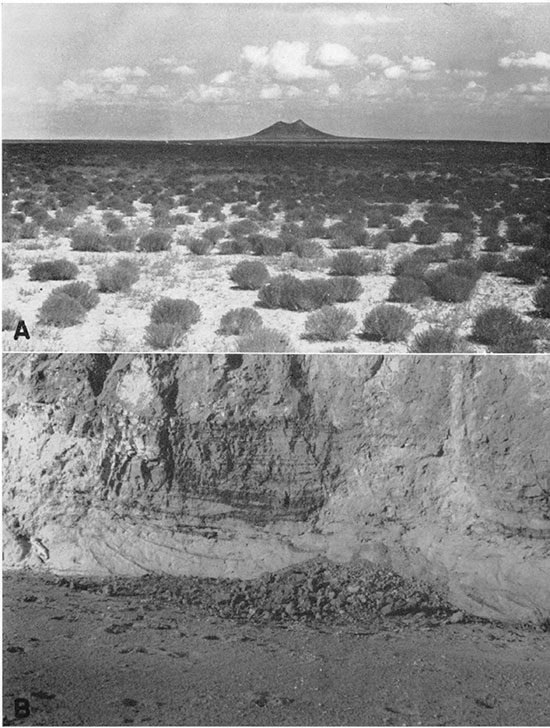
Concurrent with deposition there may have been some subsidence in the Stevens County basin, the Finney basin, and the Stanton County basin, leading to the local accumulation of sediments in abnormal thickness. A part of the subsidence certainly took place in post-Ogallala time, however, and the rest may have taken place in pre-Ogallala time.
The so-called mortar beds are of two types: normal sandstone and conglomerate, and irregular, structureless deposits of sandy, megascopic ally amorphous calcium carbonate, best described as caliche (pl. 11B). The former represent products of cementation by underground waters, similar to equivalent lithologic types found throughout the geologic column. The second type of "mortar bed," however, is best explained as a product of surficial calichification, formed during a relatively long pause in deposition, probably while the streams involved had shifted to some distant part of their respective zones of influence. During such periods of undisturbed exposure, there was ample opportunity for concentration of calcareous matter in the soil zone by surficial processes. A discussion of the nature of these processes is beyond the scope of the present report, but is found in papers by Price (1933), Theis (1936), Sayre (1937, pp. 67-70), and Schoff (1939, pp. 82-84). The process of calichification was periodically halted by the deposition of new layers of sediment, each time to be resumed at successively higher levels, thus leading to the incorporation of numerous buried caliche zones in the formation. The imprints of plant stems or roots found at some places may be explained as a result of differential deposition of calcium carbonate in sandy casts of plants buried by fluvial deposition, but subsequently left within reach of the zone of calichification.
Cause of deposition--The ultimate cause of the deposition of the Ogallala beds has been variously interpreted. Haworth (1897a, p. 14) correlated the deposition of the formation with uplift in the mountains, but went so far as to assume that the alternation of coarse and fine beds was due to the effect of intermittent uplift in causing repeated steepening of stream gradients. Johnson, on the other hand (1901, p. 628), believed that climatic changes alone were adequate to account both for the deposition and for the subsequent dissection of the formation. Darton (1920, p. 8) later emphasized the tectonic factor, but admitted climatic conditions as a contributing factor, stating that--
these alternations of later Tertiary deposition and erosion, first in the north and then in the south, were undoubtedly determined by differential uplift, the uplifted region undergoing erosion and the depressed or stationary region receiving deposits from streams whose slope was not sufficient to carry off their loads, This condition was accentuated by the semiarid climate of the plains, where then, as now, the mountain torrents and the resulting vigorous erosion furnished large quantities of debris, which the streams, being of low declivity and constantly diminishing volume as they crossed the plains, were unable to carry to the sea.
Fenneman (1931, p. 35) is noncommital as to the cause of deposition.
Much additional information has become available since these investigators presented their interpretations, and much still remains to be learned. Although it is premature to attempt any final explanation, it is well to integrate the known facts and to explore more fully the several possibilities, with a view to clearing the way for subsequent studies. Such is the endeavor of the following paragraphs.
The importance of (1) the climatic factor in causing deposition may be considered from the following angles: (a) nature of the climatic trends in late Tertiary time; (b) probable effect of climatic control on the locus of deposition; and (c) adequacy of climatic control to account for the deposition of earlier Tertiary formations in the plains region. Evidence as to the nature of climatic trends in late Tertiary time is found mainly in paleobotanical studies. Although fewer fossil floras have been found than is desirable, it is believed that these point toward increasing aridity in Miocene and Pliocene time (Chaney and Elias, 1936, pp. 25-32). The effect of such progressive desiccation on streams would have been increased loss of volume, and consequent deposition, owing to evaporation and to diminution of local inflow from both surface and subsurface drainage. Such effects should have been greatest in the belt of minimum precipitation. At present, that belt lies well to the west of the Kansas-Colorado line, but available figures indicate that the zone of maximum thickness in the Ogallala lies well to the east of the state line. Unless there has been a pronounced shift in rainfall zones since the deposition of the Ogallala, which there is no reason to assume, these considerations cast grave doubts on the adequacy of climate to have been the dominant factor controlling deposition. Furthermore, the climatic factor can hardly be invoked to account for the deposition of the much greater thicknesses of Oligocene and Miocene beds elsewhere in the plains region, and insofar as these beds were laid down under the control of factors other than climatic changes, it is logical likewise to assume similar control for the deposition of the Ogallala itself. Admitting climatic change as an important contributing factor, it is still necessary to look elsewhere for the prime cause of deposition.
Turning now to the role of (2) tectonic factors, the several possible loci of crustal movement may be considered: (a) uplift in the mountain area, (b) downwarping in the plains area, (c) upwarping in the plains area, and (d) combinations of these.
(a) If uplift took place in the mountain area, the effects should have been a steepening of stream gradients, quickening of erosion, increased stream load, and possibly increased rainfall within the mountains. Unless the balance of these effects was such as to leave the streams underloaded on emerging from the area affected by the uplift, which seems very improbable, it is expected that the deposition resulting from these factors would take place immediately beyond the hinge line of the uplift, where stream gradients remained unchanged, and that there the deposits would ultimately attain maximum thickness. If one assumes that the hinge line of the uplift was far to the east of the present mountain front--near the Kansas border--it is entirely feasible to account for the deposition of the Ogallala on this basis. If analogies may be drawn from post-Ogallala uplift, as interpreted by me, this assumption seems entirely plausible, but unless it be granted that the uplift did affect a wide belt of the plains area as well as the mountain area, the explanation for deposition must be sought elsewhere. Additional considerations bearing on this point are discussed in a later paragraph dealing with correlation of events between the plains and the mountains.
(b) It seems to have been generally though tacitly assumed by most writers that the plains area was an essentially passive tectonic element in late Cenozoic time, and that the mountain area was the principal locus of such active crustal movements as occurred. Inasmuch as there is cause for doubting post-Ogallala stability, as pointed out in a later section, it seems unnecessary to assume preOgallala stability, and it becomes pertinent to consider the possible consequences of pre-Ogallala warping entirely within the plains area. If the warping was mainly in the direction of subsidence, deposition would undoubtedly have taken place in the areas affected, would have been limited to those areas, and would have led to maximum thickness of sediment where the amount of subsidence was greatest. It is possible that the unusual thickness of Tertiary deposits in Steven's and Seward counties, and at other points in southwestern Kansas, may have been so caused. Regional downwarping would have been necessary, however, to account for the regional extent of deposition.
(c) Upwarping in the plains, on the other hand, would have been of more far-reaching effect. Stream gradients would have been flattened, or actually reversed locally, and drainage lines might have been broken or shifted, and stream patterns modified. Deposition would have begun at points of change in gradient, and would gradually have extended both upstream and downstream, affecting an area considerably wider than that in which the warping actually took place. A chain of individual upwarps, if not too far separated, could have had a profound effect on areas upstream, and might have been adequate to have effected the deposition of a continuous alluvial mantle. Detailed physiographic studies that might aid in evaluating or elaborating these possibilities are yet to be made.
(d) There remains the possibility of two or more of the above factors in combination, and in summary it may be stated that the deposition of the Ogallala may be adequately explained either on the basis of broad uplift of the mountains together with a wide adjoining section of the plains, or of upwarping in the plains area, or by some combination of these, not necessarily synchronous. Local subsidence may have been an important contributing factor, and the existence of relatively arid climatic conditions, plus any increase in the degree of aridity during Pliocene time, must also have played a significant part. In the light of available information, no definite evaluation of the relative importance of the different possible tectonic factors can be made. It is hoped that future studies, both in the outcrop area of the Ogallala, and in bordering areas to the east and to the west, may contribute to a more definitive interpretation. The hypothesis of epeirogenic upwarping in the plains area as a causal factor is especially commended to the attention of other investigators of late Tertiary history.
Origin of the capping limestone--The origin of the limestone at the top of the Ogallala is a problem in itself. Two hypotheses have been advanced: (1) Lacustrine deposition, and (2) subaerial origin as a caliche zone.
(1) Lacustrine origin of the capping limestone of the Ogallala has been ably advocated by Elias (1931, p. 141), whose arguments may be summarized as follows: (a) The uniform thickness and persistent lithologic characteristics of the limestone are believed incompatible with fluviatile origin. (b) The concentrically banded structures are thought to be best explained as deposits formed by algae of the genus Chlorellopsis, whose modern relatives precipitate calcium carbonate along lake shores, but not in running water. (c) The structure and texture of the limestone are regarded as dissimilar to those of caliche or of related calcareous deposits formed in the soil zone. Elias pictures the rock as having been deposited "on the nearly flat bottom of a very large and very shallow lake at the close of Ogallala time." Such a lake must have been of enormous size, extending from Nebraska to the Oklahoma panhandle or farther, and from Barton county, Kansas, west into Colorado. The considerable difficulties attending this hypothesis are mainly those of satisfactorily explaining the origin of such ponding. If it be granted that upwarping in the plains area was a factor in leading to the deposition of the Ogallala, it follows that a renewal of such movement might result in ponding of streams from the mountains. Even assuming these conditions, however, there is a strong probability that a balance between inflow and evaporation would have been reached long before the lake or lakes in question attained required size. Furthermore, the amount of uplift necessary to produce a horizontal water surface of the extent postulated would have been much greater than that required merely to flatten stream gradients sufficiently to induce deposition. It must have amounted to hundreds of feet, and therefore would be expected to have left some tangible evidences of its existence. The required shallowness of the postulated ponding presents added difficulties, which demand so delicate a graduation in the amount of uplift from east to west over so large an area as to be challenged by probabilities. Finally, it may be noted that the trend of the postulated uplift would be required to have been nearly transverse to that of the uplift which must have followed shortly thereafter, and which was responsible for the present drainage pattern. Theis (1936) avoids the difficulties of accounting for a single great shallow lake by suggesting that the capping limestone was deposited, either by inorganic or by organic agencies, in unconnected pools. The pools are believed to represent the flooding of shallow depressions by a rising water table under conditions of a cooling climate and probably increasing precipitation associated with the approach of Pleistocene time, but the origin of the depressions is not discussed. It remains to be ascertained how well this concept fits with the distribution of the algae discussed by Elias.
(2) The caliche hypothesis was originally advanced for the Oklahoma area by Gould and Lonsdale (1926, pp. 29-33), and later was provisionally accepted by Schoff (1939, pp. 79-85). Factors favoring the caliche hypothesis are as follows: (a) The limestone grades downward into more or less typical caliche. (b) The limestone is arenaceous. (c) Where the capping limestone rests directly on Permian redbeds, south of Englewood, it grades downward into a pseudo-breccia of redbed chips and blocks surrounded by an irregular boxwork of calcareous cement, suggesting the action of subaerial weathering processes, and hardly compatible with subaqueous processes. (d) At the same locality, scattered pebbles of exotic rock are scattered sparsely through the limestone--a relation difficult to reconcile with the postulated lacustrine environment.
Additional facts from a wide area are necessary for a final solution of the problem. Possibly both hypotheses are partly right, and both caliche and lacustrine limestone are present in different parts of the region, possibly gradational into one another. Insofar as the limestone is a caliche, it corresponds to the old-age type of Price (1933), and represents the effects of more or less recrystallization of the original calcareous deposit, and insofar as it represents a caliche, either wholly or in part, its deposition antedates the Kingsdown formation, and is not to be confused with the products of present-day soil processes. The final solution of the problems of origin will depend principally on the answers to the following questions: Is it possible that the concentric structures, in part, can be attributed to inorganic processes? Granting that some true algae are present, is their distribution uniform or spotty? Can the presence of lime-secreting algae be explained on the basis of environments provided either by sluggish streams or by small, unconnected lakes, as well as by that of a single large lake? Does the capping limestone show any systematic lateral variations in thickness or texture or structure? Is the lateral and vertical distribution of insoluble materials more suggestive of calichification or of lacustrine deposition?
Correlation with events in the Rocky Mountain area--In closing the discussion of the Ogallala formation, there remains the correlation of depositional history in the plains area with the erosional history of the mountains to the west. The latter being a controversial topic, the history of the Ogallala may be considered in relation to each of the two principal competing hypotheses, in turn.
The older interpretation of Front Range physiography may be termed the "two-surface" hypothesis. It was formulated by Lee (1922a), extended by Mather (1925) and by Little (1925), adopted by Fenneman (1931), and reaffirmed by Atwood (1938). It recognizes the existence of two major erosion surfaces, or peneplains. The older and higher of these surfaces, unrelated to the Ogallala, was named the Flattop peneplain by Lee, and is believed to have been formed before the close of the Eocene. The younger and lower of the major erosion surfaces was referred to as the Rocky Mountain peneplain by Lee, Mather, Little, and Atwood, and as the South Park peneplain by Fenneman (1931, p. 98). It is the formation of this erosion surface that is correlated with the deposition of the Ogallala. As summarized by Fenneman (1931, p. 107)--
It may be assumed that at the close of the later cycle the greater part of this province and others adjacent were covered by a continuous graded plain, made by degradation of the mountains and aggradation of the Great Plains. The peneplain in the mountain province is believed to correspond in geologic date with the surface of the Pliocene sediments that now cover the High Plains.
Fenneman (1931, p. 35) believes the Ogallala to be the principal depositional correlative of the peneplain, but Atwood (1938, p. 967) includes also the Arikaree, which is of Miocene age (Lugn, 1939), and possibly earlier Tertiary formations (1938, p. 964). Choice between these viewpoints depends on assumptions as to the cause of deposition. If it be assumed that tectonic movements in the mountain area were the prime factors, then it follows that the same uplift must have initiated both the cutting of the Eocene peneplain in the mountains and the deposition of Pliocene sediments in the plains-a somewhat anomalous circumstance. If, on the other hand, it be assumed that crustal warping in the plains was the main factor, then it follows that such movements may have effected simply one or more shifts in the locus of deposition (and erosion) within the plains during one continuous cycle of erosion in the mountains, thus allowing a much longer interval for peneplanation, and fitting better with the two-surface hypothesis.
In any event, according to the two-surface hypothesis, after the deposition of the Ogallala--
The country then rose to about its present height, not this time as a mountain range but as a gentle arch sloping 100 or 200 feet per mile from the axis to an indefinite base far out on the plains. There was 'then no mountain "front", no foothills, no mountains in fact, except the residuals of older cycles rising above the upraised peneplain. (Fenneman, 1931, p. 108).
The present abrupt mountain front is attributed to differential erosion in the ensuing "canyon cycle."
The second and more recent of the hypotheses as to Rocky Mountain physiography may be termed the multi-surface hypothesis, and was advanced by Van Tuyl and Lovering (1935). These workers recognize five major erosion surfaces ranging in age from early Eocene to middle Miocene, three subordinate surfaces dating from the late Miocene to the late Pliocene, and three to five Pleistocene terraces. The Mt. Morrison berm, dated as middle Pliocene, is correlated with the surface under the Nussbaum formation, which is regarded as equivalent to the Ogallala. The Mt. Morrison berm represents a mature valley stage restricted to the larger streams near the mountain front, and cut several hundred feet below the Flagstaff Hill berm, next older. It is not specifically stated which erosion surface corresponds to the top of the Nussbaum formation, or which erosion cycle is to be correlated with the deposition of the Ogallala formation, but choice is restricted to either the Mt. Morrison cycle or the Orodell cycle, next ensuing, and in either case the deposition of the Ogallala must be correlated with the cutting of a minor erosion surface of small extent. Analysis of the volumetric relations of Ogallala erosion and deposition at once presents insurmountable difficulties to this interpretation. The present area of the Ogallala surface in Kansas and in eastern Colorado between the same parallels (37° to 40°), restored by interpolation across dissecting valleys, is roughly 1,225 townships. Originally it was probably much greater. The source area of the formation, from the mountain front up to the Rio Grande Divide and the Continental Divide, comprises roughly 300 townships, and originally may have been somewhat larger. These figures indicate that the ratio of erosion per unit area in the mountains to deposition per unit area in the plains Was roughly 4 to 1. Assuming that the average thickness of the Ogallala is 100 feet, which seems a conservative estimate, and allowing 20 percent for porosity, it seems that the deposition of the Ogallala beds represented an amount of erosion in the mountains equivalent to a uniform lowering of the surface in the entire area by more than 300 feet. Obviously erosion did not progress in any such areally uniform fashion, but was concentrated along the larger valleys, thus necessitating a proportionately increased volume of erosion in the valley areas to supply material for the Ogallala-an amount of increase depending on the spacing of the streams and on the shape of their valleys at different distances from the mountain front. Although it is difficult to evaluate these factors exactly, the conclusion seems ines-capable that the volume of erosion required is altogether incompatible with the small extent of the erosion surfaces, and must have required a major erosion cycle of regional extent. Either the dating by Van Tuyl and Lovering is in error, or the multi-surface hypothesis is unsound elsewhere.
In any event, Ogallala time was probably brought to a close by stream rejuvenation incident to renewed upwarping. This uplift is believed to have affected both the mountains and the plains, in the latter taking the form of a broad, fan-shaped arch the apex of which lay between the present sites of Colorado Springs and Castle Rock. On the upwarped depositional surface consequent streams took their courses in the semi-radial pattern so prominent in the present drainage.
Rexroad Formation
General Character and Distribution
The Rexroad formation is named from exposures along tributaries of Crooked creek on the Rexroad ranch, in sec. 22, T. 33 S., R. 29 W., Meade County, Kansas. The formation is especially distinguished and characterized by an assemblage of vertebrate fossils of late Pliocene age, described by Hibbard (1938a, 1939) from localities in Meade County as the Rexroad fauna. Its known outcrop areas are confined to Meade County and to the headwaters of Bluff creek in northern Clark County. It has previously been mapped as Ogallala. The present description is preliminary only, more comprehensive studies by Hibbard and John C. Frye being in progress.
In Meade County, the Rexroad formation is best exposed southwest of Meade, along tributary streams entering Crooked creek from the west. At localities where diagnostic fossils have been found, it consists of alternating beds of gray to reddish mudstone, buff sandy silt, rusty sand and gravel, and a few thin seams of lignite (pl. 13B). The gravel is locally cemented to form a conglomerate very similar to that found in the Ogallala, but contains some calcareous pebbles seemingly reworked from the Ogallala. Calcareous concretions, some small and knobby, some large and boulder-like, are common in the finer-grained beds. Some beds in the Rexroad are indistinguishable from typical Ogallala, and others are very similar to those found in Pleistocene deposits exposed elsewhere in Meade County, but stratigraphic relations and other features of these beds are believed to be more or less distinctive. The fossils found in the Rexroad include both vertebrates and invertebrates (Baker, 1938), the latter being absent from the Ogallala of this area, so far as known. Grass-seed floras, common in the Ogallala, have not been found in the Rexroad.
The probable minimum areal extent of the Rexroad, both surface and subsurface, is shown in figure 10. This map is based on interpolation between known fossil localities, and on extrapolation beyond these localities on the basis of lithologic similarity and inferred continuity of the topographic conditions that governed deposition. It may be noted that no recognizable outcrops of the Rexroad were found on the east side of Crooked creek south of Meade. If present there, it is thin, and is lithologically indistinguishable from the Ogallala (see section, p. 66).
Figure 10--Sketch map showing the outcrop belt of the Rexroad formation and the inferred minimum extent of the formation under cover.
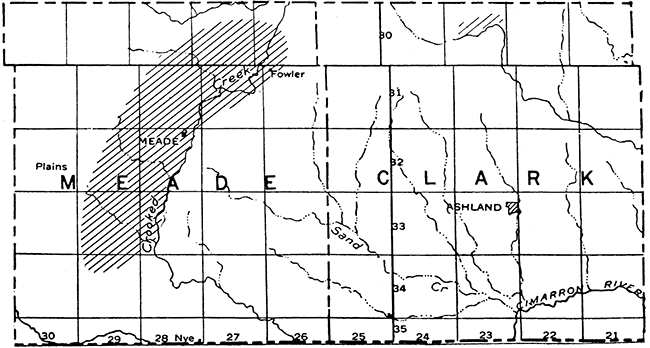
The base of the Rexroad is nowhere known to be exposed in Meade County, and the complete thickness is consequently problematical. Individual exposures do not exceed 35 feet in thickness, and correlation between them is inexact. It is probable, however, that the thickness is at least as great as the local relief of the topography, which is about 80 feet, and, according to John C. Frye, recent test drilling indicates that the thickness may exceed 250 feet.
The relations of the Rexroad to the Ogallala must be interpreted from indirect evidence, for no exposure of the contact between the two has been found. Significant are the following facts: (1) on the west side of Crooked creek valley, the Rexroad crops out at lower elevations than the Ogallala on the east side of the valley; (2) Crooked creek valley is known from other evidence to represent a structural trough; (3) no Rexroad deposits have been found east of Crooked creek valley; and (4) the Rexroad seems to contain more or less reworked Ogallala material. These facts strongly suggest that the Rexroad formation was laid down on the deformed surface of the Ogallala, in a structural and topographic depression that was progressively modified by marginal erosion concurrent with deposition. The Rexroad is thus believed to have been originally unconformable on the Ogallala, and later to have been involved also in renewed downward movement, as outlined more fully in the section on structural geology.
In northern Clark County, beds corresponding to the Rexroad occur along the upper stretches of Bluff creek and its tributaries. These deposits consist mainly of sand and gravel, somewhat iron-stained, and moderately well cemented toward the top. Their recognition is based on Hibbard's identification of fragmentary vertebrate fossils. The thickness where the beds are best exposed is about 25 feet. These beds seem to be underlain directly by the Cretaceous in places, and are overlain by the Kingsdown formation of Quaternary age. It is uncertain whether the underlying Cretaceous was originally buried by the Ogallala and later uncovered by stream channeling, or whether it was never entirely covered. Although the outcrops of the Rexroad are confined to a relatively small area, they undoubtedly represent portions of a continuous and more widespread deposit. The true extent of this deposit, whether great or small, however, is thoroughly concealed by the Kingsdown formation and by loess, and can be determined only by test drilling, if at all.
Age and Correlation
The vertebrate fauna thus far described from the Rexroad formation includes the following (Hibbard, 1938a, 1939):
| Vertebrate fauna of the Rexroad formation | |
|---|---|
| Sorex taylori Hibbard Mustelid sp. Canidae sp. Machairodus sp. Felis sp. Citellus sp. Eutamias or Tamias sp. Geomys sp. Eocastoroides lanei Hibbard Peromyscus eliasi Hibbard Sigmodon intermedius Hibbard Pliolemmus antiquus Hibbard |
Phenacomys primaevus Hibbard Pliopotamys meadensis Hibbard Neondatra kansasensis Hibbard Nannippus phlegon (Hay) Equus (Plesippus) cf. E. simplicidens Cope Platygonus sp. Camelops sp. Pratilepus kansasensis Hibbard Dicea lepuscula Hibbard Hypolagus regalis Hibbard Nekrolagus progressus (Hibbard) |
Large additional collections are now being studied by Hibbard, and the complete fauna is believed by him to point unmistakably to late Pliocene age. It may be noted in addition that the Hipparion cragini, reported from the headwaters of Bluff creek by Hay (1917), is thought by Hibbard to be more probably Nannipus phlegon, which is of late Pliocene age, and the Equus leidyi, described by the same writer from the same place, is regarded as possibly being Equus cumminsi, also of late Pliocene age.
The following invertebrate fauna has been described from the Rexroad formation by Baker (1938):
| Invertebrate fauna of the Rexroad formation |
|---|
| Vertigo hibbardi Baker Strobilope sparsicostata Baker Carychium perexiguum Baker Menetus kansasensis Baker |
These forms all represent new species, and having been correlated with vertebrate faunas of known age may be helpful in distinguishing exposures of Rexroad beds that contain invertebrates but are barren of vertebrates.
No correlatives of the Rexroad are known elsewhere in Kansas nearer than the McPherson area, where the upper part of the Emma Creek formation has yielded a few upper Pliocene fossils (Lohman and Frye, 1940). The Blanco beds in Texas are believed to be the next nearest equivalent. This absence of corresponding deposits within a wide radius, together with a definite age difference, divergent lithology, and apparently unconformable relations to the Ogallala, indicates that the Rexroad may not properly be regarded as a part of the Ogallala, and is best designated as a separate formation.
Origin of the Formation
The climate of Rexroad time is interpreted by Hibbard (1938a) to have been cooler and more humid than that of the same area today. It is believed also to have been cooler than that of Ogallala time, thus foreshadowing Pleistocene glaciation.
The localization of the Rexroad formation in Meade County is best explained as having been caused by the formation of an elongate structural and topographic depression trending roughly northnortheast. The origin of this trough is discussed in the section on structural geology. The effect of such a trough would have been to trap the water and sediment of any through-flowing streams traversing the area, and to rejuvenate erosion in the steepened flanking slopes. Dissection of the Ogallala beds in these bordering areas, but mainly on the western side, would have occurred, and the reworked materials would have been deposited as an alluvial fill in the axial portion of the trough, gradually overlapping farther and farther onto the side slopes as filling progressed. Probably some ponding occurred also, which would account for the deposition of the day beds. On this interpretation, it is possible to explain the Rexroad formation of Meade County as a purely local depositional unit, composed entirely of reworked Ogallala material. There is at present no reason for either affirming or denying the likelihood of through-going drainage connections with the Rocky Mountain area. If such connections existed, additional material would have been supplied directly from primary source areas.
In post-Rexroad time there was renewed downward movement of the depositional trough, intervening deposition of a considerable thickness of Pleistocene beds, and ensuing stream dissection.
The Rexroad beds of Clark County are too imperfectly known to be explained adequately. Undoubtedly they were deposited in a drainage system different from that of today, before the present course of Bluff creek was established through piracy, and possibly before any part of Bluff creek had come into existence. Whether they were deposited by local streams or by through-going streams from the mountains, and whether they have any subsurface continuity with the Rexroad beds of Meade County, is unknown. Possibly one or both deposits is related to the abnormal breadth of the outer valley of Arkansas river in southeastern Kearny County, southern Finney County, and central Gray County, as shown on the contour map (pl. 2) and by the width of the sand-hill belt (fig. 15). If this anomalous topographic feature represents a shallow post-Ogallala downwarp, as seems probable, it undoubtedly had an important influence on the ancestral Arkansas and other streams.
Prev Page--Stratigraphy--pre-Tertiary || Next Page--Stratigraphy--Quaternary
Kansas Geological Survey, Geology
Placed on web Feb. 8, 2017; originally published September 15, 1940.
Comments to webadmin@kgs.ku.edu
The URL for this page is http://www.kgs.ku.edu/Publications/Bulletins/34/05_strat2.html