Kansas Geological Survey Bulletin 137 is entitled "Symposium on Geophysics in Kansas," although there was never really a symposium associated with it William W. Hambleton simply twisted the arms of people he knew who were doing geophysics in Kansas and then edited the resulting papers into a volume that is useful today. Bulletin 137, however, has been out of print for several years. After some discussion we decided that our efforts would be better spent in providing a new and updated version, rather than reprinting the old volume. The result was a "Symposium on Geophysics in Kansas-a 25-year update," which was held in Wichita in November of 1984 and attended by more than 240 people. This volume, Kansas Geological Survey Bulletin 226, is the proceedings volume from that conference.
Much has happened in Kansas in the past 25 years in the area of geophysical knowledge, and much has happened in geophysical techniques, instrumentation, and theory. Consider that the CDP seismic method was developed since then, made practical by digital computers which were also in their infancy in 1959. While much has happened in the way of progress, much of the old seismic data from the 1940' s and 1950' s are still useful for today's explorationist, The paper on the utility of correlation-point seismic reflection clearly relies on tried and true techniques from that era.
Several papers in this volume make use of the CDP seismic method. While the method has had some spectacular successes in Kansas, there also have been failures. Most of the failures stem from lack of good velocity knowledge or from inadequate static corrections. Since many of the structures in Kansas that hold oil have only a few milliseconds of closure, small errors in either velocity or static corrections can cause structural lows to look like highs or vice versa.
Much of our research in seismic reflection at the KGS is directed toward improving resolution of the method. While most of the data shown in papers in this volume are at frequencies of less than 100Hz, we have made progress in the late 1980's that allows use of seismic energy of about 200 Hz to depths of as much as 1,000 feet in parts of eastern Kansas. We also are working to make the techniques more efficient and cost-effective. As recently as 1980, a cost of more than a half million dollars would be incurred in setting up to do CDP processing on seismic data. By late 1987, Brett Bennett, Dao Somanas, and Young Chung had produced a CDP processing package at the KGS that will allow an independent operator to begin processing data at a total cost for hardware and software of less than $10,000.
While much of our seismic-reflection work at the KGS is for small high-resolution projects, we have also been involved in the COCORP seismic-reflection project One paper in this volume is written by our COCORP co-investigators from Cornell University. The other was done by our own staff at the KGS. Much could be gained scientifically by additional reprocessing and analyses of the COCORP data. It is also noteworthy that the COCORP lines 1 and 4 fortuitously crossed the Poersch dome in Washington and Marshall counties. The Poersch dome is more than 10 miles across with about 5,000 feet of closure. The COCORP data were of use to Texaco in defining the dome and in their decision to drill the #1 Poersch well into the top of the dome to a total depth of 11,300 feet, setting a drilling-depth record for Kansas.
Primarily through the efforts of Dr. Harold Yarger, the combined gravity- and magnetic-data coverage in Kansas is unexcelled by any other state in the union, both in terms of quantity and quality. There remains a great deal of additional processing and interpretation that can be done to enhance the use of these data. Increased use of ever cheaper microcomputers in the independent petroleum industry will make these data a more valuable asset in the future.
Dr. John Doveton of the KGS staff has published many of his unique and innovative approaches to automated well-log analysis in other places but was generous with his time in putting together a paper on borehole geophysics. Other efforts in the state in geophysics have included the work by Dr. Ken Kodama at Lehigh University in the area of paleomagnetism and in heat flow by Dr. David Blackwell of Southern Methodist University.
Those who attended the conference did not hear my own paper on "Structure of the Forest City-Salina Basin boundary from seismic studies." This paper was not presented at the symposium but was presented originally as a McNutt endowed lecture at the University of Missouri at Rolla in 1980. The paper was published in the UMR Journal, No. 3, and, by permission of the Department of Geology at UMR, is reproduced here.
Last but not least is a paper by William W. Hambleton that he prepared as food for thought for Kansas scientists and explorationists alike. This paper was sort of Bill's parting shot to Kansas' geophysics community prior to his retirement in 1987. To him and his foresight in developing a quantitative approach at the Kansas Geological Survey, we dedicate this volume.
Don W. Steeples
Kansas Geological Survey
Lawrence, Kansas
May 6, 1988
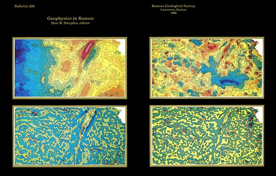
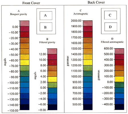
On the cover--The four maps featured on the front and back cover of this bulletin were created by the SURFACE III contouring and mapping program developed at the Kansas Geological Survey. The front cover maps are of gravity data collected by the Survey. Data spacing is one mile by two miles in western Kansas and varies from one mile by one mile to one mile by six miles in eastern Kansas. The maps on the back cover are from aeromagnetic data collected by the Survey. The original data set consists of two-mile-spaced east-west flight lines, flown at several altitudes. Point spacing along the flight lines is twelve to seventeen points per mile. These maps were created with a flight-line straightened version of the original aeromagnetic data. Both the gravity and magnetic data were gridded at one mile by one mile before contouring. In each case, the filtered maps were created by smoothing the original grid over ten-mile windows and then subtracting the smoothed data from the original data, bringing out higher frequency features. Other possible analyses include trend removal (first and higher orders), first and second derivative, and shaded- relief studies.
Kansas Geological Survey
Comments towebadmin@kgs.ku.edu
Web version July 20, 2013. Original publication date 1989.
URL=http://www.kgs.ku.edu/Publications/Bulletins/226/index.html