| Original published in D. W. Steeples, ed., 1989, Geophysics in Kansas: Kansas Geological Survey, Bulletin 226, pp. 229-243 | ||
Applied Geophysics, Inc.
The article is also available as an Acrobat PDF file.
On detailed total-intensity aeromagnetic maps of southeastern Kansas (Sumner, Sedgwick, Butler, Elk, and Greenwood counties), it is possible to recognize individual basement plutons within the area designated as "granitic to quartz-monzonitic intrusive rocks" by Bickford et al. (1979) and dated as 1.4 to 1.7 b.y. in age. Cross-cutting relationships of several plutons are apparent on the magnetic maps, thus establishing relative ages between them. The youngest and largest individual intrusion mapped, the northwesterly trending Wichita Pluton in southeastern Sedgwick County, measures 20 x 13 mi (32 x 21 km). On the south and west, it cuts an older complex of north-north east-trending basement blocks, possibly meta-sedimentary or meta-igneous units. On the northeast, it truncates the smaller (7 x 5 mi; 11 x 8 km) Rose Hill Pluton. Farther east in southwestern Greenwood County, another individual intrusion of nearly the same dimensions as the Wichita Pluton has been recognized. The plutons appear on the magnetic map as magnetic lows with ringing magnetic highs and are therefore similar to the series of intrusions in southeast Missouri of nearly the same age described by Gay (1976) and later studied in more detail by Kisvarsanyi (1981). The pluton cropping out at Graniteville, Missouri, is considered the type intrusive. In Missouri the intrusions are clean, quartz-feldspar granites with few mafics, the mafics apparently having been precipitated in the host rocks, thus forming the ringing magnetic highs. Probably the same relationships will hold true for the southeastern Kansas intrusions after more basement-rock intercepts have been studied. Age dating of these intercepts should also establish absolute ages for the different units which have been dated only in relative fashion by the aeromagnetic studies. On the residual magnetic maps which outline basement features of shorter wavelengths presumably located at the basement subcrop, a series of north-northeasterly trending horsts and grabens cutting the Wichita Pluton is indicated. The bounding faults may have formed during the midcontinent rifting event at 1,100 m.y. B.P. and been reactivated during the Nemaha event in Pennsylvanian time. A left-lateral movement of 3 mi (4.8 km) or more is well documented along one of these faults, which also shows down-to-the-west post-Kinderhook throw from well studies (Shawver, 1965).
In 1982, a detailed aeromagnetic survey of an area in south-central and southeastern Kansas was carried out for a group of five oil companies. Flight lines were flown east-west at a barometric elevation of 2,500 ft (750 m) above sea level and an average line spacing of 3,800 ft (1,140 m) in the Wichita area. On the total-intensity magnetic map, a large oval-shaped anomaly was located (fig. 1), which consists of a central magnetic low and a ringing high. This feature is quite similar to anomalies described earlier in southeast Missouri (Snyder and Wagner, 1961; Gay, 1976; Kisvarsanyi, 1980, 1981) that are caused by highly acidic quartz-feldspar intrusions of late Precambrian age in the basement rocks. The unique nature of this anomaly was not apparent on the earlier flown aeromagnetic map of Kansas (Yarger et al., 1981) because of the small scale of compilation employed (1:500,000) and the wide grid interval and filtering techniques used (see fig. 2). It merges into, and forms a salient of, a much larger area of low magnetic values discussed by Yarger (1982): "This negative trend consists of a nearly continuous band across the state defined by total intensity amplitude less than 1,200 gammas. The most prominent low is centered over Wichita, negative anomalies of lesser magnitude continue westward to the Kansas-Colorado border [and] eastward into Missouri." In the present study area, the trend of magnetic lows is well defined by Yarger et al.'s 1,000-gamma contour line (fig. 2).
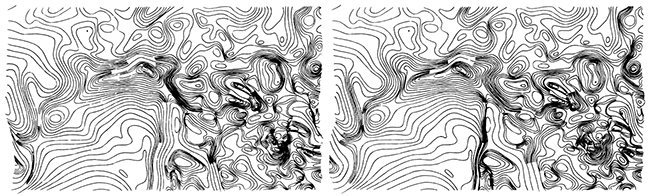
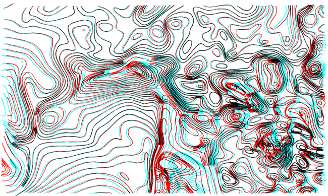
Because the possibility exists that the entire area of low magnetic values arises from a complex of similar large basement intrusions, Applied Geophysics, Inc., reached an agreement with the Kansas Geological Survey to recompile part of the 1981 aeromagnetic survey at a larger scale and submit it to other data-treatment methods. The resulting total-intensity magnetic map appears in fig. 3. A stereo pair constructed to aid in identification of the intrusions appears in fig. 4. The purpose of the present paper is to identify the various individual basement intrusions recognized on these two maps (figs. 3 and 4), to compare them to the ones in Missouri, and to discuss the regional geological setting of these mid-Proterozoic igneous intrusive masses. The much better known Missouri intrusions will be discussed first.Figure 1--Large oval-shaped total-intensity magnetic anomaly in the Wichita area appearing on a detailed 1982 petroleum-industry aeromagnetic survey.
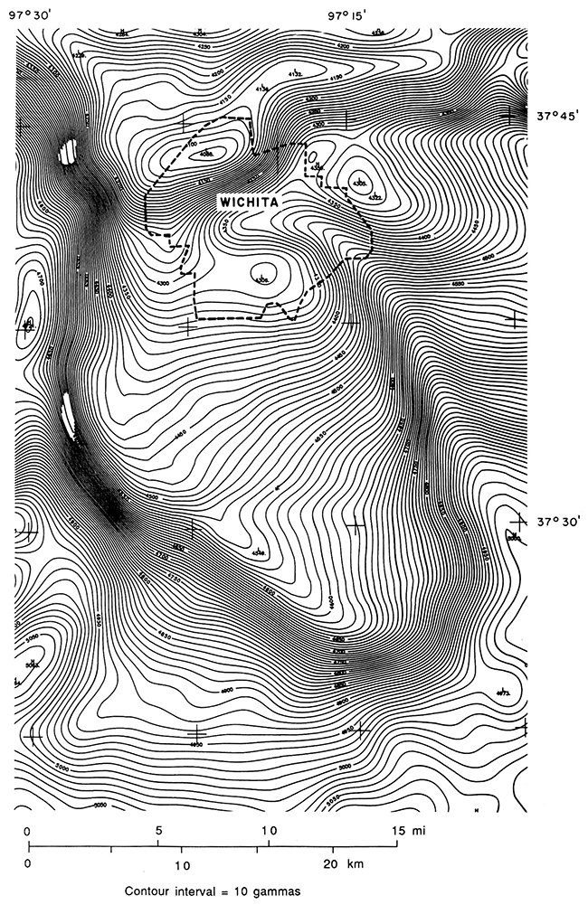
Figure 2--Total-intensity aeromagnetic contours redrawn from Yarger et al., 1981. The Wichita oval-shaped anomaly ("Wichita granite pluton") appears only as an embayment of a much larger area of low magnetic intensity (note 1,000-gamma contour line).
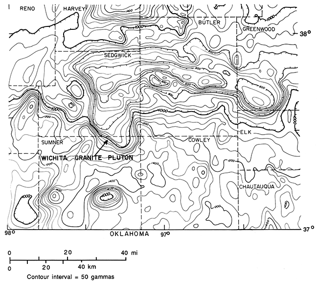
Figure 3--Recompiled Kansas Geological Survey aeromagnetic data of same area as Fig. 2. More detail is apparent because of the four-times larger compilation scale employed (1:125,000 vs 1:500,000), resulting in 16 times as much map area. This allowed a 10-gamma contour interval versus 50 gammas for the original map. (The reduced version in this figure has a 20-gamma interval.) Depth to basement beneath flight level varies from 4,500 ft (1,400 m) along the eastern side to 7,500 ft (2,300 m) in the southwest corner.
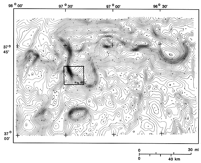
Figure 4--Stereo pair of aeromagnetic map of Fig. 3. Stereo view permits recognition of subtle, but important, features not visible on original "flat map," including the aeromagnetic lows with ringing magnetic highs discussed in this paper. (This stereo pair may be viewed with any ordinary pocket, or lens, stereoscope.)

In the 1950's and the 1960's, the Missouri Geological Survey, in cooperation with the U.S. Geological Survey, published a series of aeromagnetic maps covering the southeast Missouri mineral district. Snyder and Wagner (1961) were evidently the first to recognize typical granite intrusive anomalies of the type treated in this paper. They state "The shape and extent of the area of the Graniteville granite are indicated [on the aeromagnetic map], although actual outcrop of this granite is restricted. The magnetic pattern also suggests the possibility of a large granite area in the region east of Lesterville.... This area shows a broad low magnetic pattern, similar to, but not so intense as, the Graniteville low." Allingham (1964) incorrectly attributed the distinct magnetic lows to areas of deeper basement and termed the Graniteville anomaly a "basin," which it is in actuality, but the anomalous low arises principally from the lesser magnetite content in the underlying granite rather than the greater depth to source rock.
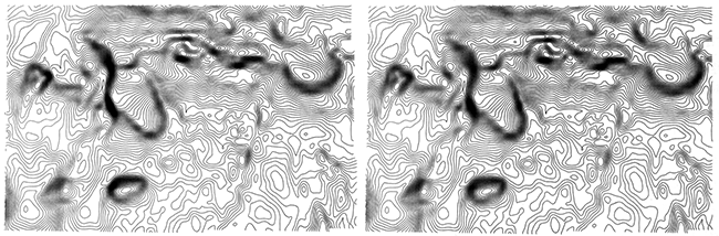
A composite stereo pair was prepared of a block of 17 of the Missouri aeromagnetic quadrangle maps (Scintrex, Ltd., unpublished maps, 1969), and on them a total of 11 basement intrusions of the type discussed by Snyder (including the two Snyder mentions) were recognized. A map of these was presented in 1974 at the First International Conference on the New Basement Tectonics (Gay, 1976). It is shown here in fig. 5. Figs. 6, 7, and 8 are aeromagnetic maps over portions of three of these intrusions, illustrating the quite distinct form of the anomalies, consisting of a featureless central magnetic low, and a typical ringing magnetic high (or highs) that occurs partially or fully surrounding the interior low, similar to the one around the Wichita anomaly. A stereo pair of the northern part of the Delaware Pluton (fig. 9) brings out the distinctive character of this high particularly well in spite of the superimposed complexity of localized highs and lows that confuse the nonstereo version.
Figure 5--Graniteville-type intrusions recognized from stereo pairs of aeromagnetic maps in southeast Missouri (redrawn from Gay, 1976). Black areas are Precambrian outcrops (from Tolman and Robertson, 1969). The word "plug" was originally used for these plutons following contemporary U.S. Geological Survey nomenclature of the time.
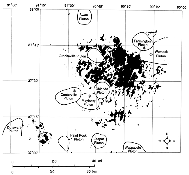
Figure 6--Succinct magnetic signature of the 8 x 5 mi (13 x 8 km) Paint Rock Pluton in southeastern Missouri. Data are from Missouri Geological Survey aeromagnetic map of the Cardareva quadrangle. Drill-hole intercepts show this to be a granite (B. C. Morrison, 1966 and 1974, personal communications). Note varying magnetic highs on north and west (also on east, not shown).
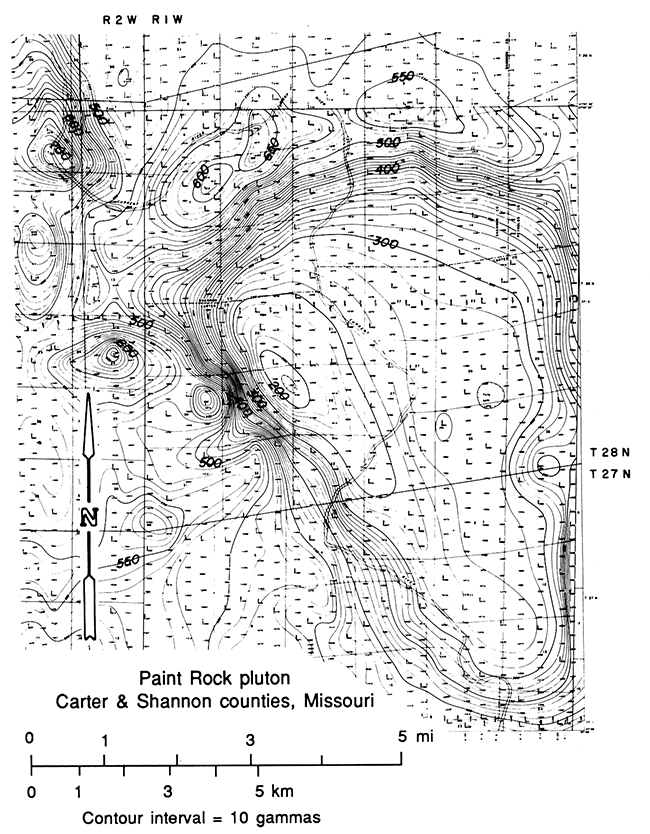
Figure 7--Magnetic map of the west half of the Graniteville Pluton in Iron County, Missouri. Data are from Missouri Geological Survey aeromagnetic map of the Edgehill quadrangle. Adjacent earlier survey to east is of lower quality and wider contour interval and is not shown. Ringing magnetic highs are high gradient, short wavelength, discontinuous, and evidently arise from magnetite contained in the host rocks.
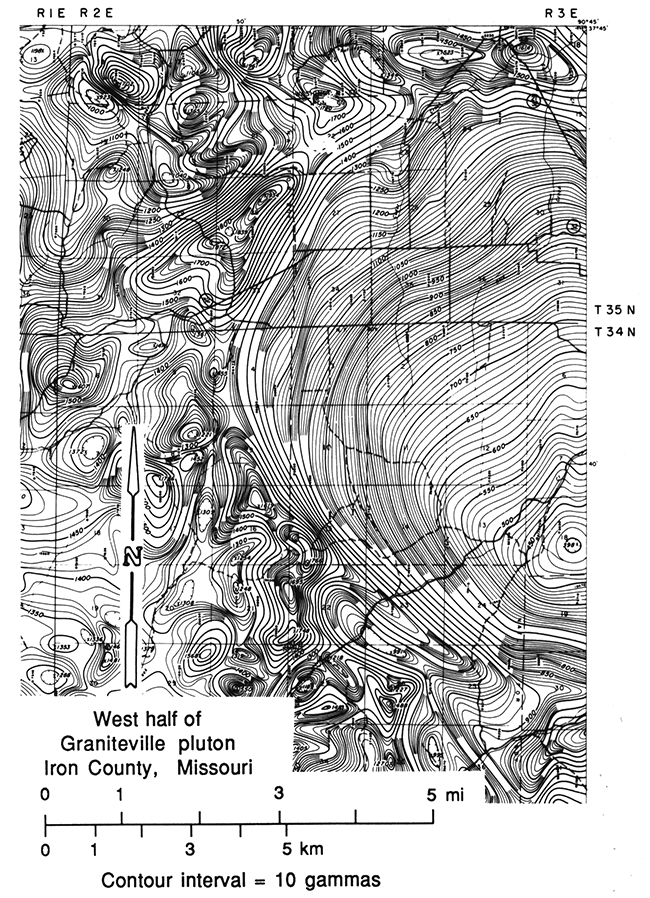
Figure 8--Magnetic map of north half of Delaware Pluton in Shannon County, Missouri, taken from unpublished Applied Geophysics, Inc., Brochure (1975). Black dots are basement drill-hole intercepts of rhyolite. Open circle is granite.
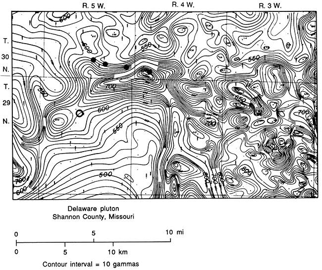
Figure 9--Stereo pair of same area shown in fig. 8. The stereo view shows the distinct, nearly uninterrupted nature of the magnetic high ringing the north half of the Delaware Pluton on west, north, and east. (View this with any ordinary pocket, or lens, stereoscope.)
During the 1960's, Asarco, Inc., drilled a number of exploratory drill holes for lead-zinc around the northern portion of the Delaware Pluton, and several of these holes penetrated basement (fig. 8). Four of the basement intercepts over the ringing high were identified as rhyolite, whereas the one to the south on the steep gradient encountered granite (D. Harper, 1984, personal communication). The boundary of the Delaware Pluton thus seems to follow the expected location along the gradient between magnetic high and low, and the intruded rocks here are older Precambrian rhyolites. Since rhyolites ordinarily do not cause strong magnetic highs, these rhyolites are assumed to contain an increased content of magnetite, resulting from proximity to the granite intrusion. Alteration and replacement aureoles are common features around igneous intrusions worldwide. They result from hydrothermal solutions which precipitate introduced magnetite (and other high-temperature minerals) and convert existing nonmagnetic iron-bearing minerals, such as iron silicates, iron hydroxides, hematite, etc., to magnetite. Criss and Champion (1984) present an extensive study of this phenomenon around the Idaho Batholith in the western United States, and Kisvarsanyi (1981) has recognized unusual "magnetite trachytes" adjacent to the boundary of the Swan intrusion in Missouri mapped by Gay (1976).
It has been suggested (K. Kodama, L. Serpa, 1984, personal communications) that the ringing magnetic highs are a natural consequence of the inclination of the earth's magnetic field or of a remanent component of magnetization. Such auxiliary highs can indeed contribute to the lithologically induced highs in the direction of the horizontal component of the earth's inducing field or of any remanent component of the field, but auxiliary anomalies solely due to inclined magnetization exhibit lesser amplitudes and lesser gradients than the primary anomaly. A good example may be seen in figs. 2 and 3 north of the Jackson Pluton in southeastern Sumner County. This north-side high disappeared when subjected to reduction to the pole technique, demonstrating its origin from magnetization of the plutons by the inclined earth's field. However, the ringing magnetic highs identified in this study as arising from magnetite in the host rocks exhibit high gradients (figs. 1, 6, 7, 8, and 9) and occur on several, or opposite, sides of the primary anomalies and thus cannot be explained by magnetization within the intrusion itself.
Lack of similarity of the ringing highs and the unpredictable pattern of them from one intrusion to the other, and even around the same intrusion, are attributed to the varying petrology and structure and permeability of the differing host rocks intruded, as these factors affect the percentages of magnetite being precipitated or formed, complicating the pattern of magnetite already present in the various host rocks. A study of drill-hole intercepts from existing cores and cuttings available at the Missouri Department of Natural Resources, Division of Geology and Land Survey, and at mine-company offices in Missouri could shed much light on this problem and would be a good geological graduate-thesis problem.
Another unique characteristic of the Missouri intrusions is their high erodibility which results in the occurrence of coincident paleotopographic lows. This may be observed in fig. 5 where the intrusions are seen to fall everywhere outside the outcrop areas even when they are completely surrounded by them, as is particularly the case with the Graniteville and Chloride plugs. Note how these two plutons are almost exactly outlined by Precambrian outcrops. The only outcrop area falling within any of the 11 intrusions identified occurs on the east side of the Graniteville plug, as mentioned earlier in the quote from Snyder and Wagner (1961). The petrology of these rocks is thus of particular interest for inferring the characteristics of the Kansas intrusions, but as yet no detailed petrographic studies are available in either area.
Kisvarsanyi (1981) examined cores from four of the 11 intrusions shown in fig. 5: Graniteville (4), Leeper (1), Wappapello (1), and Paint Rock (8) [number of drill holes available shown in parentheses] and concluded on the basis of chemical analyses that the intrusions are "two-mica" or "tin" granites. The analyses for individual samples from the four intrusive masses are given in table 1. [Note: The names used herein for these intrusions are those of Gay (1976) and not those of Kisvarsanyi (1980, 1981), who renamed six of the intrusions without giving a formal geological reason, in contravention of accepted scientific tradition and practice.] Kisvarsanyi presents no studies of individual minerals present in the granite samples, and the iron content is not divided into ferric or ferrous components from which we could estimate the percentage of magnetite present, so it is not possible to determine from the data on hand why the magnetic susceptibility of the intrusions is so low.
Table 1--Chemical analysis of core samples from Graniteville-type intrusions in southeast Missouri (from Kisvarsanyi, 1981).
| Intrusion | Na (wt%) |
K (wt%) |
Fe (wt%) |
Mg (wt%) |
Ca (wt%) |
Ti (wt%) |
|---|---|---|---|---|---|---|
| Graniteville | 2.7 | 3.3 | 0.7 | 0.05 | 0.1 | 0.1 |
| Paint Rock | 3.4 | 4.3 | 1.0 | 0.1 | 0.2 | 0.05 |
| Leeper | 2.7 | 3.1 | 1.5 | 0.15 | 0.2 | 0.15 |
| Wappapello | 2.7 | 4.0 | 1.0 | 0.02 | 0.15 | 0.05 |
Kisvarsanyi states (1980, p. 44) that the "two-mica" granites contain 5-10% biotite, but all rocks containing such large percentages of biotite are generally magnetic, as magnetite accompanies biotite, which is itself an iron-bearing mineral. Furthermore, the low percentages of iron and magnesium shown in table 1 would limit biotite to considerably less than 5-10%, even if the total amounts of these elements were taken up in biotite, a highly unlikely possibility. For example, the maximum amount of combined iron and magnesium appearing in table 1 is the sample from the Leeper intrusion: 1.5% Fe and 0.15% Mg. Biotite having the same ratio of these elements would contain approximately 31% Fe by weight, so the maximum possible amount of biotite would be 4.8% (1.5%/0.31). If we use the elemental average for all four samples in table 1, the maximum average amount of biotite obtained is 3.3%. However, it is unlikely that all of the total iron and magnesium present is solely taken up by biotite, so there is probably much less than 3.3% biotite in these intrusions. If they are "two-mica" granites, they must be a special kind, but it is more likely that they are simply a binary or "two-mineral" variety, consisting mainly of quartz and feldspar with few accessories as stated by the late Dr. Frank Snyder (1967, personal communication). This would better explain their low magnetic susceptibility. However, until the petrology of these intrusions is better known, I will simply refer to them as "Graniteville-type" granites.
The succinct, clear-cut boundaries of the Graniteville-type intrusions and the lack of fault offset shown on the aeromagnetic maps both indicate that little or no subsequent deformation (excluding epeirogeny?) has occurred to them or to the Missouri region since their formation. Bickford et al. (1981) and Bickford and Mose (1975) indicate that they intruded a terrane with age dates in the range 146G-1480 m.y. B.P. and are therefore somewhat younger. A finite time was required for their emplacement, and sequential development of several of the intrusions is indicated in fig. 5. The Mayberry plug is cut by the Centerville plug and thus is older than it, and the same relationship is shown by the Womack and Farmington plugs. The younger plutons in both instances lie west of older ones. Kisvarsanyi (1981) mistakenly shows the inverse relationship between the Mayberry and Centerville plugs, but the aeromagnetic data clearly show the Centerville plug to be younger.
The earlier terrane into which the Graniteville-type intrusions were emplaced consists of granites and rhyolites. Tolman and Robertson (1969) divided the granites into a number of different units, presumably individual plutons, such as the Butler Hill, Breadtree, Silvermine, and Slabtown granites. Kisvarsanyi (1980) further subdivided them into biotite and amphibole varieties. These earlier intrusions have no clear-cut magnetic characteristics like the Graniteville-types, because they exhibit diverse magnetic patterns of highs and lows, their boundaries are not clearly outlined by magnetics, and they are less susceptible to erosion, frequently forming outcrops. It is not known if formation of the younger Graniteville-type intrusions was a separate orogenic event from the one which formed the earlier granites or simply a continuing, but later, pulse of the same event. Bickford et al. (1981) infer that it was the latter.
In summary, the Graniteville-type intrusions:
Fig. 10 shows the boundaries of low-susceptibility intrusions in southeast Kansas interpreted from the aeromagnetic total-intensity contour map of fig. 3. Fig. 4 is a stereo pair of this same data which facilitated the interpretation. The most distinct individual intrusion is the Wichita Pluton, whose recognition in 1982 sparked the present study (fig. 1). The ringing magnetic high occurs nearly continuously around the west, east, and southeast sides. Elsewhere the intrusive boundary is defined by an area of steepened gradient. This intrusion is larger (20 x 13 mi; 32 x 21 km) than most of the Missouri ones, although four of the Missouri intrusions are only partially defined by the existing aeromagnetic data and could be of nearly equivalent size (fig. 5). The magnetic signature of the Wichita Pluton is more diffuse than those of the Missouri intrusions (compare fig. 1 with figs. 6, 7, and 8) due to the greater depth to basement beneath aeromagnetic flight level: 5,500 ft (1,680 m) in the Wichita area versus 500-2,000 ft (150-600 m) in Missouri.
Figure 10--Boundaries of Graniteville-type plutons recognized on aeromagnetic maps of figs. 3 and 4, together with basement well tests (Cole and Ebanks, 1979) and age dates (Bickford et al., 1981).
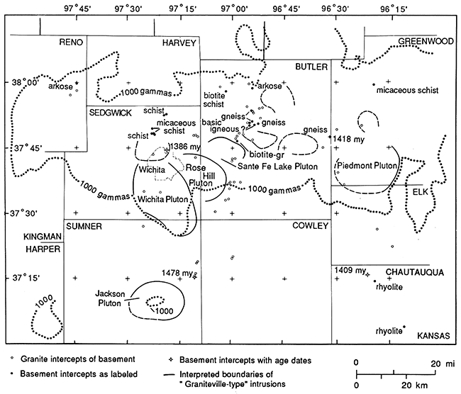
Note that the Wichita Pluton cuts the smaller Rose Hill Pluton (7 x 5 mi; 11 x 8 km) lying to the northeast and is thus younger than it. The Rose Hill Pluton, in turn, cuts the yet smaller and older Santa Fe Lake Pluton. The intrusions thus become younger westward, as do the Missouri ones.
Two other large intrusions are given positive identification: the Piedmont Pluton in southwestern Greenwood County-northwestern Elk County and the Jackson Pluton lying outside the main intrusive complex in southeastern Sumner County. Both of these have only partially developed ringing magnetic highs. Four possible smaller intrusions are shown lying between and north of the Santa Fe Lake and Piedmont plutons, and another exists north of the Wichita Pluton. There are many other magnetic lows in this area that are candidate intrusions, but none have sufficiently diagnostic anomalies with ringing highs to be given positive identification.
Fig. 10 shows the basement tests (circles) from Cole and Ebanks (1979), which provide a preliminary identification of the rock type penetrated. Open circles are granites, and all tests within the boundaries of the interpreted intrusions, 13 of them, are so identified. One of these lies within the boundaries of the possible pluton north of Wichita and has been dated by Bickford et al. (1981) at 1,386 m.y. B.P. Three other dates within the area of fig. 10, but lying outside the interpreted boundaries of the Graniteville-type intrusions, are slightly older: 1,409, 1,418, and 1,478 m.y. B.P. (Bickford et al., 1981). No petrologic descriptions or chemical analyses are available for any of these granite samples (Bickford, 1984, personal communication), so we do not know if the petrology of the interpreted Graniteville-type intrusions is similar to those in Missouri or not. However, the distinct magnetic signature and the similarity in ages would indicate that these rocks are indeed similar.
Fig. 10 shows the 1,000-gamma contour line from Yarger's 1981 aeromagnetic map (dotted line), which is interpreted as roughly defining the boundary of the intrusive complex in southeast Kansas. It is not known if the entire area is composed of overlapping plutons of the Wichita-Graniteville type, or if these younger plutons only occur scattered individually throughout an area of earlier granites and other rocks as in southeast Missouri. The most common rock type identified outside the boundaries of the intrusions is granite (open circles in fig. 10). Two rhyolite identifications outside the main intrusive complex were made in Chautauqua County, and a series of schists, gneisses, and basic igneous rocks are shown for northern Sedgwick, Butler, and Greenwood counties. The host terrane for the Kansas intrusions is thus different from that in Missouri, which is exclusively an acid igneous extrusive-intrusive complex with no metasedimentary rocks present. This may indicate that the plutonic event which formed the Graniteville-type intrusions in both areas is not closely related to the earlier acid igneous extrusive-intrusive event in Missouri but was separate from it.
The Graniteville-type intrusions in Kansas apparently occur on, or near a boundary between older Precambrian rocks on the north and younger rocks on the south, as suggested by Yarger (1982). His interpretation appears in fig. 11. Other evidence also tends to support this point of view. For example, fig. 12 shows a regional basement topographic map modified from Bayley and Muehlberger (1968). The southeast Missouri igneous complex is well defined by the Precambrian topographic high that culminates in the outcrops of the St. Francois Mountains (dark areas). The outcropping area is seen to be but one part of the overall Ozark uplift, which covers most of Missouri and extends westward into eastern Kansas and southwestward into the "ancestral Tulsa mountains" of northeastern Oklahoma. The long axis of the Ozark uplift extends east-west or west-northwest and is nearly co-linear with the southeast Kansas igneous complex as defined by the Yarger et al. (1981) 1,000-gamma magnetic-contour line. Yarger's (1982) boundary between the 1,625 m.y. and the 1,400 m.y.-old granites (fig. 11) also lies along this same axis. Further, many of the 1,380-1,450-m.y. granitic plutons described by Van Schmus and Bickford (1981, p. 278 and fig. 11-5) fall along a rough west-northwest trend. These and other intrusions of this same approximate age, such as those in northeastern Kansas, form magnetic highs, however, and are thus petrologically different from the Graniteville types. Perhaps all these different types of intrusions of the same age but of different lithologies could be accommodated by a plate-tectonic model that brought younger crust on the south against older crust on the north.
Figure 11--Precambrian terranes in Kansas (Yarger, 1982) inferred from magnetic maps and age data of Bickford et al. (1981). The Graniteville-type intrusions identified in this paper lie on, or along, the interpreted boundary of older Precambrian rocks on the north and younger rocks on the south.
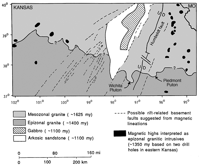
Figure 12--Index map showing relationship of southeastern Kansas and southeastern Missouri igneous complexes to the Ozark uplift. Dark areas in southeast Missouri are Precambrian outcrops.
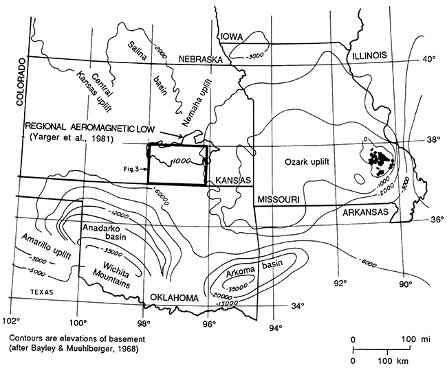
Along the east-west axis of the Ozark uplift in the 300-mi (480-km)-long zone lying between southeast Kansas and southeast Missouri (fig. 12), we may expect to find other Graniteville-type intrusions. Detailed aeromagnetic data will be required here for their identification, as this area is covered by a thick Paleozoic sequence. Topographically higher basement along this axis and possibly on the Ozark uplift itself may be due to isostatic buoyancy of lower density material of the acidic Graniteville-type intrusions.
In southeast Missouri, the lack of observed displacement of any of the Graniteville-type intrusive boundaries indicates a lack of subsequent tectonic movement, as mentioned previously. This area has apparently not been subjected to significant shearing stress for over 1,300 m.y. However, in one place in Kansas later displacement of a Graniteville-type intrusion can be documented. That is on the southwest boundary of the Wichita Pluton. Fig. 13 is a detailed residual aeromagnetic map of a 10 x 11-mi area (16 x 18 km) covering the pronounced bend in the boundary visible on the total-intensity aeromagnetic maps (figs. 1 and 3). The intrusive boundary is indicated in fig. 13 by a heavy dashed line following the steepened gradients. There is obvious offset of this boundary, and it is interpreted to have taken place along the northeast-striking faults indicated. The displacement is approximately 3 mi (4.8 km) in a left-lateral sense. The westernmost fault shown has been verified by oil-field studies (Shawver, 1965) and has post-Kinderhook (lower Mississippian) down-to-the-west throw. As no equivalent amounts of Paleozoic strike-slip movement are documented for southern Kansas, the strike-slip movement possibly occurred contemporaneously with the opening of the Precambrian midcontinent rift system at 1,100 m.y. B.P. before the deposition of the sedimentary rocks. The area is located about 80 km (48 mi) southeast of the southern terminus of the midcontinent rift, and the faults are nearly parallel to the rift at this location. The vertical movement on the faults, i.e. the formation of the horsts and grabens, documented by movement of the sedimentary rocks, possibly occurred during the Pennsylvanian Nemaha event.
Figure 13--Residual aeromagnetic map of the southwestern boundary of the Wichita granite pluton showing fault offsets. Contour interval = 2 gammas. (Location of this area appears on regional map of fig. 3.)
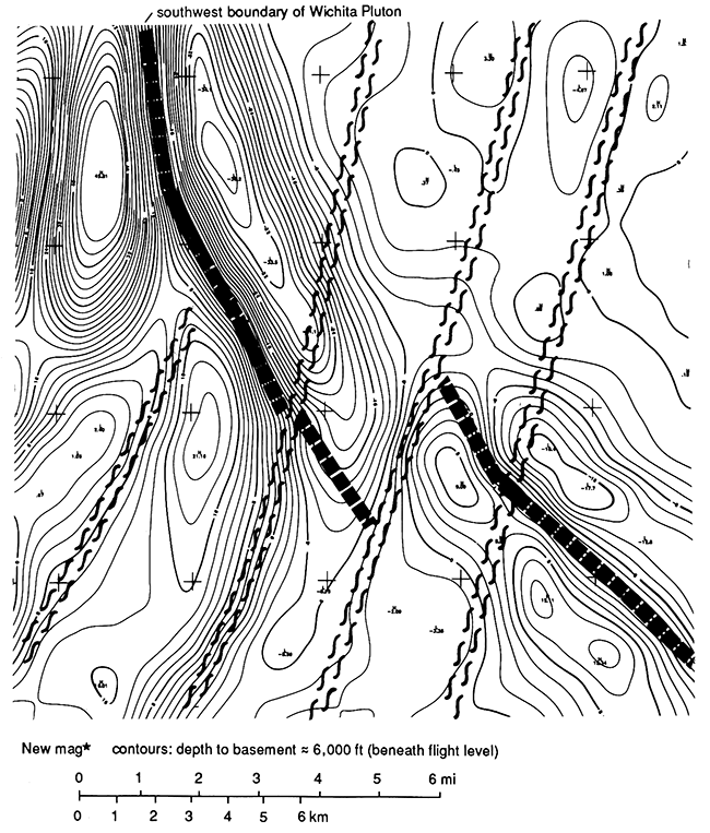
Fig. 13 also shows truncation of several north-northeasterly trending magnetic highs and lows over pre-existing basement blocks south of the intrusion. The detailed residual-magnetic data (not presented here) demonstrate that the Wichita Pluton truncated 11 such earlier trends. These appear to be metamorphic units similar to those penetrated in well intercepts in northern Sedgwick, Butler, and Greenwood counties, although they may be faulted and sheared granites or meta-granites. The age of these earlier rocks is in question, as I do not believe there was sufficient time to have created a complex of basement blocks composed of gneisses, schists, and meta-granites within 100-200 m.y. (Bickford et al., 1981) prior to emplacement of the Graniteville-type intrusions. Possibly earlier ages here are obscured by metamorphic overprinting.
In summary, a series of Graniteville-type intrusions has been recognized in southeastern Kansas that appears to be contemporaneous, and probably co-genetic, with similar intrusions in southeastern Missouri. The physical, chemical, geological, and geomorphological characteristics of these intrusions, as listed earlier, are probably also similar. This has implications not only for a basic scientific understanding of basement rocks in southeastern Kansas but also for oil and gas exploration in these areas due to basement topographic control of stratigraphy and structure in the overlying oil- and gas-bearing sedimentary section. Also, in later decades or centuries, the basement rocks of Kansas may be important sources of minerals, and the more complete our knowledge of basement geology, the sooner that time will come. Any Kansas-sized area (82,000 mi2; 213,200 km2) located in the outcropping portion of the North American craton, i.e. the Canadian Shield, contains ore deposits valued in many billions of dollars.
Allingham, J. W., 1964, Low amplitude aeromagnetic anomalies in southeastern Missouri: Geophysics, v. 29, no. 4, p. 537-552.
Bayley, R. W., and Muehlberger, W. R., 1968, Basement rock map of the United States: U.S. Geological Survey, scale 1:2,5000,000.
Bickford, M. E., Harrower, K. L., Nusbaum, R. L., Thomas, J. J., and Nelson, G. E., 1979, Preliminary geologic map of the Precambrian basement rocks of Kansas: Kansas Geological Survey, Map M-9, scale 1:500,000, 1 sheet. [available online]
Bickford, M. E., Harrower, K. L., Hoppe. W. J., Nelson, B. K., Nusbaum, R. L., and Thomas, J. J., 1981, Rb-Sr and U-Pb geochronology and distribution of rock types in the Precambrian basement of Missouri and Kansas: Geological Society of America, Bulletin, part 1, v. 92, no. 6, p. 323-341.
Bickford, M. E., and Mose, D. G., 1975, Geochronology of Pre cambrian rocks in the St. Francois Mountains, southeastern Missouri: Geology, v. 3, no. 9, p. 537-540.
Cole, V.B., and Ebanks, W.J., Jr., 1979, List of Kansas wells drilled into Precambrian rocks: Kansas Geological Survey, Subsurface Series 3, 107 p.
Criss, R. E., and Champion, D. E., 1984, Magnetic properties of granitic rocks from the southern half of the Idaho batholith--influences of hydrothermal alteration and implications for aeromagnetic interpretation: Journal of Geophysical Research, v. 89, no. B8, p. 7,061-7,076.
Gay, S. P., Jr., 1976, Aeromagnetic lineament study of covered Precambrian basement, southeastern Missouri; in, Proceedings of the First International Conference on Basement Tectonics, R. A. Hodgson et al., eds.: Utah Geological Association, Publication No.5, p. 183-191.
Kisvarsanyi, E. B., 1980, Granitic ring complexes and Precambrian hot-spot activity in the St. Francois terrane, midcontinent region, United States: Geology, v. 8, no. 1, p. 43-47.
Kisvarsanyi, E. B., 1981, Geology of the Precambrian St. Francois terrane, southeastern Missouri: Missouri Department of Natural Resources, Division of Geology and Land Survey, Report of Investigations, no. 64, 58 p.
Shawver, D. D., 1965, Gillian field, OSA field; in, Kansas Oil and Gas Fields: Kansas Geological Society, v. 4, p. 78-79, 175-184.
Snyder, F. R., and Wagner, R. E., 1961, Precambrian of southeast Missouri--status and problems; in, Guidebook to the Geology of the St. Francois Mountain Area: Missouri Geological Survey, Report of Investigation, no. 26, p. 84-94.
Tolman, C. F., and Robertson, F., 1969, Exposed Precambrian rocks in southeast Missouri: Missouri Geological Survey, Report of Investigation, no. 44, 68 p.
Van Schmus, W. R., and Bickford, M. E., 1981, Proterozoic chronology and evolution of the midcontinent region, North America; in, Precambrian Plate Tectonics, A. Kroner, ed.: Elsevier Scientific Publication Co., New York, p. 261-296.
Yarger, H. L., 1982, Kansas basement study using spectrally filtered aeromagnetic data: Paper presented at the 52nd Annual International Meeting, Society of Exploration Geophysicists, Dallas, Texas, 32 p., 13 illus.; (1983) Kansas Geological Survey, Open-file Report 83-9, 36 p.
Yarger, H. L., Robertson, R., Martin, J., Ng, K., Sooby, R., and Wentland, R., 1981, Aeromagnetic map of Kansas: Kansas Geological Survey, Map M-16, scale 1:500,000, 1 sheet.
Kansas Geological Survey
Comments to webadmin@kgs.ku.edu
Web version July 20, 2013. Original publication date 1989.
URL=http://www.kgs.ku.edu/Publications/Bulletins/226/Gay/index.html