![]()
Prev Page--Stratigraphy--Igneous || Next Page--Major Unconformities
Stratigraphy, continued
Precambrian Rocks
Precambrian rocks are not exposed in Kansas but are extensively known from well data. Approximately 2,300 wells are known to have penetrated the Precambrian basement rock complex, which is shallowest at about 600 feet, over the Nemaha ridge in northeastern Kansas, and deepest at about 9,500 feet in the Hugoton Embayment.
Sources of Information
Information concerning the wells that have reached the Precambrian in Kansas has been compiled from both published and unpublished sources. Reliability of information for each well, although it has been checked as thoroughly as possible, is dependent on its source. Of the information reported in the published lists (Cole and others, 1961; Cole and Merriam, 1962; Cole, Merriam, and Hambleton, 1963), that which deals with the type of basement rock is least reliable, because identifications range from a cursory glance by a driller to a minute, detailed examination by a petrographer.
Only two published works (Walters, 1946; Farquhar, 1957) yield detailed information concerning distribution of Precambrian lithologies. Other sources of published data are listed in a complete bibliography by Cole and others (1961). Unpublished data have been assembled from sample logs, logs of the Kansas Sample Log Service, and drillers logs. This information was made available by several Kansas state agencies and private industry. In fact, without the cooperation of the petroleum industry in the state, assembly of the Precambrian data would have been an insurmountable task. Some data based on petrographic study of samples and thin sections by O. C. Farquhar and P. C. Franks were also available.
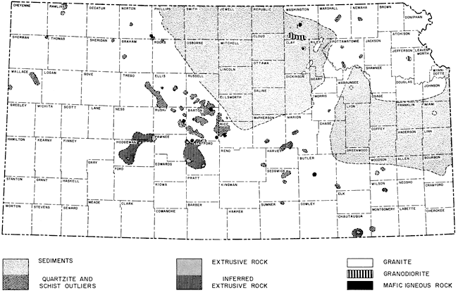
Because of the diversity of Precambrian rock types reported and because of the vagueness of much of the information available at this time, distribution of only a few major categories of rock types is shown on the accompanying map (Fig. 87). Exotic rock types, for the most part, are not shown separately, pending verification by further work. The tendency for drillers to report "granite," signifying futility of further exploratory drilling for oil or gas, gives rise to large areas of "granite" in Kansas that upon additional study no doubt will resolve into a more meaningful pattern.
Figure 87--Map of Kansas showing generalized Precambrian basement rock-type distribution based on about 2,200 wells (from Merriam, Cole, and Hambleton, 1961). An Acrobat PDF version of this figure is available.
Precambrian Rock Types
The Precambrian basement complex consists mainly of igneous and metamorphic rocks (Merriam, Cole, and Hambleton, 1961). The most often reported igneous rock is granite; the most often reported metamorphics are quartzite and schist. The overall distribution of rock types is at best only vaguely known, despite more than two thousand control points, because most of the wells are located along the crests of the Nemaha Anticline and Central Kansas Uplift. In vast areas in Kansas, no tests have been drilled to the basement, especially in basinal areas.
A weathered or detrital material known as "granite wash" covers large areas beneath Paleozoic sediments. In this report, the "granite wash" or pre-Reagan (Upper Cambrian) rocks are interpreted to be Precambrian in age. The arguments for assigning them to the Precambrian are beyond the scope of this report; suffice it to point out that no faunal evidence has been noted and that no Lower or Middle Cambrian sedimentary rocks are known in the Midcontinent area (Skillman, 1948).
Where several rock types have been reported in vertical succession, only the uppermost is shown. About 200 wells penetrate the basement to more than 100 feet; nine penetrate to more than 1,000 feet. The greatest penetration is reported to be 2,551 feet, in the Nemaha No. 1 Seneca well (sec. 19, T. 3. S., R. 11 E.) in Nemaha County.
The shallowest known Precambrian rocks encountered by test wells occur in northeastern Kansas, in Nemaha County, where the surface of the Precambrian rises to 588 feet above sea level; the deepest occurrence is in the southwest, in Barber County, at 4,595 feet below sea level. Additional exploration undoubtedly will reveal both shallower and deeper Precambrian in Kansas.
A wide band of thick, alternating hard and soft layered sediments trends northwestward across northeastern Kansas and constitutes a regional province (Fig. 87). Rock types reported from this province include: schist, quartzite, arkosic quartzite, arkose, undifferentiated metamorphics, clastics, gneiss, and "granite wash" (in thicknesses far exceeding that of "granite wash") which must be layered sediments. The continuity of the band is broken along the crest of the Nemaha Anticline in Pottawatomie County, southeastern Riley and Geary Counties, northwestern Wabaunsee County, and Morris County, where seemingly the sequence was removed prior to cover by younger units. Along the Nemaha, as well as to the northeast and southwest of the province, are outliers of sediments.
Included within the province are rock types that may prove to be either windows or igneous intrusions in the sediments. Evidence is lacking to suggest which interpretation, or both, is correct. These areas include mafic rocks, granodiorite, and granite. Sediments are absent along parts of the crest of the Abilene Anticline in northwestern Riley County and southeastern Clay County. [Note: Lyons (1959) believed that the Greenleaf maximum gravity anomaly in northeastern Kansas represens ". . . an extenaion of the sedimentary prism of the Lake Superior Syncline to the southwest, and that the sedimentary rocks have been intruded extensively by basic rocks, as in the Lake Superior region."
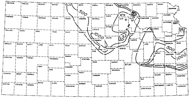
Thickness of these sediments and the lithology of the underlying rock are for the most part not known, but the sequence seemingly is underlain by granitic rock. The deepest penetration without encountering crystalline rock is almost 1,600 feet (Fig. 88). Comparable thicknesses are known in adjacent states, where the province is known to extend eastward into Missouri (Grenia, 1960) and northwestward into Nebraska.
From preliminary information it may be suggested that a recognizable sequence of bedded material, only slightly metamorphosed if at all, is present in the province. It may be further suggested that the beds dip gently, as in southwestern Missouri. In Vernon County, Missouri, just across the Kansas-Missouri line, gently dipping units could be recognized and traced between wells (Skillman, 1948).
Figure 88--Present known thickness of Precambrian sediments in northeastern and north-central Kansas. Thickness represent minimum values inasmuch as very few wells have penetrated to the "crystalline." Contour interval 500 feet.
Numerous outliers of metasediments composed mostly of quartzite and schist are located mainly along and adjacent to the Nemaha Anticline and Central Kansas Uplift. Some of the outliers along the Central Kansas Uplift are the famous buried Precambrian hills in northeastern Barton County which have been described in detail by Walters (1946). In his excellent paper on the origin and subsequent history of these hills, Walters wrote (1946, p. 660), "These flat-topped hills were quartzite monadnocks on a Cambrian peneplain eroded across pre-Cambrian quartzite, schist, granite, syenite, granite-gneiss, and pegmatite." Sufficient detail is available regarding this area to show the complexity of the basement.
Along the crest of the Central Kansas Uplift in Ellis, Russell, Rush, and Barton Counties, the Precambrian monadnocks are elongated northwestwardly. Two prominent trends may be noted, one in the position of the Rush Rib on the southwestern side of the uplift and the other along the Russell Rib. Of interest to the petroleum geologist is the fracture system in these metasediments, especially in the quartzites, that contain petroleum. In Kansas about 12 fields produce petroleum from rocks of Precambrian age.
Ten areas of mafic igneous rocks are known at present. In most places only one well penetrated this rock type although nearby wells encountered other Precambrian rock. Seemingly the areal extent of mafic rocks is very small. Most of the areas of mafic rock are located along the Cambridge Arch and the Central Kansas Uplift; two areas located just west of the Nemaha Anticline are exceptions. The association of this rock type and positive structural features strongly suggests a genetic relationship. These igneous bodies may have been emplaced along fracture systems developed in the rigid basement. Woollard (1959) found that the gravity anomalies are arranged parallel to structural features, suggesting structural control of intrusions along fracture lines.
The dark, mafic igneous rocks are described as peridotite, diabase, diorite, basalt, gabbro, mafic rock, and basic igneous rock. Much of the rock is weathered. The greatest penetration of this material is about 100 feet. In one well, mafic igneous rock was encountered below quartzite and granite.
Rock types described as rhyolite, felsite, rhyolite porphyry, felsite porphyry, and quartz porphyry are interpreted as extrusive rocks. So far as is known only one well, or a group of wells in a small area, encounters these rock types, which normally are structurally high. Several of these areas have been grouped together tentatively to indicate areas of possible genetically related suites.
The "flow" areas are all located adjacent to major structural units; the largest areas seemingly occur on the southwest flank of the Central Kansas Uplift. Like the mafic igneous rocks, these small bodies of structurally high extrusive material may represent feeder remnants, and if so, a basement fracture pattern may be discernible when additional data are available.
Two small areas of granodiorite have been reported in northeastern Kansas. Further study may show that large areas now reported to be granite are granodiorite.
By far the most common rock type reported in Kansas is granite or "granite wash." Granite is the most "popular" rock type because much granite has been found on uplifts where the Precambrian is shallow, and the term has become synonymous with Precambrian "bottom."
Many varieties of granite are present, and without doubt this province has a complex history. Descriptions of the granite are varied and include: red, coarsely crystalline, fractured granite; biotite granite, pink granite, pegmatitic granite, microgranite, syenitic granite, hornblende granite, gray granite, chloritized granite, and gneissic granite. It is impossible in this report to show geographic distribution of the many variants of granitic rock.
On the crests of upwarped areas, the granite is deeply weathered. Locally the rock may be weathered as deep as 150 feet, although 10 to 50 feet is more common. Part of this degeneration took place prior to cover by lower Paleozoic rocks, but most of it is the result of weathering and erosion of high positive structures formed or emphasized during the Wichita orogeny. In other areas, especially in the Hugoton Embayment, the Precambrian surface is clean, and lower Paleozoic rocks rest on unweathered granite.
No wells have penetrated through Precambrian granite. In southeastern Kansas several post-Precambrian intrusions are known and often are confused with the basement. Where "granite" is encountered at extremely shallow depths, it is possibly one of these small "plugs." Enough control is available now to show that in the extreme southeastern part of Kansas numerous Precambrian hills similar to those in northeastern Oklahoma rise above the general level of the basement floor as monadnocks (Ireland, 1955).
Farquhar recognized "earlier" and "later" granite. The "earlier" granite has a gneissic texture resulting from metamorphism; it is described as metamorphic, foliated, folded and interbanded with metasediments. The "later" granite is intrusive, and according to Farquhar is postmetamorphic, hypidiomorphic, and batholithic. The "later" granite is the most widespread rock type of the Precambrian (Farquhar, 1957, p. 82).
Several wells have reported syenite or syenitic granite, although these rock types have not been differentiated on the accompanying map. In most areas syenite was recorded from only one well even though surrounding tests also encountered Precambrian; therefore, it is assumed that its areal distribution is small. In the vicinity of the Central Kansas Uplift, the five wells encountering syenite are on two alignments both trending approximately N 55° W. This alignment suggests that the syenite is intrusive and perhaps was intruded along Precambrian zones of weakness. There is no evidence to suggest that the syenite is later than Precambrian.
Precambrian Age Dates
Potassium-argon ages of five samples from Barton, Rush, and Morris Counties were determined by J. L. Kulp of Lamont Geological Observatory of Columbia University (Table 3; Fig. 89). Dates obtained range from 1165 to 1460 million years, comparable to ages elsewhere in the central United States (J. L. Kulp, personal communication to W. W. Hambleton, 1961).
Figure 89--Location of wells from which samples were obtained for dating and ages determined by potassium-argon method.
Table 3--Potassium-argon dates of samples of Kansas Precambrian rocks.
| Well | Location | County | Rock type | Age, million years |
|---|---|---|---|---|
| Atlantic No. 10 "A" Patzner | E2 W2 SE sec. 36, T. 17 S., R. 11 W. | Barton | Altered chiastolite? schist | 1165 |
| Skelly No. 1 Betz | NE SE SW sec. 5, T. 18 S., R. 16 W. | Rush | Gneissic granite | 1260 |
| Skelly No. 4 Dyer | NE SE NW sec. 21, T. 18 S., R. 16 W. | Rush | Quartz-sericite schist | 1200 |
| Skelly No. 7 Schultz | NW NW NE sec. 5, T. 19 S., R. 15 W. | Barton | Quartz-sericite schist | 1460 |
| Leslie No. 1 "A" McConnell | SE SE SE sec. 14, T. 16 S., R. 9 E. | Morris | Muscovite quartzite | 1290 |
Prev Page--Stratigraphy--Igneous || Next Page--Major Unconformities
Kansas Geological Survey, Geologic History of Kansas
Comments to webadmin@kgs.ku.edu
Web version April 2006. Original publication date Dec. 1963.
URL=http://www.kgs.ku.edu/Publications/Bulletins/162/03_strat_e.html