Kansas Geological Survey, Bulletin 150, originally published in 1961
Next page—Table of Wells
Originally published in 1961 as Kansas Geological Survey Bulletin 150. This is, in general, the original text as published. The information has not been updated. An Acrobat PDF version (10.1 MB) is also available.
Information arranged by township and range concerning name, location, elevation, depth to Precambrian, total depth, Precambrian rock type, and rock unit overlying the Precambrian surface is included for each of approximately 2100 wells drilled to Precambrian rocks in Kansas through December 31, 1960.
Precambrian rocks are not exposed in Kansas, but are extensively known from well data. It is estimated that approximately 2100 wells have penetrated the Precambrian basement rock complex, which is within about 600 feet of the ground surface at the shallowest depth in northeastern Kansas and deepest at about 9,500 feet in the southwestern part of the state. Thus, the sedimentary strata appear only as a thin veneer over the basement complex, which is a buried extension of the Canadian Shield that is exposed farther to the north and northeast.
In Kansas, as throughout the Midcontinent region of the United States, structural development has been controlled in part by the Precambrian basement. The need for basement studies therefore has become increasingly evident. Detailed knowledge of basement configuration and lithology is essential to study of structural and stratigraphic traps for petroleum reserves in younger rocks; interpretation of geophysical anomalies is dependent upon critical basement data. Moreover, papers by Walters (1946, 1953), Walters and Price (1948), Landes (1939), and Landes and others (1960) have stressed the importance of petroleum production from basement rocks; and Lyons (1959) has suggested that the basement is an unexplored frontier in terms of mineral development.
Recognition of these problems by the American Association of Petroleum Geologists led to the appointment of a Basement Rocks Project Committee in February 1957 under the chairmanship of P. T. Flawn. This committee was charged with gathering data on available samples and cores of basement rocks, arranging for permanent storage of such material, encouragement of research and publication, and publication of basement maps. The State Geological Survey of Kansas, also recognizing need for basement studies, set up a basement study project; preliminary results were published by Farquhar (1957a). Further, a Basement Rocks Committee under the chairmanship of V. B. Cole was appointed by the Kansas Geological Society in 1958; the committee membership included P. C. Franks, D. D. Goodrich, W. W. Hambleton, P. L. Hilpman, E. A. Koester, and D. F. Merriam. [Note: Roy P. Lehman was appointed to the committee in 1961.] The objectives of this committee were to compile a complete list of wells drilled into the Precambrian rocks in Kansas, compile a basement configuration map based on these wells, and encourage study of basement lithology. The efforts of this committee were to be coordinated with those of the Basement Rocks Project Committee of the American Association of Petroleum Geologists to the extent of supplying well information for publication of a basement configuration map of North America. The present publication lists wells drilled into the basement in Kansas through 1960; it is a cooperative venture of the Kansas Geological Society and the State Geological Survey of Kansas.
It is anticipated that supplements to this list will be published at appropriate intervals in the future. Obviously, regardless of a concerted effort on the part of the committee, the list probably does not include all wells that penetrated Precambrian rocks in Kansas. Records of many wells believed to have been drilled in eastern Kansas are not available. Listings of these wells have been omitted except where verification could be made by personal communication. Records of some other wells have been omitted because of uncertainties as to location, elevation, and Precambrian penetration. Every effort will be made to keep the list of wells current, and additions will be made if omissions are discovered. Information that will make the record complete is solicited.
Under direction of the Kansas committee, a Precambrian configuration map is presently being compiled. This undertaking should be available in published form early in 1961. Much information in addition to authenticated Precambrian tests is being used in preparation of this map.
The Kansas Survey also is making a collection of thin sections of Precambrian rocks both from cuttings and core samples. Donations of cores or cuttings will be gratefully accepted.
The information will be kept on file in the offices of the Kansas Survey at The University of Kansas, Lawrence, and will be available to all interested students of Precambrian geology. As data accumulate, it is hoped that other basement studies will be started.
The number of individuals and companies that supplied information or helped assemble data for this list is so large that it is impossible to acknowledge individual contributions. Therefore, we extend to all concerned a most deserved and wholehearted thanks. We fully recognize that without the cooperation of the entire Kansas petroleum industry such an undertaking would be a much more difficult if not impossible task.
The Precambrian complex consists mainly of igneous and metamorphic rocks. Granite is by far the most extensive rock type recorded because: (1) granite is used synonymously with Precambrian to signify futility of further oil or gas exploratory drilling, and (2) most areas where Precambrian is shallow enough to be encountered occur on uplifts where the rocks are mainly granite. "Granite wash" is a term used for weathered or detrital material in a zone on the Precambrian surface. The age of this material varies from place to place depending on local geologic conditions.
[Note: In this report, in wells where Reagan is absent, "granite wash" is interpreted to be the top of pre-Reagan (Cambrian) rocks, or Precambrian. "Granite wash" is used also to describe rocks occurring below recognizable Reagan (Cambrian) sandstone and sandy dolomite; other terms used are arkose, arkosic sandstone, or "red clastics". Great thicknesses of such rocks have been penetrated in central Kansas (Ellsworth-Geneseo area), southeastern Nebraska, western and northwestern Missouri, and southwestern Iowa. The pre-Upper Cambrian sediments of very coarse and fine sand and shale containing traces of feldspar and mica are thought to be Precambrian rather than Lower of Middle Cambrian because: (1) there is lack of any faunal evidence, (2) "no lower or middle Cambrian sediments are known in the Midcontinent area" (Skillman, 1948).]
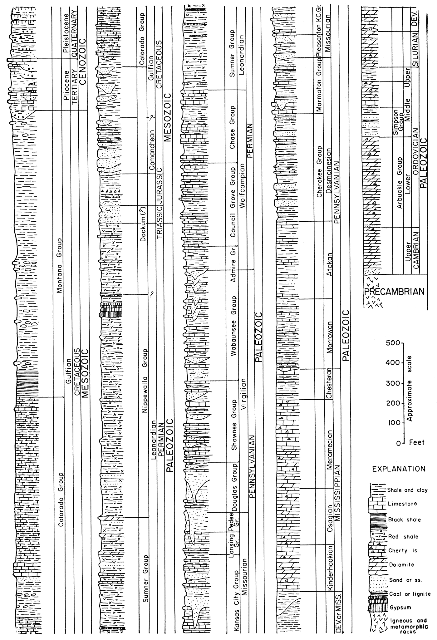
Only a few wells have been drilled into Precambrian rock in Kansas structural basins, but seemingly there are extensive areas of metamorphic rock. The distribution of different rock types is at best only poorly known. The stratigraphic relation of the Precambrian to younger sedimentary rocks in Kansas is diagrammatically depicted in Figure 1.
Figure 1—Composite stratigraphic column of rocks present in Kansas. (modified from Moore and others, 1952).
The overall composition of Precambrian rocks on a state-wide basis is summarized by Farquhar (1957a, p. 53):
The metamorphic group consists mainly of quartzite, granulite, schist, phyllite, and gneiss. Impure marble has been reported in two places. Some of the gneiss is metasedimentary, and some is foliated "earlier" granite, injected about the time of regional metamorphism. The intrusive suite is composed mostly of Precambrian "later" granite, but a few wells near the center of the state encounter gabbro and syenite, probably also Precambrian in age. Widely scattered minor intrusives include diabase and pegmatite.
Walters (1946) did much detailed work on the Precambrian in an area in Barton County in the central part of the state and found many rock types, including quartzite, schist, granite, syenite, granite-gneiss, and pegmatite. In addition to these rock types, rocks such as rhyolite and latite porphyry also have been encountered.
A major unconformity representing an erosional period of unknown duration occurs at the top of Precambrian rocks.
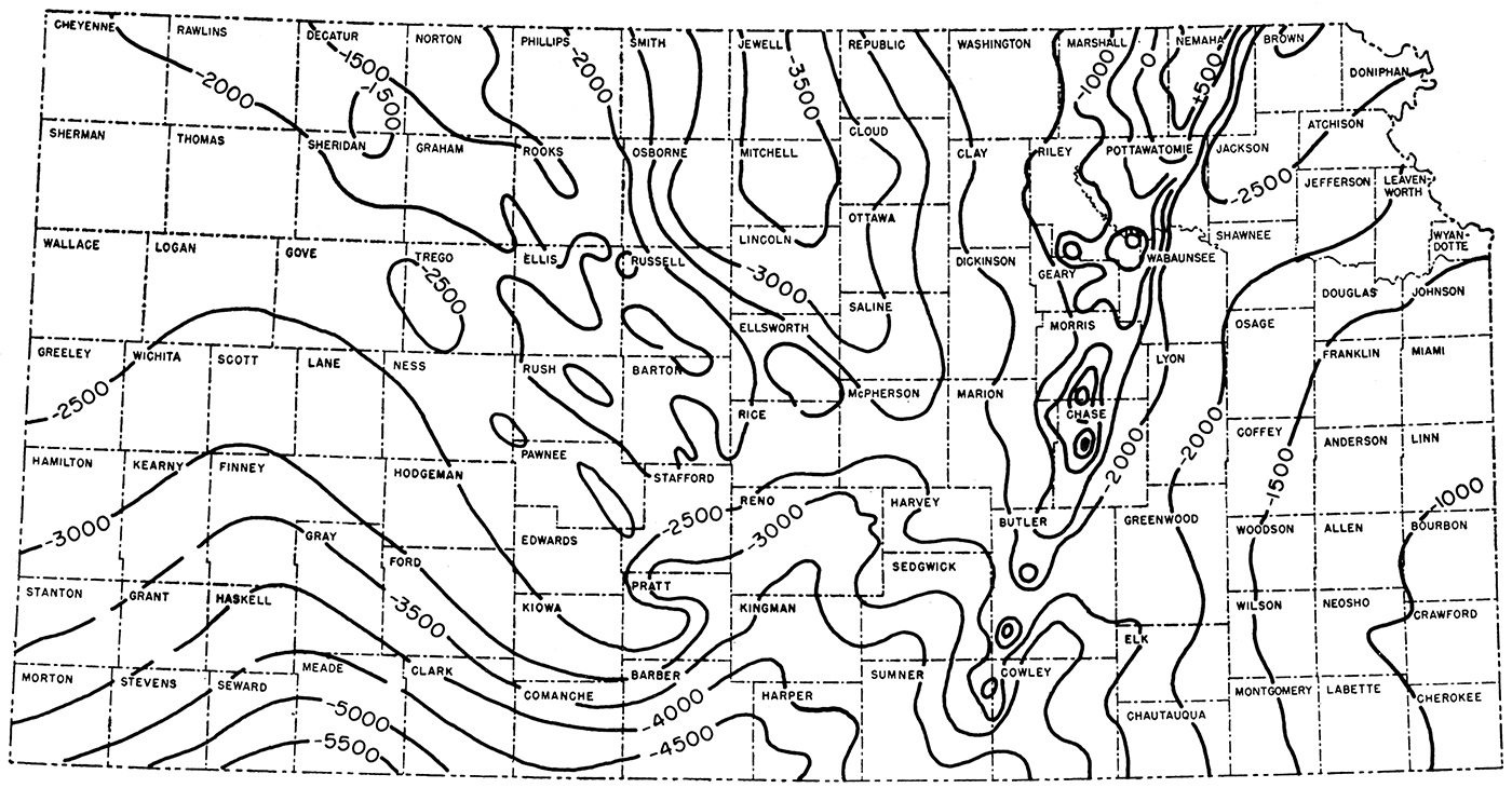
Many maps of the present configuration of the Precambrian in Kansas have been prepared and each successive map has been more detailed because of increased well control. The last published map is reproduced here (Figure 2) to show the generalized configuration. Farquhar, concerning the Precambrian surface, writes (1957a, p. 53):
Precambrian rocks have been affected by major movements in at least four Paleozoic and later periods. Principally in central and eastern Kansas, anticlinal structures have resulted from recurrent uplift. … Both the Precambrian surface and all overlying rocks in existence at the time when movement took place show the effect of that movement. Structures in post-Precambrian strata are controlled by irregularities of the uplifted Precambrian surface only locally, however, where this surface was temporarily exposed and eroded. Some degree of differential compaction of the post-Precambrian strata took place around buried Precambrian hills.
A new map is now being prepared from available information.
Figure 2—Contour map showing relief of Precambrian surface in Kansas, contour interval 500 feet, sea level datum (from Farquhar, 1957a). Configuration of contours reveals Nemaha Anticline extending from Nemaha County southwestward through Cowley County. Central Kansas Uplift (mainly in Russell, Ellis, Barton, and Rush Counties) and Cambridge Arch (Norton and Decatur Counties) are other prominent major "highs".
Abernathy, G. E. (1940) Oil and gas in Montgomery County, Kansas: Kansas Geol. Survey, Bull. 31, p. 1-29. [available online]
Abernathy, G. E. (1941) Ground-water resources of Mississippian and older rocks in Bourbon, Crawford, Cherokee, and Labette Counties, southeastern Kansas: Kansas Geol. Survey, Bull. 38, pt. 8, p. 221-236. [available online]
Allen, T. H., and Valerius, M. M. (1929) Fairport oil field, Russell County, Kansas; in, Structure of Typical American Oil Fields, v. 1: Am. Assoc. Petroleum Geologists, p. 35-48.
Aurin, F. L., Clark, G. C., and Trager, E. A. (1921) Notes on the subsurface pre-Pennsylvanian stratigraphy of the northern Midcontinent oil fields: Am. Assoc. Petroleum Geologists, Bull., v. 5, p. 117-153.
Barwick, J. S. (1928) The Salina Basin of north-central Kansas: Am. Assoc. Petroleum Geologists, Bull., v. 12, p. 177-199.
Bass, N. W. (1929) The geology of Cowley County, Kansas: Kansas Geol. Survey, Bull. 12, p. 1-203. [available online]
Cole, V. B., and Koester, E. A. (1946) Developments in north Midcontinent in 1945: Am. Assoc. Petroleum Geologists, Bull., v. 30, p. 895-901.
Collins, J. B. (1947) Subsurface geologic cross section from Trego County, Kansas, to Cheyenne County, Colorado: Kansas Geol, Survey Oil and Gas Invest. 5, cross sec. [available online]
Edson, F. C. (1945) Subsurface geologic cross section from Ford County to Wallace County, Kansas: Kansas Geol. Survey, Oil and Gas Invest. 1, cross sec. [available online]
Farquhar, O. C. (1957) List of Precambrian wells in Kansas, December 31, 1956: Kansas Geol. Survey open-file report, p. 1-162.
Farquhar, O. C. (1957a) The Precambrian rocks of Kansas: Kansas Geol. Survey, Bull. 127, pt. 3, p. 49-122. [available online]
Folger, Anthony (1933) Development of the oil and gas resources of Kansas in 1928 and 1929: Kansas Geol. Survey, Min. Res. Circ. 2, pt. 1, p. 1-105.
Goebel, E. D., and others (1956) Oil and gas developments in Kansas during 1955: Kansas Geol. Survey, Bull. 122, p. 1-249.
Goebel, E. D., and others (1957) Oil and gas developments in Kansas during 1956: Kansas Geol. Survey BuU. 128, p. 1-250.
Goebel, E. D., and others (1958) Oil and gas developments in Kansas during 1957: Kansas Geol. Survey, Bull. 133, p. 1-264.
Goebel, E. D., and others (1959) Oil and gas developments in Kansas during 1958: Kansas Geo!. Survey Bull. 138, p. 1-228.
Goebel, E. D., and others (1960) Oil and gas developments in Kansas during 1959: Kansas Geo!. Survey Bull. 147, p. 1-254.
Gould, C. N. (1923) Crystalline rocks of the plains: Geol, Soc. America Bull., v. 34, p. 541-560.
Greene, F. C. (1925) Granite wells in the northern Midcontinent region: Am. Assoc. Petroleum Geologists, Bull., v. 9, p. 351-354.
Hall, R. H. (1933) Development of the oil and gas resources of Kansas in 1930: Kansas Geol. Survey, Min. Res. Circ. 2, pt. 2, p. 107-174.
Hambleton, W. W., ed. (1959) Symposium on geophysics in Kansas: Kansas Geol. Survey, Bull. 137, p. 1-375. [available online]
Haworth, Erasmus (1908) Special report on oil and gas: Kansas Univ. Geol. Survey, v. 9, p. 1-586.
Haworth, Erasmus (1915) On crystalline rocks in Kansas: Kansas Geol. Survey, Bull. 2, p. 1-33. [available online]
Hiestand, T. C. (1935) Regional investigations, Oklahoma and Kansas: Am. Assoc. Petroleum Geologists, Bull.; v. 19, p. 948-970.
Hilpman, P. L. (1959) Petroleum hotspot report, Riley County, Kansas: Kansas Geol. Survey, p. 1-11.
Hilpman, P. L., and Goebel, E. D. (1960) Petroleum hotspot report, Geary County, Kansas: Kansas Geol. Survey, p. 1-10.
Ireland, H. A. (1955) Precambrian surface in northeastern Oklahoma and parts of adjacent states: Am. Assoc. Petroleum Geologists, Bull., v. 39, p. 468-483.
Jewett, J. M. (1941) The geology of Riley and Geary Counties, Kansas: Kansas Geol. Survey, Bull. 39, p. 1-164. [available online]
Jewett, J. M. (1954) Oil and gas in eastern Kansas: Kansas Geol. Survey, Bull. 104, p. 1-397.
Kansas Geological Society (1956) Kansas oil and gas pools, v. 1, southcentral Kansas, p. 1-100, Wichita.
Kansas Geological Society (1959) Kansas oil and gas fields, v. 2, western Kansas, p. 1-208, Wichita.
Kansas Geological Society (1960) Kansas oil and gas fields, v. 3, northeastern Kansas, p. 1-220, Wichita.
Kansas Geological Society Study Group (1951) West-east cross section, northern Kansas: Kansas Geol. Soc., Wichita, cross sec.
Kansas Geological Society Study Group (1956) North-south electrical log cross section, eastern Kansas: Kansas Geol. Soc., Wichita, cross sec.
Kansas Geological Society Study Group (1956a) West-east electrical log cross section, southeastern Kansas: Kansas Geol. Soc., Wichita, cross sec.
Kansas Oil Scouts Association (1943) Kansas oil and gas field development, 1942: National Oil Scouts and Landman's Assoc. Yearbook, v. 13, p. 187 -228.
Kansas Oil Scouts Association (1944) Kansas oil and gas field development, 1943: National Oil Scouts and Landman's Assoc. Yearbook, v. 14, p. 165-205.
Kansas Oil Scouts Association (1945) Kansas oil and gas field development, 1944: National Oil Scouts and Landman's Assoc. Yearbook, v. 15, p. 207-257.
Kansas Oil Scouts Association (1946) Kansas oil and gas field development, 1945: National Oil Scouts and Landman's Assoc. Yearbook, v. 16, p. 215-261.
Kansas Oil Scouts Association (1947) Kansas oil and gas field development, 1946: National Oil Scouts and Landman's Assoc. Yearbook, v. 17, p. 193-242.
Kansas Oil Scouts Association (1948) Kansas oil and gas field development, 1947: National Oil Scouts and Landman's Assoc. Yearbook, v. 18, p. 184-229.
Kansas Oil Scouts Association (1949) Kansas oil and gas field development, 1948: National Oil Scouts and Landman's Assoc. Yearbook, v. 19, p. 208-255.
Kansas Oil Scouts Association (1950) Kansas oil and gas field development, 1949: National Oil Scouts and Landman's Assoc. Yearbook, v. 20, p. 225-278.
Kansas Oil Scouts Association (1951) Kansas oil and gas field development, 1950: National Oil Scouts and Landman's Assoc. Yearbook, v. 21, p. 224-274.
Kansas Oil Scouts Association (1953) Kansas oil and gas field development, 1952: National Oil Scouts and Landman's Assoc. Yearbook, v. 23, p. 224-297.
Kansas Oil Scouts Association (1954) Kansas oil and gas field development, 1953: National Oil Scouts and Landman's Assoc. Yearbook, v. 24, p. 211-280.
Kansas Oil Scouts Association (1955) Kansas oil and gas field development, 1954: National Oil Scouts and Landman's Assoc. Yearbook, v. 25, p. 251-325.
Kansas Oil Scouts Association (1956) Kansas oil and gas field development, 1955: National Oil Scouts and Landman's Assoc. Yearbook, v. 26, p. 257-330.
Kansas Oil Scouts Association (1957) Kansas oil and gas field development, 1956: National Oil Scouts and Landman's Assoc. Yearbook, v. 27, p. 256-338.
Kansas Oil Scouts Association (1958) Kansas oil and gas field development, 1957: National Oil Scouts and Landman's Assoc. Yearbook, v. 28, p. 230.,.296.
Kansas Oil Scouts Association (1959) Kansas oil and gas field development, 1958: National Oil Scouts and Landman's Assoc. Yearbook, v. 29, p. 259-328.
Kansas Oil Scouts Association (1960) Kansas oil and gas development, 1959, Kansas Central: Internat. Oil Scouts Assoc., v. 30, pt. 1, p. 171-207.
Kellett, Betty (1932) Geologic cross section from western Missouri to western Kansas: Kansas Geol. Soc., Wichita, cross sec.
Keroher, R. P., and Kirby, J. J. (1948) Upper Cambrian and Lower Ordovician rocks in Kansas: Kansas Geol. Survey, Bull. 72, p. 1-140. [available online]
King, W. R. (1956) Pre-Permian handbook of the Hugoton Embayment: Liberal Geol. Soc., Liberal, Kansas, p. 1-212.
Koester, E. A. (1934) Development of the oil and gas resources of Kansas in 1931 and 1932: Kansas Geol. Survey, Min. Res. Circ. 3, p. 1-76.
Kornfeld, J. A. (1941) Stratigraphic traps source of major production over central Kansas uplift: Oil Weekly, v. 100, no. 6, p. 13-19, and no. 7, p.20-30.
Kulstad, R. O. and others (1958) Mineral resources of Elk County, Kansas: Kansas Geol. Survey, v. 14, pt. 2, p. 27-37. [available online]
Landes, K. K. (1927) A petrographic study of Precambrian of Kansas: Am. Assoc. Petroleum Geologists, Bull., v. 11, p. 821-824.
Landes, K. K. (1939) Oil production from Precambrian rocks in Kansas (abstract): Oil Weekly, v. 93, no. 3, p. 74.
Landes, K. K., and Keroher, R. P. (1938) Geology and oil and gas resources of Rush County: Kansas Geol. Survey, Min. Res. Circ. 4, p. 1-31. [available online]
Landes, K. K., and Keroher, R. P. (1939) Geology and oil and gas resources of Logan, Gove, and Trego Counties, Kansas: Kansas Geol. Survey, Min. Res. Circ. 11, p. 1-45. [available online]
Landes, K. K., and Keroher, R. P. (1942) Mineral resources of Phillips County: Kansas Geol. Survey, Bull. 41, pt. 8, p. 277-312. [available online]
Landes, K. K., and others (1960) Petroleum resources in basement rocks: Am. Assoc. Petroleum Geologists, Bull., v. 44, p. 1682-1691.
Lang, A. J., and Ver Wiebe, W. A. (1954) Unusual rock in Hodgernan County, Kansas: Wichita Univ. Bull., Univ. Studies 30, v. 29, no. 4, p. 1-4.
Lee, Wallace (1943) The stratigraphy and structural development of the Forest City Basin in Kansas: Kansas Geol. Survey, Bull. 51, p. 1-142. [available online]
Lee, Wallace (1956) Stratigraphy and structural development of the Salina Basin Area: Kansas Geol. Survey, Bull. 121, p. 1-167. [available online]
Lee, Wallace, and Merriam, D. F. (1954) Cross sections in eastern Kansas: Kansas Geol. Survey, Oil and Gas Invest. 12, p. 1-8. [available online]
Lyons, Paul L. (1959) The Greenleaf anomaly, a significant gravity feature; in, Symposium on Geophysics in Kansas, W. W. Hambleton, ed.: Kansas Geol. Survey, Bull. 137, p. 105-120. [available online]
Maher, J. C. (1946) Subsurface geologic cross section from Ness County, Kansas, to Lincoln County, Colorado: Kansas Geol. Survey, Oil and Gas Invest. 2, cross sec. [available online]
Maher, J. C., and Collins, J. B. (1949) Pre-Pennsylvanian geology of southwestern Kansas, southeastern Colorado, and the Oklahoma Panhandle: U.S. Geological Survey, Oil and Gas Invest., Prelim. Map 101, 4 sheets. [available online]
Martz, W. H., Jr. (1960) Developments in north Midcontinent in 1959: Am. Assoc. Petroleum Geologists, Bull., v. 44, p. 742-751.
Merriam, D. F., and Atkinson, W. R. (1955) Tectonic history of the Cambridge Arch in Kansas: Kansas Geol. Survey, Oil and Gas Invest. 13, p. 1-28. [available online]
Merriam, D. F., and Goebel, E. D. (1954) The geology of the Norton oil field, Norton County, Kansas: Kansas Geol. Survey, Bull. 109, pt. 9, p. 125-152. [available online]
Merriam, D. F., and Hambleton, W. W. (1956) Relation of an airborne magnetic profile to the geology along the Kansas-Nebraska border: Kansas Geol. Survey, Bull. 119, pt. 7, p. 251-266. [available online]
Mettner, F. E. (1936) The Precambrian basement complex of Kansas: Unpublished MS thesis, Kansas Univ., p. 1-59.
Moore, R. C. (1918) Geologic history of the crystalline rocks of Kansas: Am. Assoc. Petroleum Geologists, Bull., v. 2, p. 98-113.
Moore, R. C., and Haynes, W. P. (1917) Oil and gas resources of Kansas: Kansas Geol. Survey, Bull. 3, p. 1-391. [available online]
Moore, R. C., and others (1952) Graphic column of Kansas rocks: Kansas Geol. Survey, chart.
Moss, R. G. (1936) Buried Precambrian surface in the United States: Geol. Soc. America Bull., v. 47, p. 935-966.
Moss, R. G. (1938) Developments in Kansas in 1937: Am. Assoc. Petroleum Geologists, Bull., v. 22, p. 666-676.
Ockerman, J. W. (1935) Subsurface studies in northeastern Kansas: Kansas Geol. Survey, Bull. 20, p. 1-78. [available online]
O'Connor, H. G., and others (1951) Mineral resources of Chase County, Kansas: Kansas Geol. Survey, v. 11, pt. 2, p. 16-28. [available online]
O'Connor, H. G., and others (1953) Mineral resources of Lyon County, Kansas: Kansas Geol. Survey, v. 12, pt. 2, p. 24-35. [available online]
O'Connor, H. G., and others (1955) Mineral resources of Osage County, Kansas: Kansas Geol. Survey, v. 13, pt. 2, p. 20-28. [available online]
Powers, Sidney (1917) Granites in Kansas: Am. Jour. Sci., ser. 4, v. 44, p. 146-150.
Powers, Sidney (1922) Reflected buried hills and their importance in petroleum geology: Econ. Geology, v. 17, p. 233-~59.
Schramm, E. F. (1931) Precambrian wells; in, Deep wells of Nebraska, G. E. Condra, E. F. Schramm, and A. L. Lugn, ed.: Nebraska Geol. Survey, Bull. 4, 2d ser., p. 281-286.
Skillman, M. W. (1948) Pre-Upper Cambrian sediments of Vernon County, Missouri: Missouri Geol. Survey, Rept. Invest. 7, p. 1-18.
Smith, R. K., and Anders, E. L. Jr. (1951) The geology of the Davis Ranch oil pool, Wabaunsee County, Kansas: Kansas Geol. Survey, Bull. 90, pt. 2, p. 13-52. [available online]
Taylor, C. H. (1917) The granites of Kansas: Southwestern Assoc. Petroleum Geologists Bull., v. 1, p. 111-126.
Thomas, C. R. (1929) Flank production of the Nemaha Mountains (Granite Ridge) Kansas; in, Structure of Typical American Oil Fields, v. 1: Am. Assoc. Petroleum Geologists, p. 60-72.
Ver Wiebe, W. A. (1938) Oil and gas resources of western Kansas: Kansas Geol. Survey, Min. Res. Circ. 10, p. 1-179.
Ver Wiebe, W. A. (1939) Western Kansas oil and gas developments during 1938: Kansas Geol. Survey, Min. Res. Circ. 13, p. 1-106.
Ver Wiebe, W. A. (1940) Exploration for oil and gas in western Kansas during 1939: Kansas Geol. Survey, Bull. 28, p. 1-106.
Ver Wiebe, W. A. (1941) Exploration for oil and gas in western Kansas during 1940: Kansas Geol. Survey, Bull. 36, p. 1-109.
Ver Wiebe, W. A. (1942) Exploration for oil and gas in western Kansas during 1941: Kansas Geol. Survey, Bull. 42, p. 1-123.
Ver Wiebe, W. A. (1943) Exploration for oil and gas in western Kansas during 1942: Kansas Geol. Survey, Bull. 48, p. 1-88.
Ver Wiebe, W. A. (1944) Exploration for oil and gas in western Kansas during 1943: Kansas Geol. Survey, Bull. 54, p. 1-104.
Ver Wiebe, W. A. (1945) Exploration for oil and gas in western Kansas during 1944: Kansas Geol. Survey, Bull. 56, p. 1-112.
Ver Wiebe, W. A. (1946) Exploration for oil and gas in western Kansas during 1945: Kansas Geol. Survey, Bull. 62, p. 1-112.
Ver Wiebe, W. A. (1947) Exploration for oil and gas in western Kansas during 1946: Kansas Geol. Survey, Bull. 68, p. 1-111.
Ver Wiebe, W. A., and others (1948) Oil and gas developments in Kansas during 1947: Kansas Geol. Survey, Bull. 75, p. 1-230.
Ver Wiebe, W. A., and others (1949) Oil and gas developments in Kansas during 1948: Kansas Geol. Survey, Bull. 78, p. 1-186.
Ver Wiebe, W. A., and others (1950) Oil and gas developments in Kansas during 1949: Kansas Geol. Survey, Bull. 87, p. 1-176.
Ver Wiebe, W. A., and others (1951) Oil and gas developments in Kansas during 1950: Kansas Geol. Survey, Bull. 92, p. 1-187.
Ver Wiebe, W. A., and others (1952) Oil and gas developments in Kansas during 1951: Kansas Geol. Survey, Bull. 97, p. 1-188.
Ver Wiebe, W. A., and others (1953) Oil and gas developments in Kansas during 1952: Kansas Geol. Survey, Bull. 103, p. 1-201.
Ver Wiebe, W. A., and others (1954) Oil and gas developments in Kansas during 1953: Kansas Geol. Survey, Bull. 107, p. 1-204.
Ver Wiebe, W. A., and others (1955) Oil and gas developments in Kansas during 1954: Kansas Geol. Survey, Bull. 112, p. 1-215.
Walters, R. F. (1946) Buried Precambrian hills in northeastern Barton County, central Kansas: Am. Assoc. Petroleum Geologists, Bull., v. 30, p. 660-710.
Walters, R. F. (1953) Oil production from fractured Precambrian basement rocks in central Kansas: Am. Assoc. Petroleum Geologists, Bull., v. 37, p. 300-313.
Walters, R. F., and Price, A. S. (1948) Kraft-Prusa oil field, Barton County, Kansas; in, Structure of Typical American Oil Fields, v. 3: Am. Assoc. Petroleum Geologists, p. 249-280.
Williams, G. Q. (1954) Developments in north Midcontinent in 1953: Am. Assoc. Petroleum Geologists, Bull., v. 38, p. 1107-1119.
Williams, G. Q. (1955) Developments in north Midcontinent in 1954: Am. Assoc. Petroleum Geologists, Bull., v. 39, p. 879-890.
Williams, G. Q. (1956) Developments in north Midcontinent in 1955: Am. Assoc. Petroleum Geologists, Bull., v. 40, p. 1138-1151.
Williams, G. Q. (1957) Developments in north Midcontinent in 1956: Am. Assoc. Petroleum Geologists, Bull., v. 41, p. 1074-1088.
Williams, G. Q. (1958) Developments in north Midcontinent in 1957: Am. Assoc. Petroleum Geologists, Bull., v. 42, p. 1207-1219.
Williams, G. Q. (1959) Developments in north Midcontinent in 1958: Am. Assoc. Petroleum Geologists, Bull., v. 43, p. 1208-1220.
Wright, Park (1918) Granite in Kansas wells: Am. Inst. Min. Eng. Trans., v. 57, p. 906-913.
Young, J. Y. (1960) Kansas oil and gas development, 1959, Kansas northwest: Internat. Oil Scouts Assoc., v. 30, pt. 1, p. 208-212.
Next page—Table of Wells
Kansas Geological Survey
Placed on web Dec. 15, 2018; originally published April 1961.
Comments to webadmin@kgs.ku.edu
The URL for this page is http://www.kgs.ku.edu/Publications/Bulletins/150/index.html