Kansas Geological Survey, OGI 2
Originally published in 1946 as Kansas Geological Survey Oil and Gas Investigations 2. This is, in general, the original text as published. The information has not been updated. An Acrobat PDF version (29.5 MB) is also available.
Stratigraphic investigations designed to assist in the search for oil and gas in western Kansas, eastern Colorado, and in parts of the adjacent states were begun in the fall of 1943 by the Geological Survey, U.S. Department of the Interior. Up to the present the investigations have been made principally in the area south of T. 12 S. and west of R. 20 W., Kansas, which includes southwestern Kansas, southeastern Colorado, part of the Panhandle of Oklahoma and the Panhandle of Texas. The chief purpose of the work is to correlate the subsurface beds in this area with the formations, particularly those that yield oil and gas, in the oil fields of central Kansas. The results of the studies are being presented as a series of regional cross sections published by the State Geological Survey of Kansas. This cross section, the second in the series, extends from the Sinclair Prairie Oil Company No. 1 Wilhelm well, in the center of the SW SW sec. 16, T. 19 S., R. 21 W., Ness County, Kansas, westward to the Gulf Oil Corporation No. 1 U. P.-Smith well, in the center of the SW SE sec. 19, T. 15 S., R. 53 W., Lincoln County, Colorado. It includes 12 wells, numbered from west to east, as shown on the index map.
This investigation has been aided by the cooperation of many geologists and oil companies. The well cuttings on which the work is based were generously loaned by the oil companies and the State Geological Survey of Kansas. The microfossils in the cuttings were identified by L. G. Henbest; the macrofossils in cores, by J. W. Huddle. Valuable criteria for establishing the subdivisions of the Mississippian rocks were contributed by Wallace Lee and A. J. Crowley. The writer is indebted to H. D. Miser and N. W. Bass for their suggestions and careful review of the cross section and text.
The subsurface stratigraphy of the central Kansas oil fields has been well established through years of work by petroleum geologists examining samples from thousands of wells and outcrops. Many of the smaller units of the Permian and Pennsylvanian systems described on the surface in central and eastern Kansas, and most of the major subdivisions of the Mississippian, Silurian, Devonian, Ordovician, and Cambrian systems recognized in Missouri, Iowa, and Oklahoma have been identified in the wells, and their terminology is generally agreed upon by Kansas petroleum geologists. These subsurface units have been accepted in this investigation as a basis for extending correlations into eastern Colorado. The correlations were carried westward well by well through detailed microscopic examination of cuttings from selected wells located at intervals of 8 to 33 miles.
The microscopic examination of the cuttings consisted of describing the kind and character of the rocks by their color, hardness, texture (including crystallinity, or size, shape, and degree of sorting and abrasion), mineral composition, bond or cementing material, and the type and characteristics of inclusions such as chert, oolites, casts, microfossils, glauconite, pyrite, calcite, siderite, and sphalerite. The characteristics of some of these rocks are distinctive enough so that thin key beds may be traced over great distances. These key beds assisted in the recognition of large sequences of less distinctive or less persistent strata.
Most of the wells in western Kansas and eastern Colorado have been drilled by rotary methods, which do not permit accurate sampling of the formations penetrated except where cores were procured. Each sample of rotary cuttings contains fragments of many different kinds of rock, most of which have been cut at shallower depth than that at which the sample was collected. Usually only a small part of the sample represents the rock actually drilled at the depth marked on the sample container. Therefore the logging of such samples consists of describing for a given interval only that type of rock that has not appeared in the samples at shallower depth and which the geologist believes belongs in that interval. Because this involves interpretation, the logs prepared from rotary cuttings are subject to the personal equation of the geologist, and complete agreement on details cannot be expected.
In the preparation of this cross section the sample logs were drawn on a vertical scale of 1 inch equals 100 feet and were reduced to 1 inch equals 200 feet on the published chart. The logs are aligned on sea-level datum and the horizontal scale between wells is 1 inch equals 6 miles. The vertical exaggeration of the section is 158.4 times. This exaggeration permitted the representation of most stratigraphic units, but not all the finer details serving to differentiate those units could be shown.
Electric logs of wells 2, 6, and 11 were plotted on the section to illustrate the close correspondence between the electric logs and the sample logs and to show the relation of the distinctive markers on the electric logs to the geologic formations identified in the samples. The sample logs were prepared without reference to the electric logs and no adjustments have been made. Comparison of the two types of logs reveals that generally the recorded depth of a given bed is slightly less on the electric log than on the sample log. This difference is explained by the fact that the sampling at the surface lags behind the actual cutting of the given bed at depth. Depth corrections or adjustments can be made on the sample log if the electric log is at hand while the samples are being examined. The use of electric logs in Kansas has been retarded somewhat by the poor results obtained in the areas underlain by thick Permian salt beds. The effect of excessively saline drilling mud resulting from the penetration of the thick Hutchinson salt may be seen by comparing the less distinct curves of the electric log of well 11 with the curves of the electric logs of wells 2 and 6. In recent years the masking effect produced by the salt has been greatly reduced by setting casing through the salt bed and by. changing the mud in the hole before making the electric survey.
Rocks of Tertiary and Upper Cretaceous age are present at the surface throughout the region traversed by this cross section. These rocks are underlain by Lower Cretaceous, Jurassic, Triassic (?), Permian, Pennsylvanian, Mississippian, Ordovician, and Cambrian sedimentary rocks resting upon pre-Cambrian igneous and metamorphic rocks. The thickness of the sedimentary rocks is about 5,000 feet in Ness County, Kansas, at the east end of the section, and greater than 7,000 feet in Lincoln County, Colorado, at the west end of the section. Only the Paleozoic rocks were studied in this investigation; they are described herein beginning with the youngest.
A major erosional unconformity is present at the top of the Permian system, which lies at depths ranging from 850 feet at the east end of the section to 2,950 feet at the west end. The Permian rocks consist of marine beds of limestone, dolomite, and shale overlain by thick continental deposits of anhydrite, salt, red shale and sandstone. The marine facies is thin in eastern Colorado. The thickness of the Permian rocks decreases westward from 2,410 feet in well 6, where nearly a complete section exists, to 1,472 feet in well 2, where most of the Guadalupian series is absent.
The Guadalupian series consists of the Taloga formation, the Day Creek dolomite, and the Whitehorse sandstone. The series is present in wells 1 to 7 and in wells 9 and 10, where its thickness ranges from 87 to 395 feet. The Taloga formation is represented only in wells 4 and 5 where it consists of red silty and sandy shale and thin beds of anhydrite. The Day Creek dolomite, about 20 to 30 feet thick, is present eastward from well 4 to well 7. The formation grades from well to well from buff dolomite into white anhydrite. The Whitehorse sandstone consists of fine red silty sand and shale and thin stringers of dolomite and anhydrite; it is the most extensive formation of the Guadalupian series, being present in wells 1 to 7, 9, and 10. It is possible that the upper sandy phase shown tentatively as Whitehorse sandstone in wells 1 and 2 may be younger than Permian.
Nippewalla group
The Nippewalla group, ranging from 318 to 790 feet in thickness, includes six formations, not all of which can be readily identified in the subsurface. The presence of an unconformity of regional significance at the top of this group, a subject of controversy among geologists in the past, could not be proved or disproved by this investigation. Therefore, conformable relations are indicated on the cross section, which accords with the usage of the State Geological Survey of Kansas. The Dog Creek shale and Blaine formation at the top of the group seem to be a single unit, 55 to 235 feet thick, consisting chiefly of beds of anhydrite and red shale. The upper part of the unit is predominantly red shale in a few wells. The lower part of the unit is mostly white and pink crystalline anhydrite and thin beds of red argillite. Thin salt beds are present in the lower part in some wells. This unit constitutes an excellent subsurface key bed and was easily identified westward from well 11 on the southwest flank of the Central Kansas uplift to well 3 on the east flank of the Las Animas arch. It is less distinctive west of well 3, and the correlation in wells 1 and 2 is only tentative.
The Flowerpot shale, a soft gypsiferous maroon shale, is distinguishable from beds underlying it in wells in the eastern part of the area traversed by this section but was not definitely identified in the area west of well 6. The Cedar Hills sandstone, Salt Plain formation, and Harper sandstone of the Nippewalla group are not differentiated on the section. They are included in an irregular sequence of thick beds of red sandy shale and fine silty sand containing lenses of salt and anhydrite and thin stringers of dolomite. Facies changes in relatively short distances are so common in these formations that separation of them on the basis of lithology is of little value. The presence of orange polished round sand grains in the Cedar Hills sandstone is worthy of note, but is not unique. The considerable thickness of salt present in wells 5 and 6 is believed to represent a part of the Salt Plain formation.
Sumner group
In general the Sumner group thins westward from a little more than 800 feet in well 11 to 250 feet in well 2. The top of the group is marked by the Stone Corral dolomite, which ranges from 30 to 96 feet in thickness. Some evidence that suggests the possible presence of a minor unconformity above the Stone Corral dolomite was found. This formation consists predominantly of dolomite on the outcrop, but in the subsurface it is mostly white crystalline anhydrite and is commonly called the "Cimarron anhydrite." Thin beds of maroon shale, salt, and gray-buff dolomite are associated with the anhydrite beds. The Stone Corral is a good marker bed and was readily identified in all wells on the cross section except wells 1 and 2.
The Ninnescah shale is composed chiefly of red and brown shale and thin beds of sandstone, dolomite, and fibrous gypsum. The sandy phases predominate in the westernmost part of the area. The differentiation of these beds from similar beds in the underlying Wellington formation on the basis of color is not very satisfactory, because red shale is not restricted to the Ninnescah and gray shale is not confined to the Wellington, which is reported to be the condition on the outcrop. An unconformity may intervene between the Ninnescah and Wellington formations, as its presence is suggested by the irregular thickness of the two formations in the western area of the section.
The upper part of the Wellington formation contains red and gray shale with many thin anhydrite beds. The lower part is dominantly salt and anhydrite. The salt sequence, known as the Hutchinson salt, is 140 to 200 feet thick in the eastern part of the area and wedges out westward between wells 9 and 10. A few thin dolomites are distributed through the sequence. Except for a 20- to 30-foot bed of anhydrite which may mark the top of the Wellington formation, the beds are sandy in the wells near the Las Animas arch. The Hollenberg limestone which lies near the base of the Wellington formation was identified in well 12.
Chase group
The Chase group is composed of 290 to 380 feet of alternating thick beds of limestone and thin beds of shale which grade westward into red shale, sandstone, and thin dolomite beds, losing their identity near the Kansas-Colorado state line. The Nolans limestone, which is the top formation of the group and includes the Herington limestone member, consists chiefly of gray-buff slightly cherty and oolicastic dolomite. West of well 5, it grades into red shale and sand with a thin bed of dolomite and anhydrite at its top.
The Winfield limestone is a buff granular dolomite containing some gray subvitreous chert. It grades into thin beds of dolomite and shale in wells 5 and 6, and, west of well 5, loses its identity in the red shales and sands of the Chase and Council Grove groups.
In the eastern wells of the section, the Fort Riley limestone consists of cream- to buff-colored dolomitic limestone and minor amounts of white to gray opaque chert. Some oolicastic beds occur locally in the limestone. The member thins westward and disappears as an identifiable unit between wells 5 and 4. A bed of sandy dolomitic shale separates the Fort Riley from the underlying Florence limestone.
The Florence limestone is a light-gray dolomitic limestone that contains variable amounts of gray to black chert east of R. 33 W. In well 5 the Florence grades into dolomitic shale and sandstone.
The Wreford limestone consists of cream-buff to tan limestone containing white to gray opaque chert. It loses its cherty character westward and, west of well 4, is represented by sandy dolomitic shale.
Council Grove group
An angular unconformity marks the top of the Council Grove group. The group includes many thin beds of limestone and thick beds of shale. Only the Beattie, Grenola, and Foraker formations are distinctive enough in the subsurface to serve as correlation-marker beds. Where it is separable from the overlying Chase group, the thickness of the Council Grove group ranges from 257 to 367 feet. It thins westward and, west of well 5, grades into red shale containing thin limestone members. The limestone beds in the lower part of the group seem to extend across the Las Animas arch.
The Beattie limestone was identified in most of the eastern wells by its chalky cream color and the presence of weathered fusulinids embedded in its basal member, the Cottonwood limestone. In wells 8 to 11 maroon to gray shale containing varying amounts of sand and weathered chert underlies this limestone and overlies an angular unconformity, perhaps local in extent.
The top of the Grenola limestone is marked by the cream-colored chalky fossiliferous Neva limestone which is slightly cherty and oolicastic in some wells. Brachiopods, ostracodes, corals, and fusulinids are common in this bed. The Neva is not named on the section because its lower boundary could not be identified. The lower part of the Grenola consists of gray shale and gray marly limestone containing some fossils.
The Foraker limestone, the oldest formation of the Council Grove group, consists of several beds of massive gray limestone containing gray to black chert and some oolicasts, The basal limestone member, the Americus, contains fusulinids and black chert. The limestone beds of the Foraker definitely persist as far west as well 4 and probably as far as well 1. This is the youngest thick marine bed penetrated in the wells west of the state line.
Admire group
The Admire group is chiefly clastic and represents the initial deposits of the Permian system. In general the group is very irregular in thickness; it thins westward from 210 feet in well 10 to less than 50 feet in well 1. Thin beds of gray fossiliferous limestone and thick beds of shale occupy the upper part of the group; the lower part contains several beds of maroon and green shale and lenses of sandstone. A thick sandstone called the Indian Cave sandstone (not named on the section) is present at the base of the group in some of the eastern wells. This sandstone overlies the erosional unconformity that lies between Pennsylvanian and Permian rocks.
The Pennsylvanian system consists of a dominantly marine sequence of interbedded limestone and shale, and minor amounts of sandstone. These rocks are 1,200 feet thick in well 12 on the southwest flank of the Central Kansas uplift. They thin westward to 1,030 feet in well 8 near the crest of an unnamed anticline in eastern Scott County, Kansas, and thence thicken uniformly westward by the addition of Cherokee and pre-Cherokee rocks to 2,050 feet in well 1 on the west flank of the Las Animas arch.
Wabaunsee group
The Wabaunsee group is composed chiefly of greenish-gray calcareous shale, maroon sandy shale, thin grayish-buff finely crystalline to dense fossiliferous and algal limestones, and minor amounts of micaceous sandstone. Characteristic fossils include brachiopods, fusulinids, bryozoans, and crinoids. The Wabaunsee is the youngest group of rocks in the stratigraphic column that maintains its marine character westward entirely across the area. The individual units of the group are difficult to identify in the well samples owing to the fact that the group contains several units having similar sequences of thin beds. Three well-developed limestones in the westernmost part of the area are noteworthy; the lowest limestone is characterized by small aggregates of tan oolites or pellets in a pink limestone matrix. Pronounced unconformities define the top and base of the Wabaunsee group. However, the thickness of the group is rather uniform except where local structural movements accentuated the post-Pennsylvanian erosion. The thickness of the group ranges from about 150 to 200 feet in all wells except nos. 6, 7, and 8 where it is less than 100 feet.
Shawnee groupThe Shawnee group, lying unconformably beneath the Wabaunsee group, ranges in thickness from 236 feet in well 11, where the upper beds have been beveled off, to 370 feet in well 7, where nearly a complete section is believed to be present. Four massive limestone formations in this group—namely, the Topeka, Deer Creek, Lecompton, and Oread limestones—are separated by beds of gray to black shale and some maroon sandy shale and thin sandstones. Except for the Oread limestone the limestone formations are not differentiated on the section. A cream to gray-buff, finely crystalline, porous or slightly oolicastic limestone containing only a little chert and an abundance of fusulinids, brachiopods, bryozoans, and spines, present in some wells, probably represents the Topeka limestone. A limestone unit containing an abundance of chert and fossils in its uppermost bed probably represents the Deer Creek limestone and the top bed, the Ervine Creek limestone member. A gray-buff finely crystalline limestone containing some gray chert, and in some wells fusulinids embedded in the chert, may represent the Lecompton limestone. The oldest formation of the Shawnee group, the Oread limestone, is more readily recognized than the others in the well samples because of its distinctive cream color and white to tan fossiliferous chert, its finely oolicastic character in some wells, and its position overlying the distinctive clastic sediments herein referred to the Douglas and Pedee groups, undifferentiated.
Douglas group (Virgilian) and Pedee group (Missourian), undifferentiated
Parts of either one or both of the Douglas and Pedee groups may be represented by the dominantly red and green shales and calcareous sandstones that are present between the Shawnee and Lansing groups. The proportion of sandstone increases westward and in the westernmost wells the unit consists chiefly of sandstone. At some places weathered limestone and chert fragments, indicating the degree of erosion of the underlying rocks, are present in the shale and sand. The thickness of this sequence ranges from 10 to 53 feet and increases westward.
Lansing, Kansas City, and Bronson groups, undifferentiated
It is a general practice among Kansas geologists to treat the sequence of beds including the Lansing, Kansas City, and Bronson groups as a unit in this area, because it is not practicable to attempt to distinguish the individual formations. The unit consists chiefly of beds of cream to gray-buff cherty limestone and thin beds of gray, black, and maroon shale. The limestones and cherts are, in general, lighter colored and denser than those either above or below this unit. Several profusely oolitic and oolicastic beds can be traced from well to well through a large area. The lower beds in some wells contain gray to black chert. The thickness of the unit ranges from 328 feet in well 8, where many of the upper beds were removed by erosion in post-Lansing time, to 480 feet in well 7, where a nearly complete sequence may be present.
Marmaton group
The Marmaton group is characterized by beds of dark-colored dense limestone, dark-colored shale, gray to black chert, and some carbonaceous material. Considerably more shale is present in the eastern part, as shown in the logs of wells 10, 11, and 12, than elsewhere in the area. The sequence in the eastern part of the area therefore resembles the sequence on the outcrop more closely than in the area farther west. The coral Chaetetes is common in the lower half of the group. The lowermost formation of the group, the Fort Scott limestone, was identified in most wells by an abundance of fossils including fusulinids, brachiopods, and corals in gray to buff dense oolitic and cherty limestone associated with hard black fissile shale, and by some gray spicular chert. The thickness of the group ranges from 150 feet on the Las Animas arch to 225 feet in west-central Kansas. The upper boundary of the Marmaton group was readily identified in all wells on the section by the red and black shale, sandstone, and weathered limestone and chert fragments that are associated with the unconformity between the Desmoinesian and Missourian series.
Cherokee shale
The Cherokee shale is characterized by thick beds of gray and black shale and thin beds of dark-colored dense limestone. Some of the limestones are oolicastic and fossiliferous and contain black chert. A thick gray calcareous shale bed forms the top of the group in the eastern wells of the section, and westward it grades into maroon sandy and black fissile shale. The Sooy conglomerate is the basal pant of the Cherokee shale in wells 10, 11, and 12. The conglomerate is absent west of well 10; there the position of the base of the Cherokee shale is indefinite and a tentative boundary was drawn arbitrarily at the base of a brown dense limestone that, in some wells, overlies several thin beds of anhydrite. As thus delimited, the thickness of the Cherokee shale ranges from 40 feet in well 9 to 265 feet in well 1.
A sequence of interbedded cream-colored glauconitic to black dense limestone and black to green shale that seems to be older than the Cherokee shale and younger than the Mississippian system is present in the seven western wells of the section. The thickness of this sequence ranges from about 90 feet in wells 6 and 7 to 645 feet in well 1. Correlative beds within the sequence are shown on the section by dashed lines.
At the top of the sequence and therefore immediately below the brown limestone herein arbitrarily designated as the base of the Cherokee shale, is a bed of hard black shale overlying one or two thin beds of anhydrite. These beds are indicated by the electric log of well 2 and can be fairly easily correlated with equivalent beds in other wells. Bed-by-bed correlation between wells 1 and 2 indicates that the thickness of the shale bed overlying the anhydrite beds increases from well 2 to well 1. Beneath the black shale and anhydrite is a succession of buff to dark-gray limestones interbedded with thin green and black shales. These beds increase from about 150 to 200 feet in thickness between wells 2 and 1. A buff finely crystalline pyritic limestone with tan subtranslucent chert is present at the base and serves as a valuable aid in local correlation as shown on the chart.
Underlying the buff cherty limestone is a bed of black and green shale which thickens from about 40 to 90 feet between wells 2 and 1. Below this shale is a sequence of brown to gray-black limestone and black shale, about 30 to 60 feet thick, which is underlain by a bed of green shale, about 150 to 200 feet thick. At the base of the series is a 40- to 50-foot bed of cream to tan fossiliferous glauconitic limestone. This limestone is present in wells 6, 4, 3, 2, and 1, and thickens westward. A core of the limestone obtained from well 4 yielded the following fossils which were identified by J. W. Huddle: Marginifera muricatina, Chonetes, Hustedia, Rhombopora, ostracodes, and unidentifiable fragments of crinoids and bryozoans.
Rocks of Mississippian age consist chiefly of thick beds of light-gray to buff limestone, some of which are cherty and others are oolitic. These beds were classified in five units on the basis of lithologic characteristics and some meager faunal evidence. Formation names used by Lee (1943) in northeastern Kansas were assigned tentatively to these limestone units. The upper boundary of the system is defined by a major angular unconformity; several formational boundaries within the system are marked by minor unconformities. The thickness of the Mississippian rocks ranges from 160 feet in well 12 near the Central Kansas uplift to 700 feet in well 4 near the Kansas-Colorado state line; westward from that well these rocks thin gradually to 300 feet in well 1 on the west flank of the Las Animas arch. There seems to be no appreciable local thinning of these rocks, however, on the crest of the arch at the place where it is crossed by this section.
Ste. Genevieve limestone
The uppermost formation of the Meramecian series, the Ste. Genevieve limestone, is present in the structurally low area between wells 3 and 5 where it reaches a maximum thickness of 240 feet. Thin remnants of this formation are present also in wells 3 and 6, and there is a possibility that the fragments of sandy oolitic limestone at the top of the St. Louis limestone in well 7 are in place and belong to the Ste. Genevieve. The formation consists of cream-white to buff finely crystalline, finely oolitic, and noncherty limestone containing much glauconite and sand. In well 4, where the formation is thickest, the upper 120 feet is buff-colored, oolitic, and glauconitic; the lower 120 feet is cream-white, oolitic, and sandy. Insufficient work has been done to determine whether this two-fold division belongs to the Ste. Genevieve or whether the upper division of limestone really belongs to a younger formation. It seems probable, however, that the age of the upper division is Mississippian, because deeply weathered material overlies it and there is a marked difference in lithology between the beds of this division and the limestone beds of the Morrowan series.
St. Louis limestone
The St. Louis limestone ranges in thickness from 53 feet in well 9 to 180 feet in well 7. It is absent in wells 10, 11, and 12. This formation is composed of gray-buff coarsely crystalline to dense limestone. Some of the beds are oolitic and cherty. The base is generally marked by gray to almost black slightly mottled chert in gray-buff dense limestone. In contrast to the Ste. Genevieve, this formation is not sandy and its oolites are larger than those in the Ste. Genevieve. Some glauconite and a few fossils were found near the top of the formation.
Spergen and Warsaw limestones, undifferentiated
The beds herein assigned to the Spergen and Warsaw limestones, undifferentiated, may really belong to either the Spergen or the Warsaw, or both. The unit is commonly referred to by Kansas geologists as the Spergen. This unit ranges in thickness from 20 feet in well 11 near the Central Kansas uplift to 144 feet in well 7 in Scott County, Kansas. It is absent in well 12, having been eroded from a great area on the Central Kansas uplift. The character of the beds of the unit differs considerably from well to well. At most places it consists chiefly of buff-gray to dark-gray dolomitic limestone, but in the structurally low area near well 5 it consists mostly of limestone. Many of the darker dolomitic limestones and dolomites have a resinous luster. Some of the beds are oolitic and oolicastic. Buff and white mottled or fossiliferous chert is common, and white quartzose chert is present near the base of the unit. The foraminifer Endothyra, which is found in the Spergen limestone on the outcrop, is present in the samples from many of the wells.
Because the Keokuk and Burlington limestones have similar lithology they were not differentiated on the section, and are included in a single unit that is commonly called "Osage" or "Boone" by oil geologists. A thin sandy zone, lying about 50 to 75 feet above the base of the unit, that is present in some of the wells in the eastern part of the area may there mark the position of the boundary between the two limestone formations. The beds of the unit throughout the area consist of gray-buff finely granular dolomite or dolomitic limestone containing much white devitrified chert. White dense chert, glauconite, and fossils are common, and gray spicular chert and drusy quartz are present in some beds. The thickness of the unit ranges from 42 feet in well 2 to 170 feet in well 5, being thickest in the middle of the area.
Gilmore City limestone
The Gilmore City limestone is characterized by large oolites or pisolites in beds of cream to buff finely crystalline noncherty limestone. Some of the limestone beds have an "oatmeal" texture which is rather distinctive. A few beds of dense limestone and coarsely crystalline dolomite are present in some wells and seem to represent facies changes of the beds that are finely crystalline in most places. The thickness of the formation ranges from 18 feet in well 2 to 145 feet in well 5.
"Misener sand"
In wells 1, 2, and 3 in Lincoln and Kiowa Counties, Colorado, a thin bed of white calcareous or dolomitic sandstone, composed chiefly of fine well-rounded quartz grains, which underlies beds of oolitic limestone and cherty glauconitic dolomite has been tentatively correlated with the "Misener sand" of central-western Kansas. It ranges in thickness from 8 feet in well 1 to 28 feet in well 3. Some geologists have referred this sandstone to the Simpson group and the overlying beds of oolitic limestone and cherty dolomite to the Viola limestone. The oolitic character of the limestone, the type of chert and the abundance of glauconite in the dolomite, and the regional distribution of the rocks favor the correlation of (1) the cherty dolomite beds with the Keokuk and Burlington, (2) the oolitic limestone beds with the Gilmore City, and (3) the sandstone with the "Misener sand."
Ten of the wells of this section penetrated Ordovician and older rocks but only wells 2 and 5 reached pre-Cambrian rocks. Well 2 penetrated 450 feet of Ordovician and Cambrian rocks before reaching pre-Cambrian schist, and well 5 penetrated 640 feet of Ordovician and Cambrian dolomite lying on pre-Cambrian granite; a bed of sandstone, which is commonly present at the base of the Cambrian system, seemingly is absent in well 5. Widespread unconformities are present at the top of the Maquoketa (?) shale, Viola limestone, Simpson rocks, Arbuckle limestone, and the pre-Cambrian complex.
Maquoketa (?) shale
A sequence of red and green calcareous shale and some thin beds of limestone, 23 feet thick, is present in well 11 which is in a structurally low area in Ness County, Kansas. This shale sequence underlies a thin bed of oolitic Gilmore City limestone and overlies beds of slightly cherty limestone and dolomitic limestone about 50 feet thick. This 50-foot unit of limestone is in turn underlain by very cherty dolomite beds that are characteristic of the Viola limestone of the region. The age of both the shale unit and the 50-foot limestone units is doubtful; no fossils were found in either unit. The shale unit, however, is designated tentatively herein as the Maquoketa (?) shale and the 50-foot limestone is assigned to the Viola limestone. On the other hand, it is possible that the shale represents a different facies of the Gilmore City limestone or that the shale and limestone units are equivalent to one or more formations of the Kinderhookian series that underlie the Gilmore City in eastern Kansas.
Viola limestone
The term Viola limestone is applied herein to a thick sequence of finely crystalline to granular very cherty dolomite that is present and readily recognized in the well cuttings throughout a large region in central and western Kansas. The thickness of this sequence ranges from 85 feet in well 5 to 140 feet in well 12. It seems to be absent in well 1, on the west flank, and is very thin or absent in well 2 on the crest of the Las Animas arch; this condition may be due to nondeposition or to post-Viola erosion. In well 11, located in a structurally low area, beds having a total thickness of 225 feet are tentatively assigned herein to the Viola. The upper 50 feet of this unit consists of cream-colored slightly cherty dolomitic limestone and dolomite, and cream-colored finely crystalline to semigranular limestone containing a very small amount of milky chert and glauconite. The evidence is inconclusive, however, as to whether this unit is really equivalent to the upper noncherty part of the Viola limestone of eastern Kansas or is equivalent to one of the lower limestone formations of the Kinderhookian series. Moreover, the true relationship of the entire sequence herein called Viola limestone to the Viola limestone of the Arbuckle Mountains of southern Oklahoma or to the Galena limestone of the Upper Mississippi Valley has not been established.
Simpson rocks
The beds of buff sandy finely crystalline to dense dolomite and dolomitic sandstone, containing fine- to medium-grained subangular to subround slightly frosted grains, and pale-green plastic shale lying below the Viola limestone in wells 11 and 12 in Ness County, Kansas, herein are called Simpson rocks in accordance with the general subsurface usage in Kansas. The correlation of these beds with any specific part of the Simpson group of southern Oklahoma has not been accomplished. The thickness of the unit is 67 feet in well 11 and 50 feet in well 12.
Arbuckle limestone
Ten wells on this section were drilled into the Arbuckle limestone to depths ranging from 35 to 510 feet. Wells 2 and 5, the only ones to reach pre-Cambrian rocks, penetrated 430 and 510 feet respectively of Arbuckle limestone. The general sequence of the Arbuckle beds is revealed in well 5 where it consists of (1) an upper unit 115 feet thick, composed of gray-buff to buff coarsely crystalline dolomite containing an abundance of white to tan oolitic chert at its top, white opaque chert in the middle, and little or no chert in the lower part; (2) a middle unit, 330 feet thick, composed of sandy coarsely crystalline to granular dolomite with less chert than in unit 1 and some white siliceous oolites: and (3) a lower unit, 65 feet thick, composed of gray to pink very sandy and glauconitic coarsely crystalline dolomite containing some pyrite and a very little chert. Some of these units were recognized in several of the wells and they are indicated by dashed lines on the chart. The position of these correlation lines suggests that westward along the course of the section progressively older beds form the top of the Arbuckle. Oil geologists commonly call unit 3 the Bonneterre, suggesting that it is equivalent to the Bonneterre dolomite of the Cambrian system of Missouri.
Lamotte sandstoneThe basal Paleozoic sandstone in this area, variously known as the Lamotte sandstone, Reagan sandstone, and the Sawatch sandstone, is represented in well 2 by 15 feet of yellow-stained sandy dolomite and glauconitic sandstone composed chiefly of subround sand grains. This sandstone bed is seemingly absent in well 5; there, beds of dolomite of the Arbuckle are in contact with pre-Cambrian granite.
Wells 2 and 5 were drilled 23 and 6 feet respectively into rocks of pre-Cambrian age. Mica schist and talc-like metamorphic rock were penetrated in well 2, and pink granite was penetrated in well 5.
The Central Kansas uplift, a major structural feature, extends northwestward from south-central Kansas into Nebraska. It originated in preCambrian time and has been rejuvenated many times, the principal movements having occurred in post-Canadian, post-Hunton, early Pennsylvanian, post-Missourian, and post-Cretaceous time (Koester, 1935). The axes of folds that were formed in early Pennsylvanian and post-Cretaceous time are in general normal to the axis of the major uplift, according to Koester. Rocks of Pennsylvanian age are the oldest sedimentary beds that cross the uplift, although evidence indicates that many of the older sedimentary formations were deposited over the uplift but were removed during the several periods of erosion. Remnants of these older formations are present on the flanks of the uplift, and their beveled edges in regular successions have been found in wells drilled at places that lie successively greater distances from the crest. Well 12 at the east end of this cross section is far down the southwest flank of the uplift, and it encountered the Keokuk and Burlington limestones unit of Mississippian age below the Cherokee shale of Pennsylvanian age.
The Las Animas arch, a major structural feature, trends northeastward across eastern Colorado, passing near the west end of the cross section. The arch is well defined in the exposed Cretaceous formations. It has been only vaguely outlined, however, in the older subsurface rocks, for data are available from only a few widely separated wells. Owing to the lack of detailed information, differences of opinion exist as to the age and evolution of the arch.
The evolution of the Las Animas arch in this local area, as revealed by an examination of the available data, is presented diagrammatically by a series of generalized cross sections (Fig. 1).
Figure 1—Diagrammatic sections showing stages of development of the Las Animas arch. [A larger Acrobat PDF version is available, 1.6 MB.]
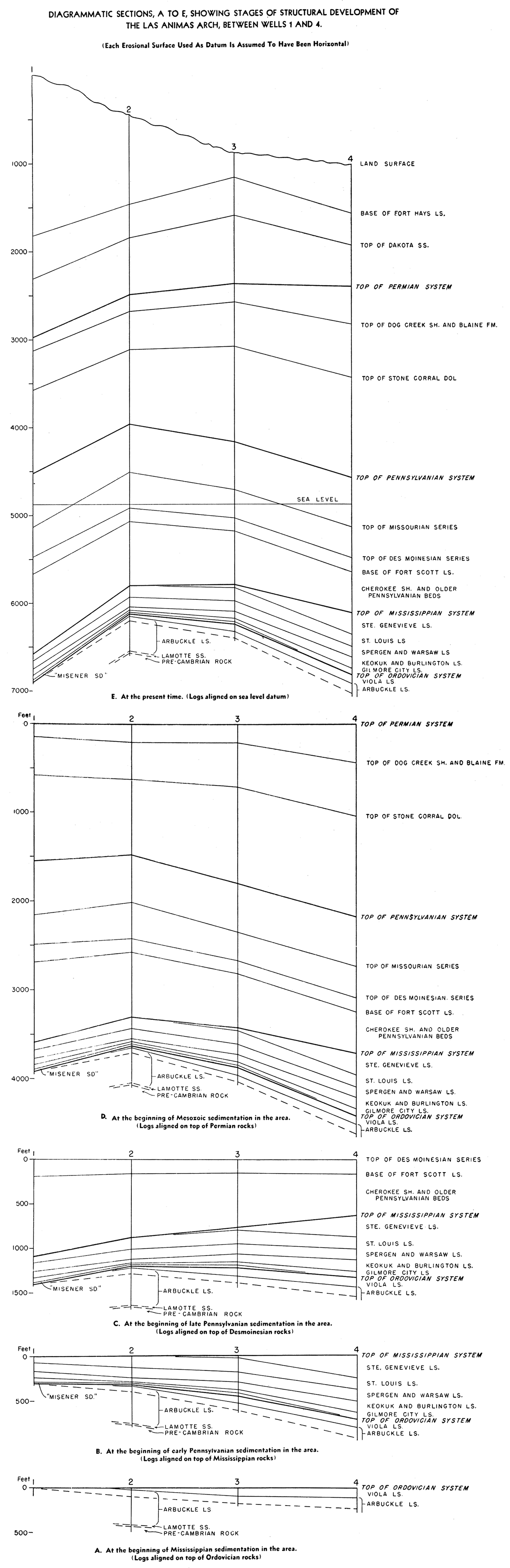
Diagram A represents the structural attitude of the Ordovician beds at the beginning of Mississippian deposition in the area. The eastward dip and eastward increase in thickness of the Viola and Arbuckle limestones was rather uniform across the area. The Viola limestone overlies successively older beds in the Arbuckle westward and pinches out between wells 1 and 2. The westward thinning of these Ordovician beds may be due in part to nondeposition and in part to regional erosion in post-Viola time.
The conditions shown on diagram B suggest (1) that the region of the arch subsided rather uniformly during Mississippian time, but (2) that the Mississippian beds which extended across the arch were later tilted toward the east and truncated by post-Mississippian erosion. The data from these four wells show that at the end of this post-Mississippian erosion the rocks formed a monocline dipping eastward at a low angle. Thereafter regional downwarping affected the western part of the area and thus created the earliest suggestion of anticlinal structure. Subsidence that formed a large basin including the western part of the area seems to have progressed during lower and middle Pennsylvanian time, for the thickness of a sequence of black shale and limestone of pre-Cherokee age and the thickness of the overlying beds of Desmoinesian age increase westward from well 4 to well 1. Diagram C shows that the arch was clearly defined by the end of Desmoinesian time, when the structural relief on the top of the Ordovician beds was about 200 feet.
The arch seems to have been accentuated by minor structural adjustments throughout late Pennsylvanian and Permian time. Prior to deposition of Mesozoic sediments over the Permian rocks (diagram D), the region had been tilted eastward and the younger Permian beds had been truncated; the Day Creek dolomite and possibly the Whitehorse sandstone had been removed from the area including wells 1 and 2. Finally, diagram E, which shows the present structural attitude of the Cretaceous and older rocks, indicates that considerable movement has occurred since the beginning of Mesozoic sedimentation, for the structural relief on the top of the Ordovician beds between the four wells is now about 750 feet.
Although the Central Kansas uplift and the Las Animas arch are the only major structural features in the area of this cross section, several smaller structural features are present and they may be important factors in the accumulation of oil and gas. The eastward regional dip of the beds between the Las Animas arch and the Central Kansas uplift is interrupted in T. 19 S., R. 31 W., Kansas, where the data suggest that considerable upwarping took place during Ordovician time and again at or following the close of Mississippian time and again following Pennsylvanian time. This structural feature lies at the eastern margin of a westward thickening wedge of Cherokee and pre-Cherokee Pennsylvanian beds. Three local structural features that have been proved to be economically important are present in T. 18 S., R. 25 W.; T. 20 S., R. 33 W.; and T. 21 S., R. 34 W., Kansas, near the line of the section. The Aldrich, Shallow Water, and Nunn oil pools are on these structures.
Oil and gas reservoir beds in the fields of western Kansas include the Lamotte sandstone, Arbuckle limestone, Simpson rocks, Viola limestone, Mississippian limestone, the "Patterson sand" of the Cherokee shale, the Sooy conglomerate, limestone beds of the Lansing and Kansas City groups, limestone beds at the top of the Shawnee group, and several limestone and dolomite beds in the Chase -and Sumner groups. Important unconformities are associated with each of these groups and formations except, perhaps, the "Patterson sand" and the limestone and dolomite beds in the Chase and Sumner groups. Oil pools along the course of this section are (1) the Aldrich pool in T. 18 S., R. 25 W., Ness County, Kansas, which yields oil from limestone beds in the Mississippian system, possibly in the basal part of the St. Louis limestone or in the upper part of the Spergen limestone; (2) the Shallow Water pool in T. 20 S., R. 33 W., Scott County, Kansas, which yields oil from beds lying near the top of the St. Louis limestone; (3) the Nunn pool in T. 21 S., R. 34 W., Finney County, Kansas, which yields oil from both a bed of sandstone in the Pennsylvanian and a bed of limestone in the Mississippian system; (4) the Patterson pool in T. 22 S., R. 38 W., Kearny County, Kansas, which yields oil from the "Patterson sand," which may be the basal bed of the Cherokee shale. In each of the first three pools listed above, as in most Kansas oil fields, the trap that caused the accumulation of the oil in the pool seems to be a combination of anticlinal and stratigraphic types. In each place the trap seems to have been formed by the truncation of an anticline and the subsequent sealing of the permeable beds by the deposition of younger relatively impermeable strata. The oil-bearing bed in the Patterson pool seems to be a lenticular body of sand within a thick, essentially impermeable shale unit; it is therefore truly a stratigraphic trap. Conditions favorable to the accumulation of oil and gas at places along the course of this section are suggested (1) by the structure and stratigraphy between wells 10 and 11 in Ness County, Kansas, where the wedging out of the Simpson beds is particularly noteworthy; (2) between wells 7 and 9 in eastern Scott County, Kansas, where a large anticline is present in the Mississippian and Ordovician rocks and the pre-Cherokee Pennsylvanian beds wedge out on the western flank of the anticline; (3) between or adjacent to wells 2 and 3 on the Las Animas arch in Kiowa County, Colorado, where both anticlinal and stratigraphic traps may be present. The reservoir beds for most of the known oil pools of western Kansas are in limestone formations that persist westward from the oil pools into eastern Colorado; in addition, the possible presence of sand bodies that were deposited as bars along old shore lines or as channel fillings enhances the prospects of the region. The "Misener sand" is present in several wells of the section; beds of sand of Simpson age may be expected in a large area south of the line of the section; and the thin beds of sand that are present in the Cherokee and pre-Cherokee beds of the Pennsylvanian offer some hope that thicker sands may be present in these formations in parts of the area.
Koester, E. A., 1935, The geology of the Central Kansas uplift: Am. Assoc. Petroleum Geologists Bull., vol. 19. no. 10. p. 1405.
Lee, Wallace, 1943, The stratigraphy and structural development of the Forest City basin in Kansas: Kansas Geol. Survey, Bull. 51, 142 p. [available online]
Kansas Geological Survey
Placed on web Sept. 28, 2018; originally published in 1946.
Comments to webadmin@kgs.ku.edu
The URL for this page is http://www.kgs.ku.edu/Publications/Bulletins/OGI2/index.html