Kansas Geological Survey, OGI 13
Originally published in 1955 as Kansas Geological Survey Oil and Gas Investigations 13. This is, in general, the original text as published. The information has not been updated. An Acrobat PDF version (15 MB) is also available.
The Cambridge arch is probably the least known major structural feature in Kansas, mainly because of the lack of subsurface information available in the western and northwestern parts of the State. However, in recent years additional drilling for oil has greatly increased the available information necessary for interpretation of the geologic history and structural development of western Kansas. New oil field discoveries have been particularly encouraging and emphasize the immense potential possibilities of this area. Exploration and exploratory drilling have been conducted at a particularly rapid pace in the vicinity of the Cambridge arch especially since the discovery of the Norton oil field in May 1953.
The Cambridge arch is a large anticline, having a northwest-southeast trend, located in south-central Nebraska and northwestern Kansas (Fig. 2). Most of the structure occurs in Nebraska; however, the southern end extends into Kansas mainly in Decatur and Norton Counties. The arch lies on the same major axis as the Chautauqua arch and Central Kansas uplift of Kansas, the Chadron arch of Nebraska, and possibly the Black Hills uplift of South Dakota. All these structures, although not of the same age, lie on a broad arcuate anticlinal trend which is convex. to the southwest. The structural history of the Cambridge arch and the immediately surrounding area in Kansas is depicted by a series of structural maps, isopachous maps, and cross sections.
The information used in the construction of these maps was obtained from many sources. A large part of the data came from the interpretation of electric logs supported by examination of well samples. Logs of the Kansas Sample Log Service were also used extensively. Some gamma ray logs were used. In areas where other logs were not available, information was obtained from drillers logs and scout tops. Reports by Ver Wiebe (1941, 1942, 1943, 1944, 1945, 1946, 1947) on exploration for oil and gas in western Kansas were useful in obtaining information on ground elevations and reported formation tops. In many places this is the only source of information on wells drilled previous to 1947.
Maps prepared show the structure on (1) the top of the Arbuckle group of Cambro-Ordovician age, (2) the top of the Lansing group of Pennsylvanian age, (3) the, top of the Stone Corral formation of Permian age, (4) the top of the Dakota formation of Cretaceous age, and (5) the base of the Fort Hays limestone member of the Niobrara formation (the top of the Carlile shale) of Cretaceous age. The structure map on the top of the Dakota formation was omitted because of its close similarity to the structure map on the base of the Fort Hays limestone. Isopachous maps were prepared between the intervals of (1) the top of the Arbuckle group and the top of the Lansing group, (2) the top of the Lansing group and the top of the Stone Corral formation, (3) the top of the Stone Corral formation and the top of the Dakota formation, and (4) the top of the Dakota formation and the base of the Fort Hays limestone member of the Niobrara formation. The pre-Pennsylvanian areal geology is shown and several cross sections are presented.
The contour interval differs with the individual map and depends upon the structural magnitude of the datum horizon or the amount of structural development which occurred during the particular stratigraphic interval. Intervals of 20, 25, 50, and 100 feet were used. The maps contain information that was available to the State Geological Survey on December 15, 1954.
Although a considerable amount of information is available in parts of the described area and it is shown in some detail, over much of the area the wells are scattered and information is limited. These places are shown by broken contour lines. The actual control for contouring is shown by representative well symbols. It is recognized that each new well drilled will necessitate some adjustment of the contours; however, it is felt that the regional picture will not change appreciably and that the maps are of a quality sufficient to support the forthcoming conclusions.
A regional structural map on top of the Dakota formation in western Kansas and adjoining areas was published by Darton in 1905. This map was later revised in 1918 (Darton, 1918). In 1926, Bass published a map of western Kansas showing the structure on top of the Dakota formation. These maps were constructed on a small scale and were intended to show only the regional structure. Structure on a county basis is discussed in many individual reports for western Kansas counties, especially those by Rubey and Bass (1925), Wing (1930), Landes (1930), Elias (1931), and Smith (1940), Work on the structure and structural development in adjoining areas has been done by Collins (1947), Fuenning (1942), Lee (1953), Lee, Leatherock, and Botinelly (1948), McCoy (1953), Maher (1946, 1947, 1948, 1953a, 1953b), Maher and Collins (1949), Reed (unpublished maps, Nebraska Geol. Survey), and Van Tuyl, Parker, and Fenwick (1938). Jewett in 1951 prepared a lexicon of named geologic structures in Kansas.
Lee and Merriam (1954a) published detailed regional maps of western Kansas showing the structure and structural development of the upper Permian and Cretaceous. These regional maps were prepared on the tops of the Stone Corral formation, Dakota formation, Carlile formation, and Niobrara formation. The Tertiary structural history of western Kansas was presented in a paper by Merriam and Frye (1954). It was this preliminary work that suggested the magnitude and configuration of the Cambridge arch in Kansas and led to the preparation of this report. Most recently in a report by Merriam and Goebel (1954) the configuration on the Pre-Cambrian surface is shown for Norton County, Kansas. This includes most of the Pre-Cambrian surface of the Cambridge arch that is present in Kansas.
Rocks in the area of the Cambridge arch range in age from Pre-Cambrian to Quaternary. However, this report is not concerned with detailed stratigraphy so it is only briefly treated here. The reader is referred to Moore and others (1951) for a more complete description of the geologic column.
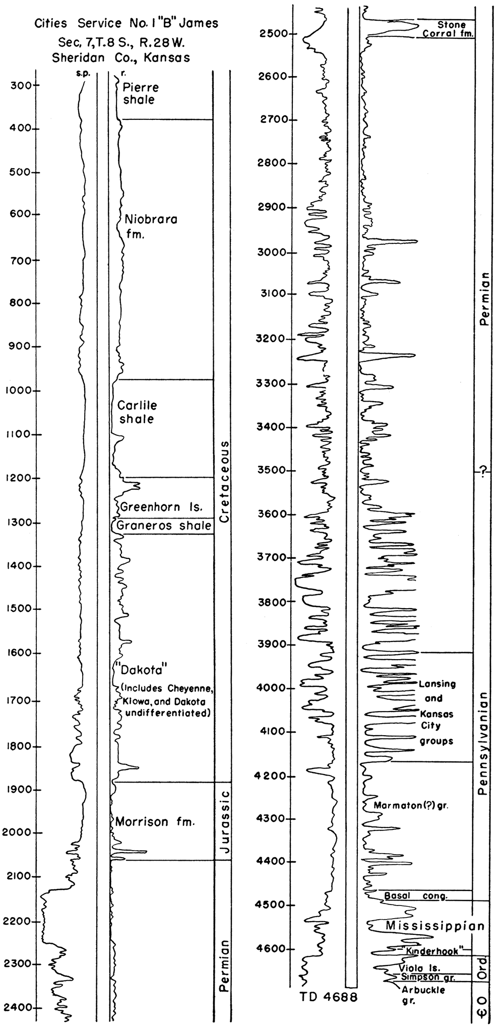
The stratigraphy is summarized in Figure 1 which shows the relative position of the datum horizons in the section by an electric log of the Cities Service No. 1 "B" James well, sec. 7, T. 8 S., R. 28 W., Sheridan County. This log was used because it represents the most complete section in the area. Rocks of the Silurian, Devonian, and Triassic Systems are not present.
Figure 1—Electric log showing relative stratigraphic position of rock units mentioned in this report.
Pre-Cambrian rocks were encountered in very few wells except those on the crest of the arch where the cover is relatively thin. Away from the arch toward the deeper parts of the flanking basins, this meager control rapidly diminishes. The configuration of the contours in Norton County shows that the Pre-Cambrian surface plunges southeastward and slopes both northeastward and southwestward. In southeastern Norton County the plunge reverses to form a low broad saddle that separates the Cambridge arch proper from the area of the Central Kansas uplift (Merriam and Goebel, 1954, fig. 3).
The Pre-Cambrian is reported as granite, schist, gneiss, and quartzite. The granite is composed of quartz, pink feldspar, and biotite mica and thus could be considered a biotite-bearing granite. A majority of the wells which penetrate the Pre-Cambrian encounter this rock type on the Cambridge arch. Chloritic and micaceous schist were reported from some wells in the southeastern part of T. 3 S., R. 24 W. In southwestern Phillips County one well reported quartzite and one well in northwestern Rooks County reported gneiss. The fresh-appearing granite or schist is usually overlain by a weathered arkosic zone of reworked Pre-Cambrian material, referred to as "granite wash."
The distribution of the different rock types gives a vague suggestion that the biotite-bearing granite was intruded into older pre-existing sediments, for, in general, the area of the granite is surrounded by meta-sediments—e.g., quartzite, schist, and gneiss. The schist which occurs on the crest of the arch could be interpreted as a roof pendant. Detailed petrographic work and regional consideration of the Pre-Cambrian would help clarify these problems.
The Reagan sandstone (Lamotte sandstone) unconformably overlies the Pre-Cambrian where it probably accumulated as a sheet deposit. However, because of the limited number of wells that have penetrated the Reagan this is only an assumption. Locally the formation is missing where it has been removed by post-Reagan erosion. The sandstone is composed of white to gray, medium- to coarse-grained, angular to subrounded, frosted quartz grains. In places the formation is dolomitic and may contain traces of glauconite.
The Arbuckle group, which is not subdivided in this report, consists mostly of gray to buff, dense or porous and vuggy, medium to coarse crystalline limestone and dolomite. Some of the rocks contain a light-gray, subopaque chert or an oolitic chert. Many of the beds are glauconitic. Where the Reagan sandstone is absent the Arbuckle lies directly on the Pre-Cambrian surface.
It is probable that most of the rocks reported as Arbuckle in western Kansas are or are equivalent to the Bonneterre dolomite, although the Bonneterre is not recognized as part of the Arbuckle group. If this is the case, then these rocks are Late Cambrian in age and properly should not be considered under the heading of Cambro-Ordovician. This is also the opinion expressed by Maher and Collins (1949, sheet 1). In a well drilled in Rawlins County (sec. 21, T. 3 S., R. 32 W.), R. A. Carmody states in a note on a log of the Kansas Sample Log Service that the Arbuckle was topped at 4,694 feet and the Bonneterre or equivalent at 4,800 feet. The rocks above the Bonneterre he believes are pre-Roubidoux and probably Late Cambrian in age. However it is not clear to what formation these rocks should be assigned in the classification, but presumably they belong to the Eminence dolomite, as the Eminence is recognized in western Kansas (Moore and others, 1951, p. 122).
Where the Arbuckle was exposed to erosion on and along the flanks of uparched areas such as the Cambridge arch, the dolomites and limestones were deeply weathered. It is in this weathered zone, where good porosity and permeability were developed, that petroleum reservoirs occur.
The Simpson formation unconformably overlies the Arbuckle and is a white to gray, fine- to coarse-grained, angular to subrounded, dolomitic sandstone. The formation also contains some coarse crystalline sandy dolomite.
The Viola limestone is a gray, buff, or tan, fine to medium crystalline dolomite with white, smooth subopaque chert. The Viola unconformably overlies the Simpson formation.
Rocks classified as the Kinderhookian, Osagian, and Meramecian Series are represented in the Cambridge arch area. The areal distribution of the different formations of the Mississippian System in western Kansas is shown by Clair (1948), Lee (1940) gives a complete description of the Mississippian rocks in Kansas.
The "Kinderhook" is a green to brown shale that is present locally and is placed in the Mississippian rather than the Devonian as a matter of convenience. It is possible that this shale is Chattanooga or Boice or equivalent. The Chattanooga shale is thin on the western side of the Central Kansas uplift and is known to be present farther souths Lee, 1953, p. 17). This shale unconformably overlies the Viola limestone.
Although the Mississippian is not subdivided in this report, several formations are recognized as being present. The most distinctive is the Gilmore City formation (Kinderhookian); Fern Glen, Keokuk-Burlington (Osagian), and Warsaw (Meramecian) are also recognized. These rocks unconformably overlie the "Kinderhook" shale and consist of white, dense, cherty, or oolitic limestone. Present at the top of the Mississippian sequence is a residual chert sometimes as much as 50 feet thick which may be very latest Mississippian or very earliest Pennsylvanian in age. The chert is white, smooth, and opaque to subopaque. This chert overlies progressively older beds to the northeast and overlies beds as old as Arbuckle on the southwestern flank of the Cambridge arch. This same sort of situation on a smaller scale occurs on the east side of the Central Kansas uplift where according to Lee (personal communication) the chert is present, but seemingly developed to a lesser extent.
No attempt was made to differentiate the groups or formations of the Pennsylvanian System in this report except to recognize the top of the Lansing group and the base of the Kansas City group. The lowest beds of Pennsylvanian age in the vicinity of the Cambridge arch probably are correlative with the "Cherokee" and Marmaton groups. The stratigraphic relations of these lower groups are complicated by the presence of the Cambridge arch which seemingly was a topographic high during their deposition. The basal Pennsylvanian conglomerate is present over a considerable area, but its extent and thickness have not been thoroughly investigated. The conglomerate unconformably overlies the Mississippian where it is present and consists in some places of red, gray, or varicolored sandy shale. The areal extent of the conglomerate and the "Gorham" sandstone, which is a finer grained equivalent, was found by Merriam and Goebel (1954, p. 142) to be limited in the Norton oil field.
The beds of the Pennsylvanian consist mainly of marine limestone alternating with shale and thin beds of sandstone. Some of the limestones are cherty and others are oolitic. Several black shales, such as the Heebner shale member of the Oread limestone formation, serve as excellent marker horizons in the Pennsylvanian, especially on electric logs. The base of the Kansas City group is also easily recognized on electric logs and thus is often used as a datum plane for structural mapping. However, it is quite probable that the base of the Kansas City sequence in this area does not correspond to the base of the group as recognized in eastern Kansas (Lee, personal communication). The stratigraphic intervals in the Pennsylvanian above the base of the Kansas City remain fairly constant.
The Pennsylvanian unconformably overlies all older beds; on the crest of the Cambridge arch it overlies Pre-Cambrian rocks.
The lower part of the Permian section consists mainly of limestone and dolomite alternating with shale and some sandstone. The upper part of the section is composed of redbeds, sand, and shale, with thin beds of anhydrite, gypsum, and salt. One of the anhydrites, the Stone Corral formation, is one of the best marker beds in the section. The Stone Corral is a white, finely crystalline anhydrite with a sugary texture. Locally the formation is dolomitic especially near the base. The Permian dis conformably overlies the Pennsylvanian.
The pre-Mesozoic areal geology is shown by Merriam (1955). The distribution and relative positions of the different formations of the Permian essentially outline the shape of the Hugoton embayment. The pattern shows that the strike of the formations parallels the trend of the Central Kansas uplift and the Cambridge arch in a northwest-southeast direction along the western side of the two structural highs. The thickness of the beds increases toward the axis of the embayment which plunges southward. The Permian surface was beveled extensively before the deposition of Mesozoic rocks.
The Morrison formation of Jurassic age is composed of greenish-gray, sandy shale with minor amounts of limestone, chert, and anhydrite. The limestone is white to cream, slightly crystalline to chalky, soft to hard, and pyritic. The chert is translucent with a pink tinge. The anhydrite is white to pink and crystalline. The Morrison formation forms an overlapping relationship on the pre-Jurassic surface and unconformably overlies older strata (Merriam, 1955, p. 34).
The Comanchean Series is represented by the Cheyenne sandstone and the Kiowa shale. These formations were not differentiated from the upper Cretaceous Dakota formation.
The Gulfian Series consists of the Dakota formation, Graneros shale, Greenhorn limestone, Carlile shale, Niobrara formation, and Pierre shale. The Dakota formation consists of clay with small amounts of siltstone and sandstone; however, in well samples usually only the coarser sediments remain along with the characteristic siderite pellets, the clay being carried away by drilling mud. The Graneros is a uniformly thick, gray, fissile, silty, and pyritic shale. The Greenhorn is a chalky limestone and shale with the Fencepost limestone bed at the top of the formation. This limestone causes a characteristic peak which can be recognized on electric logs also in Nebraska, Colorado, and Wyoming. The Carlile is divided into two members: the upper member, the Blue Hill shale, is gray, noncalcareous, micaceous, and pyritic; the lower member, the Fairport chalky shale, is gray mottled and calcareous with thin stringers of limestone. The formation is capped by the Codell sandstone unit. The Niobrara formation is divided into the Fort Hays limestone (lower) and the Smoky Hill chalk (upper) members. The Fort Hays is a white to light-gray chalky limestone; the Smoky Hill is composed of soft chalky limestone and chalky shale. The Pierre shale is light- to medium-gray, soft, micaceous, and calcareous. The upper Cretaceous formations are conformable to each other but the Cretaceous as a whole unconformably overlies older beds.
The Tertiary System is represented by the Ogallala formation (of Pliocene age) which is composed mainly of unconsolidated sand, gravel, and silt. The formation is capped by the "Algal limestone." The Ogallala unconformably overlies Cretaceous, Triassic, and Permian rocks.
The Quaternary System consists of unconsolidated sand, gravel, and silt, which unconformably overlie older beds.
The Cambridge arch is one of several major structural features situated on a broad arcuate anticlinal axis extending across the mid-continent region in a northwest-southeast direction from the Ozark dome of Missouri to the Black Hills uplift of South Dakota. Each of the features on this axis—Chautauqua arch, Central Kansas uplift, Cambridge arch, Chadron arch, and Black Hills uplift—are separate entities. In general, the Black Hills had later movement than the Chadron arch, the Chadron arch had later movement than the Cambridge arch, etc., so that the structures on the northwestern part of the trend show later movement than those to the southeast. The relation of the Cambridge arch to other major structural features in Kansas is shown in Figure 2.
Figure 2—Index map showing area covered in this report in relation to post-Mississippian structural provinces in Kansas (modified from Lee and Merriam, 1954a, fig. 2; and Jewett, 1951, fig. 2).
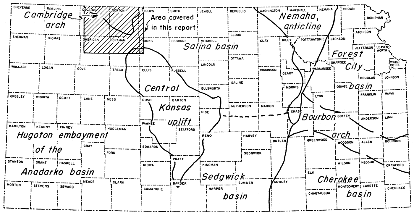
The Cambridge arch and the Central Kansas uplift separate the Hugoton embayment on the west from the Salina and Sedgwick basins on the east. The Nemaha anticline strikes at almost right angles to the Cambridge arch-Central Kansas uplift-Chautauqua arch trend and cuts across the trend in southern Butler County and Cowley County (Lee and Merriam, 1954b). The Nemaha anticline separates the Salina and Sedgwick basins on the west from the Forest City and Cherokee basins on the east. The indistinct low Bourbon arch separates the Forest City basin from the Cherokee basin. The Chautauqua arch does not show on Figure 2 since its main structural development was pre-Mississippian.
Structural contour maps were prepared on four different datum horizons: (1) the top of the Arbuckle group of Cambro-Ordovician age, (2) the top of the Lansing group of Pennsylvanian age, (3) the top of the Stone Corral formation of Permian age, and (4) the base of the Fort Hays limestone member of the Niobrara formation of Cretaceous age. Although the maps were prepared in some detail, they are intended to show only the regional structure.
Information from many sources was utilized in the preparation of the maps. In general, it was found that electric logs, sample logs, and logs of the Kansas Sample Log Service were the best sources of data. Drillers logs and scout tops were also used where information from other sources could not be obtained and were found to be fairly reliable. The well symbols on each map show the source of information for the datum so that the reliability of each can be judged. Each new well drilled probably will modify the contours slightly; however, it is believed that the maps show the regional structure with considerable accuracy.
This report contains the first use of the names of three structures by the State Geological Survey. These are the Jennings anticline, Selden syncline, and Long Island syncline. The concept of the Cambridge arch as shown by Bass (1926, p. 85) and reproduced by Jewett (1951, fig. 2) has been modified by additional information. The name for the arch comes from the town of Cambridge, Furnas County, Nebraska.
The Jennings anticline is defined as a north-south trending southerly plunging structure located in Ts. 3, 4, 5, and 6 S., Rs. 26 and 27 W., in eastern Decatur and northeastern Sheridan Counties, Kansas. The structure is named for the town of Jennings in southeastern Decatur County which is located on the crest of the anticline. The northwesterly plunging Selden syncline is located in southeastern Decatur and northeastern Sheridan Counties and is named for the town of Selden, Sheridan County, Kansas. The Long Island syncline is a broad northeasterly plunging syncline located in eastern Norton and northwestern Phillips Counties, Kansas. The structure is named for the town of Long Island in Phillips County which is near the axis of the syncline.
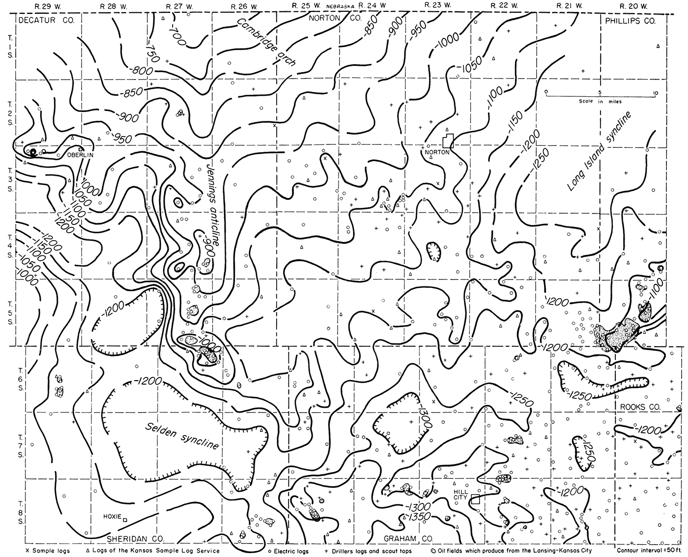
The structure on top of the Arbuckle group is shown in Figure 3. The areas from which the Arbuckle was removed by post-Arbuckle erosion are shown as well as the oil fields which-produce from the Arbuckle. The control on this map is scanty as only a few of the wells have been drilled as deep as the Arbuckle except in areas near the Central Kansas uplift or the Cambridge arch. There are numerous townships where no wells have reached the top of the Arbuckle, especially in the southwestern part of the area where the drilling depth to it is as much as 4,800 feet.
Figure 3—Map showing by 100-foot contours the structure on the top of the Arbuckle group and position of the oil fields that produce from the Arbuckle. The map reveals several major structural features such as the Cambridge arch, Jennings anticline, Long Island syncline, and Selden syncline as well as the area from which the Arbuckle is absent.
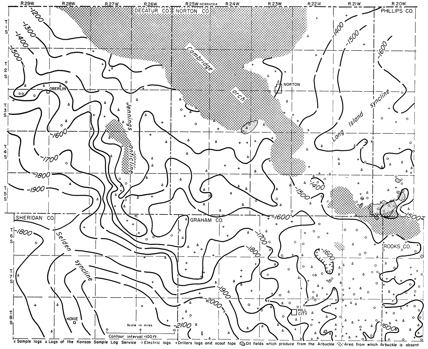
Several major structural features are revealed by the map. An anticlinal axis extends in a northwest-southeast direction from southeastern Norton and northwestern Rooks Counties to central Norton County where control ceases because of the absence of the Arbuckle rocks. This anticline is relatively broad, 8 to 10 miles wide, but flares out wider to the northwest and the southeast. The feature has a structural relief of about 100 feet with minor local closures on the crest. Local structural noses and re-entrants are located on both flanks of the anticline. A minor synclinal closure is located in Ts. 6 and 7 S., R. 22 W. Other areas of closure probably would be revealed if the map were contoured on a smaller contour interval. The southwestern end of the Stuttgart-Huffstutter anticline in southwestern Phillips County is also revealed as being on this low uparched area. The Stuttgart-Huffstutter anticline has a northeast-southwest trend.
The Long Island syncline, which flanks the Cambridge arch on the northeast, is located in western Phillips and northeastern Norton Counties, whereas the Selden syncline, which flanks the arch on the southwest, is located in Sheridan and southwestern Decatur Counties. A low saddle in T. 6 S., R. 28 W. divides the Selden syncline so that north of the saddle the beds dip northwestward and south of the saddle the beds dip southeastward. The long, narrow, north-south trending Jennings anticline is located in southeastern Decatur County in Ts. 3, 4, 5, and 6 S., Rs. 27 and 28 W. This anticline has almost 100 feet of closure locally.
The shape and position of the contours seem to indicate that the Arbuckle once covered all the area and was subsequently removed by post-Arbuckle erosion. The strike of the contours on top of the Arbuckle in northern Decatur and northeastern Norton Counties roughly parallels the area from which the Arbuckle is absent or in other words corresponds to the crest of the Cambridge arch. Farther south in southern Norton County, the contours abut into the area from which the Arbuckle is absent. If the Arbuckle were present on the crest of the arch, the contours probably would connect across the area, forming southerly convex arcs showing the beds dipping southeastward. Furthermore there is nothing to indicate from the clastic content of the group that the area of the Cambridge arch was topographically high during Arbuckle time, furnishing sediments or in any way acting as a source area. Thus, it can be concluded only that the Arbuckle was deposited over the entire area and subsequently removed on the crest of the arch by erosion. Two other areas, from which the Arbuckle is absent, are also located on structural highs: an area in southeastern Decatur County and one in southeastern Norton County, southwestern Phillips County, and northwestern Rooks County.
Since the top of the Arbuckle represents an erosional surface, it must be remembered in contouring that some irregularities of this old topographic surface will be reflected in the contours unless the contour interval is large enough (for example 100 feet) to minimize the topography. The topographic relief is believed to be smaller in magnitude than the structural relief.
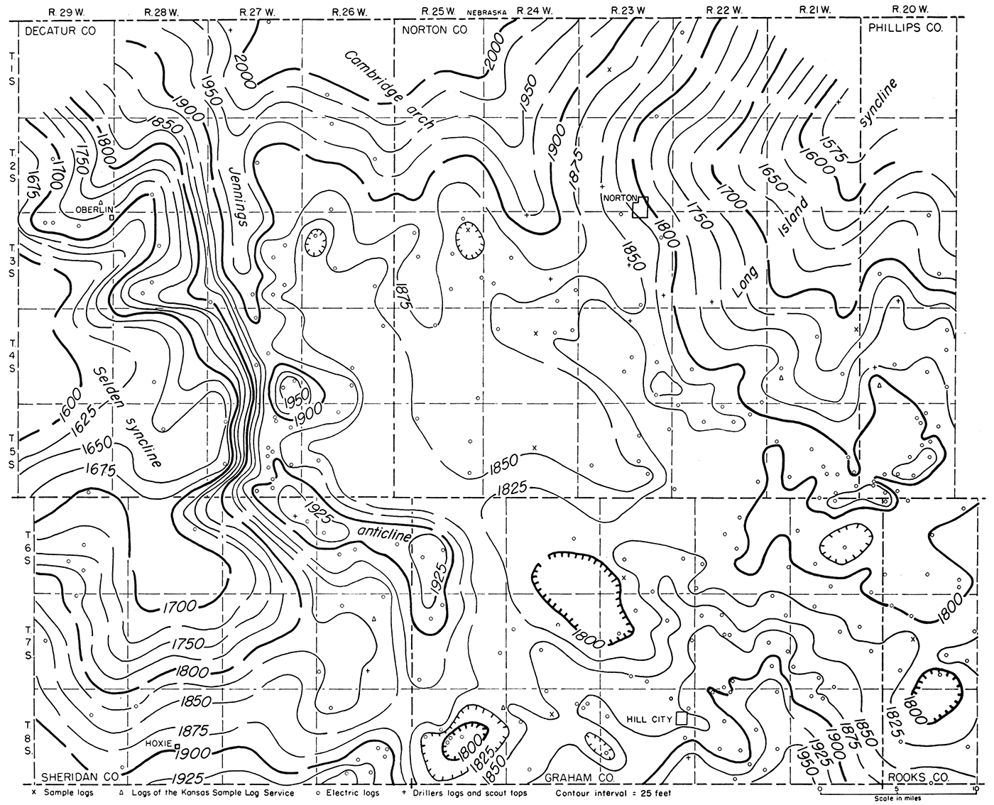
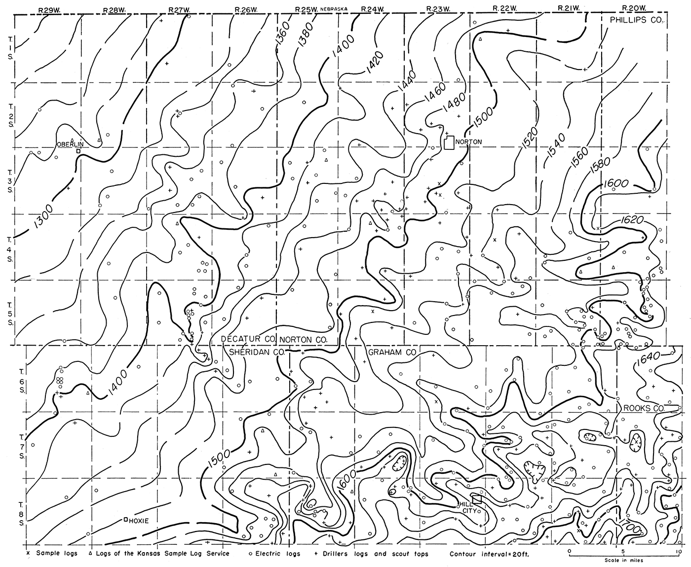
The structure on top of the Lansing group is shown in Figure 4. The control on this map is especially good since the top of the Lansing, commonly used as a datum horizon for structural mapping in Kansas, is reported for most wells. This is because a majority of the wells are either tests of or produce from the Lansing-Kansas City zone. Oil fields which produce from the Lansing are shown on the map.
Figure 4—Map showing by 50-foot contours the structure on the top of the Lansing group. The Cambridge arch, Jennings anticline, Long Island syncline, and Selden syncline are revealed, Positions of the oil fields that produce from the Lansing and other Pennsylvanian zones are also shown.
Several major structural features are revealed on the Lansing structural map, including the Cambridge arch, Long Island syncline, Selden syncline, and Jennings anticline. These are the same structures seen on the Arbuckle map (Fig. 3). Other minor structural anticlines and synclines are also shown.
The Cambridge arch is reflected by the contours in northwestern Norton and northeastern Decatur Counties. The contours show that the Lansing dips more or less regularly about 25 feet per mile on the flanks of the arch. Several minor structural noses and re-entrants which plunge southeastward occur on the southeast margin of the arch. Some of these features would show closure if a smaller contour interval were used. As surmised from the Arbuckle map, the contours swing around the southeastern end of the arch convexed southeastward. The arch is separated from the Central Kansas uplift by a series of small closed synclinal basins located along a large structurally flat area in northern Graham County. The Cambridge arch is flanked on the east and northeast by the Long Island syncline and on the west and southwest by the Selden syncline.
The Long Island syncline which has a northeast-southwest trend and a northeast plunge is located in eastern Norton County and western Phillips County. There is little control in the center and on the northwest flank of the basin.
The Selden syncline is a northwest-southeast trending structure located in northeastern Sheridan County and southeastern Decatur County. The structure has several closed lows located along the axis but, in general, plunges northwestward. A small structural saddle in T. 6 S., R. 28 W. separates two of these closed areas. Another saddle is located in T. 5 S., R. 28 W.
The southwestern end of the Stuttgart-Huffstutter anticlinal trend is located in the southwestern part of Phillips County. This prominent trend extends in a northeast-southwest direction across western Phillips County (Lee and Merriam, 1954a, p. 1). Locally along this trend there is as much as 150 feet of closure.
The Jennings anticline is located in Ts. 3, 4, 5, and 6 S., Rs. 26 and 27 W. This anticline trends north-south and plunges southward in Decatur County but in northern Sheridan County the trend swings to a southeast direction. There are several local areas of closure along the crest of the anticline. The dip on the west side of the structure is steeper than on the east. This feature outlines the western margin of the Cambridge arch.
The structure on top of the Stone Corral formation is shown in Figure 5. Because of the contrast of the Stone Corral formation (anhydrite) with the overlying and underlying beds (red shale and sandstone), it is a good reference marker in well samples and on electric logs. As it is persistent over most of the western part of the State it is often used as a datum horizon for structural mapping and as a reflecting horizon in seismic exploration.
Figure 5—Map showing by 25-foot contours the structure on the top of the Stone Corral formation. The same major structural features are present on this map that are revealed on the Arbuckle and Lansing structure maps.
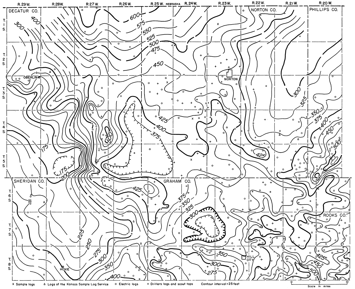
The structural map on the Stone Corral reveals the same major structures that are present on the structural map of the Lansing group (Fig. 4): the Cambridge arch, Long Island syncline, Selden syncline, and Jennings anticline. These structural features are shown also by Lee and Merriam (1954, pl. 1) in relation to the rest of western Kansas on a regional map contoured on top of the Stone Corral formation.
The Cambridge arch is reflected on the Stone Corral formation as a broad, southeasterly plunging anticlinal feature which has several smaller anticlines and synclines on the margins of the arch. These minor structural noses and re-entrants also plunge southeastward. A small closed anticline is located in T. 5 S., R. 22 W. The dip of the Stone Corral on the southwest side of the arch is steeper than on the northeast. The Cambridge arch is flanked on the southwest by the Selden syncline and on the northeast by the Long Island syncline. It is separated from the Central Kansas uplift by a broad synclinal area.
The southwestern end of the Stuttgart-Huffstutter anticlinal trend is located in southwestern Phillips County in Ts. 4 and 5 S., R. 20 W. The southeast flank of the anticline is steeper than the northwest flank and several small areas of closure are located along the crest of the trend. It is separated from the Cambridge arch by the northeast-southwest trending northeast-plunging Long Island syncline.
The western and southwestern flank of the Cambridge arch is bordered by the Jennings anticline in eastern Decatur and northeastern Sheridan Counties. This north-south trending structure plunges southward, but in northeastern Sheridan County the trend of the anticline changes to a northwest-southeast direction. The west and southwest flanks of the anticline are steeper than the east and northeast flanks. Several local closures are present along the crest of the structure. The Selden syncline is situated along the western edge of the Jennings anticline. This syncline trends in a northwest-southeast direction and plunges northwestward.
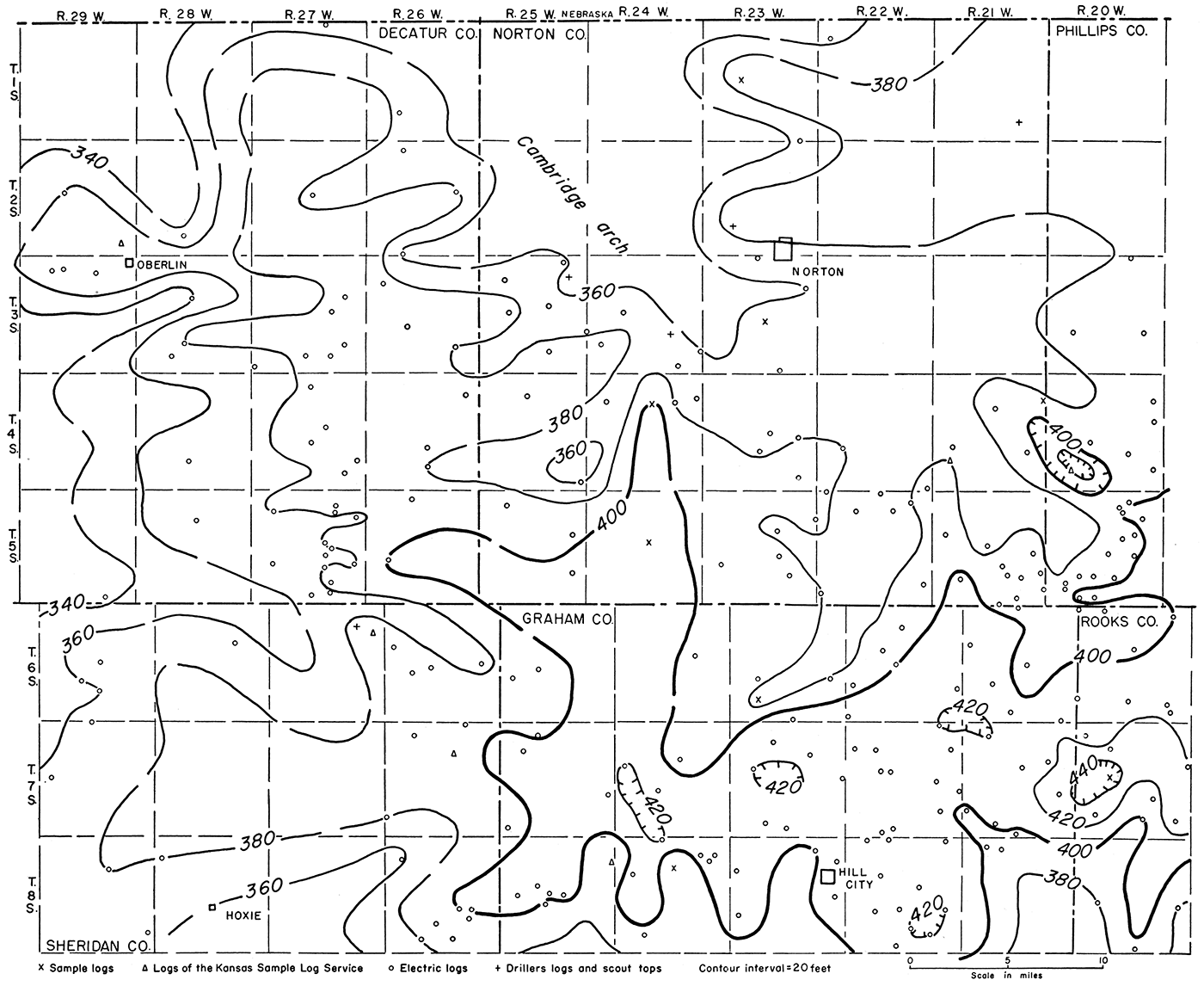
The structure on the base of the Fort Hays limestone is shown in Figure 6. The control on this map is scanty; however, enough control is available to show that the structure on the base of the Fort Hays agrees closely with that on the top of the Stone Corral formation.
Figure 6—Map showing by 25-foot contours the structure on the base of the Fort Hays limestone member of the Niobrara formation.
The same major structural features that were revealed on the Lansing and Stone Corral structural maps are revealed on the base of the Fort Hays: the Cambridge arch, Long Island syncline, Selden syncline, and Jennings anticline.
The contours show the Cambridge arch as a southeasterly plunging anticline with several minor structural noses and re-entrants located on the margins. On the west side of the arch the dip on the base of the Fort Hays is steeper than on the east side. The arch is flanked on the east and northeast by the northeasterly plunging Long Island syncline and on the west by the northwesterly plunging Selden syncline. The Cambridge arch is separated from the Central Kansas uplift by a structurally low flat area along which there are several closed synclines.
The southwestern end of the Stuttgart-Huffstutter anticlinal trend is recognizable in southwestern Phillips County although it is not as pronounced on the base of the Fort Hays as on the lower horizons. It is similar, however, as it has a northeast-southwest trend, steeper dips on the southeast flank, and several local closures.
The Jennings anticline trends north-south through eastern Decatur County and changes to a northwest-southeast trend in northeastern Sheridan County. The west side of the structure has steeper dips than the east. Several local areas of closure are located along the crest.
One of the primary concerns of the oil operator is whether or not the structure on the surface reflects the structure of the older beds at depth. If the surface structure does reflect the structure at depth then surface exploration is feasible. The relation of structure to depth is discussed for each of the major structures in the area: the Cambridge arch, the Long Island syncline, the Selden syncline, and the Jennings anticline.
Because the Arbuckle is absent on the crest of the Cambridge arch, the relation of the structure on this datum to those higher in the section is obscure. However, the area from which the Arbuckle has been removed corresponds to the crest of the arch on the Lansing structural map. By comparing the dips on the two horizons along the west flank of the arch, it is possible to determine that the structure on the Arbuckle is steeper than. on the Lansing. The structurally high area reflected on the Arbuckle in southeastern Norton County is also present on the Lansing, but is not as pronounced. A closed high on the Arbuckle in T. 5 S., R. 22 W. shows up as a southeasterly plunging nose on the Lansing.
The structural relief shown by the Stone Corral map is about the same magnitude as that shown by the Lansing map. Structural noses on the southeastern margin of the Cambridge arch as shown on the Stone Corral correspond approximately in position to structural noses on the Lansing. A small closed anticline in T. 5 S., R. 22 W. on the Stone Corral is reflected as a southeasterly plunging nose on the Lansing because the contour interval of the Stone Corral map is smaller (25 feet) than that of the Lansing map (50 feet).
The structural relief on the Fort Hays is, in general, less than that on the Stone Corral; otherwise the two maps are quite similar. The crest of the Cambridge arch seemingly is coincident on all the structural maps; however, it is hard to evaluate because the crest is so broad and flat.
The Long Island syncline shows up only vaguely on the Arbuckle, but is discernible as a northeast-southwest trending syncline plunging northeastward. The syncline also plunges northeastward on the Lansing, Stone Corral, and Fort Hays structural maps; however, the axis seemingly shifts north on the Lansing map. Other than this seeming shift of the axis, which may be the result of differential control on the maps, the syncline looks the same on the Stone Corral and Fort Hays structural maps. The magnitude of the structure is about the same on each of the datum horizons, but possibly decreases slightly in the younger beds.
The Selden syncline is divided into two parts by a low structural saddle in T. 6 S., R. 28 W. on the Arbuckle map. Control is sparse and it is not possible to determine if there is closure on either side of this saddle. In eastern Decatur County control is not sufficient to permit accurate delineation of the western limit of the syncline on the Arbuckle map.
The axis of the syncline, as shown on the Lansing, is slightly offset to the north of its position on the Arbuckle. The western limb of the syncline is better defined on the Lansing map and as a result the syncline seems to be narrower than on the Arbuckle map. The saddle in T. 6 S., R. 28 W. coincides on the two maps. There is another saddle on the Lansing in the northwestern corner of T. 5 S., R. 28 W. Both of these saddles are also present on the Stone Corral in approximately the same geographic position.
The structure on the Stone Corral is similar to the structure on the Lansing with the exception of northeastern Sheridan County where a large closed synclinal structure on the Lansing is open on the Stone Corral. The structural axis of the syncline is in approximately the same position on the Lansing, Stone Corral, and Fort Hays maps. In general, the amount of structural relief decreases toward the surface.
The Jennings anticlinal axis is in a corresponding position on both the Arbuckle and Lansing maps and the structural magnitude of the anticline is about the same. The Stone Corral and Fort Hays maps also show that the structural axis is located in approximately the same position. However, in Sheridan County the Fort Hays map indicates that the axis is west of the position of the axis on the Stone Corral. The small closed structural highs located along the crest of the anticline do not correspond on all the maps. This is undoubtedly due to the different contour intervals used. The structural magnitude, in general, decreases in the younger beds.
The structure as reflected by the surface beds of Cretaceous age should be a good indication of structure at depth with the exception of the Arbuckle in the area of the Cambridge arch. However, the magnitude of the structure at the surface will be considerably less than that at depth. The coincidence of surface and subsurface structure is not true farther east or south in the area of the Central Kansas uplift. Seemingly nowhere in western Kansas does the structure of the Tertiary rocks bear any relation to the structure of the older beds (Merriam and Frye, 1954, p. 61).
The structural development of the Cambridge arch and vicinity is depicted by a series of isopachous maps. Maps for the following stratigraphic intervals were prepared: (1) the top of the Arbuckle group to the top of the Lansing group, (2) the top of the Lansing group to the top of the Stone Corral formation, (3) the top of the Stone Corral formation to the top of the Dakota formation, and (4) the top of the Dakota formation to the base of the Fort Hays limestone member of the Niobrara formation. These intervals were used because they represent the structural development between the horizons used for the structural maps.
If both the surfaces were originally approximately horizontal and flat, the isopachous map shows in three dimensions the total amount of structural movement that affected the lower surface while the upper surface was still flat and undisturbed. If one of the surfaces was an erosional surface with considerable relief, the isopachous map will show the topography of that surface. These principles have been set forth and elaborated on by Lee (1954).
Since there are no beds of sufficient continuity present in the area between the Arbuckle and Lansing so that it would be possible to isopach a smaller interval, it was necessary to use the Arbuckle-Lansing thickness. This interval is a poor one to isopach for two reasons: (1) the interval is one of long time duration and most likely represents several conflicting structural movements which cannot be differentiated; therefore the early geologic history is obscure; and (2) the top of the Arbuckle is an erosional surface and Arbuckle rocks are absent over a large part of the area. The thickness map and pre-Pennsylvanian areal geology are presented in Figure 7.
Figure 7—Isopachous map showing by 50-foot isopachs the thickness of the interval from the top of the Arbuckle group to the top of the Lansing group. The pre-Pennsylvanian areal geology is shown as well as the lines of the cross sections (Figs. 8 and 9).
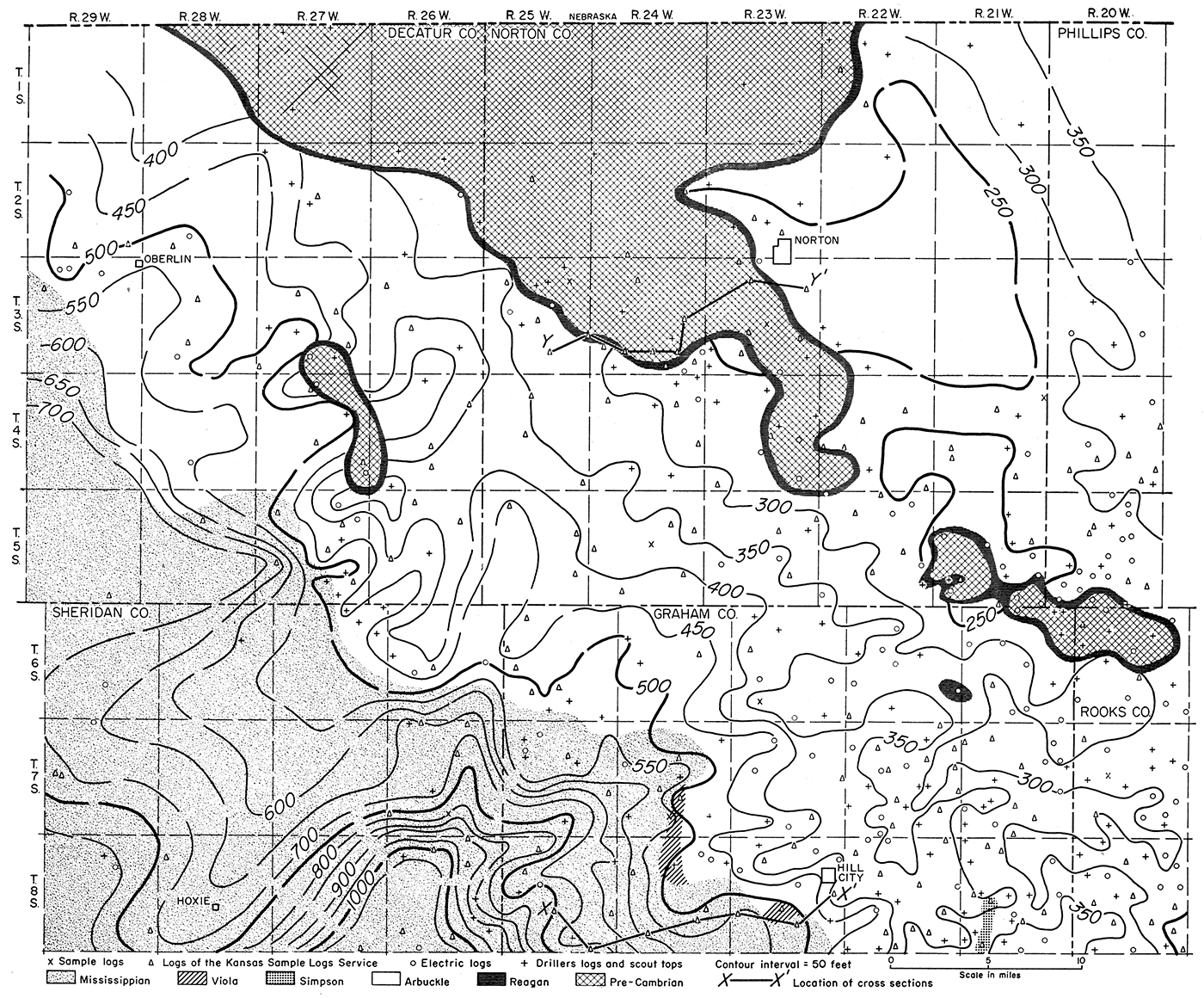
The pre-Pennsylvanian areal geologic map reveals the formations that are encountered immediately below the Pennsylvanian sediments. In northwestern Norton and northeastern Decatur Counties there is a large area from which the Arbuckle and younger beds were removed by post-Arbuckle erosion so that the Pennsylvanian lies directly on Pre-Cambrian rocks. This area corresponds to the crest of the Cambridge arch. The Reagan sandstone lies between the Pre-Cambrian and the Arbuckle, forming a narrow band rimming the arch. It is assumed that the Reagan was deposited in sheetlike form on the Pre-Cambrian surface rather than in local areas of low relief; thus it is shown as a continuous bed. Another area in which the Pre-Cambrian and Reagan are overlain by Pennsylvanian rocks occurs in the southeastern corner of Decatur County in Ts. 3 and 4 S., Rs. 26 and 27 W. This area corresponds to a position on the Jennings anticline. Another such area which has been eroded to the Pre-Cambrian is located in southeastern Norton, northeastern Graham, and northwestern Rooks Counties. This area corresponds to a structurally high feature on the northwestern end of the area of the Central Kansas uplift.
Mississippian rocks occur in the southwestern part of the area where they overlie older sediments toward the northeast. The Simpson formation and the Viola limestone occur below the Mississippian rocks and above the Arbuckle group. Because the Mississippian oversteps them, they do not show on the areal geologic map except in two small areas in Graham County in Ts. 7 and 8 S., R. 24 W. and T. 8 S., R. 23 W. At these places, the Viola limestone is not overlain by Mississippian rocks either because it was never covered or because it was covered and subsequently exposed. The Simpson, in turn, is overstepped by the Viola limestone and Mississippian rocks except in a small area in the southwestern part of T. 8 S., R. 21 W., in Graham County where it occurs as an erosional remnant on the Central Kansas uplift. There, the Simpson is reported from two wells. The Nadel and Gussman No. 1 Green (sec. 32, T. 8 S., R. 21 W.) had 4 feet of green sub waxy, sandy shale below the Pennsylvanian basal conglomerate and above the Arbuckle according to a log of the Kansas Sample Log Service. Another well, the Musgrove Petroleum Corporation No. 1 Brandt (sec. 20, T. 8 S., R. 21 W.) reported 31 feet of reworked Simpson-like sandy shale and dolomite occurring between the Pennsylvanian basal conglomerate and the Arbuckle.
The thickness map (Fig. 7) reveals a high area extending from northwestern Rooks County through eastern Norton County where it becomes obscure near the Cambridge arch where the Arbuckle was removed. The surface dips away in both directions from the crest of this irregular northwest-southeast trending high. The high is believed to result partially from structural movement and partially from topography but there is no way of telling the magnitude of either. It might be visualized as a broad northwest-southeast trending arch which formed a topographic divide. Both flanks of this structurally controlled topographic divide were deeply eroded. Control on the northeast flank of this high area is scanty. However, on the southwest side of the high area a series of southwesterly opened valleys is shown. These valleys seemingly simulate drainage patterns. A high divide, which dips to the southwest in southeastern Decatur and northeastern Sheridan Counties, separates two distinct valley systems. The valley system to the southeast of the divide has several minor tributaries emptying into a major valley in eastern Sheridan County which continues to the south and southwest out of the area. Another major system of valleys is located northwest of the divide where numerous minor valleys seem to coalesce in southwestern Decatur County.
As the early structural movements are obscure, a sequence of structural development cross sections (Fig. 8) was prepared along the line X-X' in an effort to evaluate these movements. Logs from the Kansas Sample Log Service were used in the preparation of this cross section, the location of which is shown on Figure 7. Three consecutive datum horizons were used to show the development along the line of the cross section. These are the top of the Mississippian (Fig. 8A), the base of a cherty limestone near the base of the Pennsylvanian (Fig. 8B), and the top of the Lansing (Fig. 8C).
Figure 8—Cross section along the line X-X' as shown on Figure 7. The wells shown in cross section are correlated on (A) top of the Mississippian, (B) base of a lower Pennsylvanian cherty limestone bed, and (C) top of the Lansing group.
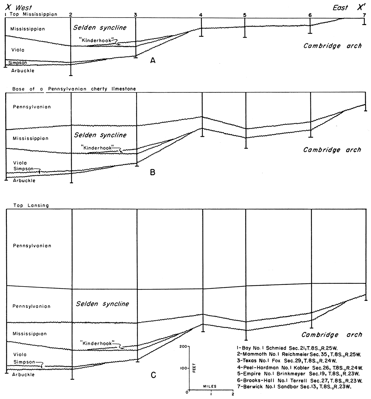
The first cross section (Fig. 8A) shows that the Cambridge arch and Selden syncline had already been formed at the end of Mississippian time. The profile also shows the pinch-outs of the beds eastward toward the Cambridge arch. Between wells 2 and 3 the Viola oversteps the Simpson and lies directly on the Arbuckle. This can be explained in one of two ways: (1) either the Simpson was not deposited farther east and the present pinch-out is depositional or (2) the Simpson was deposited and subsequently eroded before the Viola was deposited. It is believed that the Simpson was eroded prior to deposition of the Viola; consequently there must have been structural movement on the Cambridge arch before the deposition of the Viola limestone. Further movement must have taken place after the deposition of the Viola which is overstepped to the east by the Mississippian between wells 3 and 4. The "Kinderhook" shale deposition was followed by further erosion suggesting some structural movement at or about that time. The end of Mississippian time was marked by strong structural movement on the Central Kansas uplift as well as on the Cambridge arch. The prePennsylvanian formations on some parts of the arch itself, which remained topographically high, must have been beveled extensively.
The second cross section (Fig. 8B) shows that there was some movement during the deposition of the lower beds of the Pennsylvanian. The profile shows the irregular surface which developed on the Cambridge arch as a result of this differential movement. In general, the movement reflects the same trends of previous major movement which formed the Cambridge arch and the Selden syncline.
The third cross section (Fig. 8C) shows that little or no movement took place up to the deposition of the Lansing. The thickness of the interval between the cherty limestone near the base of the Pennsylvanian (which may represent the base of the Kansas City group in this area) and the Lansing is constant and therefore suggests that no movement of importance took place during that time.
Figure 9 along cross section line Y-Y' (location shown on Fig. 7), shows the relation of lower Pennsylvanian beds to older beds. This cross section was prepared from logs of the Kansas Sample Log Service. The datum horizon is the top of the Lansing group. The section is uniform down to a sandy limestone which occurs at the base of a predominantly limestone sequence. This bed may likewise represent the base of the Kansas City group. The section below this bed becomes irregular and lenticular with the exception of one limestone which can be traced from wells 1 to 6. This cross section shows that the Pennsylvanian beds abut against the Cambridge arch which must have been topographically high during their deposition. Locally on the arch in areas of low relief where conditions were favorable limestone was deposited as in well 5.
Figure 9—Cross section along the line Y-Y' as shown in Figure 7. The wells in the cross section are correlated on the top of the Lansing group and reveal the relation of lower Pennsylvanian rocks to the older beds on the crest of the Cambridge arch. A larger Acrobat PDF version (2.1 MB) is also available.
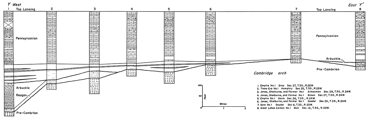
The lower Pennsylvanian sediments are shown to overlap beds as old as Pre-Cambrian on the crest of the Cambridge arch. This relation of overlap is similar on the eastern side of the arch as shown in well 8 with the overlap to the west instead of to the east.
The isopachous map of the Lansing-Stone Corral interval (Fig. 10) shows that the Lansing surface was tilted southeastward by the time of deposition of the Stone Corral. The dip on the Lansing was small, only about 10 feet per mile. Thickening of the beds into a salt basin in the area of the Central Kansas uplift (Lee, 1953, p. 21) may be a result of this southeast tilting. Several minor areas of thinning and thickening occur, especially on the Central Kansas uplift in the southeastern corner of the area. These minor structures have a northwest-southeast trend and do not correspond to any of the major tectonic structures. The Cambridge arch, Central Kansas uplift, Long Island syncline, Selden syncline, and other major structures show no evidence of movement during this time. It is possible that these minor structures were formed by differential compaction of the Pennsylvanian and Permian sediments. Some small anomalies may be due to salt flowage or faulting in the salt zone (Lee, 1953, p. 21). However, these effects are probably localized and of minor importance.
Figure 10—Isopachous map showing by 20-foot isopachs the thickness of the interval from the top of the Lansing group to the top of the Stone Corral formation.
The isopachous map of the interval between the Stone Corral and the Dakota is shown in Figure 11. The eastern limit of the Jurassic Morrison formation is shown on the map as well as the generalized eastern limit of the anhydrite which is present in the lower unit of the Morrison formation as described by Merriam (Merriam and Frye, 1954, fig. 2).
The map shows that there was movement on the Cambridge arch, Jennings anticline, and the southwestern end of the Stuttgart-Huffstutter anticlinal trend. Although movement occurred in the large synclinal area which separates the Cambridge arch from the Central Kansas uplift, no movement is apparent on the Long Island syncline and little, if any, on the Selden syncline.
Movement on the southern end of the Cambridge arch amounts to 60 to 100 feet in Norton County. Convergence maps prepared between the intervals of (1) the Stone Corral and the chert bed of the Morrison formation and (2) the chert bed and the Dakota formation indicate that most of the movement preceded the deposition of the Morrison chert.
An overall thickening of about 180 feet westward is indicated, as the interval increases from 920 feet on the east side to more than 1,100 feet on the west side of the area. This is a reflection of the preMorrison surface being tilted into the Denver basin. The Morrison formation was deposited on this surface overlapping Permian and Triassic (?) rocks eastward. The eastern extent of the anhydrite in the lower unit of the Morrison (as shown on Fig. 11) shows that the Cambridge arch must have been topographically high during its deposition since it does not cross the crest of the arch. The arch was finally buried by the deposition of the upper unit of the Morrison.
Figure 11—Isopachous map showing by 20-foot isopachs the thickness of the interval from the top of the Stone Corral formation to the top of the Dakota formation. The eastern limit of the Jurassic Morrison formation and the eastern limit of the anhydrite in the lower unit of the Morrison formation are also shown.
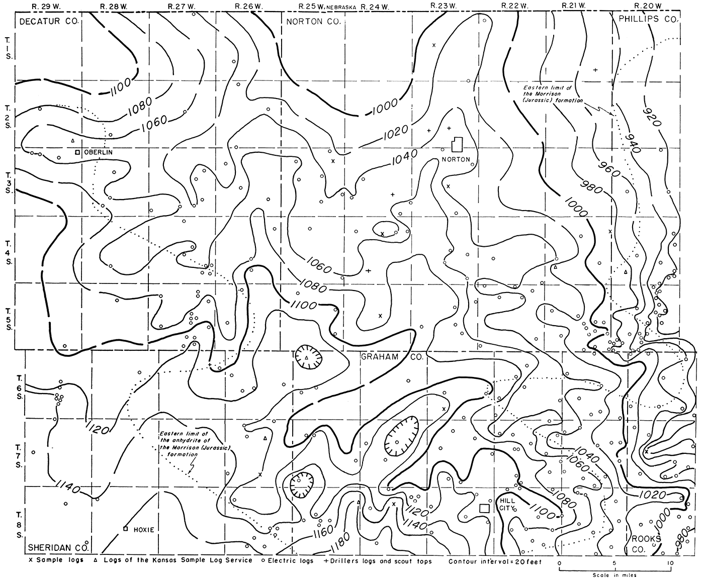
Lower Cretaceous rocks overstep the Permian, Triassic (?), and Jurassic rocks northward. In general, younger Cretaceous beds overlie the pre-Cretaceous surface toward the north. This surface was one of considerable topographic relief.
The isopachous map of the interval between the top of the Dakota formation and the base of the Fort Hays member is presented in Figure 12. The map shows that there was about 40 feet or more of structural movement on the Cambridge arch; however, none of the other major structures, such as the Jennings anticline, seem to have had any movement during this time. The many minor irregularities in the contours may be the result of differential compaction of the Cretaceous sediments. The control on the map is too sparse to determine if any of the minor structures had movement during this time.
Figure 12—Isopachous map showing by 20-foot isopachs the thickness of the interval from the top of the Dakota formation to the base of the Fort Hays limestone member of the Niobrara formation.
An isopachous map of the Niobrara formation shows that there was slight movement on the southern end of the Cambridge arch during that time (Lee and Merriam, 1954a, p. 18). However, the control is too limited to evaluate this development accurately because of the absence of the formation except in the extreme northwestern part of the State and there the information is scattered. As the distribution of the Pierre shale in Kansas is even more restricted, an isopach of this unit would be of even less value.
As all the structural maps up to and including the structure on top of the Niobrara formation reflect the same structure, and it is quite possible that the structure on the Pierre shale is also the same as on the other Cretaceous beds, it can be assumed that the beds were folded in post-Niobrara time. The closest date than can be determined for the folding in Kansas is post-Niobrara pre-Ogallala. This major structural movement may correspond to deformation of the Laramide revolution in the Rocky Mountain region. If this is true, then the folding in Kansas must have taken place between near the end of Cretaceous time and the early part of Tertiary time.
The structure on top of the "Algal limestone" is completely different from the structure on Cretaceous rocks, and reflects none of the major structural features of western Kansas. The structure is shown to be an eastward dipping homo cline with several minor structural noses and re-entrants which plunge eastward. At the end of the Cretaceous, the Mesozoic deposits in Kansas dipped northwestward into the Denver basin. This pattern was maintained and possibly accentuated during Cenozoic time. Western Kansas was then tilted eastward some time after the deposition of the "Algal limestone" (Merriam and Frye, 1954, p. 62),
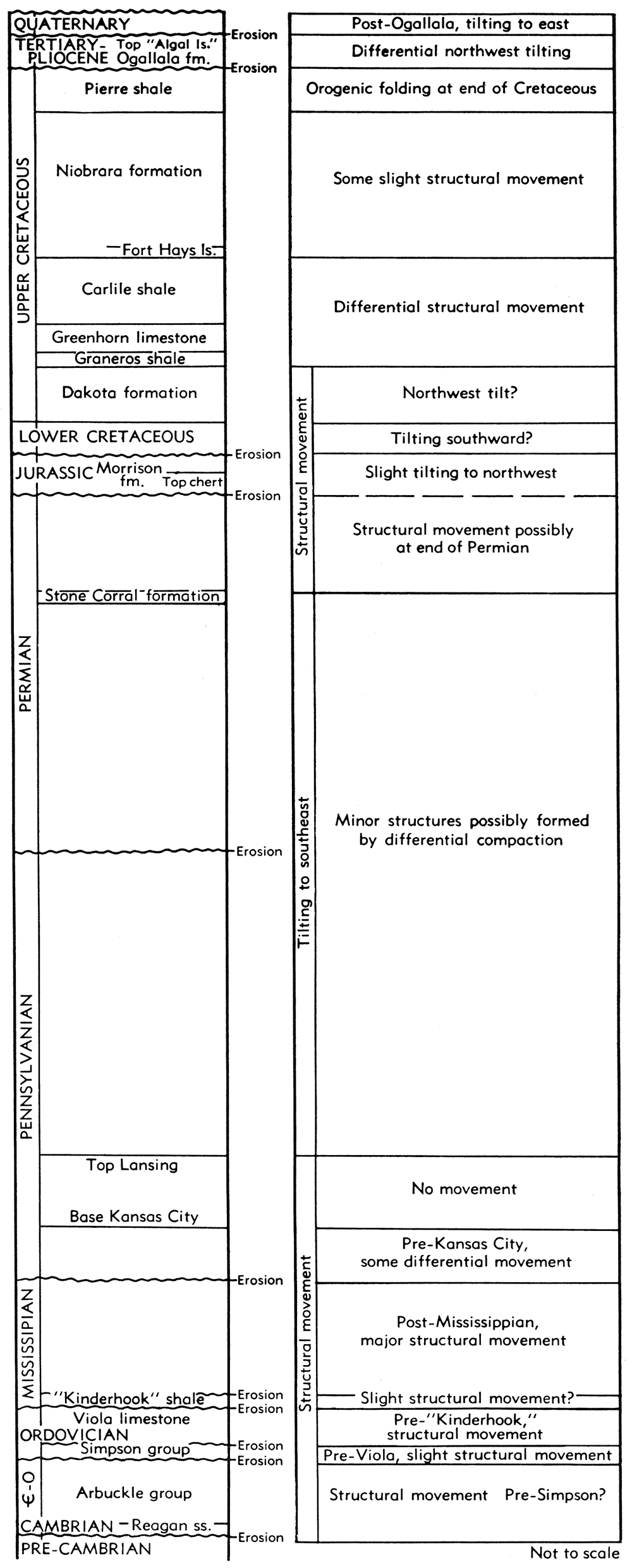
The structural development of the Cambridge arch and vicinity is summarized in chart form in Figure 13.
Figure 13—Summary of the structural development of the Cambridge arch and immediate vicinity. Not drawn to scale.
The oil-producing areas, including the names of the fields and the producing zone or zones, are shown in Figure 14. Ten fields produce from the Arbuckle, one from the Wabaunsee, one from the Shawnee, and the rest from the Lansing-Kansas City. The largest fields from the standpoint of cumulative production in descending order are the (1) Ray, (2) Adell, (3) Hansen, and (4) Studley. The fields with the largest 1953 production in descending order are (1) Ray, (2) Adell, (3) Hansen, and (4) Adell Northwest. The Ray and Penokee fields discovered in 1940 are the oldest. The Ray field had 154 producers in 1953 followed by Adell (38), Hansen (34), and Norton (30). More recent information on the Norton field showed 97 producing wells in August 1954 and the 1954 production should be more than half a million barrels of oil. This field, which was discovered in May 1953, has been developed rapidly and rates as one of the major discoveries in western Kansas in the last several years (Merriam and Goebel, 1954, p. 151). Pertinent information concerning the fields that are located in the area is summarized in Table 1.
Figure 14—Map showing the location of the oil fields within the area of the report. For "Monagnan" read Monaghan
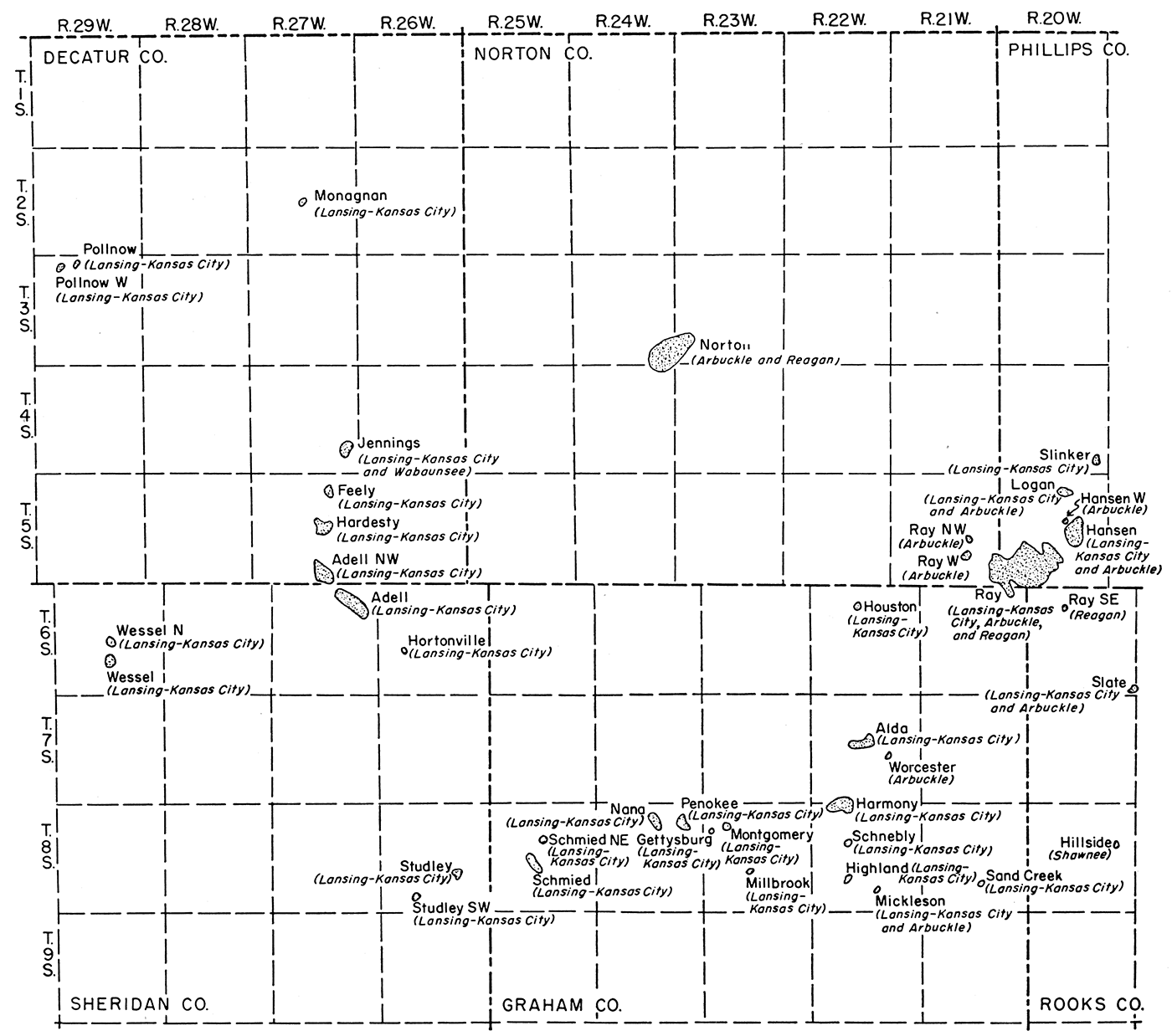
Table 1—Oil production data from fields located in the area of the report (Ver Wiebe and others, 1954).
| Pool name and date of discovery |
Location of discovery well |
Area, acres |
1953 production, bbls. |
Cumulative production to end of 1953, bbls. |
No. producing wells |
Producing zone |
Depth to producing zone, feet |
|---|---|---|---|---|---|---|---|
| Decatur County | |||||||
| Adell Northwest (1952) | 34-5-27W | 640 | 124,741 | 218,323 | 13 | Lans.-K.C. | 3,664 |
| Feely (1952) | 2-5-27W | 160 | 26,499 | 44,298 | 3 | Lans.-K.C. | 3,590 |
| Hardesty (1952) | 22-5-27W | 500 | 38,209 | 59,760 | 5 | Lans.-K.C. | 3,642 |
| Jennings (1951) | 25-4-27W | 720 | 48,858 | 91,017 | 11 | Wabaunsee | 3,156 |
| Lans.-K.C. | 3,478 | ||||||
| Monaghan (1952) | 15-2-27W | 40 | 3,702 | 5,392 | 1 | Lans.-K.C. | 3,514 |
| Pollnow (1953) | 4-3-29W | 40 | 6,180 | 6,180 | 1 | Lans.-K.C. | 3,734 |
| Pollnow West (1953) | 5-3-29W | 40 | 946 | 946 | 1 | Lans.-K.C. | 3,744 |
| Graham County | |||||||
| AIda (1944) | 15-7-22W | 700 | 13,792 | 43,034 | 4 | Lans.-K.C. | 3,518 |
| Gettysburg (1941) | 7-8-23W | 80 | 4,240 | 62,461 | 2 | Lans.-K.C. | 3,725 |
| Harmony (1951) | 32-7-22W | 700 | 54,637 | 85,145 | 9 | Lans.-K.C. | 3,597 |
| Highland (1951) | 20-8-22W | 40 | 2,150 | 8,103 | 1 | Lans.-K.C. | 3,616 |
| Houston (1947) | 9-6-22W | 40 | 1,031 | 19,516 | 1 | Lans.-K.C. | 3,506 |
| Mickleson (1952) | 27-8-22W | 80 | 7,604 | 13,553 | 1 | Lans.-K.C. | 3,502 |
| 4,213 | 1 | Arbuckle | 3,759 | ||||
| Millbrook (1951) | 21-8-23W | 40 | 3,572 | 13,722 | 1 | Lans.-K.C. | 3,761 |
| Montgomery (1953) | 8-8-23W | 40 | 316 | 316 | 1 | Lans.-K.C. | 3,504 |
| Nana (1953) | 4-8-24W | 40 | 486 | 486 | 1 | Lans.-K.C. | 3,738 |
| Penokee (1940) | 11-8-24W | 130 | 20,580 | 217,317 | 5 | Lans.-K.C. | 3,750 |
| Schmied (1952) | 21-8-25W | 780 | 41,324 | 59,070 | 9 | Lans.-K.C. | 3,740 |
| Schnebly (1952) | 8-8-22W | 40 | 6,717 | 10,811 | 1 | Lans.-K.C. | 3,507 |
| Worcester (1951) | 23-7-22W | 40 | 2,116 | 8,992 | 1 | Arbuckle | 3,792 |
| Norton County | |||||||
| Norton (1953) | 36-3-24W | 1,500 | 41,694 | 41,694 | 30 | Arbuckle | 3,778 |
| Ray Northwest (1953) | 22-5-21W | 40 | 156 | 156 | 1 | Arbuckle | 3,605 |
| Ray West (1945) | 26-5-21W | 200 | 25,744 | 131,068 | 5 | Arbuckle | 3,650 |
| Phillips County | |||||||
| Hansen (1943) | 14-5-20W | 980 | 214,220 | 2,159,046 | 34 | Lans.-K.C. | 3,363 |
| Arbuckle | 3,530 | ||||||
| Hansen West (1952) | 15-5-20W | 40 | 9,983 | 10,441 | 1 | Arbuckle | 3,543 |
| Logan (1945) | 3-5-20W | 420 | 31,946 | 378,729 | 12 | Lans.-K.C. | 3,149 |
| Arbuckle | 3,381 | ||||||
| Ray (1940) | 32-5-20W | 4,340 | 1,338,523 | 15,940,877 | 154 | Lans.-K.C. | 3,297 |
| Arbuckle | 3,575 | ||||||
| Reagan | 3,540 | ||||||
| Slinker (1951) | 25-4-20W | 200 | 27,076 | 59,656 | 5 | Lans.-K.C. | 3,215 |
| Rooks County | |||||||
| Hillside (1952) | 12-8-20W | 40 | 3,344 | 7,508 | 1 | Shawnee | 3,206 |
| Ray Southeast (1942) | 9-6-20W | 40 | 3,221 | 79,131 | 1 | Reagan | 3,600 |
| Slate (1951) | 31-6-19W | 120 | 8,340 | 14,086 | 3 | Lans.-K.C. | 3,291 |
| Arbuckle | 3,545 | ||||||
| Sheridan County | |||||||
| Adell (1944) | 11-6-27W | 1,200 | 308,901 | 2,974,334 | 38 | Lans.-K.C. | 3,755 |
| Hortonville (1953) | 20-6-26W | 80 | 8,154 | 8,154 | 2 | Lans.-K.C. | 3,789 |
| Studley (1943) | 23-8-26W | 340 | 16,810 | 396,463 | 6 | Lans.-K.C. | 3,810 |
| Studley Southwest (1945) | 32-8-26W | 40 | 10,298 | 53,381 | 1 | Lans.-K.C. | 3,758 |
| Wessel (1953) | 27-6-29W | 500 | 21,920 | 21,920 | 8 | Lans.-K.C. | 3,985 |
| Wessel North (1953) | 16-6-29W | 40 | 501 | 501 | 1 | Lans.-K.C. | 4,081 |
Two fields, Sand Creek and Schmied Northeast, discovered in 1954, do not appear in Table 1. The Sand Creek field was opened by the completion of the Schermerhorn Oil Corporation No. 1 Newell well in the SE NW NW sec. 27, T. 8 S., R. 21 W. in Graham County. Production is from the Lansing-Kansas City at a depth of 3,315 feet. The Schmied Northeast field was discovered by the Wentworth Oil and Development Company, Inc. No. 1 Walts well in the SW SW SW sec. 10, T. 8 S., R. 25 W. in Graham County. Production is from the Lansing-Kansas City at a depth of 3,720 feet.
In general, the Arbuckle producing fields show little relation to structure; that is, the Arbuckle does not necessarily produce from closed anticlinal highs. An example of this is the Norton field in Norton County where a detailed study by Merriam and Goebel (1954) showed that the trap is formed by a combination of truncation and overlap, change in porosity of the reservoir beds, and structure. Other Arbuckle producing fields-Mickleson, Worcester, and Slate-are not located on closed anticlines on the Arbuckle. The Ray, Hansen, and Logan fields, however, are on anticlinal highs on the Arbuckle structural map (Fig. 3). It seems that structure plays a role secondary to other more important conditions necessary for the accumulation of oil in the Arbuckle in the vicinity of the Cambridge arch.
The production from the Lansing-Kansas City as well as other Pennsylvanian production does show a close relation to structure, except in the southeastern part of the area. The Jennings, Feely, Hardesty, Adell Northwest, Adell, and Hortonville fields are located on the Jennings anticline. The Ray, Hansen, Hansen North, Logan, and Slinker fields are situated on the southwestern end of the Stuttgart-Huffstutter anticlinal trend. The Pollnow and Pollnow West fields are located on a prominent nose which detailed work would probably show to have closure. Other fields such as Studley, Schmied, Nana, Penokee, Harmony, Schnebly, Highland, and Alda seem to show no relation to the structure. All these fields are located either in the low broad synclinal area separating the Central Kansas uplift and the Cambridge arch or are on the Central Kansas uplift. They seem to show no relation to the structure but with more detail it is possible that some of the fields would show local anticlinal closure.
Arbuckle production seemingly is independent of structure; thus, the traps are probably stratigraphic. The production from the Lansing-Kansas City on the Cambridge arch and immediate vicinity generally occurs on closed anticlinal structures. In the southeastern part of the area, in the vicinity of the Central Kansas uplift, the production of oil from the Pennsylvanian beds seemingly has no relation to structure, and thus must be from stratigraphic traps.
Bass, N. W. (1926) Geologic structure of the Dakota sandstone of western Kansas: Kansas Geol. Survey Bull. 11, pt. 3, p. 84-89, fig. 27, pl. 7. [available online]
Clair, J. R., 1948, Preliminary notes on lithologic criteria for identification and subdivision of the Mississippian rocks in western Kansas: Kansas Geol. Soc., pp. 1-14, figs. 1-2.
Collins, J. B., 1947, Subsurface geologic cross section from Trego County, Kansas to Cheyenne County, Colorado: Kansas Geological Survey, Oil and Gas Investigations, no. 5, 8 p.
Darton, N.H., 1905, Preliminary report on the geology and underground-water resources of the Central Great Plains: U.S. Geol. Survey, Prof. Paper 32, pp. 1-409, figs. 1-18, pls. 1-72 (including maps). [available online]
Darton, N.H., 1918, Structure of a part of the Great Plains: U.S. Geol. Survey, Bull. 691-A, pp. 1-26, pls. 1-4. [available online]
Elias, M. K., 1931, The geology of Wallace County, Kansas: Kansas Geol. Survey Bull. 18, p. 1-254. [available online]
Fuenning, Paul, 1942, Thickness and structural study of major divisions of Cretaceous System in Nebraska: Am. Assoc. Petroleum Geologists Bull., vol. 26, no. 9, p. 1517-1536
Jewett, J. M., 1951, Geologic structures in Kansas: Kansas Geological Survey, Bulletin, no. 90 (1951 reports of studies), pt. 6, p. 105-172 [available online]
Landes, K. K., 1930, The geology of Mitchell and Osborne counties, Kansas: Kansas Geological Survey, Bulletin 16, 55 p. [available online]
Lee, Wallace, 1940, Subsurface Mississippian rocks of Kansas: Kansas Geol. Survey, Bull. 33, pp. 1-114, figs. 1-4, pls. 1-10. [available online]
Lee, Wallace, 1953, Subsurface geologic cross section from Meade County to Smith County, Kansas: Kansas Geological Survey, Oil and Gas Investigations, no. 9, 23 pages
Lee, Wallace, 1954, Thickness maps as criteria of regional structural movement: Kansas Geol. Survey, Bull. 109, pt. 5, p. 65-80. [available online]
Lee, Wallace, Leatherock, Constance, and Botinelly, Theodore, 1948, The stratigraphy and structural development of the Salina basin of Kansas: Kansas Geological Survey, Bulletin, no. 74, 155 p. [available online]
Lee, Wallace, and Merriam, D.F., 1954a, Preliminary study of the structure of western Kansas: Kansas Geological Survey, Oil and Gas Investigations, no. 11, 23 pages [available online]
Lee, Wallace, and Merriam, D.F., 1954b, Cross sections in eastern Kansas: Kansas Geological Survey, Oil and Gas Investigations, no. 12, 23 pages [available online]
Maher, J.C., 1946, Subsurface geologic cross section from Ness County, Kansas to Lincoln County, Colorado: Kansas Geological Survey, Oil and Gas Investigations, no. 2, 13 p.
Maher, J.C., 1947, Subsurface geologic cross section from Scott County, Kansas, to Otero County, Colorado: Kansas Geological Survey, Oil and Gas Investigations, no. 4, 11 p.
Maher, J.C., 1948, Subsurface geologic cross section from Baca County to Yuma County, Colorado: Kansas Geological Survey, Oil and Gas Investigations, no. 6, 11 p.
Maher, J.C., 1953a, Permian and Pennsylvanian rocks of southeastern Colorado: Am. Assoc. Petroleum Geologists Bull., vol. 37, no. 5.
Maher, J.C., 1953b, Paleozoic history of southeastern Colorado: Am. Assoc. Petroleum Geologists Bull., vol. 37, no. 11
Maher, J.C., and Collins, J.B., 1949, Pre-Pennsylvanian geology of southwestern Kansas, southeastern Colorado, and the Oklahoma panhandle: U.S. Geological Survey, Oil and Gas Investigations, Preliminary Map, no. 101, 4 sheets, scale 1:1,013,760 [available online]
McCoy, A. W., III, 1953, Tectonic history of Denver basin: Am. Assoc. Petroleum Geologists, Bull., vol. 37, no. 8, p. 1873-1893.
Merriam, D. F., 1955, Jurassic rocks in Kansas: American Association of Petroleum Geologists, Bulletin, vol. 39, no. 1, pp. 31-46
Merriam, D. F., and Frye, J. C., 1954, Additional studies of the Cenozoic of western Kansas: Kansas Geol. Survey, Bull. 109, pt. 4, p. 49-64. [available online]
Merriam, D. F., and Goebel, E. D., 1954, The geology of the Norton oil field, Norton County, Kansas: Kansas Geol. Survey, Bull. 109, pt. 9, p. 125-152. [available online]
Moore, R. C., Frye, J. C., Jewett, J. M., Lee, Wallace, and O'Connor, H. G., 1951, The Kansas rock column: Kansas Geological Survey, Bulletin, no. 89, 132 pages [available online]
Rubey, W. W., and Bass, N. W., 1925, The geology of Russell County, Kansas, with special reference to oil and gas resources: Kansas Geological Survey, Bulletin 10, pt. 1, p. 1-86 [available online]
Smith, H. T. U., 1940, Geologic studies in southwestern Kansas: Kansas Geol. Survey Bull. 34, p. 1-244. [available online]
Van Tuyl, F. M., Parker, B. H., and Fenwick, W. H., 1938, Geology and oil resources of eastern Colorado: Kansas Geol. Soc., Guidebook 12th Ann. Field Conf., p. 82-90
Ver Wiebe, W.A., 1941, Exploration for oil and gas in western Kansas during 1940: Kansas Geological Survey, Bulletin, no. 36, 109 pages
Ver Wiebe, W.A., 1942, Exploration for oil and gas in western Kansas during 1941: Kansas Geological Survey, Bulletin, no. 42, 122 pages
Ver Wiebe, W.A., 1943, Exploration for oil and gas in western Kansas during 1942: Kansas Geological Survey, Bulletin, no. 48, 86 pages
Ver Wiebe, W.A., 1944, Exploration for oil and gas in western Kansas during 1943: Kansas Geological Survey, Bulletin, no. 54, 102 pages
Ver Wiebe, W.A., 1945, Exploration for oil and gas in western Kansas during 1944: Kansas Geological Survey, Bulletin, no. 56, 112 pages
Ver Wiebe, W.A., 1946, Exploration for oil and gas in western Kansas during 1945: Kansas Geological Survey, Bulletin, no. 62, 112 p.
Ver Wiebe, W.A., 1947, Exploration for oil and gas in western Kansas during 1946: Kansas Geological Survey, Bulletin, no. 68, 11 p.
Ver Wiebe, W.A., and others, 1954, Oil and gas developments in Kansas during 1953: Kansas Geological Survey, Bulletin, no. 107, 204 p.
Wing, M. E., 1930, The geology of Cloud and, Republic Counties, Kansas: Kansas Geol. Survey, Bull. 15, p. 1-49, figs. 1-2, pls. 1-18. [available online]
Kansas Geological Survey
Placed on web Sept. 13, 2018; originally published in 1955.
Comments to webadmin@kgs.ku.edu
The URL for this page is http://www.kgs.ku.edu/Publications/Bulletins/OGI13/index.html