Kansas Geological Survey, OGI 12
Originally published in 1954 as Kansas Geological Survey Oil and Gas Investigations 12. This is, in general, the original text as published. The information has not been updated. An Acrobat PDF version (15 MB) is also available.
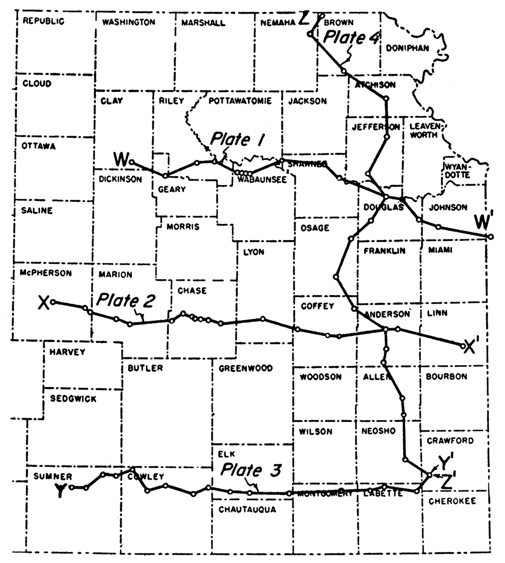
In recent years the State Geological Survey has presented generalized sections of the subsurface rocks of eastern Kansas (Jewett, 1949; Jewett and Abernathy, 1945). These earlier editions have been exhausted but the demand from operators and residents of eastern Kansas for this type of information has continued. Added interest in this area has been occasioned by secondary recovery operations and the relatively new techniques of hydraulic fracturing of reservoir rocks. The present group of four cross sections (Fig. 1) has been prepared in response to this demand. Each cross section is preceded by a sequence of diagrams in cross-section form to show the structural developments at the successive periods of regional deformation that have led to the present structure and distribution of the formations.
Figure 1—Index map showing location of cross sections.
Because of the limited number of good well samples and logs in eastern Kansas, it has been necessary to draw the cross sections where the best control is available. As a result, the cross sections are not drawn uniformly on straight lines and do not cross the major structural features at right angles. A cross section along an irregular line on an inclined surface suggests structural features not actually present. Distortion from this source is minimized by the small scale and generalized character of the cross sections. An unavoidable distortion results from vertical exaggeration, in this case 100 times the horizontal scale. To present the cross sections more nearly in their true proportions the present relations of the formations are shown at the bottom of Plates 1, 2, and 3 with a vertical exaggeration of only twice that of the horizontal scale.
In the preparation of the cross sections sample logs were used wherever possible but in southeastern Kansas, in the absence of sample logs in appropriate places, a few drillers logs were used after checking against other logs in the same vicinity. In all 68 logs were used, most of which were sample logs from the files of the Kansas Geological Survey. Details of the distribution and wedging out of formations between wells of the cross sections were derived largely from earlier reports by the U.S. Geological Survey in cooperation with the Geological Surveys of Kansas, Missouri, Iowa, and Nebraska (Lee and others, 1946) and the Kansas Geological Survey (Lee, Leatherock, and Botinelly, 1948).
The stratigraphy of eastern Kansas is discussed only briefly in this report. For more detailed descriptions of the rocks the reader is referred to Moore and others (1951).
Pink granite is reported in most of the wells that have been drilled to Pre-Cambrian rocks, but quartzite, schist, gneiss, porphyry, slate, and marble have also been reported. A revised map roughly showing the configuration of top of the Pre-Cambrian in eastern Kansas has been published recently (Jewett, 1954).
The Pre-Cambrian rocks are nearly everywhere overlain by the Lamotte sandstone. This formation is a basal Paleozoic sand which was deposited on a surface of moderate relief. Local areas were too high to be submerged during Lamotte deposition. The sandstone is composed mainly of white fine- to coarse-grained angular to subrounded quartz fragments. A thickness of 40 feet is reported in well 6 of Plate 2.
The Arbuckle group, of Late Cambrian and Early Ordovician age, consists of five recognizable divisions in the subsurface of eastern Kansas. The lower two—the Bonneterre dolomite and the Eminence dolomite—are Cambrian in age whereas the upper three—the undivided Gasconade dolomite and Van Buren formation, the Roubidoux dolomite, and the undivided Cotter and Jefferson City dolomites—are of Ordovician age. The Arbuckle group as a whole consists mainly of dolomite and is white, buff, light gray, cream, and brown in color. The rocks are usually crystalline or dense, and especially in the upper parts contain large amounts of various types of chert. Some of the beds are sandy and some contain minor amounts of glauconite and pyrite. A thickness of 880 feet was reported in wells 16 and 17 of Plate 3. Where the Lamotte sandstone is missing Arbuckle rocks overlie the Pre-Cambrian surface. In general, the Arbuckle thickens to the east and southeast toward the Ozark region of Missouri and toward the south in Oklahoma.
Rocks of Ordovician age that are present in eastern Kansas include the Simpson group, the Viola limestone, and the Maquoketa shale.
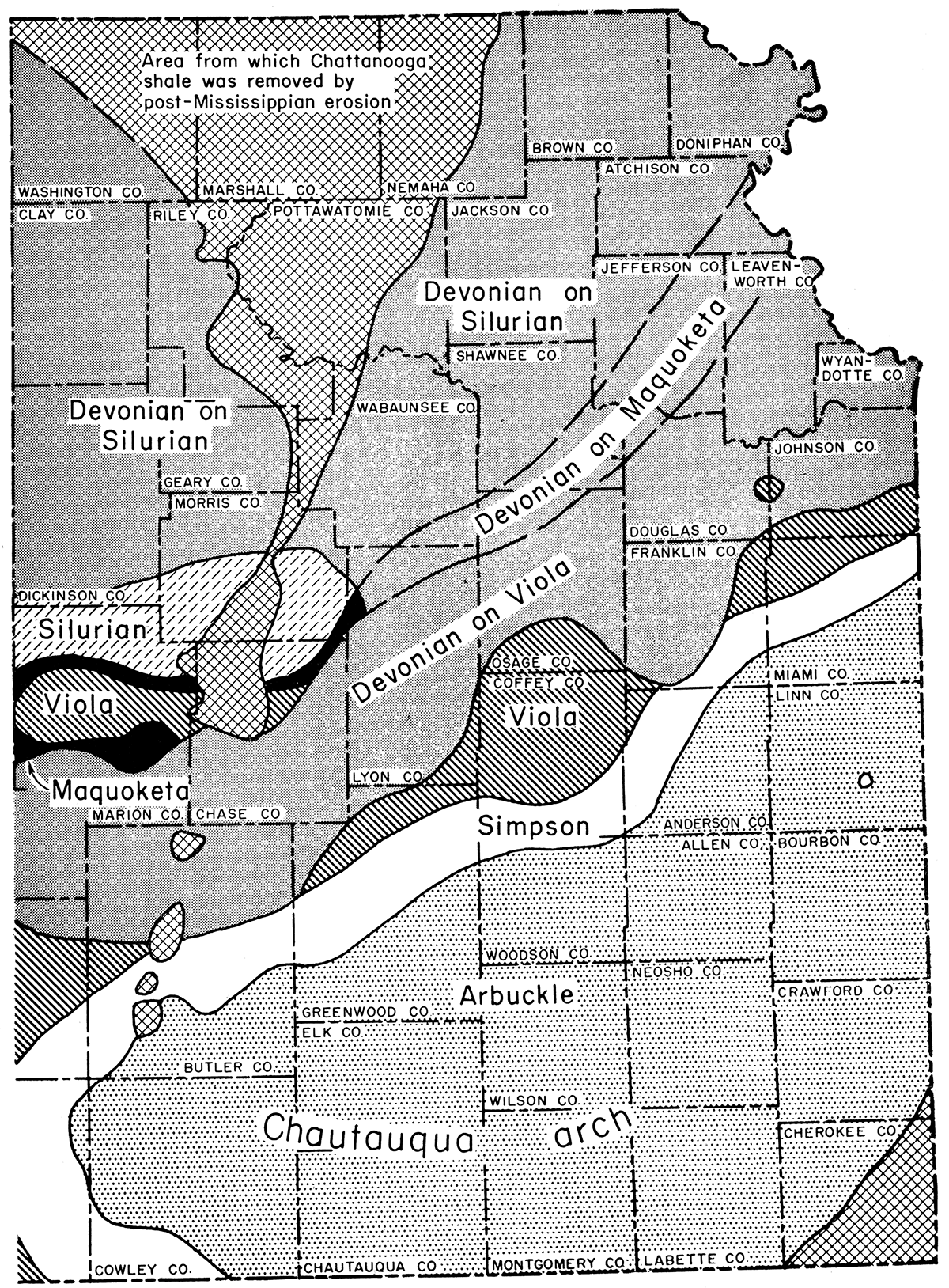
The Simpson group is composed of gray to white fine-grained subrounded sandstone, green shale, and gray to brown dense finely crystalline sandy dolomite. A thickness of 210 feet is present in well 1 of Plate 4. An abnormal thickness of Simpson was found in wells 15 and 19 of Plate 2. Similar abnormal thicknesses of Simpson sand have been noted in eastern Kansas by Lee and others (1946) who attributed them to deposition in sinkholes on the Arbuckle surface. Generally speaking the Simpson group thins to the east. It was truncated by postSimpson erosion on the flank of the Chautauqua arch. The pre-Chattanooga outcrop of the Simpson group is shown in Figure 2.
The Viola limestone consists of gray, buff, and brown medium to coarse crystalline dolomite, mite, which is usually vuggy and contains varying amounts of gray and white opaque generally spicular chert. This formation attains a thickness of 180 feet in well 4 of Plate 4, and thins to the southeast on the flank of the Chautauqua arch.
The Maquoketa shale is gray-green to gray silty dolomitic shale with gray fine granular silty dolomite. It is locally cherty. The Maquoketa attains a thickness of about 80 feet in well 3 of Plate 4. This formation, where present, maintains a rather uniform thickness.
The Silurian rocks consist of light-gray to buff fine- to medium-crystalline dolomite which is locally very vuggy and porous. Chert is also present in varying amounts. The base of the Silurian is characterized by large dolomitized oolites. A thickness of 430 feet occurs in well 2 of Plate 4. The Silurian thins to the south and to the east.
It is common practice to group together the Devonian and Silurian rocks in a unit called the "Hunton" limestone. The rocks of these two systems are lithologically similar in some areas but they are separated by an important unconformity. In Kansas and Missouri the contact between the Devonian and the Silurian occurs at the base of a dolomite or limestone zone in which rounded sand grains are disseminated. The basal bed is locally a dolomitic sandstone. The Devonian in eastern Kansas commonly includes gray to brownish dense to finely crystalline dolomite or sublithographic limestone. Except where it is very thin, it includes some opaque white chert. It is 240 feet thick in well 4 of Plate 4. From north to south, as the Chautauqua arch in southeastern Kansas is approached, the Devonian rocks overlap from the Silurian onto older rocks (Fig. 2).
Figure 2—Distribution of formations likely to be encountered immediately below the Chattanooga shale in eastern Kansas.
The Chattanooga shale is greenish-gray to medium gray, platy, and pyritic. The lower part is a spore-bearing dark-gray to black shale. Locally there occurs at the base of the Chattanooga a gray fine- to medium-grained slightly friable sandstone known as the Misener sand, generally represented in eastern Kansas by sandy shale. In general the Chattanooga overlaps upon all the older beds in eastern Kansas. Abnormal thicknesses of this unit have been described (Lee, Leatherock, and Botinelly, 1948) in McPherson County and eastward where it was deposited in an old bedrock valley but in southeastern Kansas it wedges out to a featheredge in Cherokee County. A thickness of 260 feet of Chattanooga shale occurs in well 9 of Plate 1.
The Mississippian System, which is undivided in this report, includes a number of recognizable formations (Lee, 1940). These formations are grouped into four series—the Kinderhookian, Osagian, Meramecian, and Chesteran-which either singly or collectively are present in all of eastern Kansas except on the northern end of the Nemaha anticline. For the most part the Mississippian rocks consist of limestone and dolomite. The limestone is gray, finely to medium crystalline, slightly dolomitic, and cherty in part. The dolomite is white to buff, sucrose to finely crystalline, and cherty. Some of the dolomite is vuggy with drusy quartz. Varying amounts of glauconite are present and one limestone member is oolitic. Some greenish-gray silty shale is present in the Kinderhookian and some greenish and reddish shales occur locally in the lower part of the Osagian Series. The Mississippian rocks are about 420 feet thick in well 15 of Plate 1.
The Pennsylvanian rocks in eastern Kansas are represented by the Desmoinesian, Missourian, and Virgilian Series which are subdivided into groups, formations, and smaller named units.
The Desmoinesian Series consists of the "Cherokee" and Marmaton groups. The "Cherokee" rocks are predominantly dark-gray to black micaceous shale with varying amounts of sandstone, thin limestones, and coal. The sandstone is gray, fine- to medium-grained, subangular, and friable. The limestone is brown and dense to medium crystalline. A deposit of sand and chert present locally at the base of the Desmoinesian is called "Burgess sand" or Pennsylvanian basal conglomerate. The thickness of the "Cherokee" is about 560 feet in well 9 of Plate 1. The Marmaton group consists of gray sandy shale with gray, cream,' and buff dense to finely crystalline limestone. There is some red, green, and black shale especially in the lower part of the group. The thickness in well 18 of Plate 4 is about 230 feet. For the most part, the group has a rather constant thickness in eastern Kansas.
The Missourian Series consists of the Pleasanton, Lansing, and Kansas City groups. The Pleasanton group consists mainly of gray gritty platy micaceous shale and gray fine-grained micaceous subangular sandstone. Some red and green shale also is present in some of the wells. This group has a thickness of about 180 feet in well 13 of Plate 3. Generally the group has a fairly uniform thickness over most of the eastern part of the State. The Lansing and Kansas City groups, which have not been separated in this report, are composed mostly of gray to buff dense to finely crystalline limestone interstratified with gray limy shale, red and green shale, and black shale. Some of the limestones are oolitic and some are cherty. Fine-grained silty calcareous sandstone is also present. The Hertha limestone, a well-known formation at the base of the Kansas City group, is gray to brown, granular, and dense. The Lansing group which is predominantly limestone in the north grades laterally into a sandy facies toward the south. This sandy facies, which is a partial equivalent of the "Stalnaker sand," is light gray, fine-grained, subangular, micaceous, and shaly in streaks. The total thickness of the two groups increases to the south, where in well 10 of Plate 3 the thickness is 700 feet.
The Virgilian Series contains the Douglas-Pedee, Shawnee, and Wabaunsee groups. The Douglas-Pedee group consists mainly of red and medium- to dark-gray shale with gray fine-grained micaceous subangular sandstone and some gray to buff dense to finely crystalline limestone. The thickness of this group is about 380 feet in well 12 of Plate 3. The Shawnee group is composed of gray and cream to tan dense to fine crystalline limestone with some interbedded dark-gray, red and gray, and black shale. The lower part of the group is cherty. The Heebner is a thin black shale which occurs in the lower part of the group and is a recognizable marker horizon especially in electric well logs. The Shawnee group attains a thickness of 560 feet in well 3 of Plate 3. The Wabaunsee group consists of white to gray finely crystalline limestone with interbedded red and gray sandy shale. Some of the limestone is cherty. There are also varying amounts of gray fine-grained subangular micaceous sandstone. The thickness of this group is 560 feet in well 7 of Plate 3.
Only the lower two Permian series—the Wolfcampian and Leonardian—are present in eastern Kansas. The Admire, Council Grove, and Chase groups make up the Wolfcampian; only the lower part of the Sumner group of the Leonardian Series is present.
The Admire group is composed of gray to buff mottled finely crystalline cherty limestone, red and gray sandy shale, and gray fine-grained micaceous subangular sandstone. This group attains a thickness of 210 feet in wells 1 and 2 of Plate 4. The Council Grove group consists of gray, light-gray, and cream dense to finely crystalline limestone with interbedded gray shale. Some of the limestones are cherty and dolomitic. This group has a thickness of 360 feet in well 6 of Plate 3. The Chase group includes buff to brown finely crystalline dolomitic limestone and red and gray shale. White to white and gray anhydrite occurs in the upper part of the group. The Chase group is 390 feet thick in well 4 of Plate 3.
The Sumner group of the Leonardian Series consists mainly of red and gray shale with minor amounts of limestone and anhydrite. Only the lower formations of this group are represented in the northwestern corner of the area.
The present regional structure of eastern Kansas is the result of several conflicting structural movements that warped the originally flat formations in different directions at differing periods of geologic history (Lee and others, 1946; Lee, 1943; Lee, 1940; Lee, Leatherock, and Botinelly, 1948). A brief summary of the structural movements affecting eastern Kansas follows.
The first Paleozoic structural movements occurred during Arbuckle time when eastern Missouri was a subsiding basin in which a great thickness of marine dolomite was being deposited. At the same time eastern Kansas was sinking more slowly with lesser accumulations of similar sediments. At the end of Arbuckle time areas in northeastern Kansas and southeastern Nebraska were raised so high above sea level that all the Arbuckle rocks down to the Pre-Cambrian were eroded from the crest of what is known as the Southeast Nebraska arch. The surface of this arch and other areas of Kansas were worn down to a more or less level plain upon which the Simpson rocks were deposited.
During the second period of regional deformation the structural movements were reversed. The Southeast Nebraska arch became a subsiding area known as the North Kansas basin and the Ozark region of Missouri and the Chautauqua arch of southeastern Kansas began to rise. These movements continued with only slight variations from Simpson to Chattanooga time. They were, however, interrupted by uplift and erosion at the end of Silurian time and again preceding the deposition of the Chattanooga shale. During both these intervals the region was uplifted and worn down by erosion to a nearly level plain. The older rocks which had been tilted toward the North Kansas basin were beveled and exposed in parallel bands on the level surface. The Devonian rocks were deposited on such a surface. They overlie the eroded surface of the Silurian in the North Kansas basin and, toward the Chautauqua arch in southeastern Kansas, were laid down in succession across the exposed belts of Maquoketa (Sylvan), Viola, Simpson, and originally on the Arbuckle. The Chattanooga shale was deposited across a similar eroded surface. It overlies the Devonian limestones and dolomites in the North Kansas basin and overlaps toward the south upon the Viola and the Simpson and on the crest of the Chautauqua arch upon the Arbuckle. The Silurian and the Maquoketa (Sylvan) were not reexposed at this time except in a broad valley in McPherson and Marion Counties which was eroded below level of the pre-Chattanooga plain to the east (Fig. 2).
The third period of regional deformation affecting eastern Kansas began at the end of Mississippian time when the Nemaha anticline arched the already deformed older rocks in a long narrow fold extending from Omaha southwest beyond Oklahoma City. The elevated areas were again beveled by erosion and all rocks younger than the Pre-Cambrian were eroded from its crest in northeastern Kansas. In other areas on its crest, rocks older than the Pennsylvanian were greatly reduced in thickness. Before Pennsylvanian rocks were deposited in eastern Kansas, movement along the Nemaha anticline was renewed in the same pattern of folding. This renewed activity lowered the beveled surface east of the anticline and produced the Forest City basin in northeastern Kansas and its southern counterpart, the Cherokee basin of southeastern Kansas. Much greater thicknesses of lower Pennsylvanian rocks accumulated in these basins than covered the crest of the Nemaha anticline. Secondary movements on the anticline and in the adjacent basins continued through Pennsylvanian and Permian time and even later. Later structural movements, in the main post-Permian, gave the rocks of eastern Kansas their present low dip toward the west and northwest.
The bottom cross sections of Plates 1 to 4 show the present attitude of the formations in eastern Kansas. The series of diagrams in the form of cross sections that are shown in the upper parts of the plates reveal the steps by which the somewhat complicated relations of the present evolved. Previous work has shown that some of the erosional surfaces separating the formations were originally essentially flat and horizontal. Such topographic relief as existed on the eroded surfaces is in the main negligible over long distances. By plotting the formations with reference to successive essentially flat and horizontal surfaces the development and modification of the different regional structural features are revealed.
Cross section W-W' (Pl. 1) extends from west to east from Clay County, Kansas, to Cass County, Missouri, approximately 145 miles (Fig. 1).
Plate 1A shows the attitude of the rocks on the line of the cross section at the close of Simpson time, indicating the beveled crest of the Southeast Nebraska arch below the overlapping Simpson rocks between wells 4 and 8 and the thickening of the Arbuckle group eastward into Missouri.
Plate 1B shows the attitude of the rocks at the end of Maquoketa time with little or no change in structure of the Arbuckle on the line of the cross section.
Plate 1C shows the attitude of the formations at the beginning of Devonian deposition-the pre-Devonian beveling of the older rocks, the early subsidence of the North Kansas basin between wells 2 and 11, and the accompanying rise of areas to the east which materially reduced the eastward dip of the Pre-Cambrian surface.
Plate 1D shows the attitude of the formations at the beginning of the deposition of Mississippian limestones. It reveals the continued subsidence of the North Kansas basin through the period of deposition of the Chattanooga shale and the loss of the original easterly dip of the Pre-Cambrian surface.
Plate 1E shows the attitude of the formations after post-Mississippian beveling. The section shows the initial development of the Nemaha anticline across the area of the North Kansas basin; a broad syncline to the east (the forerunner of the Forest City basin) and the east limb of a syncline to the west (the forerunner of the Salina basin). Easterly dip in some measure has been restored to the Pre-Cambrian surface.
Plate 1F shows the attitude of the formations at the beginning of Kansas City time. It shows the downwarping of the post-Mississippian peneplain to form the Forest City basin on the east and the margin of the shallower Salina basin on the west.
Plate 1G shows that at the end of Lansing time there had been only slightly increased arching of the Nemaha anticline.
Plate 1H shows the present attitude of the formations. It reveals that slow development of the Nemaha anticline and the Forest City basin continued after Lansing time and probably through the Permian. The most striking feature is the westerly dip which was imposed on the earlier structure after Permian time. The Pre-Cambrian surface has acquired a strong westerly dip interrupted by the Nemaha anticline.
Plate 1J shows the present attitude of the formations with a vertical exaggeration only twice that of the horizontal. The cross section reveals the improbability of faulting on the east flank of the Nemaha anticline.
Cross section X-X' (Pl. 2) extends from west to east from McPherson County to Linn County, Kansas, approximately 150 miles (Fig. 1).
Plate 2A shows the attitude of the formations on the line of the cross section at the beginning of Mississippian limestone deposition. Between wells 1 and 5 the diagram shows the pre-Chattanooga valley filled by a thick accumulation of Chattanooga shale. The shale thins eastward and overlaps in succession upon Devonian, Viola, Simpson, and Arbuckle rocks.
Plate 2B shows the attitude of the formations after post-Mississippian beveling. The initial development of the Forest City basin, Salina basin, and the Nemaha anticline and the greater displacement of the Mississippian rocks on the east than on the west are indicated.
Plate 2C shows the attitude of the formations at the beginning of Kansas City time—the downwarping of the post-Mississippian peneplain, the development of the Forest City-Cherokee basin, slightly increased arching on the crest of the Nemaha anticline, and more or less static conditions in the Salina basin—on the line of the cross section.
Plate 2D shows that by the end of Lansing time there had been only slightly increased structural movement.
Plate 2E shows the present attitude of the formations, revealing renewed activity of the Nemaha anticline during Permian time, additional deepening of the Forest City-Cherokee basin, and the post-Permian westerly dip of the whole region.
Plate 2F shows the present attitude of the formations with a vertical exaggeration only twice that of the horizontal.
Cross section Y-Y' (Pl. 3) extends from west to east from Sumner County to Crawford County, Kansas, a distance of 135 miles (Fig. 1).
Plate 3A shows the attitude of the formations at the beginning of Mississippian limestone deposition. It portrays the overlap of the Chattanooga shale upon the Simpson on the border of the Chautauqua arch and upon the Arbuckle on its crest, and also illustrates the southeastward thinning of the Chattanooga.
Plate 3B shows the attitude of the formations after post-Mississippian beveling indicating the relatively low arching of the Nemaha anticline in southern Kansas by the slight thinning of the Mississippian across its crest.
Plate 3C shows the attitude of the formations at the beginning of Kansas City time. There has been increased arching of the Nemaha anticline and downwarping to form the Cherokee basin in the area of the previously rising Chautauqua arch.
Plate 3D shows the present structure of the formations on the line of the cross section. There has been only slightly increased arching of the Nemaha anticline since Kansas City time. The principal structural feature is the post-Permian westerly dip.
Plate 3E shows the present structure with a vertical exaggeration of only twice the horizontal scale.
Cross section Z-Z' (Pl. 4) extends from northwest to southeast from Brown County to Crawford County, Kansas, a distance of 195 miles (Fig. 1). This cross section is designed to show primarily the relation of the North Kansas basin to the Chautauqua arch and the southerly overlap of the Devonian rocks and the Chattanooga shale. Inasmuch as the cross section lies on the trend of the Forest City-Cherokee basin and parallel to the trend of post-Mississippian structural movements, the later cross sections (Pls. 4C to 4E) do not reveal post-Mississippian structure.
Plate 4A shows the attitude of the formations at the beginning of Devonian time. It reveals thickening of the Simpson and Silurian rocks toward the center of the North Kansas basin, and the southward beveling of the Silurian, Maquoketa, Viola, and originally also of the Simpson and Arbuckle as the Chautauqua arch is approached.
Plate 4B shows the attitude of the formations at the beginning of Mississippian limestone deposition, indicating the continued development of the North Kansas basin through Chattanooga time. The Devonian, Viola, Simpson, and Arbuckle rocks were beveled by pre-Chattanooga erosion between wells 9 and 12 but the Silurian and Maquoketa were not reexposed.
Plate 4C shows the attitude of the formations after post-Mississippian beveling. The Mississippian limestones are thin in wells 1 and 2 because they were drilled on the east flank of the rising Nemaha anticline which is not otherwise represented in this cross section because it lies entirely in the Forest City-Cherokee basin. There was no movement of the Chautauqua arch. Well 10 is in a broad shallow syncline.
Plate 4D shows the attitude of the formations at the beginning of Kansas City time. The zigzag course of the cross section (Fig. 1) introduces irregularities in the thickness of the lower Pennsylvanian rocks that do not reflect the structural features of the Forest City-Cherokee basin.
Plate 4E shows the present attitude of the formations. Wells 10 to 18 are on a component of the northwesterly dip that was imposed on this and other areas of Kansas mainly in post-Permian time. Wells 5 to 10 are approximately on the strike of the post-Permian dip.
Jewett, J. M., 1949, Oil and gas in eastern Kansas; with special reference to developments from 1944 to 1948: Kansas Geol. Survey, Bull. 77, 308 p.
Jewett, J. M., 1954, Oil and gas in eastern Kansas: Kansas Geol. Survey, Bull. 104, 397 p
Jewett, J. M., and Abernathy, G. E., 1945, Oil and gas in eastern Kansas: Kansas Geol. Survey, Bull. 57, 244 p
Lee, Wallace, 1940, Subsurface Mississippian rocks of Kansas: Kansas Geol. Survey, Bull. 33, pp. 1-114, figs. 1-4, pls. 1-10. [available online]
Lee, Wallace, 1943, The stratigraphy and structural development of the Forest City basin in Kansas: Kansas Geological Survey, Bull. 51, 142 p. [available online]
Lee, Wallace, Leatherock, Constance, and Botinelly, Theodore, 1948, The stratigraphy and structural development of the Salina basin of Kansas: Kansas Geological Survey, Bulletin, no. 74, 155 p. [available online]
Lee, Wallace, and others, 1946, Structural Development of the Forest City Basin of Missouri, Kansas, Iowa, and Nebraska: U. S. Geol. Survey, Oil and Gas Investi., Prelim. Map 48 [available online]
Moore, R. C., Frye, J. C., Jewett, J. M., Lee, Wallace, and O'Connor, H. G., 1951, The Kansas rock column: Kansas Geological Survey, Bulletin, no. 89, 132 pages [available online]
Kansas Geological Survey
Placed on web Sept. 13, 2018; originally published in 1954.
Comments to webadmin@kgs.ku.edu
The URL for this page is http://www.kgs.ku.edu/Publications/Bulletins/OGI12/index.html