![]()
Prev Page--Geomorphology || Next Page--Ground Water
Geology in Relation to Ground Water
Paleozoic Rocks
Missourian and Virgilian rocks of Pennsylvanian age crop out in the mapped area. These are underlain by older Paleozoic rocks having an average thickness of about 2,100 feet. Subsurface rocks include formations of the Pennsylvanian, Mississippian, Devonian, and Cambro-Ordovician Systems, dipping gently westward.
Three groups of Pennsylvanian rocks were mapped: Kansas City, Lansing, and Douglas. No attempt was made to study Pennsylvanian rocks or their contained ground water in detail. Most ground water obtained from bedrock in this area is scanty and poor in quality. Nevertheless, most upland farms in the mapped area rely upon bedrock as the source for their domestic and stock water. Prolonged periods of drought dry up many bedrock wells and create a serious rural water shortage. Where the depth to the water table is less than 20 feet, wells may be dug, but where the static water level lies at much greater depths drilling is more economical.
Owing to the diverse nature of the strata, a simple and continuous water table does not exist in Pennsylvanian bedrock. Most water-bearing formations consist of permeable sandstone or limestone containing abundant solution cavities. Where a saturated permeable rock is confined between two impervious beds the static water level in wells is higher than the top of the permeable layer. Just back of the bluffs of the Kansas River valley, where gullies and streams have dissected the bedrock formations deeply, an adequate supply of ground water can be obtained only by drilling into a saturated permeable rock lying at elevations below the depth of valley incision.
Kansas City Group
Zarah Subgroup--The Zarah Subgroup, consists of a thick compact limestone formation, containing two thin shale members, and less prominent shale formations above and below the limestone (Pl. 5C). Moderate supplies of ground water of fair to poor quality are obtained from the thick limestone members.
Lansing Group
The Lansing Group comprises two prominent limestone formations separated by a relatively thin shale formation (Pl. 7B). Interbedded shale and limestone are characteristic of a large portion of the group. Ground-water supplies from the Lansing Group are small, owing to the thinness of the limestone beds within the group.
Douglas Group
The Douglas Group is the thickest and most extensive bedrock group that crops out in the area. It consists chiefly of thick shale formations containing massive cross-bedded sandstone members and minor limestone members and coal beds. Sandstone members of the Douglas Group. are the best bedrock aquifers in the area. The Tonganoxie Sandstone member of the Stranger Formation is a basal channel sandstone, which locally yields large supplies of ground water of good quality near the outcrop, but the erratic distribution of permeable zones and the variable quality of the water reduce its value as an aquifer.
Quaternary Deposits
Pre-Kansan Gravel
High-level chert gravel deposits are located on hill crests on both the north and south bluff of the Kansas River valley. These deposits are deeply weathered and generally much less than 5 feet thick. A chert gravel deposit is found at lower elevation under-lying glacial outwash along the south bluff of Wakarusa River. All deposits consist predominantly of subangular chert pebbles ranging from 1/2 to 2 inches in diameter and contained in a red sandy-clay matrix. No glacial erratics have been found imbedded in any of these deposits, although a few granite and quartzite cobbles were found associated with deeply weathered outcrop debris of high-level gravels. The low-level deposit underlies outwash silts of Kansan age, but it is lithologically dissimilar from outwash gravels found at the base of Menoken Terrace deposits in other areas. The high topographic position and absence of glacial erratics date the high-level chert gravel deposits as pre-Kansan-late Tertiary or early Pleistocene age. The chert pebbles are typical of Pennsylvanian and Permian bedrock cropping out between the mapped area and the line of outcrop of the Herington Limestone of late Wolfcampian age (Frye and Walters, 1950). These gravels are thought to have been deposited in preglacial stream valleys of a drainage system lying entirely east of the Flint Hills region; the drainage of northeastern Kansas did not extend west of that divide area until after the invasion of the Kansan glacier into northeastern Kansas.
The lower-lying chert gravel deposit is very thin, is composed of discontinuous lenticular bodies, few of Which attain a thickness of 3 feet, and is limited to an outcrop length of about 1/2 mile. This deposit differs lithologically from the other chert gravels in its slightly lesser degree of leaching and weathering; a few limestone, sandstone, and shale pebbles were found. The lack of glacial erratics, its position between Pennsylvanian bedrock and Kansan outwash, and the thin and localized nature of the deposit suggest a pre-Kansan origin. Locally derived and transported gravels were deposited within a local drainage basin prior to glaciation. Meltwaters from the periphery of the approaching Kansan glacier entered the valleys and initiated a period of incision that swept out most prevailing stream deposits. Some preglacial deposits remained, however, because the dominant process was rapid downcutting rather than lateral planation. Many tributary valleys, especially to the south of the principal valley, were left stranded at high levels. During the subsequent advance and retreat of the Kansan glacier, outwash buried and preserved the chert gravel deposit.
These deposits are too thin and localized to provide a source for ground water.
Atchison Formation
Sand and gravel of the Atchison Formation have not been positively identified in the area. As this member represents pro-glacial outwash (Moore and others, 1951), a conformable relationship of Atchison Formation and overlying Kansas Till must be demonstrated clearly before conclusive identity can be established.
Kansas Till
Large portions of the uplands are blanketed with glacial till. It consists of a spotty thin veneer of weathered clay or isolated cobbles and boulders in some places, but is found as thick till deposits in others. Inasmuch as the upland area is covered with a dense vegetal mantle, and as outcrops generally are limited to small gullies and shallow ditches, the glacial till as mapped includes some colluvially reworked till. For this reason the extent of till deposits undoubtedly is exaggerated at some localities. The upland area south of Kansas River in the southeastern portion of the area is known to be discontinuously mantled with thin and patchy deposits of till and loess, but only clearly defined till deposits were mapped in that area because the lack of freshly scraped ditches made surface mapping almost impossible.
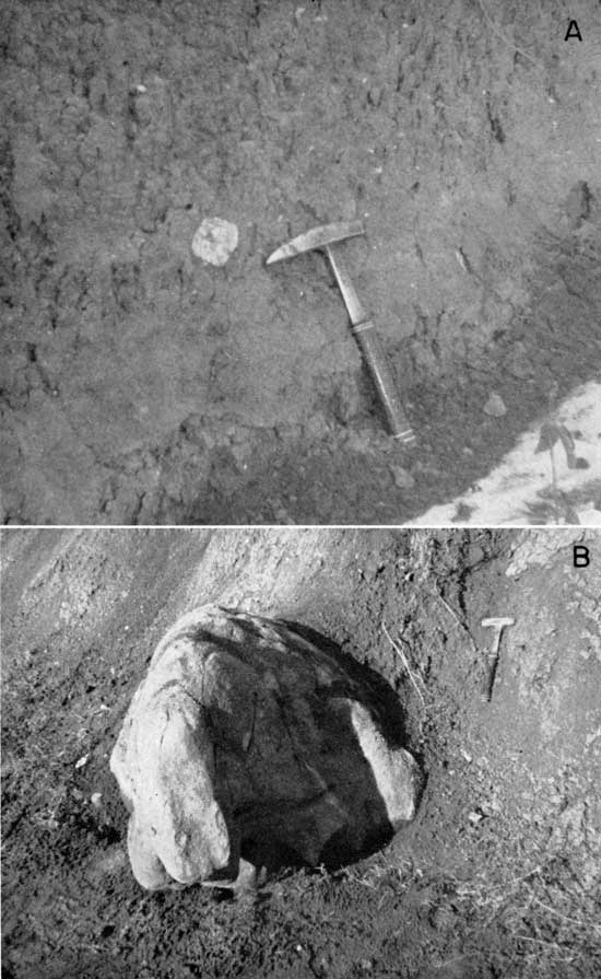
The till observed in the area is a heterogeneous accumulation of boulders, cobbles, and pebbles composed of granite, chert, quartz, quartzite, sandstone, dark igneous rocks, and metamorphic rocks intermixed with sand grains of quartz and feldspar in a sticky silty-clay matrix (Pl. 6A). Locally, the till is composed almost entirely of silty clay, without boulders, cobbles, or pebbles; elsewhere, selective weathering has concentrated the coarser fraction at the surface. The till observed in ditches is red to brown and generally is thoroughly leached and oxidized. In some places, thin veneers of glacial till contain locally derived boulders and cobbles of limestone (Pl. 6B). A till deposit penetrated by drilling (12-22-15cb), although thoroughly oxidized, was calcareous below a depth of 16 feet.
Plate 6--A. Typical Kansas Till exposed in freshly scraped ditch along section road on north bluff of Kansas River valley in southeastern Leavenworth County (12-22-11ac). B. Worn limestone boulder exposed in gully carved in thin veneer of Kansas Till about 1/4 mile south of Kansas Highway 32, 1 1/2 miles east of west border of area (12-20-23ac).
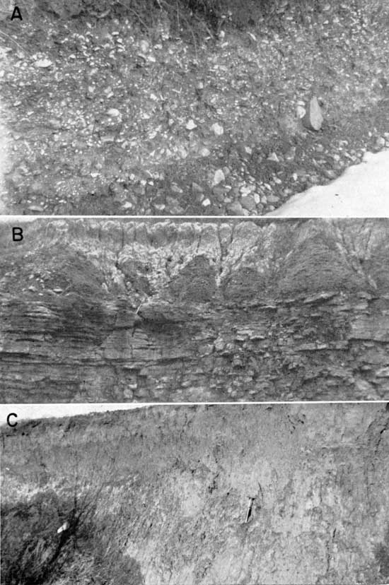
Loess and water-stratified deposits are closely associated with Kansas Till, which contains numerous lenses of fluviatile sand and gravel (Pl. 7A). In many places patches of weathered loess overlie Kansas Till as a black silty clay. No attempt was made to differentiate these deposits, and both are included with Kansas Till in the mapping. The sand and gravel lenses are important because they provide small quantities of ground water from a few shallow wells, but inasmuch as these bodies are small and discontinuous, extensive recharge is impossible, and no large supplies are available. Till itself does not yield water to wells, because the large clay content renders till virtually impermeable.
Plate 7--A. Small lenticular gravel deposit within Kansas Till in road cut 3 feet deep on north bluff of Kansas River valley about 2 1/2 miles north-northeast of De Soto (12-22-11cc). B. Grand Island Member of Meade Group. Note basal gravel and weathered sand above. Overlies limestone strata of Lansing Group. Quarry 1 mile northeast of Eudora (13-21-4aa). C. Sappa Member of Meade Group. Massive red sandy silt characterizes upper portion of Menoken Terrace deposits. About 2 1/2 miles northwest of Eudora (12-21-30bc).
Meade Group
Outwash gravel, sand, and silt deposited by meltwaters from the margin of the stabilized and retreating Kansan glacier are classed as Meade Group (Frye and Leonard, 1952). The Meade Group comprises the extensive Menoken Terrace deposits in the area (Pl. 7B). Upper parts of the Meade Group are mantled with thin and patchy loess deposits, and rain wash has combined with colluvial processes to rework parts of these intensely gullied deposits.
The zone of coarse arkosic gravel and sand, generally less than 10 feet thick, which is commonly found at the base of the Meade, is regarded as the Grand Island Member, although clear differentiation from the overlying sandy silt called the Sappa Member usually is not possible. The coarse constituents of the Grand Island correspond lithologically with material of similar size ranges in Kansas Till, except for a slightly greater proportion of limestone and feldspar. Samples from four test holes drilled through the Meade deposits contained sediments that were all leached and oxidized. Rude stratification and sorting generally distinguish the Grand Island Member from Kansas Till, and a smaller percentage of clay generally is included in the matrix of outwash gravels. The base of the best exposure of the Meade in the area (12-22-21b) is composed of gravels containing 1- or 2-foot lenses of well sorted sand. The basal unit is overlain. by a darkened clay zone containing numerous caliche-like nodules having diameters of about 3 inches. This zone is overlain by several feet of light-brown sandy silt, which becomes more red and less sandy toward the top. The darkened zone probably represents a local area of stagnation in a rapidly aggrading stream valley. This valley was eventually engulfed by the sandy silts of the Sappa Member. The calcareous nodules probably are the result of deposition from ground water.
The Sappa Member is composed of red to light-brown sandy silt (Pl. 7C) overlying sand and gravel of the Grand Island Member where that unit is present. Locally, however, the entire stratigraphic sequence underlying the Menoken Terrace consists of massive sandy silt. More than 80 feet of Sappa silt is present in some parts of the area (12-22-18b,). In weathered outcrops, till and Meade sediments exhibit similar characteristics, both having been altered effectively by intense weathering and colluvial reworking.
The broad flat upland area south of Eudora between Little Wakarusa and Captain Creeks is believed to be a Menoken Terrace deposit. This deposit has been described by Schoewe (1930) and Hoover (1936) as reworked till. The agents that reworked the till are listed as gravity and rain.
The following considerations have led to the conclusion that the upland area south of Eudora is predominantly glacial outwash underlying the Menoken Terrace: (1) the topographic position of the deposit in relation to Menoken Terrace remnants elsewhere, (2) grain size distribution within the deposit, and (3) the permeability of the deposit, as illustrated by the activity of its contained ground water.
The upper surface of the deposit is one of extreme uniformity of elevation, its flatness making it unique along a river valley flanked by rugged bedrock cliffs or by extremely worn remnants of the Menoken Terrace. Appreciable portions of this surface lie at elevations of 890 feet near the south bluff of the Kansas River valley east of Eudora. An almost imperceptible rise brings the highest part of the surface to an elevation of 920 feet at Hesper, more than 3 miles to the south. Thus, the surface of this deposit slopes gently toward the river at less than 10 feet per mile. As there is discontinuous loess deposition not exceeding 5 or 6 feet over much of this surface, the actual terrace summits lie at even lower elevations.
Although the bedrock floor underlying the deposit contains local irregularities, exposures reveal a fairly uniform bedrock surface, which rises from elevations of about 830 feet at the valley bluff to a maximum elevation of 870 feet 4 miles to the south. The Kansas River floodplain lies at an elevation of about 800 feet near Eudora. The bedrock floor underlying the deposit at the southern edge of the mapped area stands about 70 feet higher than that floodplain.
Summits of the dissected Menoken Terrace 2 miles north of Eudora attain elevations of 890 and 900 feet. More than 100 feet of glacial outwash is known to have been deposited in an abandoned valley of Kansan age at the southeastern edge of the mapped area. Therefore, the deposit has a position comparable to other Menoken Terrace deposits in the mapped area.
There is a vertical gradation into finer grain sizes from the base of the deposit toward the top. In a complete section, sand and gravel deposits directly overlie bedrock and grade upward into silty sand, sandy silt, and a loess cap, in that order. Size analyses (Table 2) indicate that the percentage of clay is not appreciably greater than in Menoken Terrace deposits elsewhere. That zones of similar texture persist laterally is illustrated by the fact that coarse sand or gravel was found at nearly every exposure of the bedrock floor underlying the deposit. A random distribution of exposures should not reveal almost unanimous similarity of lithologies at the same stratigraphic position unless lateral uniformity exists.
Table 2--Sediment size analyses of Menoken and Buck Creek Terrace deposits, Kansas Till, and Kansas River alluvium
| Sample | Formation or Group |
Percent in size range | ||||||
|---|---|---|---|---|---|---|---|---|
| >2 mm |
1-2 mm |
0.5-1.0 mm |
0.25-0.5 mm |
0.125-0.25 mm |
0.062-0.125 mm |
<0.062 mm |
||
| 12-20-15dc | Meade | 21.2 | 69.7 | 7.5 | 0.5 | 0.8 | ||
| 12-20-23db | Meade | 1.1 | 45.5 | 49.3 | 2.4 | 0.5 | 1.4 | |
| 13-20-10ac | Meade | 2.4 | 2.9 | 28.3 | 32.2 | 8.6 | 6.6 | 19.4 |
| 12-21-9bd | Sanborn (Buck Creek Terrace deposit) |
7.1 | 21.2 | 15.4 | 15.9 | 40.3 | ||
| 12-21-30ad | Meade | 33.6 | 58.3 | 5.7 | 0.9 | 1.4 | ||
| 12-21-31bb | Kansas River alluvium |
1.4 | 1.4 | 35.9 | 55.5 | 1.8 | 2.0 | 1.9 |
| 12-21-32ad | Kansas River alluvium |
0.7 | 22.8 | 52.3 | 13.4 | 4.4 | ||
| 12-21-33dd | *Meade | 36.8 | 4.3 | 17.4 | 19.6 | 6.9 | 5.0 | 9.9 |
| 13-21-8ba | *Meade | 5.2 | 4.9 | 45.8 | 17.6 | 7.4 | 6.7 | 13.3 |
| 13-21-27aa | *Meade | 18.9 | 36.4 | 19.8 | 6.5 | 19.9 | ||
| 12-22-2da | Meade (Grand Island Mem.) |
43.5 | 12.0 | 26.8 | 7.3 | 4.0 | 2.7 | 3.9 |
| 12-22-15db | Kansas Till | 0.9 | 2.4 | 17.3 | 24.2 | 12.3 | 8.7 | 32.8 |
| 12-22-21bb | Meade (Sappa Mem.) |
0.3 | 1.2 | 1.8 | 40.6 | 55.7 | ||
| *Eudora area | ||||||||
The persistent ground-water discharge from numerous springs and water wells in the area testifies to permeability throughout most of the deposit. This evidence alone precludes the possibility that this deposit is glacial till, because till adversely affects ground-water motion. During the summer and fall of 1952 and the winter of 1953, one of the driest periods in the history of this region, springs issuing from these relatively thin (generally less than 40 feet) Pleistocene deposits never ceased flowing. It is therefore concluded that deposits of the area south of Eudora are glacial outwash of Kansan age, whose upper surface is known as Menoken Terrace.
The sands and gravels of the Meade Group are a potential source of moderate supplies of ground water of very good quality, but the high topographic position of the underlying bedrock floor permits escape of large quantities of water as the discharge of springs. This condition and the small recharge area combine to restrict greatly its water-bearing capabilities. Many dug wells yield small quantities of water of good quality for domestic and stock use. In order to obtain larger supplies, many farmers supplement or replace these shallow water supplies by having deeper wells drilled into underlying Pennsylvanian bedrock.
Sanborn Group
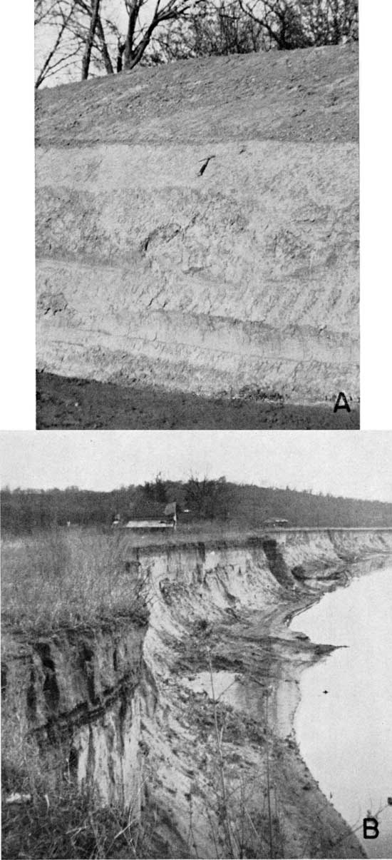
In Kansas the Sanborn Group includes deposits laid down during two glacial ages, Illinoian and Wisconsinan (Frye and Leonard, 1952). Deposits of the Illinoian glacial stage include the Crete and Loveland Formations (Pl. 8A), which underlie remnants of the Buck Creek Terrace in this area. Four feet of silty sand recovered from an auger hole drilled to a depth of 24 feet in a Buck Creek Terrace deposit along Ninemile Creek (12-21-9b) probably represents the Crete Formation, the upper, yellow sandy silt portion of the same deposit is the valley phase of the Loveland Formation. The eolian phase of the Loveland Formation has not been recognized in this area. The characteristic red clayey silt, underlying the exposed section of all Buck Creek Terrace remnants throughout the area, is generally mottled.
Plate 8--A. Red clayey silt of Sanborn Group underlying Buck Creek Terrace in road cut 2 1/2 miles north of Eudora (12-21-20dd). B. Soil profile on intermediate surface complex exposed in recently undercut right bank of Kansas River 2 1/2 miles south of Bonner Springs (12-23-8cb).
Loess deposits of Wisconsinan age are widely distributed over the uplands as thin and discontinuous deposits called the Peoria Formation. Only the "bottomland" of the present Kansas River valley system is completely free of these loess deposits. The Peoria Formation includes both loess and water-laid silt found to be stratigraphically continuous with it (Frye and Leonard, 1952), but the fluvial phase has not been recognized at the surface in this area. It may be included in deeply buried deposits of Wisconsinan age, which form the basal portion of Kansas River valley alluvium.
None of the lithologic units of the Sanborn Group is a favorable aquifer except the Crete (sand and gravel) Formation, found at the base of Buck Creek Terrace deposits in some places. Although a few wells in the area obtain small amounts of water from it, the extremely limited extent of the Crete Formation makes it a very minor source of ground water.
Undifferentiated Wisconsinan and Illinoian Colluvium and Terrace Deposits
Deposits in minor tributary valleys and indistinct terraces along the northern portion of Ninemile Creek have not been differentiated in mapping. The terrace deposits generally consist of clayey silts in their exposed portions, and they are believed to correlate with Buck Creek and Newman Terrace deposits of the main valley. The upper portions of many gullies and valleys of intermittent streams are filled with a sticky red silty clay, which probably is colluvially transported material from the higher Kansas Till and Menoken Terrace deposits. These colluvial deposits were called swales by Hoover (1936).
Wisconsinan and Recent Alluvium
Underlying the Newman Terrace, the intermediate surface complex, and the modern floodplain of the Kansas River valley is a thick fluvial deposit of Wisconsinan and Recent alluvium. The average thickness of the alluvium in the mapped area is 55 feet, and the maximum thickness is 76 feet. Table 3 contains thickness data for different parts of the area.
Table 3--Average thickness of alluvium in Kansas River valley as determinedl by logs of test holes
| Locality | Number of test holes |
Greatest thickness penetrated, feet |
Least thickness penetrated, feet |
Average thickness of alluvium, feet |
|---|---|---|---|---|
| Cross section, 2 miles west of Eudora |
4 | 76 | 46 | 61 |
| De Soto area | 44 | 68 | 38 | 54 |
| Cross section, 1 mile east of Bonner Springs |
10 | 71 | 17 | 51 |
| Total valley area | 58 | 76 | 17 | 54 |
Wisconsinan age is assigned to the coarse, basal portion of the valley alluvium, which was presumably deposited as glacial outwash from the Wisconsinan glaciers. Aggradation has continued to the present, as was demonstrated by slight vertical accretion on the Newman Terrace during the 1951 flood.
Logs of test holes and wells drilled into the alluvium reveal that the basal portion of the alluvium everywhere consists of several feet of sand or gravel. The response of drilling tools in these basal gravels indicates the presence of abundant cobbles and boulders at some localities. Sand, interbedded with lenses of silt and clay, almost everywhere underlies several feet of surficial material composed chiefly of silt.
Logs from four test holes reveal that the silts underlying the Newman Terrace are dark and clayey to depths ranging from 8 to 41 feet. One test hole (11-23-28db) shows 22 feet of dark yellow-gray sandy silt underlying the Newman Terrace. A sandy silt typically underlies the natural levee of the Newman Terrace in the Kansas River valley. U. S. Soil Survey scientists have found that most of the Newman Terrace has a well-developed silty-clay loam typo of terrace soil (Atkinson, personal cominunication).
The intermediate surface complex and modern floodplain generally are underlain by 5 to 10 feet of light-colored sandy silt or silty sand, which grades downward into coarse sand and gravel. In these portions of the valley, dark clayey silt is found only in "clay plugs", channel scars filled with silt by vertical accretion.
The lithologic distinctions of underlying surficial sediments have been used as criteria for distinguishing Newman Terrace from intermediate surfaces in questionable areas. That most of the distinct surface west of De Soto is not a Newman Terrace remnant is demonstrated by the sandy character of the underlying surficial material, as recorded in the logs of all but one of eleven test holes that penetrated this surface. The presence of conspicuous undulations of meander-scroll patterns on this surface also indicates that it is not the Newman Terrace.
Valley alluvium is the only source of abundant supplies of ground water in the area. Alluvium underlying major tributary valleys yields moderate supplies of ground water, but the great extent and saturated thickness of its extremely permeable alluvium make Kansas River valley the only area that can supply ground water in large enough quantities to satisfy existing and potential industrial, municipal, and irrigational demands.
Prev Page--Geomorphology || Next Page--Ground Water
Kansas Geological Survey, Geology
Placed on web March 29, 2012; originally published April 15, 1958.
Comments to webadmin@kgs.ku.edu
The URL for this page is http://www.kgs.ku.edu/Publications/Bulletins/130_1/05_geol.html