![]()
Prev Page--Geography || Next Page--Geology
Geomorphic Development
Pre-Kansan Cenozoic Time
Sedimentation during pre-Kansan Cenozoic time is represented in the area by a few chert gravel deposits lying as isolated remnants high above the modern floodplain of Kansas River. The deposits cap the crests of hills standing higher than adjacent Menoken Terrace remnants of Kansan age. Two areas of high level chert gravels are preserved. Those on the north bluff of the Kansas River valley 3 miles north of Eudora have bedrock floors at elevations of 930 or 940 feet, at least 40 feet above the highest summits of Menoken Terrace remnants to the south. The bedrock floor of remnants south of the Kansas River valley along Kansas Highway 10 at the extreme western portion of the area lies at elevations ranging from 880 to 890 feet, about 35 feet above the surface of a small Menoken Terrace remnant nearby. Test drilling in Kansas River valley 2 miles west of Eudora has revealed the bedrock floor beneath alluvium at an elevation lower than 740 feet (Fig. 2), indicating that Kansas River has incised its valley between 140 and 200 feet since these early valley floors were carved. Colluvial processes have reworked the chert gravel deposits, resulting in gravel. veneers that extend down slopes for many feet below the original bedrock floors. Rude stratification within the gravel veneers is roughly parallel to the slope of the land surface. The high topographic position of these deposits and their almost complete lack of erratic pebbles suggest, but do not prove, a pre-Pleistocene origin.
A low lying deposit of chert gravel along Wakarusa River near Eudora (13-21-7a) is found between Pennsylvanian bedrock and sandy silts identified as glacial outwash of Kansan age. Although it lies at the same stratigraphic and topographic position as basal outwash gravels elsewhere, this chert gravel deposit is inferred to be an early Kansan pro-glacial or pre-Kansan deposit because of the lithologic contrast attested by its lack of erratics.
A high level chert gravel deposit of probable Tertiary age farther upstream near Kiro has been described by Davis and Carlson (1952). Other chert gravels judged to be late Tertiary in age are located at high topographic positions along the Cottonwood-Neosho River valley (Frye and Leonard, 1952).
Kansan Time
The invasion of a continental ice sheet into northeastern Kansas during Kansan time brought to a climax the diverse and profound effects of Pleistocene glaciation in this area. The physical presence of the Kansan glacier, advancing over topography having a less pronounced and widespread drainage system than at present, produced a variety of effects upon the landscape. During glacial advance, pre-existing valleys were scoured deeper, owing to increased water in the streams, and pro-glacial outwash sands and gravels were deposited near the ice margin, only to be overridden during farther advance of the ice sheet (Frye and Leonard, 1952).
Observed glacial striae in this area (Schoewe, 1930) are evidence of glacial scour upon bedrock, although this evidence is not generally seen, because glacial drift and subsequent erosion have obscured or destroyed most of the striae. Glacial scour, however, is evidence that the Kansan glacier crossed the present position of the Kansas River valley during maximum glacial advance (Schoewe, 1930).
When a lobe of the Kansan glacier crossed the position of the Kansas River valley west of Lawrence, meltwaters from the southern edge of the lobe escaped to the east along a temporary spillway in the position of the Wakarusa River valley (Todd, 1911). Most glacial till was deposited during retreat phases of ice-front fluctuation. As much as 40 feet of glacial till is known to mantle crests of hills in this area, and local residents report a maximum of 65 feet of till. Glacial till is found almost exclusively at high topographic positions in this area, because of two factors: (1) post-Kansan erosion has carved valleys deeper, removing much till in the process, and (2) some of the till originally deposited in pre-existing valleys was reworked and redeposited by meltwaters during Kansan time. Areas mantled by Kansas Till generally have a more subdued topography than barren bedrock areas nearby. This distinctive landscape feature results from the less resistant nature of the till and from the downslope action of colluvial processes, which have extended the till over lower bedrock slopes. As the greatest thickness of till is found on the north side of the Kansas River valley, the Kansan glacier was probably stabilized for considerable time at a position just north of the present valley. The bedrock floor underlying 40 feet of till along Kansas Highway 32 about 21/2 miles north of De Soto (12-22-9dc) stands at an approximate elevation of 920 feet. The bedrock floor rises northeastward to an elevation of about 1,000 feet in the vicinity of Kansas Highway 7 at the northeastern corner of the mapped area. In that vicinity the till is much thinner and less extensive.
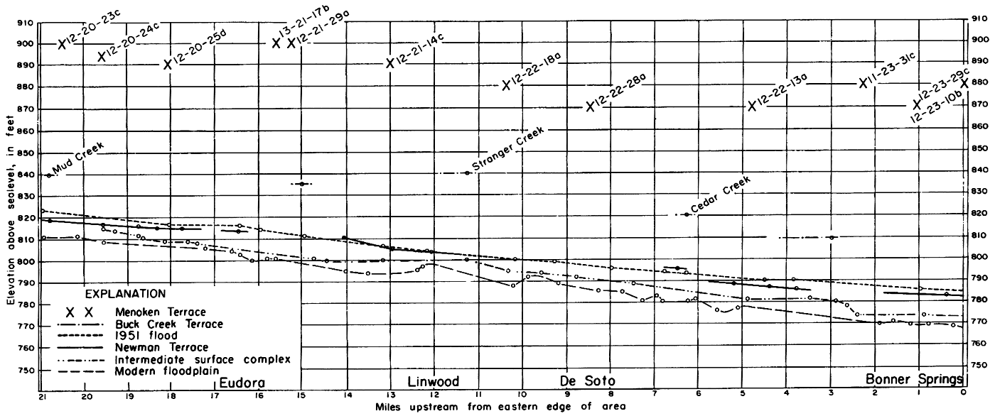
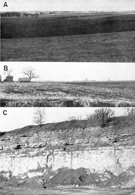
One of the most profound effects of the Kansan glacier was the deposition in pre-existing valley systems of as much as 100 feet of outwash gravel, sand, and silt during glacial retreat, texture of the sediments becoming progessively finer as the glacier receded toward its Canadian center. Dissected remnants of these deposits are preserved as the Menoken Terrace (Davis and Carlson, 1952) in a large portion of this area. Almost continuous remnants form the north bluff of the Kansas River valley from the western border of the area (Pl. 3A) to Bonner Springs, except for a short segment northeast of De Soto. A large area south of Eudora and smaller remnants adjacent to Kansas River near De Soto and along some larger tributary streams are regarded as Menoken Terrace. The precipitous south bluff of the Kansas River valley about 3 miles south of Bonner Springs contains very narrow Menoken Terrace deposits that are too small to be mapped. In the extreme southeastern portion of the mapped area the Menoken Terrace is represented by the dissected surface of an abandoned valley fill. Post-Kansan erosion has destroyed most of the original surface of the Menoken Terrace throughout the mapped area, and an exact accordance of summits is not preserved. Where they are far enough removed from the valley bluff and where they do not occupy divide areas between valleys, the Menoken Terrace summits generally are 80 to 100 feet above the floodplain (Fig. 6).
Plate 3--A. Menoken Terrace scarp along Kansas Highway 32 near west edge of mapped area. Note subdued and dissected form of high-level terrace. B. Buck Creek Terrace along Wolf Creek 3 miles northwest of Bonner Springs. Newman Terrace in foreground constitutes Wolf Creek valley flat. C. Newman Terrace scarp near mouth of Cedar Creek, view looking west. Modern floodplain in right foreground.
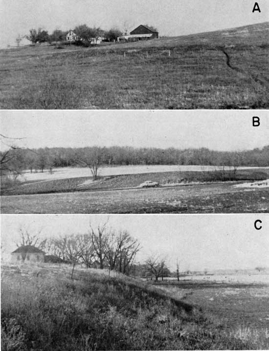
Figure 6--Longitudinal profiles along Kansas River valley between Lawrence and Bonner Springs. A larger version of this image is available.
The bedrock floor of the Menoken Terrace is extremely irregular. At some places bedrock is found at elevations slightly below adjacent floodplain surfaces (12-22-18d), and at others nearby (12-22-18c) it lies more than 20 feet higher. The configuration of the irregular bedrock floor is roughly concave. The concavity of the bedrock floor underlying Menoken Terrace deposits points to the cut-and-fill character of the deposits, because the alluvial veneer of a mature stream undergoing the normal cycle of stream erosion will overlie a flat bedrock floor developed by lateral planation. The irregularity of the bedrock floor emphasizes the limited extent of downcutting in comparison with the tremendous quantities of outwash that subsequently swamped the newly deepened valleys and overflowed to fill even higher areas as well. Extensive gullying of Menoken Terrace deposits reveals small isolated exposures of bedrock at various elevations.
Illinoian Time
Even at its maximum advance, the Illinoian glacier remained farther from northeastern Kansas than any other Pleistocene glaciation and had no direct effect on the area, as outwash or meltwaters never entered the prevailing drainage systems. Indirect effects, however, include a marked cycle of cutting and filling in the valley system of the area. Such effects are mostly a consequence of widespread drainage changes in the Kansas River drainage basin. A comprehensive history of Pleistocene drainage changes in Kansas has been described by Frye and Leonard (1952). Essentially, valley incision in the Kansas River valley during Illinoian time was due to a progressive increase in the size of the drainage basin after retreat of the Kansan glacier from the area. The Flint Hills divide that existed in early Kansan time separated eastward-flowing drainage of the Kansas River system from southward-flowing drainage west of the Flint Hills. This divide migrated toward the west after retreat of the Kansan glacier. As migration proceeded, the Kansas River drainage system captured more and more tributary streams that formerly flowed southward until the size of the drainage basin was increased severalfold. Valley incision along the eastern part of the Kansas River valley resulted.
No test holes were drilled in Illinoian deposits in this area, but a resident whose home is situated on the scarp of an alluvial terrace of Illinoian age reported the nature of the deposits penetrated by a dug well (12-23-7ba). The bedrock floor was deepened by at least 20 feet after Kansan time. This valley subsequently was filled with more than 55 feet of clastic deposits, mostly silt; the surface of the fill is generally 35 feet above the modern floodplain (Fig. 6). Remnants of this surface have been named Buck Creek Terrace (Davis and Carlson, 1952) for a well-developed surface west of Lawrence. The amount of cutting at the type area has been described as 50 to 60 feet below the floor of Menoken Terrace deposits (Davis and Carlson, 1952).
Only a few small dissected remnants of the Buck Creek Terrace are preserved along the Kansas River valley in this area, and most of these are located at the mouths of large tributary streams. Many tributary streams, however, including ephemeral ones, have a distinct terrace 15 to 25 feet above their alluvium (Pl. 3B), and this terrace is regarded as the Buck Creek Terrace in most valleys. Absence of the Buck Creek Terrace along most of the Kansas River valley results because the areal extent of the fill was much smaller than that of the earlier Kansan fill, and a later cycle of cut-and-fill during Wisconsinan to Recent time was almost as extensive as the Kansan. Hence most of the Buck Creek Terrace was destroyed. Along the tributary valleys, cut-and-fill was less severe during this younger episode.
Wisconsinan and Recent Time
Newman Terrace
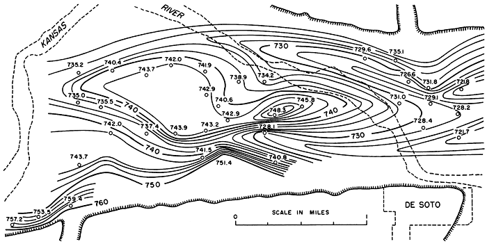
Continental glaciation during Wisconsinan time had a marked, though indirect, effect upon the Kansas River valley. The fluctuating Wisconsinan glaciers did not enter northeastern Kansas, but considerable quantities of meltwater and outwash moved into the nearby Missouri River drainage system. This effected a post-Illinoian downcutting of the bedrock floor of the Kansas River valley, followed by a period of aggradation extending into late Wisconsinan or Recent time. Between Bonner Springs and Lawrence the bedrock floor was deepened to a maximum of 70 feet below the modern floodplain (Fig. 2). The irregular configuration of the bedrock floor near De Soto (Fig. 7) confirms the anticipated form of a valley floor excavated by extremely rapid downcutting in bedrock. The anastomosis of narrow channels is probably the typical expression of such extreme conditions.
Figure 7--Detailed contoured map of bedrock floor underlying alluvium in part of Kansas River valley near De Soto. Contour interval 2 feet. Dashed lines indicate channel of Kansas River in 1950.
The subsequent filling resulted in a surface that is generally 8 to 10 feet above the modern floodplain and is still building up by slight vertical accretion during occasional severe floods. Remnants of this surface, which is discontinuous in this area, have been named the Newman Terrace (Davis and Carlson, 1952) for a widely preserved terrace west of Lawrence.
The Newman Terrace is an essentially flat, featureless surface, which has undergone relatively little gullying or erosion (Pl. 5A). Natural levees have not been well preserved on the Newman Terrace in this area, as most of the terrace has been destroyed, particularly in the central and eastern parts of the valley. The combined valley width is more than 5 miles at the juncture of the Wakarusa and Kansas River valleys. The width of the Kansas River valley progressively diminishes to about 1 mile at the eastern edge of the mapped area, and the Newman Terrace correspondingly decreases in width. The Newman Terrace scarp rarely is well defined except where the terrace has been truncated by the undercut concave bank of Kansas River (Pl. 3C) or a tributary stream and where accretion by tributary streams and slope wash has not added a blanket of sediment that masks the scarp and elevates the original terrace surface. In many places the essentially featureless surface of the Newman Terrace has been modified somewhat by the action of former tributary streams, but these minor irregularities are noticeable only on aerial photographs. Absence of abandoned meander patterns on the Newman Terrace is at least partly the result of the leveling and smoothing action of vertical accretion during Kansas River floods. Most of the Newman Terrace remnants in this area are probably backswamp portions of a former floodplain whose upper surface slopes gently toward the valley bluff.
Intermediate Surface Complex
Sizable remnants of two intermediate surfaces having poorly developed terrace soils and of an extremely youthful floodplain remnant older than the modern active floodplain are found in some parts of the Kansas River valley. This intermediate complex contrasts markedly with the older Newman Terrace in surface configuration and soil development and, to a lesser degree, in elevation. Unfortunately these contrasts are not everywhere conspicuous among the intermediate surfaces themselves, and no attempt has been made to differentiate them in mapping. The transverse topographic profile in Figure 8 shows the configuration of the intermediate surface complex along a north-south traverse about 2 miles west of Eudora. The highest intermediate surface remnant shown on the profile lies at elevations that are at least 3 feet below the adjacent Newman Terrace. A lower intermediate surface remnant lies at elevations that are at least 4 feet below the Newman Terrace. Both of these surfaces have complex meander-scroll patterns, which contrast sharply with the relatively smooth surface of the Newman Terrace, and the meander radii are much shorter than those of younger surfaces (Pl. 4). The older of these intermediate surfaces may correlate with an extensive terrace that Beck (personal communication) has found in the Kansas River valley in the vicinity of Manhattan, Kansas. The lower surface may correlate with a terrace that McCrae (1953) has mapped and has named the Holiday Terrace for a well-defined surface in the Kansas River valley west of Lawrence.Figure 8--Profile across Newman Terrace and intermediate surface complex, 2 1/2 miles west of Eudora. Vertical exaggeration 200 times horizontal. Location of profile is shown on Fig. 3.
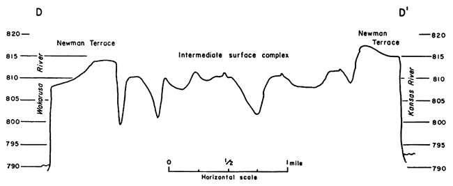
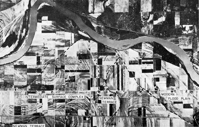
Plate 4--Aerial mosaic of part of Kansas River valley west of Eudora. Note contrasting surface patterns of Newman Terrace, intermediate surface complex, and modern floodplain.
Remnants of intermediate surfaces are found farther downstream (Pl. 8B), and distinct scarps are developed about 2 miles west of De Soto (Pl. 5B) and 2 miles south of Bonner Springs where the modern floodplain truncates the surfaces. Longitudinal profiles (Fig. 6) at these localities show that the intermediate surfaces slope gradually downstream from high upstream areas nearby. Prominent scarps as much as 10 feet high progressively diminish eastward and become barely perceptible less than 2 miles downstream. The longitudinal profile of the modern floodplain exhibits similar characteristics (Fig. 6). The profiles and surface characteristics suggest that much of the surface development since the Newman Terrace began to be dissected has been accomplished by gradual downcutting during the progressive downstream migration of meanders whose radii have constantly expanded. Such a process would be expected to result in surfaces showing considerable longitudinal variation in elevation. The highest points of some areas mapped as intermediate surface complex (such as 12-21-24d, 12-23-8c, and possibly 12-22-24d) may be small, ill-defined remnants of natural levees on the Newman Terrace.
Plate 5--A. Relatively flat, featureless surface of Newman Terrace. View northeast from top of bluff along Kansas Highway 10 at west edge of mapped area. B. Scarp 2 miles west of De Soto. Intermediate surface complex is truncated by modern floodplain. C. Wyandotte Limestone, of Kansas City Group, a bedrock aquifer in some parts of the area. Quarry 1/2 mile east of Bonner Springs (11-23-28cb).
In a recent study of soil profiles in the Kansas River valley between Lawrence and Topeka by members of the U. S. Soil Survey, five surfaces have been differentiated on the basis of soil characteristics. Some of the surfaces have terrace soils in varying degrees of development and can be identified in this manner (C. H. Atkinson, personal communication). Probably a qualified soil scientist could differentiate the intermediate surfaces in the Kansas River valley between Bonner Springs and Lawrence on the basis of soil characteristics.
An extremely youthful floodplain remnant older than the modern active floodplain is preserved west of Eudora (Pl. 4). The irregular topography reflects recently abandoned channel scars of meanders whose radii are intermediate in length between those of older surfaces and the large meanders of the modern floodplain. The meander pattern of this remnant shows that the course of Kansas River was against the south bluff where Wakarusa River now flows. The cause of the seemingly sudden change of course to the north bluff is not certainly known. One possible explanation may be that during some exceptionally large flood, Kansas River found an easier avenue of escape along the course of a hypothetical channel of Mud Creek, which flowed eastward beyond its present mouth.
The abandoned floodplain remnant is extremely youthful, as is attested by the low elevations on its irregular surface (Fig. 8). Although meander scars of the modern floodplain distinctly truncate those of this remnant (Pl. 4), highest accretions on point bars of the abandoned remnant have elevations comparable with those of the modern floodplain. Some of the deeper meander scars (such as those shown in Figure 8) on this remnant still serve as passageways for major flood currents, and scour, rather than deposition, is predominant (Pl. 2). This remnant represents only a local condition along the valley, and no attempt has been made to correlate this unit with any surface downstream.
Modern Floodplain
The modern active floodplain of Kansas River characteristically shows topographic irregularities caused by inequalities of scour and accretion during the migration of the river in its broadly serpentine course from bluff to bluff. Where the valley narrows at Eudora to a width of less than 2 miles, the meander radii are somewhat larger than half the valley width, and the river impinges against the bedrock bluffs. This constriction hinders further growth of meander radii, and each meander tends to retain its shape and size as it migrates slowly downstream. The channel patterns of the migrating meanders of the modern flood-plain are nearly parallel, and the longitudinal profile (Fig. 6) generally indicates a gradual lowering of elevation from one upstream undercut bank to the next downstream. The fact that some of the highest undercut bank portions are preserved remnants of older surfaces (perhaps Newman Terrace in some small areas) suggests three contrasting explanations as to the nature of the downstream movement: (1) Meander migration has been a very slow, progressive process that has not yet had sufficient time to complete its destruction of older and higher surfaces. (2) The actual migration has been rapid, but pulsatory, and frequently interrupted for long periods by certain disturbing factors. These interruptions prolong the preservation of older surfaces. (3) The modern active floodplain is very youthful, and its rapidly migrating meanders will soon destroy all higher and older surfaces.
The 1951 flood reveals examples of rapid downstream migration, as illustrated by certain downstream channel shifts (Pl. 2) of distances nearly as great as the former channel width (12-21-32 and 12-21-26). If such shifts represent typical conditions accompanying severe floods in the Kansas River valley, probably only several thousand years would be required to permit meanders to sweep 1 or 2 miles downstream. Such an advance would easily destroy all intervening remnants of higher and older surfaces.
Complicating factors in the process of progressive sweep render the condition postulated above unusual, rather than typical. The cut-off of meander loops interrupts the process and prolongs the preservation of higher surfaces. Channel changes and erosional effects caused by the 1951 flood in the Eudora "bottom" (Pl. 2) illustrate this disturbing factor. The close alignment of intense undercutting and overbank scour along the north bluff indicates that a cut-off is imminent. As soon as this cut-off is effected during a future flood, the dissection of the higher intermediate surface portion of the meander loop next downstream will be postponed until a future time when another loop has migrated from upstream to the position of the abandoned channel.
The lithology of the undercut bank is another factor that must be considered in the process of sweep. The older intermediate surfaces generally are underlain to depths of 15 feet or more by fine-textured alluvium, whereas the modern floodplain consists of less-resistant sandy sediments, which are undercut much more rapidly. Undercutting of the western portion of Eudora "bottom" during the 1951 flood (Pl. 2) illustrates that the coarse floodplain sediments yielded readily, while the tighter silts of the undercut bank of the Weaver "bottom" acted as a barrier to erosion.
It is concluded that lithologic characteristics and the influence of cut-off meanders play principal roles in the rate of river erosion, particularly in the rate of downstream migration of meander loops. The process of sweep involves many complex interrelationships, and these are only two of many factors that affect the development and destruction of alluvial terraces.
Terrace Development in Tributary Valleys
The largest tributaries in the area are Wakarusa River and Stranger Creek, each of which is about 45 miles long. Other major tributaries are Mud Creek, Ninemile Creek, and Wolf Creek on the north and Captain Creek, Kill Creek, and Cedar Creek on the south. General observations of major tributary streams were made at easily accessible points, and streams whose terrace development is distinct were mapped on aerial photographs. Other deposits along tributaries were mapped as undifferentiated Pleistocene colluvium and terrace deposits. Some general conclusions can be made regarding the geomorphic development of tributary valleys.
The position of the lower reaches of larger southward-flowing tributary valleys has been determined by Kansan cut and fill. This is indicated by the presence of sizable remnants of Menoken Terrace adjacent to the tributary valleys where they approach the Kansas River valley. This is the situation that might be expected if an ice sheet were stabilized for a long period of time not far north of Kansas River. Tremendous quantities of meltwater carved southward-trending passageways to the major trough, and the valleys subsequently were filled with great amounts of outwash. The steep gradient of the bedrock floor underlying Menoken Terrace deposits in Stranger Creek valley suggests that these tributary valleys were short and broad during Kansan time, thus supporting the concept that the Kansas glacier was stabilized near the north bluff.
Most southward-trending tributary valleys underwent moderate incision and deposition during Illinoian time. Small remnants of Buck,Creek Terrace have been identified in many larger valleys, and similar remnants probably exist in most smaller ones. Although small Buck Creek Terrace remnants are found in larger tributary valleys on the south, ephemeral streams near the south bluff generally are short and lack terrace development.
All of the major and many of the smaller tributary valleys were affected by late Wisconsinan to Recent cut-and-fill that produced the Newman Terrace of the Kansas River valley. Stranger Creek, however, removed all traces of the Newman Terrace, except at its mouth, during a later epicycle of erosion. Although the Newman Terrace extends up most tributary valleys, variable amounts of vertical accretion, slope wash, and alluvial fan deposits tend to elevate and mask the original surface. The alluvial floor of tributary valleys conceivably could be mapped as tributary stream alluvium, but this practice would prevent correlation with Pleistocene events recorded in the main valley. Although no test holes were drilled in tributary valley deposits, information obtained by drilling an auger hole and driving a sand point into Newman Terrace deposits of Ninemile Creek valley (12-21-9bd) indicates that as much as 32 feet of late Pleistocene and Recent alluvium fills this valley. The fills of other large tributary valleys probably are of a similar magnitude.
All major tributary valleys except Captain Creek show distinct evidence of a post-Newman epicycle of erosion that has developed surfaces corresponding with the intermediate surface complex of the main valley. With one exception (Wakarusa River) the extent of this surface is directly proportional to the size of the valley; for example, Stranger Creek has meandered profusely at this lower position until almost all the Newman Terrace has been destroyed by lateral planation, whereas the much smaller Ninemile Creek has developed only a narrow strip of the lower surface near its mouth. The perched position of all meander scars on this surface, at heights of 10 to 20 feet above the present channel of Stranger Creek, demonstrates that the surface does not correspond with the modern floodplain of the Kansas River valley. Wakarusa River is nearly as large as Stranger Creek but has developed to only a small extent a surface lower than the Newman Terrace. The conspicuous oxbow south of Kansas Highway 10 west of Eudora is an abandoned channel of the intermediate surface developed by Wakarusa River and is perched above the present stream channel. The surface seemingly narrows upstream, and the Newman Terrace constitutes the valley flat of Wakarusa River.
Channels of all perennial tributary streams in the mapped area are regarded as intrenched into their own alluvium. The surface of the alluvium may represent correlatives of Buck Creek Terrace, Newman Terrace, or the intermediate surface complex. The streams are not meandering at the present time, and they have no surface that correlates with the modern floodplain of Kansas River. Downcutting in the main valley was reflected in the tributary valleys and has continued in them until the present time. The tributary streams can be classed as misfit in their present regimen. The only areas where tributary streams have shown any tendency to meander freely are where their courses cross the modern floodplain of Kansas River. Wakarusa River and Stranger Creek show this characteristic at their mouths.
Effects of 1951 Flood
The 1951 flood was a consequence of the longest period of rainfall on consecutive days and the largest annual precipitation in the officially recorded history of the climate of Kansas. At high-water stages the flood extended from bluff to bluff in Kansas River valley and inundated all late Wisconsinan to, Recent surfaces in the area. In the De Soto area a sizable portion of "bottomland" that had escaped inundation in 1903 was engulfed during the flood crests of 1951. The 1951 flood exceeded the 1903 flood in height, extent, and destruction.
After the 1951 flood most residents of the modern floodplain portion of the Kansas River valley, where the greatest destruction was concentrated, conceded to the powers of nature and abandoned their homes on the floodplain. Deep plowing, under government sponsorship, has restored most of the valley flat to agricultural usefulness. A few tiny patches of extremely thick sand deposits were not plowed and are now incipient sand-dune tracts.
Some questions remain concerning the net flood damage to Kansas River Valley agricultural land. Many valley residents, surveying their own surroundings, tend to overestimate flood damage. Dr. Harold Myers, chairman of the agronomy department at Kansas State College, announced in a Kansas newspaper (1952) that he estimated that 80 to 90 percent of the "bottomland" was either benefited or undamaged as a result of the 1951 flood. This conclusion rises from a belief that the deposition of fine-textured sediments (presumably fine sands And silts) is beneficial to areas originally underlain by coarse material. A visual estimate of areas shown in Plate 2 to be unaffected by harmful sand deposition or by moderate or intense erosion suggests that either Dr. Myers' estimate is overoptimistic or the valley area shown on Plate 2 is not representative of the entire Kansas River valley. The latter is probably correct, as this narrow eastern portion has a much larger proportion of modern floodplain than the broad valley upstream.
A program of detailed mapping of flood deposits was carried out by members of the U. S. Soil. Conservation Service during the winter of 1951 and the spring of 1952. The purpose of the program was to determine the extent of harmful deposition and erosion so that measures could be taken to return the land to productiveness. Deep plowing buried medium and coarse sand deposits, and leveling helped to restore some scoured areas.
A map showing the erosional and depositional effects of the 1951 flood in the vicinity of De Soto and Eudora has been compiled from U. S. Soil Conservation Service data (Pl. 2). Although the data are assumed to be correct, the fact that field parties worked out of three different county offices may have resulted in differences of interpretation. Flood deposits have been differentiated texturally into fine and medium sand size, since fine sands and silts are not regarded by soil experts as detrimental to agricultural land.
The map in Plate 2 shows a distinct correlation between the distribution of flood deposits and the topographic divisions of the valley flat. The Newman Terrace, which generally was covered with about 3 or 4 feet of water during the flood crest (Fig. 6), received almost no deposition. Deposition on the intermediate surface complex was restricted to fine-grained sediments (silt and fine sand) or to negligible amounts of medium sand. The greatest accumulation of flood deposits was concentrated on the modern floodplain, where the thickness of newly deposited sand commonly exceeded 1 foot.
Significant erosional effects of the 1951 flood were restricted to the modern floodplain and parts of the intermediate surface complex. The more prominent scarps of the Newman Terrace underwent moderate scour, but scouring action on the terrace itself was insignificant. Undercutting of banks and intense gullying by overbank scour were most effective on the modern floodplain, although a few scour pits were excavated on the intermediate surface complex. Pronounced meander scars and scarps of the intermediate surface complex were scoured moderately by flood currents. Most exceptions to these broad generalities can be accounted for by such local conditions as valley constriction and conflicting currents.
Prev Page--Geography || Next Page--Geology
Kansas Geological Survey, Geology
Placed on web March 29, 2012; originally published April 15, 1958.
Comments to webadmin@kgs.ku.edu
The URL for this page is http://www.kgs.ku.edu/Publications/Bulletins/130_1/04_geomorph.html