![]()
Prev Page--Contents || Next Page--Geography
Introduction
Purpose and Scope of Report
The purpose of this report is to describe the Quaternary geology and ground-water resources of the Kansas River valley between Bonner Springs and Lawrence, Kansas. Brief consideration is given to Pennsylvanian bedrock, which underlies all Pleistocene deposits within the mapped area, as bedrock formations generally are not good aquifers. The only potential source of abundant ground-water supplies in this area is Kansas River valley alluvium; a ground-water inventory dealing chiefly with the alluvium is presented in this report.
This study supplements the cooperative program of groundwater investigations sponsored by the State Geological Survey of Kansas and the U. S. Geological Survey, in cooperation with the Division of Sanitation of the Kansas State Board of Health and the Division of Water Resources of the Kansas State Board of Agriculture. This report serves to complete a series of ground-water investigations of the Kansas River valley between Kansas City and Topeka, Kansas.
The Kansas River valley between Bonner Springs and Lawrence is principally an agricultural area, but industry is expanding westward from the Kansas City area and is exerting a marked influence in this part of the valley. As industry develops, demands for ground-water supplies will inevitably increase. This study is designed to determine the ground-water conditions and to guide future ground-water development in the area.
Location and Extent of Area
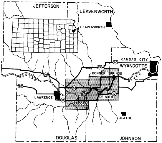
This report covers an area in northeastern Kansas that includes the southern part of Leavenworth County, the southwestern part of Wyandotte County, the northeastern part of Douglas County, and the northwestern part of Johnson County (Fig. 1). Bonner Springs, the largest town within the area, lies about 1 1/2 miles west of the eastern edge of the area. Lawrence is situated nearly 2 1/2 miles west of the area. The area is about 9 miles wide and is roughly bisected by the east-trending Kansas River valley. About a 21-mile length of Kansas River valley (measured along the axis of the valley) is included in the area, which totals 177 square miles.
Figure 1--Index map of Kansas showing location of area discussed.
Previous Investigations
The geology of Wyandotte County was described by Jewett and Newell (1935), and a map showing the distribution of loess of Pleistocene age was included in the report. Newell (1935) described the geology of Johnson and Miami Counties, Kansas. The geology and ground-water resources of Douglas County are being investigated at the present time by Howard O'Conner. Lins (1950) described and mapped the Tonganoxie Sandstone, an important bedrock aquifer that crops out in a large part of the area.
Moore (1936, 1949) described the stratigraphy of Pennsylvanian rocks of Kansas, and the geologic map of Kansas (Moore and Landes, 1937) shows the distribution of Pennsylvanian rocks in the mapped area. Earlier geologic maps of parts of Kansas were published in the geologic atlas of the United States (Hinds and Greene, 1917).
Earliest detailed reports of the Pleistocene geology of this part of northeastern Kansas were those of Todd (1909, 1911, 1923), which described the drainage and geologic history of the glaciated portion of northeastern Kansas. He placed the southern limit of the drift border at a position north of Kansas River valley. Schoewe (1930, 1949) demonstrated, through the recognition of glacial till deposits, that the southern limit of glaciation should be extended to a position several miles south of the Kansas River valley. At Schoewe's suggestion Hoover (1936) made a petrographic study of lithologic samples from scattered Pleistocene deposits along Kansas River between Kansas City and Manhattan. He described terrace, till, and colluvial deposits of Pleistocene age. A subsurface reconnaissance of glacial deposits in northeastern Kansas was made by Frye and Walters (1950), but it included no direct study of the area discussed in this report. The Pleistocene geology and ground-water resources of the Kansas River valley between Lawrence and Topeka were studied in detail by Davis and Carlson (1952). Frye and Leonard (1952) described the Pleistocene geology of Kansas and summarized the existing knowledge in one publication.
The Emergency Relief Committee and the Works Progress Administration carried on ground-water investigations in eastern Kansas in 1934 and 1936 respectively, and community wells that were constructed by those organizations are still used during periods of drought. Moore (1940) summarized the ground-water resources of Kansas. Detailed ground-water investigations have been carried out in the vicinity of Lawrence by Lohman (1941) and in the Kansas River valley between Kansas City and Bonner Springs by Fishel (1948).
Methods of Investigation
The investigation upon which this report is based began in April 1952 when test holes were drilled in the area. Most of the area was mapped in the field during two months of the summer of 1952. In April and May 1952 two observation wells were established in the area; 39 measurements of the depth to water in these wells were made during the subsequent 9 months.
The geology was mapped in the field at scales of about 2.65 and 3.15 inches to the mile on U. S. Geological Survey topographic maps and aerial photographs supplied by the State Geological Survey of Kansas, and the areal geology is shown on the map in Plate 1. The base map of the area used in Plates 1 and 2 was compiled from 7 1/2-minute quadrangles of the U. S. Geological Survey.
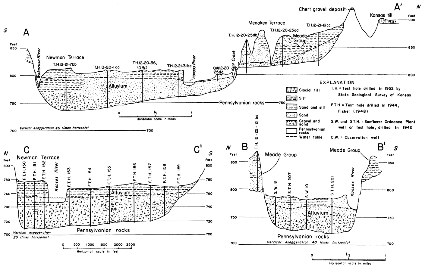
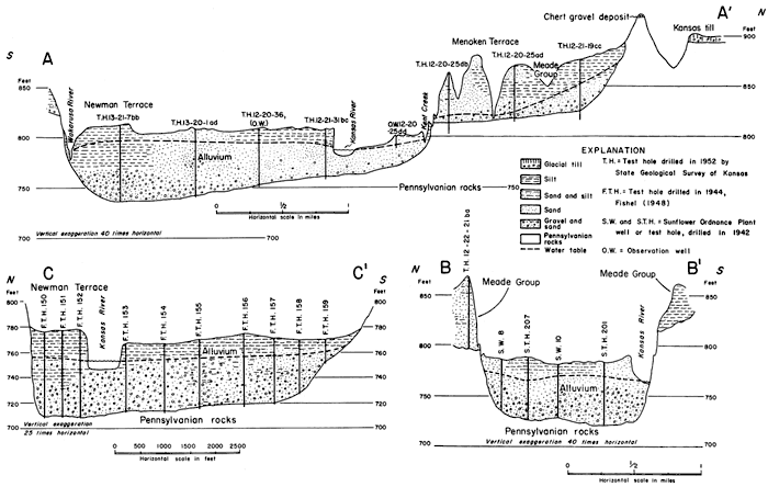
Nine test holes were drilled in the area by William Conner and Samuel Bishop, using the portable hydraulic rotary drilling rig owned by the State Geological. Survey of Kansas. Lithologic samples were collected from these holes, and logs were prepared in the field by me. Three geologic cross sections (Fig. 2) were compiled from information obtained from sample logs of these test holes, drillers logs of test holes drilled for Sunflower Ordnance Plant at De Soto, and logs of test holes published by Fishel (1948).
Figure 2--Geologic sections across Kansas River valley between Lawrence and Bonner Springs. Location of sections shown on Fig. 3. A larger version of this image is available.
Field work included drilling more than 70 auger holes to depths ranging from 2 to 28 feet to collect lithologic samples, to determine the thickness of deposits, to determine the depth to the water table, or to supplement meager outcrop information. Well owners were interviewed regarding the nature and thickness of water-bearing formations, and available logs were obtained. Depths to water level were measured in 30 wells and 4 auger holes, samples of water were collected from 14 wells and 1 spring, altitudes of the water table were surveyed at 3 scour pits, and altitudes of the water surface of streams were determined at 10 localities. Altitudes of the measuring points of wells penetrating valley alluvium and of the land surface at the sites of four auger holes and nine test holes were surveyed from benchmarks of the U. S. Coast and Geodetic Survey, by plane table and telescopic alidade. Altitudes of the measuring points of upland wells were estimated by hand level and U. S. Geological Survey topographic maps. The locations of wells and test holes, altitudes of points on the water table, depths to the water table, and generalized ground-water contours are shown in Figure 3.
Figure 3--Map showing generalized contours on water table and locations of water wells and test holes. A larger version of this image is available.
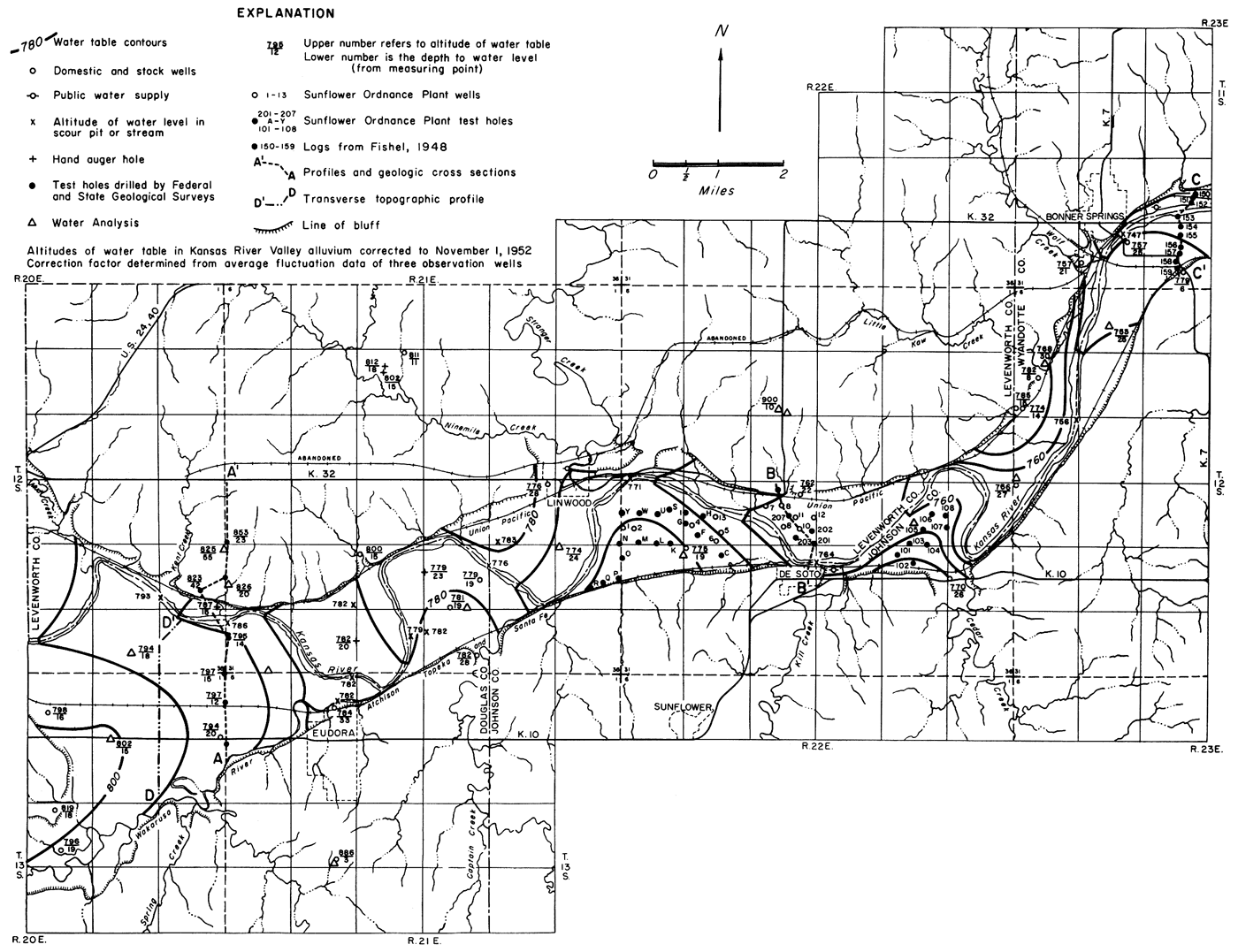

Size analyses of selected lithologic samples are tabulated in Table 2. Lithologic samples from nine test holes and many auger holes were examined under the binocular microscope. Information included with logs of Sunflower Ordnance Plant test holes made possible the preparation of detailed contour maps of the bedrock floor and the 1942 water table in a part of the Kansas River valley near De Soto. These maps are shown in Figures 7 and 9 respectively. The altitude of the surface of the ground, the depths to the water table, and the depths to bedrock were given for most test holes, as determined by well drillers; the accuracy of the maps depends upon the reliability of that information.
Location and Well-numbering System
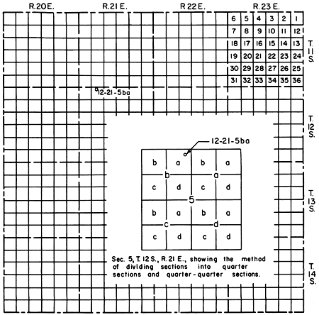
The locations of wells, test holes, and auger holes, and of many localized features described in the text are designated according to General Land Office surveys in the following manner. The first three numbers refer to the township, range, and section in that order. Two lower-case letters follow, which represent the 160-acre tract within the section, and the 40-acre tract within the quarter section, respectively. The lower case letters representing the 160-acre and 40-acre tract are a, b, c, or d, beginning in the northeast quarter. The others are placed consecutively in the other quarters in a counter-clockwise direction. If two or more wells or test holes are located within a 40-acre tract, the letters are followed by numbers indicating the order in which the wells or test holes were inventoried or drilled, as the case may be. Figure 4 illustrates the relationship described.
Figure 4--Map illustrating well-numbering system used in this report.
Acknowledgments
Appreciation is expressed to the residents and municipal officials of the area who so, kindly supplied information and rendered assistance during the course of the field work. Three residents graciously allowed test holes to be drilled on their properties. Acknowledgment is made of the friendly cooperation shown by personnel of Sunflower Ordnance Plant, U. S. Soil Conservation Service county offices in Leavenworth, Johnson, and Douglas Counties, U. S. Army Corps of Engineers in Kansas City, and Water Resources Division of the U. S. Geological Survey in Topeka in making available much important information included in this report. Mr. C. H. Atkinson and other soil scientists affiliated with the U. S. Soil Survey office at Kansas State College spent a day in the field with me disclosing soil characteristics that are found in the Kansas River valley.
Appreciation is expressed for the unselfish efforts of Samuel Bishop and John Atchley in helping to set up an observation well and in assisting in surveying.
Prev Page--Contents || Next Page--Geography
Kansas Geological Survey, Geology
Placed on web March 29, 2012; originally published April 15, 1958.
Comments to webadmin@kgs.ku.edu
The URL for this page is http://www.kgs.ku.edu/Publications/Bulletins/130_1/02_intro.html