![]()
Prev Page--Introduction || Next Page--Geomorphology
Geography
Topography
The Kansas River valley between Bonner Springs and Lawrence lies at the border between the Dissected Till Plain and the Osage Plains. These are divisions of the Central Lowlands physiographic province of the Interior Plains as defined by Fenneman (1931). Schoewe (1949) places the area entirely within the Dissected Till Plain, which he further subdivides into two units: the Attenuated Drift Border, which includes most of the mapped area, and the Kansas Drift Plains, comprising small portions of the uplands north of the valley.
The physical setting of the area consists of three gross features: (1) bedrock uplands, (2) high-level alluvial terrace remnants, and (3) the valley system or lowlands containing broad flat alluvial floors. The bedrock uplands in the eastern portion of the area are characterized by prominent east-facing escarpments of resistant limestone formations, which strike northeast and dip gently to the northwest away from the Ozark Uplift. The bedrock uplands in the western portion of the area are more subdued, as they are underlain generally by less resistant sandstone, siltstone, and shale formations. A mantle of glacial till covering much of the uplands tends to mask the irregularities produced by differential erosion of the bedrock.
Dissected alluvial terrace remnants border most of the Kansas River valley. Although the summits of many of these remnants rise 80 to 100 feet above the floodplain, the ill-defined and gently sloping terrace scarps contrast strongly with the precipitous limestone cliffs that form the valley bluff in much of the eastern portion of the area. In some western parts of the area high-level terraces constitute upland interfluves between tributary valleys.
The east-trending Kansas River valley is a conspicuous flat lowland area whose flat-bottomed tributary valleys resemble the major valley on a small scale. Dissection of the Kansas River valley has not been uniform, the western part having been carved in less resistant formations than the eastern part. The Kansas River valley can be divided topographically into a low flat terrace and an irregularly scarred modern floodplain. Another division, not always clearly discernible topographically, lies between the terrace and floodplain. It is an intermediate surface complex containing many surface irregularities and minor scarps. The modern active floodplain is predominant in the narrow parts of the valley, and the terrace is more widely represented in the broad western portion of the valley. Although the terrace is well drained, numerous undrained marshes and ponds fill old meander scars on the floodplain and intermediate surface complex.
The local relief along Kansas River ranges from about 100 feet near the western border to about 250 feet at the eastern border of the area. The high escarpment in the northwestern corner of the area has elevations exceeding 1,080 feet, whereas the channel of Kansas River lies at an elevation of about 750 feet in the eastern extremity of the mapped area. The total relief of the mapped area, therefore, is slightly more than 330 feet.
Climate
The Kansas River valley between Bonner Springs and Lawrence has a humid continental climate. A long growing season is endowed with abundant rainfall and high temperatures. The average length of the growing season is 194 days; it normally begins about April 11, the average date of the last killing frost in the spring, and ends about October 22, the average date of the first killing frost in the fall.
The normal annual precipitation at Bonner Springs is 36.04 inches. Figure 5 shows the normal monthly distribution of rainfall at Bonner Springs. Table 1 lists the monthly precipitation at Bonner Springs for the years 1951 and 1952. Abnormal conditions prevailed in both years; the area received about 50 inches of precipitation in 1951, the year of the disastrous Kansas River flood, and less than 27 inches the following year. The mean annual temperature at Lawrence is about 55° F. July and August are the warmest months, having normal monthly temperatures of 79.1° and 77.5° F, respectively, and January is usually the coldest month, having an average temperature of 29.9° F. Daily temperatures rarely exceed 100° F or drop below 0° F for several consecutive days.
Figure 5--Chart of normal monthly precipitation at Bonner Springs.
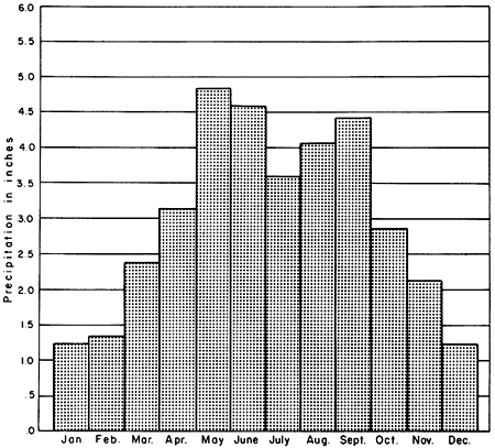
Table 1--Monthly precipitation for 1951 and 1952 at Bonner Springs, Kansas
| Month | Precipitation in 1951, inches |
Precipitation in 1952, inches |
|---|---|---|
| January | 0.66 | 0.48 |
| February | 1.72 | 1.48 |
| March | 2.45 | |
| April | 2.89 | 4.09 |
| May | 5.11 | 3.16 |
| June | 9.17 | 2.52 |
| July | 8.94 | 3.13 |
| August | 6.03 | 5.60 |
| September | 6.40 | 1.59 |
| October | 4.32 | 0.00 |
| November | 1.18 | 1.98 |
| December | 0.65 | 1.28 |
| Annual | 49.52 |
Population
The largest town in the area is Bonner Springs, which has a population of 2,241 [6,768 in 2000, from KU Institute for Policy & Social Research]. The population of the other three towns as recorded by the 1950 census are: Eudora, 929 [4,307 in 2000]; De Soto, 532 [4,561 in 2000]; and Linwood, 238 [374 in 2000]. The total population, exclusive of the above towns, of the seven townships of which portions are included in the mapped area is 12,699. Inasmuch as only small portions of these townships are included in the area, the combined rural and town population of the mapped area is estimated to be fewer than 7,000. This estimate excludes Sunflower Village, for which no population figures are available.
Transportation
The area is served by three state highways; Kansas Highways 32 and 10 roughly parallel Kansas River on the north and south upland respectively, and Kansas Highway 7 crosses Kansas River at Bonner Springs and constitutes much of the east border of the mapped area. U. S. Highways 24 and 40 are merged in their traverse across the northwestern portion of the area. Much of the area is served by well-graded section roads, and little difficulty is encountered in traveling anywhere within the mapped area when the roads are dry.
Main lines of the Union Pacific and the Atchison, Topeka and Santa Fe Railways traverse the area along the foot of the north and south bluff respectively of the Kansas River valley. Branch lines of both railroads cross the area north of Kansas River.
Agriculture
Corn, wheat, and hay are the principal crops raised in the area. Other important crops include potatoes, soybeans, sorghum, and barley. Apples, peaches, grapes, and pears constitute most of the fruit production. Douglas County leads the other counties represented in the area for the value of its crops and fruits. Livestock and poultry production are important in the uplands, particularly where farms are located on steep bedrock slopes. Irrigation has not been carried on extensively in the area, but the drought that has prevailed since 1952 has stimulated an interest in irrigation.
Industry
The only town in the area that has significant industrial development is Bonner Springs; here cement, mill machinery, cereal, and canned goods are manufactured. The largest industry in the area is the Sunflower Ordnance Plant near De Soto operated by Hercules Powder Company for the United States government. Most of the plant is located south of Sunflower outside of the mapped area, but a water-intake plant and 12 water wells supply water to the chemical plant from their sites in the Kansas River valley flat near De Soto. The accessibility of abundant ground-water resources was of primary importance in the establishment of the plant at its present location.
Prev Page--Introduction || Next Page--Geomorphology
Kansas Geological Survey, Geology
Placed on web March 29, 2012; originally published April 15, 1958.
Comments to webadmin@kgs.ku.edu
The URL for this page is http://www.kgs.ku.edu/Publications/Bulletins/130_1/03_geog.html