![]()
Prev Page--Stratigraphy--Pennsylvanian || Next Page--Stratigraphy--Cretaceous to Quaternary
Stratigraphy, continued
Rocks of Permian Age
The Permian rocks of Kansas are divided into the following series listed in descending order: Guadalupian, Leonardian, and Wolfcampian.
Permian rocks are separated from the Pennsylvanian by a low angular unconformity and an erosional surface of high relief in some areas. They are separated from the overlying Cretaceous by an angular unconformity representing a long hiatus, during which hundreds of feet of Permian rocks were eroded.
Wolfcampian Series
The Wolfcampian Series is divided into the following groups listed in descending sequence: Chase, Council Grove, and Admire.Admire Group
The formations of the Admire group, listed in descending order in Table 14, have been differentiated in outcrops in eastern Kansas. The thicknesses at outcrops in eastern Kansas are reported by Moore and others (1944, 1951); those in southeastern Nebraska by Condra and Reed (1943, p. 36-37).
Table 14--Sequence and thickness of formations of the Admire group
| Range of thickness in Kansas outcrops, feet |
Average thickness in Kansas outcrops, feet |
Range of thickness in southeastern Nebraska, feet |
||
|---|---|---|---|---|
| Admire group | ||||
| Hamlin shale | 50 | 50 | 48-50 | |
| Five Point limestone | 1-5 | 3 | 1-5 | |
| West Branch shale | 10-30 | 20 | 30 | |
| Falls City limestone | 3-10 | 7 | 9 | |
| Hawxby shale | 12-40 | 30 | 10-12 | |
| Aspinwall limestone | 1-8 | 5 | 1-3 | |
| Towle shale | 15-135 | 30 | 10-50 | |
| Total | 145 | Aver. 134 | ||
The Admire group, exclusive of the basal sandstone, consists dominantly of shale, some of which is sandy. The limestone beds, although persistent, are thin and lack unique lithologic features that might identify them in the subsurface.
The Towle shale includes the Indian Cave sandstone member, which fills deep channels cut in the surface of the Pennsylvanian rocks during the hiatus between deposition of the Wabaunsee and Admire groups. Channels filled with Indian Cave sandstone 120 feet thick are exposed in outcrops. The sandstone is reported (Harned and Chelikowsky, 1945) to be in contact with the Auburn shale below the Reading limestone in Pottawatomie County, which fact would indicate a local depth of erosion of about 250 feet. In the subsurface the details of topography of the pre-Permian surface are not clearly revealed and give the impression of a surface only slightly dissected. Except in steep-sided channels filled with sand the basal beds of the Towle consist mainly of sandy or silty shale.
The Aspinwall limestone is the first persistent limestone above the base of the Admire. On account of the unconformity at the base of the Admire, the thickness of the Permian below the Aspinwall varies greatly. Comparison of the sequence from the Aspinwall to datum beds such as the Dover and Tarkio limestones, in the Wabaunsee below the unconformity, reveals a decrease in thickness toward the west or northwest. The regular thinning of this succession is the basis for the conclusion that regional deformation continued during the hiatus, in the same general pattern as during Pennsylvanian time, when the area was tilted by differential movements toward the southeast.
The Falls City and Five Point limestones, together with a lenticular limestone locally recognized in the intervening West Branch shale, appear in logs of wells in the Salina basin as a limestone sequence in which the shale partings are generally determinable only in electric logs.
That part of the Admire group above the Aspinwall limestone averages about 115 feet in thickness in outcrops in eastern Kansas, about 100 feet in southeastern Nebraska, and 90 feet in the Salina basin and on the Central Kansas uplift.
Council Grove Group
The formations of the Council Grove group, listed in descending order in Table 15, have been differentiated in outcrops in Kansas. The thicknesses at outcrops in Kansas are from Moore, Frye, and Jewett (1944, p. 165-168). Those for Nebraska are from Condra and Reed (1943, p. 33-36) .
Table 15--Sequence and thickness of formations of the Council Grove group
| Range of thickness in Kansas outcrops, feet |
Average thickness in Kansas outcrops, feet |
Range of thickness in southeastern Nebraska, feet |
||
|---|---|---|---|---|
| Council Grove group | ||||
| Speiser shale | 18-35 | 25 | 19 | |
| Funston limestone | 5-11 | 8 | 8 | |
| Blue Rapids shale | 16-25 | 20 | 22 | |
| Crouse limestone | 10-13 | 12 | 11 | |
| Easly Creek shale | 15 | 15 | 14 | |
| Bader limestone | 18-25 | 23 | 24 | |
| Stearns shale | 8-20 | 14 | 17 | |
| Beattie limestone | 15-20 | 18 | 18 | |
| Eskridge shale | 37 | 37 | 50 | |
| Grenola limestone | 38 | 38 | 33 | |
| Roca shale | 20 | 20 | 23 | |
| Red Eagle limestone | 18-20 | 19 | 11 | |
| Johnson shale | 16-25 | 20 | 19 | |
| Foraker limestone | 50 | 50 | 46 | |
| Total | 319 | 315 | ||
The alternation of well-defined limestones and shales of the Council Grove group is in sharp contrast to that of thin limestones and dominant shales of the Admire group. The group consists of equal proportions of shale, a large part of which is red, and of limestone, much of which is impure and shaly. There is seldom any doubt as to the identity and position of the Foraker and Grenola limestones or the Eskridge and Speiser shales. The limits of some of the intervening beds are obscure, partly because some of the limestones are soft and argillaceous and some of the shales are calcareous, and partly because such formations as the Funston, Crouse, Bader, and Beattie limestones consist of relatively thin limestone beds interstratified with shale members, The formations are more clearly identified in electric logs than in samples.
The Foraker limestone, at the base of the Council Grove group, consists of two more or less prominent limestone members separated by a calcareous shale containing fusulines in such abundance as to distinguish the Foraker from other formations, in which fusulines are less conspicuous. In electric logs the upper member is more prominent. The Foraker becomes more calcareous southward, and in the outcrops in southern Kansas and Oklahoma the middle shale member also becomes limestone. This formation contrasts with the limestones of the Pennsylvanian, most of which become argillaceous or interfinger with shale toward the south.
The Red Eagle limestone, like the Foraker, consists of upper and lower limestone members separated by a shale member and, like the Foraker, becomes a single limestone ledge in the outcrops in southern Kansas. In the outcrops it thins slightly toward the north. Although the Red Eagle is recognized in the subsurface, its limits are generally not clearly defined in sample logs, although well marked in electric logs.
The Grenola limestone can be identified in most sample logs. The upper member, the Neva limestone, is clearly defined, but the lower member, the Burr limestone, which is interstratified with shale, is obscure.
The Eskridge consists mainly of red shale, although it includes some gray shale. In some localities in the subsurface the shale is interstratified with calcareous beds. The Eskridge is consistently reported in all drillers logs and is easily recognized in sample logs. It is the most reliable datum bed in the lower Permian despite the fact that the Roca, Stearns, Easly Creek, and Speiser shales also include red shale. N one of these shales is so consistently thick or so consistently red as the Eskridge. The Eskridge displays a characteristic pattern in electric logs,
The Beattie and Bader limestones, as represented in drillers logs, sample logs, and electric logs, are indistinct in many wells, probably because these formations and the intervening Stearns shale contain as much shale and impure limestone as pure limestone. However, the Cottonwood limestone, which includes numerous slender fusulines, overlies the Eskridge shale and is nearly always manifest.
The Easly Creek shale consists mainly of red and gray shale. It includes some gypsum near the base. This is the first appearance in the Permian of evaporites, which constitute a large proportion of the deposits of the upper part of the Permian.
Neither the Crouse limestone nor the Funston limestone is consistently recognized in sample logs, probably because they include much impure limestone and calcareous shale, but they are recognizable in most electric logs.
The Speiser shale consists of shale and thin beds of limestone. The lower part includes much red shale, It is generally revealed in logs as a red shale below the conspicuously cherty Wreford limestone of the Chase group.
The thickness of the Council Grove group is singularly constant. It averages about 319 feet in the outcrops in eastern Kansas and 315 feet in southeastern Nebraska. It is 290 feet in wells just west of the Nemaha anticline, 310 to 320 feet in the Salina basin, and 320 feet on the Central Kansas uplift, in T. 7 S., R. 20 W.
Chase Group
The formations of the Chase group, listed in descending order in Table 16, have been differentiated in outcrops in Kansas. The thicknesses of these formations at the outcrops are reported by Moore and others (1944, 1951). Those in Nebraska are reported by Condra and Reed (1943).
Table 16--Sequence and thickness of formations of the Chase group
| Range of thickness in Kansas outcrops, feet |
Average thickness in Kansas outcrops, feet |
Range of thickness in southeastern Nebraska, feet |
||
|---|---|---|---|---|
| Chase group | ||||
| Nolans limestone | 22-40 | 34 | 28 | |
| Odell shale | 20-40 | 30 | 34 | |
| Winfield limestone | 28 | 28 | 21 | |
| Doyle shale | 80 | 80 | 59 | |
| Barneston limestone | 80-90 | 84 | 60 | |
| Matfield shale | 60-90 | 78 | 62 | |
| Wreford limestone | 30-40 | 35 | 30 | |
| Total | 369 | 294 | ||
The Chase group consists of a sequence of alternating beds of thick limestone and shale. The limestones constitute approximately 50 percent of this group in outcrops. Northward into southeastern Nebraska the proportion of shale and limestone remains approximately the same, although both limestones and shales become thinner.
All the limestone formations of the Chase are cherty, especially the Wreford and the Florence limestone member at the base of the Barneston.
The Wreford limestone consists of two limestone beds separated by a shale bed. Because both limestone beds are consistently cherty in outcrops and in the subsurface, the Wreford is an excellent datum bed, although the formation is not everywhere conspicuous in electric logs.
The Matfield shale is varicolored, It includes the Kinney limestone member consisting of interstratified shale and thin limestone beds commonly represented only in electric logs.
The Barneston limestone includes the Florence limestone member at the base and the Fort Riley limestone member at the top separated by a thin gray calcareous shale member. The Florence limestone member is conspicuously cherty both at outcrops and in the subsurface. Careful search of samples from the Fort Riley or the Florence member almost always reveals fusulines, many of which in the Florence member are silicified. The Fort Riley limestone is non cherty and contains the youngest fusulines known in Kansas. The two conspicuously cherty beds, the Florence and the Wreford, are valuable markers in a sequence of limestone and shales whose identification might otherwise remain obscure. In electric logs the Barneston displays a characteristic pattern. For this reason its base has been used as a datum in drawing thickness maps; its top and the Nolans and Winfield are obscure in some areas, The expression of the Barneston in electric logs from wells on parts of the Central Kansas uplift is weak.
The Doyle shale is variegated and in part calcareous. The Towanda limestone member of the Doyle occurs 20 to 30 feet above its base. Fossils are rare in the outcrops, In the subsurface toward the northwest the Towanda becomes dolomitic and in Phillips County consists entirely of anhydrite.
The Winfield limestone in outcrops in northern Kansas consists of upper and lower limestone members separated by shale. Toward the northwest it becomes dolomitic, The lower member of the Winfield is cherty in outcrops, but chert is not present in all wells in the subsurface.
The Odell shale, like the other shales of the Chase group, is variegated, red predominating.
The Nolans limestone consists of two thin limestone beds at the base, generally recognized only in electric logs, and the more prominent and thicker Herington limestone at the top. The intervening shale member is calcareous and includes some limestone in outcrops in southern Kansas. The Nolans limestones thicken toward the northwest and grade into dolomite.
The limestones and shales of the Chase group seem to be somewhat more variable in thickness in the subsurface, as represented in well logs, than in outcrops. This is probably due more to imperfections in the logs and samples than to sharp fluctuations in the thickness of the formations, although these also may occur. Red shales are not uncommon in the upper Pennsylvanian, but they are increasingly prominent in the Council Grove group and make up a still larger proportion of the shales of the Chase group. Toward the northwest the limestones above the Barneston grade into dolomite, and some anhydrite begins to appear with the dolomite.
The total of the average thicknesses of formations in the Chase group in outcrops in Kansas is 369 feet. The average thickness of the Chase in southeastern Nebraska is 294 feet. The overall thickness of the Chase in northern McPherson County is 360 feet. In the Salina basin the Chase is 250 feet thick and on the crest of the Central Kansas uplift it is 240 feet thick. The Chase group thins toward the northwest in the familiar pattern of the Pennsylvanian and older Permian groups. There seems to have been little or no accentuation of the Salina basin or Central Kansas uplift in Chase time. The southward increase in limestone components contrasts with the tendency toward increase in shale in the older rocks.
Leonardian Series
The Leonardian Series is divided into the Nippewalla group above and the Sumner group below.
Sumner Group
The following formations of the Sumner group, listed in descending order, have been differentiated by the Kansas Geological Survey in outcrops in east-central Kansas (Moore and others, 1944, 1951): Stone Corral dolomite, Ninnescah shale, and Wellington formation.
Other groupings of these rocks have been made. Norton (1939) placed the Ninnescah and Stone Corral at the base of the redbed sequence of the "Cimarron Series" described by Cragin (1896). The base of the Wellington was at one time placed at the Hollenberg limestone member of the Wellington, about 50 feet above the Herington limestone member of the Nolans limestone, which is now listed as the uppermost formation of the Chase group.
The Sumner group comprises a sequence of beds of evaporite and shale containing a few local, more or less discontinuous thin limestone beds of variable character. The upper part consists mainly of shale, and the lower part in central Kansas consists chiefly of shale, anhydrite, and salt.
Wellington formation--A detailed study of the outcrops of the Wellington formation in south-central Kansas was made by Ver Wiebe (1937), who traced several beds of limestone in the outcrops. The Hollenberg is the only one of these limestones recognized with confidence in the subsurface of the Salina basin, but others may be present. In the subsurface, Ver Wiebe distinguished five zones, based on lithologic changes, which he correlated with the outcrops. These five zones in descending order are: "upper gray beds", "red beds", "middle gray beds", "salt beds", and "anhydrite beds". These zones are all recognizable in the subsurface in the Salina basin.
The accurate separation of these units is rendered difficult by the transitional contacts between some of the units. The base of the Wellington at the top of the Nolans limestone is a definite datum, but the contact of the anhydrite beds with the overlying salt beds is transitional. The contact of the "salt beds" with the "middle gray beds", which, like the salt bed, include much anhydrite, is also transitional. Even the color distinctions of the three upper units are elusive because over broad areas toward the west some of the "middle gray beds" seem to grade into the increasingly thick "red beds" zone.
Thick beds of salt in the Hutchinson salt member are revealed by gamma ray logs and inferentially by comparison in electric logs. It is probable that mixtures of salt and anhydrite as well as alternating thin beds of salt and anhydrite are expressed as anhydrite in electric logs. The contact of the "upper gray beds" of the Wellington with the red shales of the Ninnescah is abrupt and definite in sample logs but is not apparent in electric logs.
It is convenient to divide the Wellington formation into three members: The "anhydrite beds" of Ver Wiebe at the bottom, the "salt beds" or Hutchinson salt member in the middle, and an unnamed member at the top comprising the "middle gray beds", "red beds", and "upper gray beds" of Ver Wiebe's classification,
The "anhydrite beds" at the base of the Wellington (known also as the Pearl shale) consist of a sequence of gray shale alternating with anhydrite beds. In the Salina basin it includes the Hollenberg limestone member, 20 to 40 feet above the base, and the overlying beds of shale and anhydrite 130 to 150 feet thick. Toward the west anhydrite predominates. The Hollenberg limestone of the central area of the Salina basin becomes irregularly dolomitic toward the west and probably grades northwestward into one of the anhydrite beds of this zone. Some varicolored shale occurs in this zone below the Hollenberg.
The Hutchinson salt member, the "salt beds" of Ver Wiebe, is an evaporite zone consisting of salt (halite) interstratified with beds and laminae of anhydrite and probably coprecipitated mixtures of both. The salt beds are thickest in Russell, Ellsworth, Rice, and Reno counties, and they thin somewhat irregularly toward the margin of the basin where, together with the anhydrite, they interfinger with shale washed into the basin from the low border areas. The "salt zone" becomes thinner in southern Kansas and extends into northern Oklahoma. It should normally crop out in a belt trending south from Osage and Saline counties, but the salt and most of the associated anhydrite beds have been dissolved by surface waters for a distance of 20 to 30 miles down dip, In the areas of outcrops, the removal of the salt has allowed the overlying cover of insoluble rocks to slump in a zone of irregular dips and confused bedding.
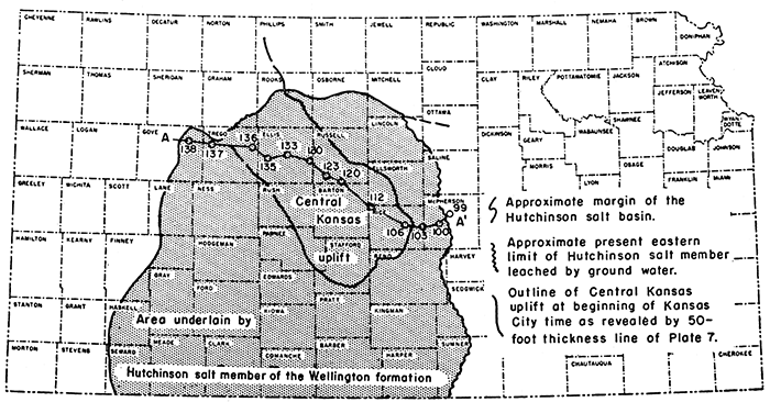
Figure 15 shows the approximate limits of the salt basin, after Bass (1926), modified by the addition of more recent data from Norton (1939), the Gulf Oil Corporation, and Botinelly (1948), The cross section (Fig. 16) after Kellett (1932) shows that the combined thickness of Wellington rocks above and below the salt sequence (exclusive of the Hutchinson salt member) is essentially constant whatever the thickness of the salt. The salt basin thus must have been formed by downwarping of the area after the deposition of Ver Wiebe's "anhydrite beds" and ceased to develop after the deposition of the salt. Inasmuch as the thickest salt beds, and therefore the area of greatest downwarping, overlie, in part, the crest of the previously rising Central Kansas uplift, as shown in Figure 15, it is clear that arching of the uplift was interrupted at this time, if not earlier, by the downwarping of the salt basin, There seems to be no evidence to indicate later arching of the Central Kansas uplift as such, although local parallel secondary anticlines were developed in the area later.
Figure 15--Map showing (a) approximate area underlain by Hutchinson salt member of Wellington formation in Kansas in relation to Central Kansas uplift as outlined by 50-foot thickness line of pre-Kansas City Pennsylvanian rocks, and (b) trend of cross section A-A' of Figure 16.
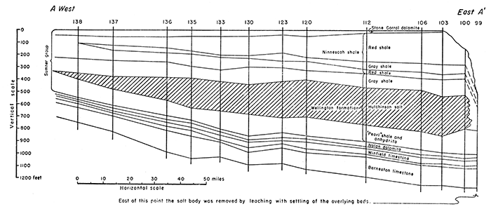
The cross section (Fig. 16) shows the lenticular character of the salt sequence and the attitude of the salt and overlying beds at the end of Sumner time along the line of the Kellett cross section (1932), which traverses the central part of the salt lens. Inasmuch as the unleached salt areas show no definite thinning toward the southeast, it seems probable that at least half the original salt body has been lost by erosion and leaching.
Figure 16--Cross section, west to east, of Sumner group, Leonardian Series, on line A-A' of Figure 15, showing lenticular character of Hutchinson salt member of Wellington shale (after Kellett, 1932). Salt at eastern end of cross section has been dissolved down dip from outcrop area. Well numbers correspond to those of the original cross section by Kellett (1932). [Larger version available as an Acrobat PDF file.]
The outcrops of the upper member of the Wellington are unsatisfactory on account of their disturbed subsidence into the zone of salt solution. The alternation of gray and red shales, which is only vaguely revealed by samples from rotary wells, is well displayed in samples from cable tools wells.
Ver Wiebe's "middle gray beds" unit at the base of the upper member consists mainly of gray shale interbedded with anhydrite, especially near the base. It normally overlies the Hutchinson salt, but outside the salt area this unit cannot be clearly separated from the anhydrite beds of the Pearl shale, although it includes much less anhydrite and some streaks of red shale. It some wells salt molds occur in anhydrite cuttings from above the salt member. The thickness of the "middle gray beds" unit approximates 110 feet in T. 18 S., R. 10 W.
The "red beds" unit of Ver Wiebe consists of red shale but little or no anhydrite. In T. 18 S., R. 10 W., it is 40 feet thick. The "upper gray beds" unit consists mainly of soft gray clay and blue shale; it includes less anhydrite than the base of the member. The thin Milan limestone seen on the outcrops at the top of this member has not been identified in the subsurface. The thickness in T, 18 S., R. 10 W., is 60 feet. The upper member of the Wellington thins toward the north and west, and the thicknesses of -the three characteristic units likewise thin from 110 feet, 40 feet, and 60 feet, respectively, in T. 18 S., R. 10 W., to 40 feet, 10 feet, .and 45 feet in T. 8 S., R. 18 W., as reported in drillers logs of wells drilled with cable tools. The separation of upper Wellington shales from the overlying Ninnescah shale is impracticable in electric logs.
Salt Flow--Correlation of electric logs reveals that the thickness of the evaporite zone including the Hutchinson salt member varies sharply from place to place, as illustrated by the electric logs reproduced in Figure 17. Detailed comparison of these electric logs of wells in the southwest quarter of T. 8 S., R. 17 W., (Fig. 18A) in Rooks County shows that between well b in the SW NW NE sec. 20, and well a in the NW NW SW sec. 19, a distance of 1 1/4 miles (line A of Fig. 18A), the thickness of the evaporite zone increases 58 feet; between well b in the SW NW NE sec. 20 and well c in the SE sec. 29, a distance of 1 3/4 miles (line B), the thickness of the evaporite zone increases 88 feet. Similar variations between other wells are indicated in Table 17.
Figure 17--Correlation of electric logs (a), (b), and (c) of Figure 18 showing abrupt thickening of evaporite zone including Hutchinson salt member of Wellington formation. [Larger version available as an Acrobat PDF file.]
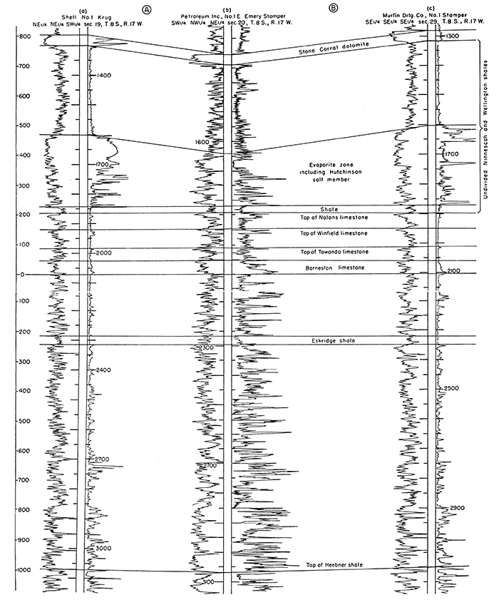
Table 17--Variations in thickness of evaporite zone between wells shown in Fig. 18A, and relation of thickness to structural relief of Stone Corral.
| Line | Between wells |
Distance, miles |
Structural relief of Stone Corral |
Structural relief of Barneston |
Difference in structural relief |
Increase in thickness of evaporite zone |
Structural relief of Heebner shale in Barneston time (Fig. 18B) |
|---|---|---|---|---|---|---|---|
| A | b-a | 1 1/4 | 75 feet | 17 feet | 58 feet | 58 feet | 17 feet |
| B | b-c | 1 3/4 | 112 feet | 24 feet | 88 feet | 88 feet | 20 feet |
| C | d-c | 1 1/8 | 71 feet | 26 feet | 45 feet | 45 feet | 10 feet |
| D | d-e | 1 1/8 | 48 feet | 23 feet | 25 feet | 25 feet | 15 feet |
| E | f-g | 1 3/8 | 44 feet | 28 feet | 16 feet | 16 feet | 10 feet |
It was at first conjectured that the downwarping of the evaporite basin produced local depressed areas in which abnormally thick evaporites accumulated. Closer study showed that the areas of thick evaporites are anticlinal areas.
Figure 18A shows the structure of the base of the Stone Corral dolomite, the structure of the base of the Barneston, and areas of thickened evaporites. The map is based entirely on electric logs, but producing wells and dry holes in the area are also shown. This figure shows the close association of thick evaporites with anticlinal structure. Table 17 shows the relation of the thickening of the salt zone to the structure of the Stone Corral and Barneston on the lines A, B, C, D, and E of Figure 18A. It will be noted that the difference between the structural relief of the Stone Corral and Barneston equals the increase in thickness of the salt zone.
Figure 18--Maps of parts of T. S S., R. 17 and 18 W., Rooks County, showing structure. A. Shows (a) present structure of base of Stone Corral dolomite by 10-foot structure contours, (b) structure of base of Barneston limestone by 10-foot structure contours, and (c) areas of thick evaporites. B. Shows structure of Heebner shale in same area in Barneston time by 10- foot isopachous lines of interval between Heebner shale and Barneston limestone. The structure was similar to the structures in A but of lower relief. [Larger version available as an Acrobat PDF file.]
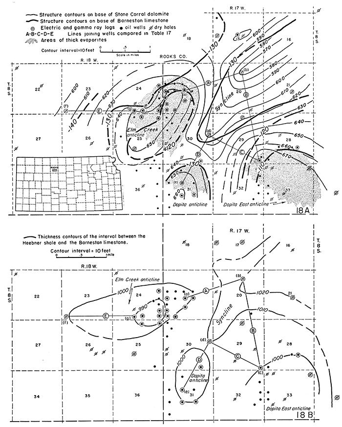
The Barneston limestone and the Heebner shale are dependable datum beds throughout vast areas in Kansas. A thickness map of the interval between them reveals with considerable accuracy the deformation of the Heebner shale at the beginning of Barneston time. Figure 18B is a thickness map of this interval based on the same electric logs that were used in Figure 18A. The map shows structural features similar to those of the Barneston and Stone Corral but of lower structural relief. It indicates that the anticlinal movements revealed by the structure map of the Barneston were already taking form before Barneston time.
The interval from the base of the Barneston to the base of the evaporites is almost uniform in this area, and the thickness of the shale between the top of the evaporites and the Stone Corral is equally constant, irrespective of the thickness of the evaporite as shown in Figure 17. It is clear from Table 17 that the difference between the structure of the Barneston limestone and the structure of the Stone Corral dolomite is due entirely to the thickening of evaporites in structurally high areas.
The concept of abnormal accumulation of salt in local depressions requires the unlikely condition that the areas in T. 8 S., R. 17 W., which were already slightly anticlinal in Barneston time, became synclinal during the deposition of the salt and that later the same areas became again anticlinal. It seems more likely that the thickening of the salt beds and associated anhydrite is the result of the movement of the plastic evaporites toward yielding anticlinal areas.
The uniformity of the thickness of the shale interval between the Stone Corral and the evaporite zone leads to the conclusion that the folding that induced the salt flow did not take place until after the deposition of the Stone Corral dolomite and probably not until after Permian time. The thinning of the Heebner-Barneston sequence indicates that minor movement on the anticlines shown in Figure 18A began before Barneston time and that the ultimate post-Permian movements that caused the readjustment of the salt in this area were a revival of earlier minor folds. It is probable, however, that anticlines newly initiated after Permian time would induce similar exaggerated structure above the salt in the same way.
Although anticlines at the horizon of the Stone Corral are a valid indication of structure in the older rocks, they are not an accurate measure of the structural relief to be expected in formations below the Hutchinson salt beds. The intrusion of salt on anticlines in the area of salt deposition such as the Elm Creek anticline of Figure 18A exaggerates the structural relief of the pre-Wellington formation from which oil is produced in this area.
Because of its tendency to adjust to local structural stresses, the Hutchinson salt member is probably similarly variable in thickness in other areas of salt deposition as yet not studied. The thickness of the Hutchinson salt member ranges regionally from a thin edge at the margin of the basin to more than 500 feet in parts of Russell County and more than 400 feet in Edwards County.
Ninnescah shale--The Ninnescah shale was named by Norton (1939) and described from outcrops in Kingman and Reno counties as consisting predominantly of red shale with minor amounts of gray shale and thin beds of impure limestone and calcareous sand. None of the datum beds recognized in southern Kansas has been identified in the subsurface of the Salina basin, where the Ninnescah, although it includes some red sandstone, consists in most areas almost entirely of red, partly silty shale.
The thickness of the Ninnescah shale as reported in logs of wells drilled by cable tools decreases somewhat irregularly toward the north from about 300 feet in east-central Rice County to 200 feet in southeastern Smith County in the Salina basin. It seems to thicken westward to about 265 feet in Phillips County.
Stone Corral dolomite--This formation of dolomite and anhydrite is the youngest deposit of the Sumner group. It was formerly known as the Cimarron anhydrite, but was more appropriately named by Norton (1939) for an enclosure and fort built of this rock where the Santa Fe Trail crossed Little Arkansas River. It varies in lithology from place to place along the outcrops and in the subsurface. In some places dolomite predominates. At others the Stone Corral is interstratified with thin shale members and anhydrite, and in some places it consists of anhydrite alone. In view of the lack of lithologic continuity it would be more appropriate to designate the sequence as the Stone Corral formation rather than the approved term Stone Corral dolomite. The formation is 30 to 50 feet thick in Pratt, Stafford, and Rice counties. Southeastward in Kingman County it thins to 10 feet, but it shows no consistent trends of thinning in any direction within the area mapped except toward the north in Smith County, where its expression in electric logs is weak or missing. Where the Stone Corral is thin it consists almost entirely of anhydrite. From outcrop studies, Norton (1939) concluded that the Stone Corral is conformable on the underlying Ninnescah, but suggested that there may be a minor unconformity at its top.
Nippewalla Group
The following formations of the Nippewalla group, in descending sequence, have been differentiated in outcrops in southern Kansas: Dog Creek shale, Blaine formation, Flowerpot shale, Cedar Hills sandstone, Salt Plain formation, and Harper sandstone.
All the formations of this group above the Harper sandstone, as well as the entire overlying Guadalupian Series, were eroded from the Salina basin during the hiatus preceding Cretaceous deposition.
In outcrops the Harper sandstone is divided into the Chikaskia and Kingman sandstone members, both of which consist chiefly of red sandstone broken by thin beds of red shale. Subsurface cross sections published by Norton (1939) show that the sandstone members, so prominent in the outcrops, are less conspicuous and more irregular in the subsurface. This seeming change may be due in large part to the fact that grains of disintegrated sandstone are so generally lost in the cuttings from rotary wells. In the subsurface of the western part of the Salina basin the Stone Corral is overlain by red shale, sandy shale, and sandy micaceous shale. The sandstone members of the Harper sandstone, although they may be present, cannot be differentiated in the cuttings of the wells examined. Rocks classified as of Harper age have a thickness of 300 feet in sec. 13, T. 5 S., R. 18 W. These rocks may include some undifferentiated red shales in the base of the Salt Plain formation. Eastward the sandy shales of the Harper are truncated and are overlain by Cretaceous rocks.
Prev Page--Stratigraphy--Pennsylvanian || Next Page--Stratigraphy--Cretaceous to Quaternary
Kansas Geological Survey, Geology
Placed on web Jan. 5, 2017; originally published Dec. 1956.
Comments to webadmin@kgs.ku.edu
The URL for this page is http://www.kgs.ku.edu/Publications/Bulletins/121/03_strat6.html