![]()
Prev Page--Stratigraphy--Mississippian || Next Page--Stratigraphy--Permian
Stratigraphy, continued
Rocks of Pennsylvanian Age
Desmoinesian Series
The Desmoinesian Series of Kansas was formerly divided into the Marmaton group above and the Cherokee group below. Representatives of the Geological Surveys of Iowa, Nebraska, Kansas, Missouri, and Oklahoma* have agreed to divide the Cherokee into two groups, the Cabaniss group above and the Krebs group below, on the basis of exhaustive paleontologic and stratigraphic studies of the outcrops, The Krebs group is capped by the Seville limestone, and the Cabaniss group extends upward to the base of the Fort Scott.†
[* Note: Searight and others, 1953, Classification of Desmoinesian (Pennsylvanian) of northern Midcontinent, Am, Assoc. Petroleum Geologists Bull., v, 37, p. 2747-2749.]
[† Note: At a conference, Oct. 17, 1955, attended by representatives of the State Geological Surveys of Kansas, Nebraska, Oklahoma, and Missouri and the United States Geological Survey, the Krebs and Cabaniss groups were relegated to the status of subgroups and the Cherokee was restored to group status at the discretion of any state.]
Cherokee Group
Unfortunately, the sequence of Desmoinesian rocks below the Marmaton contains no beds of sufficient continuity to be identified with confidence in either well samples or electric logs, with the possible exception of the Verdigris (formerly "Ardmore") limestone in the middle of the Cabaniss subgroup. It is necessary, therefore, in spite of the paleontologic and diastrophic separation of the, Krebs and Cabaniss subgroups in the outcrops, to continue the use of the term Cherokee group in subsurface studies.
The beveled surface that resulted from the erosion of the warped and folded Mississippian rocks was subjected to renewed folding before the Pennsylvanian sea reached Kansas. The rejuvenated folding followed much the same pattern as the folding at the end of Mississippian time, but there was some modification of earlier folds; some structural features were not revived, and some new features were introduced.
When Pennsylvanian sedimentation began in Kansas, movement of the Nemaha anticline had been revived, and the region to the east was already lower than the region to the west. In consequence, the sea advancing from the south in both basins entered the Cherokee and Forest City basins on the east before it submerged the Salina basin on the west. The Nemaha anticline rose by differential movements contemporaneously with the deepening of the basins. The Burns dome on the crest of the Nemaha anticline was not submerged until the end of Cherokee time (Kellett, 1932), In southeastern Nebraska the crest of the Nemaha anticline was not covered until middle Kansas City time, when the Drum limestone overlapped upon the pre-Pennsylvanian surface. (E. C. Reed, personal communication.) The gradually rising crest of the anticline, seldom very high above the adjoining basins, thus formed a southwesterly projecting peninsula of shrinking proportions until long after Cherokee time.
East of the Nemaha anticline, in the outcrops of southeastern Kansas and in the subsurface, the Cherokee group consists mainly of clastics. Light and dark shales predominate, but there is much sandstone and micaceous sandy shale. There are many coal seams and associated clay beds in cyclical succession, but only a few of the coals are thick enough to mine and some are discontinuous. Thin limestone beds were also deposited in cyclical succession, but erosion at the end of each cycle of deposition left only separated remnants with the exception of the Verdigris, which is generally recognizable in the resistivity curves of electric logs in the Cherokee and Forest City basins. It lies about 90 feet below the base of the Marmaton group. The Seville limestone, capping the Krebs subgroup and about 200 feet below the base of the Marmaton, is doubtfully identified in a few electric logs, but only in the southeastern corner of the area.
The Forest City basin was separated from the Cherokee basin by the Bourbon arch in early Cherokee time. Until the Bourbon arch was submerged the deposits in the Forest City basin consisted mainly of black shale, accompanied by some arkosic material derived from Precambrian granite exposed in a small area on the crest of the Nemaha anticline.
The shoestring sands of the Teeters and Sallyard trends in northern Greenwood County in the southeastern corner of the area are offshore bars 'of seas that intermittently advanced into the Cherokee basin (Bass, 1936.) The tops of these buried sand bars lie at depths of 190 to 225 feet below the base of the Marmaton group. Other shoestring sands, which seemingly accumulated in intercyclical erosion channels, occur locally at unpredictable depths. Interbedded sheet sands and irregularly disposed lenticular bodies of sand are also present.
In the Salina basin the sandstone and coal beds so characteristic of the Cherokee in outcrops in southeastern Kansas are not represented. Seams of black shale probably correlative with coal beds in the Cherokee basin are recognized in the samples of some wells, The rocks consist mainly of gray silty shale interstratified with red shale. Toward the margin of the basin, where the Cherokee overlapped upon the differentially rising surface of the Central Kansas uplift, several relatively thin beds of red shale that do not extend far into the basin are commonly present. Each of these beds probably records a nearshore phase of a depositional cycle during which the normal marine phase was inhibited by outwash from the adjacent land areas. Some thin beds of limestone are reported in some wells, but on account of discontinuity or poor representation in the logs they cannot be traced from well to well.
The Pennsylvanian basal conglomerate is well developed in most wells in the Salina basin. It reaches a thickness of 20 to 30 feet in many places but is not present everywhere. Extreme thicknesses exceeding 50 feet have been drilled. The cherty basal conglomerate .is much more common in the Salina basin, where most of the underlying rocks are cherty limestone, than in the Forest City basin, where the widely exposed sparsely cherty or non cherty limestone of Spergen, St. Louis, and Ste. Genevieve ages provided little material for a cherty conglomerate.
In drillers logs and in many sample logs it is impossible to differentiate the Pennsylvanian basal cherty conglomerate from Mississippian chert that weathered in place. Wave action and currents during gradual submergence tend to remove residual debris from topographic crests and redistribute it in channels and basins. The top of the basal conglomerate, therefore, presents a more nearly level surface and consequently a more useful surface in the study of structural deformation than the actual, more irregular surface of the Mississippian. The thickness of the Mississippian and the thickness of the lower Pennsylvanian rocks have therefore been measured from the top of the chert-bearing beds or coarse clastic (basal Pennsylvanian) rather than the top of the true Mississippian surface. This procedure, although not stratigraphically accurate, has the advantage of consistent application, and it is to be understood that references to the thickness of the lower Pennsylvanian rocks exclude the cherty basal Pennsylvanian conglomerate.
In the drillers logs of old wells chert is consistently reported as sand. Beds of "sand" in the position of the basal conglomerate have been assumed to represent chert in some old well logs. The elimination of these doubtful beds from the Cherokee and their inclusion in the Mississippian may have introduced minor errors in the thickness maps where dependence on old drillers logs has been necessary.
East of the Nemaha anticline the Cherokee is 490 feet thick in T. 21 S., R. 16 E., at the northern end of the Cherokee basin; it thins to 385 feet on the Bourbon arch in sec. 23, T. 18 S., R. 10 E., and thickens again to 820 feet in the deepest part of the Forest City basin in sec. 33, T. 1 S., R. 16 E.
In the deepest part of the Salina basin, in sec. 34, T. 2 S., R. 11 W., the Cherokee is only 240 feet thick, but in T. 18 S., R. 4 W., on the saddle separating the Salina basin from the Sedgwick basin it is 105 to 115 feet thick. It is missing on the crest of the Nemaha anticline north of T, 8 S., is 10 feet thick in sec. 32, T. 8 S., R. 9 E., and increases in thickness irregularly southward along the crest to 45 feet in sec. 23, T. 17 S., R. 7 K, and to 70 feet in sec. 30, T. 25 S., R. 5 K, but it is missing on structural and topographic highs.
The Cherokee is separated from the Mississippian limestones by a marked unconformity, but it is essentially conformable with the overlying Marmaton group.
Marmaton Group
The formations of the Marmaton group, named in Table 6 in descending order, have been differentiated and described in outcrops in southeastern Kansas (Jewett, 1945). The range and average thickness of each in southeastern Kansas have been reported by Moore and others (1944, 1951). The thicknesses in southeastern Nebraska are reported by Condra and Reed (1943).
Table 6--Sequence and thickness of formations of the Marmaton group
| Range in thickness in outcrops in southeastern Kansas, feet |
Average thickness in outcrops in southeastern Kansas, feet |
Subsurface thickness in southeastern Nebraska, feet |
||
|---|---|---|---|---|
| Marmaton group | ||||
| Holdenville (Memorial) shale | 0-30 | 10 | missing | |
| Lenapah limestone | 1-18 | 12 | missing | |
| Nowata shale | 3-30 | 18 | 10 | |
| Altamont limestone | 6-25 | 19 | 20 | |
| Bandera shale | 20-50 | 35 | 55 | |
| Pawnee limestone | 15-60 | 30 | 19 | |
| Labette shale | 30-100 | 50 | 25 | |
| Fort Scott limestone | 24-35 | 33 | 36 | |
| Total | 207 | 165 | ||
| Cherokee group | ||||
The Marmaton group consists of a sequence of limestone and shale formations. The limestone formations are interstratified with shale members, and the shale formations include some sandstone and, locally, thin limestone beds. In the outcrops black shale and thin coal beds occur in all formations below the Altamont. Some thin beds of red shale are interbedded in the limestone formations in the subsurface, but the red shales lack continuity over broad areas and probably represent weathering during intercyclical exposure.
The sequence of formations can rarely be determined accurately from drillers logs or sample logs of rotary wells, but are generally revealed in electric logs. From the outcrops in southeastern Kansas the shale beds thin toward the north and west in the subsurface. Intercyclical erosion locally modified the thickness of the limestone formations. In outcrops in northeastern Kansas and in the subsurface on the margins of the Salina basin, pre-Missourian erosion removed the Lenapah and associated shale formations, In the subsurface the sequence of Marmaton formations is generally complete except for the local absence of the Lenapah limestone. All of the formations extend in outcrops into northern Oklahoma.
In the central part of the Salina basin the electric log of the Carter No. 5 Exploration well in sec. 5, T. 5 S., R. 10 W., reveals the following sequence:
| Top of Marmaton group at a depth of 3028 feet | |
|---|---|
| Holdenville shale | missing |
| Lenapah limestone | 22 feet |
| Nowata shale | 15 feet |
| Altamont limestone | 15 feet |
| Bandera shale | 10 feet |
| Pawnee limestone | 20 feet |
| Labette shale | 20 feet |
| Fort Scott limestone | 25 feet |
| Total | 127 feet |
The place normally occupied by Holdenville shale is probably taken by 28 feet of Pleasanton shale. The sandstone members of the Marmaton shale formations that provide reservoirs for oil and gas in the Forest City and Cherokee basins (the "Peru sand" of the Labette shale, the sandstone in the Bandera shale, and the 'Wayside sand" of the Nowata shale), and which are discontinuous in eastern Kansas, are not represented west of the Nemaha anticline in the Salina basin area. The sandstone beds of the Bandera shale formation locally become so calcareous as to be indistinguishable from limestone in electric logs, and in some areas probably grade into limestone. The electric logs reveal discontinuous limestone lentils or calcareous zones in the shale formations of the Marmaton to the confusion of local correlations. The Holdenville shale (formerly Memorial shale) is indistinguishable from the Pleasanton shale unless the latter includes at its base a recognizable sandstone formation. Where the sequence between the Lenapah and the base of the Kansas City group is thin, the Holdenville shale has probably been removed by pre-Missourian erosion.
The thickness of the Marmaton group differs from place to place and in general is responsive to contemporary regional structural movements. East of the Nemaha anticline the succession from the top of the Lenapah to the base of the Fort Scott thins toward the north from 210 feet in sec. 30, T, 29 S., R. 8 E., to 155 feet in sec. 21, T. 7 S., R. 13 E. In the Salina basin, in sec. 5, T. 5 S., R. 10 W., the sequence including the four limestone formations is 127 feet thick. It becomes thinner on the contemporaneously rising flanks of the basin where it overlaps upon the pre-Pennsylvanian rocks. In sec. 10, T. 4 S., R. 7 K, the upper 35 feet of the Marmaton overlaps upon 35 feet of Pennsylvanian basal conglomerate on the west flank of the Nemaha anticline.
The Marmaton is thinner on the crest of the Nemaha anticline than in the adjoining basins, and like the Cherokee it thickens southward along the crest from 70 feet in sec. 6, T. 11 S., R.I0 E., to 155 feet in sec. 14, T. 20 S., R. 7 E. The data reveal that there was general but locally irregular thinning from south to north in the basins as well as along the crest of the Nemaha anticline.
Missourian Series
The Missourian Series is separated from the Desmoinesian Series by an unconformity and by a faunal break. The unconformity was marked by erosion of the upper Marmaton beds and by the development of channels, which were later filled by sandstone deposits. The subordination of the Bronson rocks by which they were reclassified as a subgroup of the Kansas City group was agreed upon at a four-state nomenclature conference of the state geologists of Kansas, Nebraska, Iowa, and Missouri held in Lawrence May 5, 1947. The term Bourbon shale was abandoned in favor of the older equivalent term, Pleasanton group.
The Missourian Series has been divided into the following groups, listed in descending order: Pedee, Lansing, Kansas City (Zarah, Linn, and Bronson subgroups), and Pleasanton.
Pleasanton Group
Four formations of the Pleasanton group, named in descending order in Table 7, have been differentiated in outcrops in southeastern Kansas. The average thicknesses of the formations in eastern Kansas have been reported by Moore and others (1944, 1951).
Table 7--Sequence and thickness of formations of the Pleasanton group
| Average thickness in eastern Kansas, feet |
||
|---|---|---|
| Pleasanton group | ||
| Knobtown sandstone and shale | 30 | |
| Unnamed shale | 60 | |
| Checkerboard limestone (southeastern Kansas only) | 2 | |
| Hepler sandstone | 10 | |
| Total | 102 | |
The Hepler sandstone was deposited in channels and basins eroded in the upper formations of the Marmaton group. On account of the unconformity, the Hepler sandstone and the overlying shale are of variable thickness and character in eastern Kansas, The position of the Knobtown sandstone of Linn and Bourbon counties is occupied farther south by thin beds of dense blue limestone alternating with thin beds of black shale (Moore, Frye, and Jewett, 1944, p. 195). Sandstone has been traced westward by well samples to the crest of the Nemaha anticline in T. 18 S., R. 5 E. on the line of cross section X-X' (well 44, Pl. 11). Westward from this point red shale and gray silty shale, in part finely micaceous, occupy its stratigraphic position. Some black shales and dark shales are locally interbedded with lighter-colored shales. The red shales were probably deposited during submergence after periods of weathering and exposure.
In the Salina basin the Pleasanton shale cannot be separated from the Holdenville shale, although it is probable that its initial deposit was the red shale observed in the samples of many wells. The Holdenville-Pleasanton beds are 20 to 40 feet thick in McPherson County, and in the deepest part of the Salina basin are 15 to 40 feet thick. The sequence is 20 feet thick on the northeastern side of the Salina basin in sec. 1, T. 1 S., R. 2 E., and even less on the southwestern side, where it wedges out in overlap upon the pre-Pennsylvanian surface on the Central Kansas uplift.
On the crest of the Nemaha anticline the Pleasanton is thin or absent. The thickness of the Pleasanton group, although controlled locally by movements of such structural features as the Nemaha anticline, the Salina basin, and the Central Kansas uplift, increases regionally toward the southeast and shows a definite relation to the regional deformation of the Ouachita basin.
Kansas City and Lansing Groups
The Kansas City and Lansing groups, which consist of alternating shale and limestone, were deposited in sequence above the Pleasanton group with cyclical interruptions. The cyclical periods of exposure, during which minor channeling and erosion occurred, were not infrequent, and each exposure reduced in some degree the thickness of the deposits of the preceding cyclothem. The initial clastic deposit of the following cyclothem, for the most part shale, leveled off the surface in most areas before the limestones of the new cycle were deposited.
The Kansas City and Lansing groups are composed dominantly of limestone formations. In the outcrops of southern Kansas some of the limestone formations grade into or interfinger with contemporaneously deposited shale and sandstone. Some of the limestone beds, however, have been traced into Oklahoma. Many of the formations are convenient lithologic groupings of beds without regard to the cyclothems involved. The cyclothems are commonly separated from each other by obscure disconformities within the shale formations (Moore and others, 1951, p. 92-93).
Most of the formations referred to as limestones include shale members of various thicknesses, some of which have characteristics recognizable in outcrops throughout extraordinarily broad areas. In the outcrops the limestone beds display faunal, lithologic, and weathering characteristics by which they are commonly recognized. Most of the distinctive features of color, weathering, jointing, faunal content, and texture, however, cannot be determined in cuttings taken from wells. The identification of formations in sample logs is in consequence dependent upon the sequence of limestone beds and upon the thickness of shale between them, confirmed by fusulines, oolites, and cherts of some limestones, and by the regular occurrence of black, red, olive-colored, and sandy shale units having the rank of members and formations. Unfortunately none of these characteristics can be relied upon with certainty over very broad areas. Both oolites and chert are variable. Algal limestones include oolites in some areas but not in others. Chert is a more or less constant constituent of some limestones in certain areas but is unrecognizable or absent in other areas from beds ordinarily cherty; on the other hand, chert has been found in almost all the limestones at some place in the subsurface. Fusulines are widely distributed but because of their abundance are not very useful as lithologic features, and in samples from rotary wells they have only slight usefulness, because of uncertainty of the source.
Electric logs provide an invaluable means of correlation, but in some areas the orderly sequence of formations is so interrupted by intercyclical erosion that correlation of some limestones from well to well is difficult, especially west of the Nemaha anticline where the intercyclical shales are thin.
Kansas City Group
The formations of the Kansas City group listed in descending order in Table 8 have been differentiated in their outcrops in eastern Kansas. Detailed descriptions of the formations and their thickness in the outcrops have been reported by Moore and others (1944, 1951) in Kansas, and by Condra and Reed (1943) in southeastern Nebraska.
Table 8--Sequence and thickness of formations of the Kansas City group
| Range in thickness in outcrops in southeastern Kansas, feet |
Average thickness in outcrops in eastern Kansas, feet |
Subsurface thickness in southeastern Nebraska, feet |
||||
|---|---|---|---|---|---|---|
| Kansas City group | ||||||
| Zarah subgroup | ||||||
| Bonner Springs shale | 0-60 | 20 | 6-8 | |||
| Wyandotte limestone | 0-75 | 50 | 30-44 | |||
| Lane shale | 15-105 | 50 | 17-18 | |||
| Linn subgroup | ||||||
| Iola limestone | 0-30 | 12 | 3-12 | |||
| Chanute shale | 12-165 | 75 | 14-16 | |||
| Drum limestone | 0-60 | 9 | 8-9 | |||
| Cherryvale shale | ||||||
| Quivira shale member | 3-11 | 7 | 6-14 | |||
| Westerville limestone member | 1-16 | 8 | 17-18 | |||
| Wea shale member | 15-35 | 25 | ||||
| Block limestone member | 3-8 | 4 | 14-30 | |||
| Fontana shale member | 5-25 | 15 | ||||
| Bronson subgroup | ||||||
| Dennis limestone | 2-60 | 40 | 21 | |||
| Galesburg shale | 3-75 | 35 | 8 | |||
| Swope limestone | 0-35 | 23 | 22 | |||
| Ladore shale | 2-50 | 20 | 5 | |||
| Hertha limestone | 0-30 | 16 | 5 | |||
| Total | 409 | 203 | ||||
Samples from the subsurface lack the visible characteristics that distinguish the weathered outcrops; therefore the formations appear as a somewhat monotonous alternation of limestone and shale; the principal characteristics shown by the subsurface samples are the thickness and order of deposition. In most of the area the shales are considerably thinner than in the outcrops, a fact that increases the difficulty of separating the limestone formations in sample logs.
The Kansas City and Lansing formations as represented in sample logs of wells west of the Nemaha anticline seem to consist almost entirely of limestone, but electric logs reveal thin shale beds representing the shale formations and members of the outcrops. Many of the limestone members seem thicker in the subsurface than in outcrops, owing perhaps to the representation in electric logs of the calcareous shales of the weathered outcrops as dense argillaceous limestones.
The Hertha limestone at the base of the Kansas City group is easily recognized in the electric logs of wells in the Cherokee and Forest City basins from its occurrence directly above the long shale sequence of the Holdenville shale and the Pleasanton group. It is absent from some wells on the crest of the Nemaha anticline, but it reappears farther west. In electric logs in the Salina basin and on the flanks of the Central Kansas uplift where the Pleasanton is thin, it is difficult to distinguish the basal formation of the Kansas City group from the limestones and calcareous shales at the top of the Marmaton group. It is probably absent from much of the Salina basin where the Swope limestone seems to be the basal formation.
In many wells red shale in the Pleasanton group is locally a guide in identifying the Hertha, but on the flanks of the Central Kansas uplift red shale occurs also above the Hertha as outwash from pre-Pennsylvanian rocks exposed on the broad crest of the Central Kansas uplift. In doubtful areas, the Hertha can be most confidently identified in electric logs by carrying the contact step by step westward from areas in which it is clearly revealed and cross checking with electric logs to the north and south.
The Swope and Dennis limestone formations are confidently recognized once the base of the Kansas City is established, but the overlying Winterset, Drum;. Iola, and Wyandotte limestones are likely to have been affected by intercyclical erosion. The Drum and Westerville limestone members of the Cherryvale formation are considerably thicker in the subsurface than in the outcrops, and in most of the area constitute almost the whole of the Cherryvale. The Block limestone, if represented, forms a part of the Westerville limestone member.
Intercyclical erosion--The relation of the Lane and Bonner Springs shale formations to the underlying formations is illustrated graphically by the cross sections based on electric logs shown in Figure 14. A cycle of deposition was completed after the deposition of the Iola limestone (Moore and others, 1951, p, 92). The region was elevated, dissection set in, and erosion removed part or all of the Iola in broad open valleys to a depth of 40 feet, as shown by wells Sand 4 of cross section A-B and well 4 of cross section C-D (Fig. 14).
Figure 14--Map of parts of Chase, Lyon, and Greenwood Counties and cross sections showing pre-Bonner Springs erosion and pre-Lane erosion by data from electric logs. Map shows topographic relief of pre-Bonner Springs surface by 50-foot and 25-foot contours. Cross sections of Lansing and Kansas City groups of Missourian Series on lines A-B, C-D, and C-E show topographic relief of pre-Bonner Springs and pre-Lane surfaces. Correlation on the top of Hickory Creek shale member of Plattsburg limestone. [Larger version available as an Acrobat PDF file.]
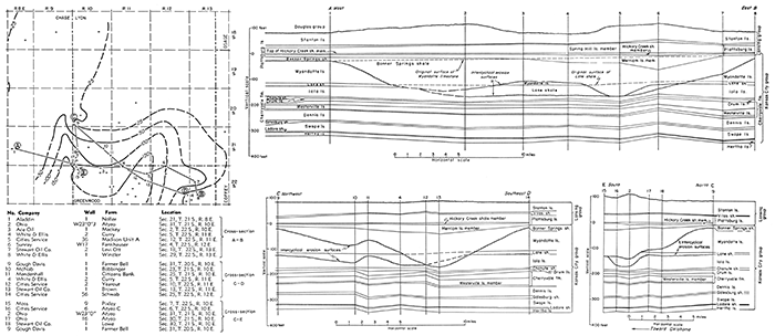
The first deposits of the next cyclothem, the Lane shale, tended to level off the dissected surface, and after filling the eroded basins overlapped upon the undissected or partly dissected upland areas, where shale was deposited to a depth of 5 to 15 feet.
After the deposition of the Wyandotte limestone the region was again raised above sea level. At this time, the elevation was high enough and the exposure was long enough to develop topographic relief of considerable magnitude and to carve out valleys at least 175 feet deep (well 13 of cross section C-D, Fig. 14).
As the region again settled below sea level, the first clastic deposits of the next cycle again filled the eroded areas and distributed shale to a depth of 5 to 30 feet across the upland areas. At well 6, and to a lesser degree in wells 4 and 5, the filling of a tributary, valley by shale was incomplete. As a result, the limestone members of the overlying Plattsburg limestone accumulated to abnormal thickness. It seems probable that the surface of the basin at this point was not completely leveled until the deposition of the Vilas shale, for correlation on the Vilas shale eliminates the apparent anticline at the base of the Hertha limestone.
The inset map (Fig. 14) is based entirely on the interpretation of available electric logs and is designed to show by 50-foot contours the approximate topography of the pre-Bonner Springs surface. The wells of the cross section and map are correlated on the Hickory Creek shale member of the Plattsburg limestone, the first post-Bonner Springs datum that is approximately level in this area.
South of the area of the inset map the Wyandotte, Iola, and even older limestones were generally eroded. Toward the northeast electric logs reveal local pre-Bonner Springs valleys of less relief. Minor increases in thickness of shale members at the expense of the underlying limestone occur in the Wyandotte and in the Chanute formation. The cross sections of Figure 14 show also the irregular surface of the Stanton limestone as a result of post-Lansing erosion.
In the center of the Salina basin in sec. 5, T. 5 S., R. 10 W., the electric log of the Carter Exploration well reveals the following sequence of the Kansas City group:
| Thickness, feet |
Thickness, feet |
||
|---|---|---|---|
| Kansas City group | |||
| Bonner Springs shale | 5 | ||
| Wyandotte limestone | 50 | ||
| Lane shale | 15 | ||
| Iola limestone | 55 | ||
| Cherryvale shale (mainly Westerville limestone) | 65 | ||
| Dennis limestone | 25 | ||
| Galesburg shale | 5 | ||
| Swope limestone | 15 | ||
| Pleasanton shale | 28 | ||
| Total | 235 | 28 | |
The lower formations of the Kansas City group overlapped upon the flank of the contemporaneously rising Central Kansas uplift and Nemaha anticline, Parts of the uplift received no Kansas City limestones older than Winterset, and parts none older than Drum.
The shale formations of the Kansas City, not only in the area of the cross section but also throughout the area, are much thinner than in the outcrops farther east, except under conditions of deep intercyclical erosion. Variations in the thickness of limestones are no doubt due in part to the vagaries of deposition in a vast area, possibly in part to local reefs, and in part to accumulation in depressed areas of the bottom as suggested by cross section C-D. Thinning of limestones where accompanied by increased thickness of overlying shale, however, as at the base of the Vilas shale, at the base of the Island Creek shale member of the Wyandotte, and in the Cherryvale formation, is attributed to intercyclical erosion.
Intercyclical erosion is not commonly noted in the outcrops, partly because so many of the erosion surfaces that were developed between cyclothems were cut in the midst of a shale section and partly because the first deposits of relatively few cycles of deposition were composed of sand or coarse clastics.
Like the other Pennsylvanian groups, the Kansas City group thins northward. It is 350 feet thick in the Ellis No. 3 Barngrover well in sec. 7, T. 23 S., R. 15 E., in the northern end of the Cherokee basin, and 260 feet thick in the Carter No. 4 Exploration well in sec. 24, T. 4 S., R. 16 E. West of the Nemaha anticline it thins from 325 feet in the Anschutz No. 1 Schrag well in sec. 27, T. 19 S., R. 4 W., on the saddle between the Salina basin and the Sedgwick embayment, to 235 feet in the Carter No. 5 Exploration well in sec. 5, T. 5 S., R. 10 W., in the deepest part of the Salina basin.
Lansing Group
The formations of the Lansing group are listed in descending order in Table 9. Detailed descriptions of the formations and their thickness in outcrops in eastern Kansas have been reported by Moore and others (1944, 1951) and in southeastern Nebraska by Condra and Reed (1943).
Table 9--Sequence and thickness of formations of the Lansing group
| Range of thickness in eastern Kansas, feet |
Average thickness in eastern Kansas, feet |
Average thickness in southeastern Nebraska, feet |
||
|---|---|---|---|---|
| Lansing group | ||||
| Stanton limestone | 10-90 | 42 | 32 | |
| Vilas shale | 15-90 | 20 | 11 | |
| Plattsburg limestone | 0-100 | 23 | 10 | |
| Total | 85 | 53 | ||
Both the Stanton and the Plattsburg have been traced in outcrops into southern Kansas. They were deposited throughout the Salina basin area and can be recognized in the electric logs although their thicknesses vary considerably. The Plattsburg in outcrops consists of two limestone members, the Spring Hill above and the Merriam below, separated by the Hickory Creek shale member. These members are represented in all the electric logs. The Spring Hill limestone is commonly less than 10 feet thick and in many places is less than 5 feet thick. In some areas the thickness of the Plattsburg increases locally to more than 50 feet, as in well 6 of cross section A-B of Figure 14, where the Spring Hill limestone member increases from less than 20 feet to more than 40 feet. The Hickory Creek shale maintains a more or less uniform thickness of 5 to 10 feet, although it is scarcely recognizable in a few electric logs.
The Plattsburg in the outcrops generally includes oolitic beds, but oolitic limestone is not present in the Salina basin. The black Hickory Creek shale member, distinct in the outcrops of the Plattsburg, is recognized in the samples of some wells in the Salina basin.
The Vilas shale contains sandy beds and some sandstone in outcrops along Kansas River, but westward in the subsurface the Vilas is thin and contains no sand, although it is locally silty. Red shale is present in the Vilas in some wells: In the Salina basin the thickness of the Vilas does not exceed 10 feet and is generally much less, although it increases locally at the expense of the Plattsburg.
The Stanton limestone formation consists of five members, three limestone beds interstratified with two shale members, of fairly regular thickness and distribution, except the upper limestone member. Neither chert nor oolite is reported. from the outcrops, although the lowest limestone member is siliceous. In the subsurface of the Salina basin, however, the Stanton is generally either cherty or oolitic, but neither chert nor oolite has been recognized in every well. The lower shale member of the Stanton, the black fissile Eudora shale, is a good datum in eastern Kansas, both in the outcrops and in the subsurface. In the Salina basin it has been identified in the samples of some wells. The South Bend limestone member at the top of the formation is of exceptionally variable thickness in many places, owing to an unconformity at the end of Missourian time. The accompanying erosion thinned or removed the South Bend limestone in many localities, but at very few places cut into the older members at the base of the formation. In parts of the area, notably in Dickinson and Marion counties, the South Bend limestone, ordinarily less than 10 feet thick, is 20 to SO feet thick where not eroded, and the underlying Rock Creek shale, elsewhere less than 5 feet thick except in a few places, is locally 20 feet thick.
These variations increase the thickness of the Stanton, the upper formation of the Lansing group, from a normal 20 to SO feet to as much as 75 feet where post-Missourian erosion has not thinned the upper beds. Cross section A-B of Figure 14 shows abnormal depositional thickening of the Stanton as well as thinning due to erosion.
Erosion of the upper part of the Stanton brought about much topographic relief locally. In such areas the top of the Lansing cannot be regarded as a trustworthy datum for detailed contouring, although it is a convenient reference point.
The regularity and consistent expression of the Lansing formation contrasts strikingly to the irregular distribution and thickness of the underlying Wyandotte and Iola limestones. Like other groups, the Lansing thins northward and westward. Where all members are present east of the Nemaha anticline the thickness of the Lansing decreases from 135 feet in the Ohio No. 23 Atyeo D well in sec. 31, T. 21 S., R. 10 E., to 70 feet in Carter No. 4 Exploration well in sec. 24, T. 4 S., R. 16 E. West of the Nemaha anticline the same sequence thins northward from 50 feet in the Anschutz No. 1 Schrag well in sec. 27, T, 19 S., R. 4 W., to 40 feet in the Carter No. 5 Exploration well in sec. 5, T. 5 S., R. 10 W., in the central part of the Salina basin.
Pedee Group
The formations of the Pedee group recognized in outcrops in northeastern and southeastern Kansas are listed in descending order in Table 10. The thickness and character of the formation in Kansas have been reported by Moore and others (1944, 1951) and in Nebraska by Condra and Reed (1943).
Table 10--Sequence and thickness of formations of the Pedee group
| Range of thickness in outcrops in eastern Kansas, feet |
Range of thickness in southeastern Nebraska, feet |
||
|---|---|---|---|
| Pedee group | |||
| Iatan limestone | 0-22 | 0-9 | |
| Weston shale | 0-200 | 0-50 | |
The Weston shale, which overlies the Stanton limestone in probable conformity, consists of dark-bluish to bluish-gray shale that contrasts with the generally yellowish sandy shale of the unconformably overlying Douglas group. At least 200 feet of Weston shale occurs at outcrops in southeastern Kansas and about 100 feet in northeastern Kansas, but in Douglas and Leavenworth counties and elsewhere the Weston shale was eroded during the hiatus between the Missourian and Virgilian Series. The distribution of the Iatan limestone is even more restricted. It has not been identified in the subsurface far from its outcrops in northeastern and southeastern Kansas.
The Weston shale is reported in the subsurface of Woodson and Greenwood counties by Kellett (1932). It may be represented as shown in wells 44, 45, and 46 of cross section X-X' (Pl. 11) by the shale below the Tonganoxie sandstone of the Douglas group. It thins westward from the outcrops and is probably absent throughout the Salina basin,
During the hiatus between the Missourian and Virgilian Series there was widespread and deep erosion, which in many areas exposed the Stanton limestone without, however, cutting much below the South Bend limestone member at its top. The regional topographic relief of the pre-Virgilian surface between southeastern Kansas, where 200 feet of Pedee rocks survived, and areas in which the Stanton was exposed was not less than 200 feet.
Virgilian Series
The Virgilian Series is divided into the following groups, listed in descending sequence: Wabaunsee, Shawnee, and Douglas.
The hiatus that separates the Missourian and Virgilian rocks was accompanied by low regional warping and regional subsidence toward the southeast, as indicated by a westward and northward convergence of the Stanton limestone and the base of the Oread limestone.
Douglas Group
The formations of the Douglas group, represented in outcrops in eastern Kansas, are listed in descending order in Table 11. The range of thickness in outcrops in eastern Kansas is reported by Moore and others (1944, 1951) and in southeastern Nebraska by Condra and Reed (1943).
Table 11---Sequence and thickness of formations of the Douglas group
| Range of thickness in eastern Kansas, feet |
Range of thickness in southeastern Nebraska, feet |
||
|---|---|---|---|
| Douglas group | |||
| Lawrence shale | 40-175 | 19-42 | |
| Stranger formation | 40-220 | 17-24 | |
The Stranger formation in the outcrops consists of yellowish-gray shale and sandstone and includes one or two limestone members in the upper part. The Stranger formation is thickest in places where the Pedee was deeply eroded or entirely removed. The lower part includes the Tonganoxie sandstone member, which is irregular in distribution and character. The Tonganoxie sandstone is absent in some places and in others has a thickness of as much as 90 feet. The Haskell limestone member, in the upper part of the Stranger formation above the Tonganoxie sandstone, is in places as much as 10 feet thick, but it is generally thinner. The Haskell limestone is very persistent, but the interval between this limestone and the base of the Shawnee group above is so variable that the Haskell seems to have been deposited on an uneven surface. The Haskell limestone, in consequence, is an untrustworthy datum for detailed contouring.
In outcrops the Lawrence shale consists chiefly of blue-gray and yellowish shale, but it includes a thin discontinuous limestone member (Amazonia limestone) near the top and the tan Ireland sandstone member, of irregular thickness and distribution, at its base. An unconformity of considerable erosional relief separates the Stranger formation and the Lawrence shale. The thickest deposits of Ireland sandstone lie in deeply eroded areas of the Stranger formation; in some places the base of the Ireland reaches below the Haskell limestone and is even in contact with the Tonganoxie. A very persistent bed of red shale near the top of the Lawrence shale is widely distributed in outcrops in eastern Kansas and southeastern Nebraska. In the subsurface it extends into western Kansas, where it persists although all other parts of the Lawrence shale have wedged out. It seems to be the first deposit of a cyclothem that includes the basal members of the Oread limestone, the first formation of the Shawnee group,
The Tonganoxie sandstone occurs mainly in the Forest City basin area east of the Nemaha anticline and fingers out on the margin of the basin. It is doubtful whether it is represented in the Salina basin. In McPherson and Marion counties the greater part of the Stranger formation is made up of Ireland sandstone, which is locally more than 150 feet thick (Kellett, 1932). The Ireland sandstone thins out toward the northwest, In the Salina basin, sandstone beds are uncommon in the Douglas group north of Saline County,
On the western flank of the Nemaha anticline as far south as Riley County two to five limestone beds 5 to 20 feet thick are interstratified with Douglas shale, which in this area is 75 to 90 feet thick. The most persistent of these limestones lies near the base of the Douglas group 5 to 20 feet above the South Bend limestone member of the Stanton formation. It is revealed by electric logs throughout much of the Salina basin, where it is 10 to 20 feet thick, but it has not been reported in outcrops. It might plausibly be regarded as a part of the Lansing group except that the top of the Lansing has been placed at the top of the Stanton.
The Douglas group, combined with remnants of the Pedee Weston shale, thins northwestward from 275 feet in the K & E Drilling Company No. 2 Mohr well in sec. 29, T. 20 S., R. 10 E., to 5 feet in the Texas Company No. 1 Armstrong well in sec. 2, T. 5 S., R. 18 W.
Deformation along the east flank of the Nemaha anticline is revealed by the abrupt thinning of the sequence between the top of the Stanton and the base of the Oread limestone. In a distance of 2 1/2 miles the sequence decreases from 185 feet in the Amerada No. 1 Elizabeth Enlow well in sec. 4, T. 11 S., R. 10 E., to 150 feet in the Amerada No. 1 Mertz well in sec. 6, T. 11 S., R. 10 E., near the crest of the anticline. West of the crest the section continues to decrease to 120 feet in T. 10 S., R. 9 and 8 E. In the deepest part of the Salina basin, still farther west in T. 2 S., R. 11 W., the section is only 10 feet thick. The data seem to indicate that there was uplift west of the east flank of the Nemaha anticline but little or no arching of the crest, and at the same time a regional tilt toward the southeast, hence less shale deposition on the rising area toward the northwest.
Shawnee Group
The formations of the Shawnee group are listed in Table 12 in descending sequence. The thicknesses of the formations at outcrops in eastern Kansas are reported by Moore, Frye, and Jewett (1944, p. 177-182) and Moore and others (1951). The thicknesses in southeastern Nebraska are reported by Condra and Reed (1943, p. 46-49).
Table 12--Sequence and thickness of formations of the Shawnee group
| Range of thickness in outcrops in eastern Kansas, feet |
Average thickness in outcrops in eastern Kansas, feet |
Thickness in outcrops in southeastern Nebraska, feet |
||
|---|---|---|---|---|
| Shawnee group | ||||
| Topeka limestone | 33-55 | 35 | 27-40 | |
| Calhoun shale | 10-45 | 30 | 2 1/2 | |
| Deer Creek limestone | 20-80 | 40 | 29-32 | |
| Tecumseh shale | 65-12 | 35 | 32-50 | |
| Lecompton limestone | 30-50 | 34 | 30-36 | |
| Kanwaka shale | 40-15 | 80 | 7-37 | |
| Oread limestone | 52-100 | 70 | 47-54 | |
| Total | 324 | Aver. 212 | ||
The formations referred to as limestones are convenient groupings of limestone beds separated by thin shales without regard to division into cyclothems. The formations, all of which have been traced in outcrops across the state from Nebraska to Oklahoma, vary considerably in thickness. The thicknesses of the individual limestone and shale members of the formations also differ from place to place, and abnormally thin limestones in local areas are generally overlain by thick shales.
Samples of the limestones from wells do not present any distinguishing lithologic characteristics. Each limestone of formational rank includes one or more algal members, some of which are oolitic in outcrops, but oolites are infrequently recognized in the well samples. Also, each limestone of formational rank includes a bed of black shale. Parts of the Oread and Topeka limestones are cherty in the outcrops, but all the limestones are cherty at some points in the subsurface. All the limestone formations include one or several members containing fusulines.
All the shale units that are formations include sandstone and sandy shale at the outcrops, In the subsurface, sandstones and sandy shale occur intermittently in the Calhoun, Tecumseh, and Kanwaka shales as far west at T. 1 W. Farther west none of the shale units of formation rank is more than 10 feet thick, and in some wells they cannot be recognized in the samples, although thin shale beds are revealed by electric logs. In the absence of conspicuous shale units, it is difficult to identify, in the subsurface, the limestone formations defined at the outcrops.
In electric logs, the Oread limestone formation at the base of the Shawnee is one of the most distinctive and most easily identified Pennsylvanian formations. Although the Oread includes all or parts of 4 cyclothems (Moore and others, 1951, p. 7C), all the members of the Oread are represented throughout the area.
The black fissile Heebner shale member, near the middle of the formation, is the most distinctive datum in the Pennsylvanian system. Its thickness ranges from less than 1 foot to more than 10 feet. It is underlain by the thin Leavenworth limestone, the Snyderville shale, and the Toronto limestone members. In places, especially toward the west, the Snyderville, ordinarily 10 to 15 feet thick, attains a thickness of 50 feet or more. Where the underlying Douglas shale is thin and the Snyderville is thick, the Toronto limestone has occasionally been misidentified as Haskell limestone. The thick Plattsmouth limestone overlies the Heebner. The Heumader shale and the Kereford limestone overlie the Plattsmouth; the Kereford varies considerably in thickness, probably as a result of intercyclical erosion.
The Clay Creek limestone member of the Kanwaka shale formation is an argillaceous limestone 5 feet thick in outcrops. It seems to increase in thickness in the subsurface, where in some wells, either by the increasingly calcareous character of the shale or by thickening of the limestone, it constitutes the greater part of the Kanwaka.
The Lecompton limestone formation appears in electric logs as a somewhat variable sequence of thin limestone and shale members dominated by the Beil and Avoca limestone members.
The Deer Creek limestone formation is most conspicuously represented by the Ozawkie and Ervine Creek limestones.
The Calhoun shale formation, which overlies the Deer Creek, thins toward the west, where the Deer Creek closely approaches the Topeka limestone formation.
The Topeka limestone formation consists of a sequence of six limestone members alternating with shale members. The thin upper limestone members are not everywhere distinguishable in electric logs, owing partly to erosion of the top of the Topeka or to nondeposition of the thin upper limestones toward the west. The two lower limestone members, the Curzon and Hartford members, are each 10 to 15 feet thick and are represented in nearly all electric logs. As a matter of expediency, the top of the Curzon limestone has been used as a datum, although some of the younger members of the formation are represented in many areas.
A comparison of the average thicknesses of the formations of the Shawnee group in outcrops in eastern Kansas and southeastern Nebraska (Table 12) reveals that with two exceptions all the formations thin northward, although the limestones thin much less than the shales. The Tecumseh and Calhoun shales are the exceptions to northward thinning. The maximum thickness of both these shales is reported in outcrops in the Kansas River valley, where the Tecumseh is 65 feet thick and the Calhoun is 45 feet thick. The outcrops of both are thinner north and south of this area (Moore, Frye, and Jewett, 1944, p, 178-179). In view of the not uncommon intercyclical erosion, which locally reduced the thickness of exposed limestones, it seems not unlikely that such unusual local increases in the thickness of clastic deposits are the result of leveling off of topographic relief at the beginning of a new cycle of sedimentation. The local thickening of shale formations may, however, be due to local synclinal warping or possibly to uneven sedimentation.
Like the Douglas, the Shawnee group thins on the crest of the Nemaha anticline, It is 400 feet thick in the Amerada No. 1 Elizabeth Enlow well in sec. 4, T. 11 S., R. 10 E., in the syncline to the east of the anticline; it is 310 feet thick in the Amerada No. 1 Mertz well in sec. 6, T. 11 S., R. 10 E., 2Jf miles farther west near the crest of the anticline; and 280 feet thick in the Parker Oil Company No. 1 Bardwell well in sec. 26, T. 10 S., R. 9 E., near Zeandale. Westward into the Salina basin its thickness ranges from 270 to 290 feet. These thicknesses seem to indicate that, as during the deformation in Douglas time, the region east of the Nemaha anticline was subsiding faster than the region to the west but that there was no arching of the anticline.
There is overall thickening of the Shawnee group toward the southeast irrespective of differences resulting from local structural movements. The Shawnee group is 255 feet thick in sec. 15, T. 13 S., R. 17 W., on the crest of the Central Kansas uplift; it is 244 feet thick in sec. 10, T. 5 S., R. 10 W., but thickens to 305 feet in sec. 27, T. 19 S., R. 4 W., on the saddle between the Salina basin and the Sedgwick embayment; and it is 375 feet thick in sec. 31, T, 23 S., R. 10 E., on the western flank of the Cherokee basin.
The southeastward thickening of the Shawnee group is due mainly to the thickening of the shale deposits and only in minor degree to thickening of the limestones.
Wabaunsee Group
The formations of the Wabaunsee group, listed in Table 13 in descending sequence, have been differentiated in the outcrops in eastern Kansas and southeastern Nebraska. The thicknesses in Kansas are reported by Moore and others (1944, 1951) and those in southeastern Nebraska by Condra and Reed (1943).
Table 13--Sequence and thickness of formations of the Wabaunsee group. [Note: At a conference Oct, 17, 1955, attended by representatives of the State Geological Surveys of Kansas, Nebraska, Oklahoma, and Missouri and the United States Geological Survey, the thin stratigraphic units of the Wabaunsee group above the Howard limestone, heretofore listed as formations, were reduced to the rank of members and grouped in formations to which new names, not yet officially announced, are to be applied.]
| Range of thickness in outcrops in eastern Kansas, feet |
Average thickness in outcrops in eastern Kansas, feet |
Range of thickness in southeastern Nebraska, feet |
||
|---|---|---|---|---|
| Wabaunsee group | ||||
| Brownville limestone | 2-8 | 5 | 2 | |
| Pony Creek shale | 5-20 | 14 | 5 | |
| Caneyville limestone | 21 | 21 | 11-13 | |
| French Creek shale | 30 | 30 | 8 | |
| Jim Creek limestone | 1/4-2 | 1 | 1 | |
| Friedrich shale | 15 | 15 | 41-44 | |
| Grandhaven limestone | 10 | 10 | ||
| Dry shale | 5-20 | 15 | 14 | |
| Dover limestone | 2-20 | 10 | 2-5 | |
| Langdon shale | 5-50 | 30 | not reported | |
| Maple Hill limestone | 1-5 | 3 | 15 | |
| Wamego shale | 6-25 | 17 | not reported | |
| Tarkio limestone | 0-10 | 6 | 3-7 | |
| Willard shale | 30-66 | 40 | 28-30 | |
| Elmont limestone | 1-15 | 5 | 2-4 | |
| Harveyville shale | 1-25 | 10 | 12-20 | |
| Reading limestone | 2-15 | 6 | 3-5 | |
| Auburn shale | 20-70 | 50 | 14-30 | |
| Wakarusa limestone | 2-18 | 8 | 3-6 | |
| Soldier Creek shale | 12-18 | 15 | 12-14 | |
| Burlingame limestone | 4-16 | 9 | 20 | |
| Silver Lake shale | 25 | 25 | 10-12 | |
| Rulo limestone | 2 | 2 | 1-2 | |
| Cedarvale shale | 25 | 25 | 19-20 | |
| Happy Hollow limestone | 1-8 | 4 | 6-8 | |
| White Cloud shale | 30-80 | 50 | 80 | |
| Howard limestone | 8-30 | 13 | 3-7 | |
| Severy shale | 75 | 75 | 22-29 | |
| Total | 514 | Aver. 369 | ||
The Wabaunsee group comprises a sequence of alternating limestones and shales. Most of the limestones are relatively thin but nearly all extend in outcrops from southeastern Nebraska to Oklahoma. On the outcrop, the Howard limestone in places is 30 feet thick, the Wakarusa reaches 18 feet, the Reading 15 feet, and the Dover 20 feet. In most places, however, the thicknesses of these limestones do not exceed 5 feet and in many places 2 or 3 feet.
The sum of the average thicknesses of all limestones of the Wabaunsee group, in the outcrops in Kansas, including the shale members of formations composed mainly of limestones, is only 104 feet, or about 20 percent of the total of the group. In outcrops, many of the shale units include sandy shales, and many include beds of sandstone. Streaks of coal, some of which are thick enough to have been mined near the outcrop, occur in nearly all the shales, but coal is seldom recognized. in washed samples from the subsurface. Thin discontinuous limestones are not uncommon in the shales, and thin limestones that probably appear as unnamed calcareous marine shale in outcrops are noted in the subsurface in some wells. On the other hand, some limestones reported in drillers logs are probably indurated shales. Some of the widely distributed limestones of the outcrops are only occasionally recognized and reported in sample logs, because they are thin and argillaceous, As a result there is considerable confusion and uncertainty in the identification of individual formations in both sample and drillers logs of many wells that penetrate the Wabaunsee group.
The electric logs reveal, more or less clearly, most of the thin named limestone units of the outcrops, but their multiplicity and the variations in the thickness of the intervening shale beds is a source of confusion. Some units seem to wedge out or to have been irregularly deposited, but where beds are represented only at random in electric logs, their absence is probably due to intercyclical erosion.
The Howard limestone, which is 20 feet thick in the Cherokee basin but in very few places elsewhere exceeds 10 feet, is present throughout the area. It is clearly identified in most electric logs as two limestone members, separated by a thin shale, but in some areas one of the limestone members is missing. The interval between the Topeka and the Howard is 85 feet in T. 20 S., R. 8 E., in the Cherokee basin but only 20 feet on the crest of the Central Kansas uplift.
The Happy Hollow limestone varies in thickness. Its distance above the Howard decreases westward. The Rulo limestone, above the Happy Hollow, is erratic in distribution and generally missing. The coal or black shale seen in outcrops of the Cedarville shale, between the Happy Hollow and the Rulo limestones, has also been noted in the samples from some wells. A red bed in the shale between these limestones is useful in local correlations of sample logs.
As the intervening shales become thinner toward the north and west, the thin limestones of the upper part of the Wabaunsee tend to fall into groups. The Burlingame and the Wakarusa approach each other, but they are missing in many wells in the Salina basin. Similarly the Elmont and Reading limestones draw closer together. A red shale between the Reading and the Wakarusa limestone has been helpful in identifying these limestones in sample logs.
The Grandhaven, Dover, Maple Hill, and Tarkio limestones appear as a group in some areas, although one or more of the limestones is missing in many wells. Samples of the Tarkio limestone are characterized by an abundance of exceptionally large fusulines. The Maple Hill limestone is thin and doubtfully present in the Salina basin. The Dover limestone, on the other hand, is persistent.
The limestones of the Wabaunsee group above the Dover are thin and where present are identified mainly by the intervals between them, A thin limestone that is present in most electric logs at a suitable interval above the Dover limestone is tentatively identified as the Brownville. Beds of sandstone and sandy shale are discontinuously interbedded in nearly all of the shale formations of the Wabaunsee.
The relation of the Wabaunsee group at the top of the Pennsylvanian System to the overlying Admire group at the base of the Permian System is obscure in the subsurface. The lower beds of the Admire, like the upper beds of the Wabaunsee, consist of sandy shale, sandstone, and thin interstratified limestone beds, none of which can be satisfactorily identified in the subsurface in either sample or electric logs. In outcrops in Lyon County, O'Connor (1953, p. 8-23) reported a complete sequence of upper Pennsylvanian and lower Permian rocks without encountering the pronounced dis conformity represented by the Indian Creek sandstone, which was deposited in valleys eroded to a depth of 120 feet. These channels occur at several places in outcrops in Nebraska and eastern Kansas (Moore and others, 1951, p, 52). Harned and Chelikowsky (1945) report erosion of 250 feet of Wabaunsee rocks,
Most of the electric logs examined display a more or less normal sequence of upper Wabaunsee formations culminating in the Brownville limestone similar to the sequence of formations seen in outcrops in Lyon County, A few wells in T. 12 S., R. 2 W., and adjoining townships reveal a sequence of sandstone and sandy shale extending down to the horizon of the Dover limestone without limestone breaks.
The inference drawn from these observations is that at the end of Wabaunsee time the region was elevated high enough above sea level to allow the trenching of valleys possibly as much as 250 feet deep. Erosion, however, did not continue long enough to bring about the general dissection of the surface, As was the case of pre-Bonner Springs and other intercyclical exposures, the returning sea filled the eroded valleys with clastic sediments--at this time sand--and overflowed upon the only slightly dissected upland areas upon which the succeeding deposits of a new cycle of sedimentation were deposited.
It seems probable that in places the Brownville was still covered by Pennsylvanian shales upon which early Permian sediments of similar character were deposited, The thickness of the Wabaunsee rocks is in this sense indeterminate, but it can be approximated by using the top of the Brownville as a datum.
The average thickness of the Wabaunsee group in outcrops in the basin area of eastern Kansas is 514 feet. A composite section of the same sequence measured in southeastern Nebraska by Condra and Reed (1943) indicates a northward thinning of the Wabaunsee to 369 feet. In the subsurface in the Cherokee basin in sec. 30, T. 20 S., R. 10 E., the Wabaunsee is 485 feet thick. West of the Nemaha anticline on the divide between the Salina basin and the Sedgwick embayment, in sec. 27, T. 19 S., R. 4 W., the Wabaunsee is 465 feet thick. It thins northward across the Salina basin to 360 feet in sec. 34, T. 2 S., R. 11 W., and in sec. 5, T. 5 S., R. 10 W. Northwestward on the crest of the Central Kansas uplift its thickness decreases from 355 feet in sec. 23, T, 15 S., R. 12 W., to 315 feet in sec. 6, T. 7 S., R. 20 W., where the Wabaunsee beds above the Dover seem to have been eroded during the hiatus preceding the Permian. The thickness in general decreases toward the northwest but is modified by local structural features and locally by pre-Permian erosion.
Prev Page--Stratigraphy--Mississippian || Next Page--Stratigraphy--Permian
Kansas Geological Survey, Geology
Placed on web Jan. 5, 2017; originally published Dec. 1956.
Comments to webadmin@kgs.ku.edu
The URL for this page is http://www.kgs.ku.edu/Publications/Bulletins/121/03_strat5.html