![]()
Prev Page--Contents || Next Page--Stratigraphy--Precambrian to Cambrian
Introduction
The original report on the Salina basin was prepared during the period from September 1943 to June 1946 by Wallace Lee with the collaboration of Constance Leatherock and Theodore Botinelly, under a cooperative agreement between the Geological Survey of Kansas and the U. S. Geological Survey. By 1950 so many new wells had been drilled in the area that it became desirable to revise the original report, again under a cooperative agreement between State and Federal Surveys. The new data proved to be so voluminous, however, that it has been necessary to reexamine all phases of the original report and to prepare new maps and many new cross sections. The completion of the work in 1953 to 1955 has been carried on by the State Survey without Federal cooperation.
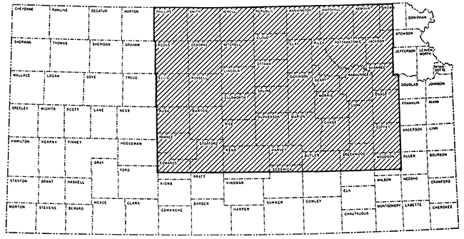
The work of Leatherock and Botinelly for the original report has been invaluable in the revision, but the examination and coordination of data from new wells, several times as numerous as were formerly available, have been carried on by the present author. All data available to June 15, 1955, have been incorporated in the revised report (Fig. 1).
Figure 1--Map of Kansas showing area covered by this report.
It is probable that even before the publication of this bulletin, new wells will provide increased information at many points. The project was designed primarily as a study of regional deformation and, except locally, the data do not warrant isopachous lines drawn at intervals less than 50 feet. Closer contouring based on accurate records would reveal much of interest in the growth of local anticlines, but such detail was not the object of this report. New data will ultimately reveal desirable information in the northern parts of the Salina basin, where few wells have been drilled.
The report follows the plan of the earlier report on the Salina basin (Lee, Leatherock, and Botinelly, 1948). The analysis of the complex regional stratigraphy and structure with which the report is primarily concerned will be useful in guiding future drilling, not only in this area but also in bordering areas where the relations of overlap and regional structure are similar and have an important bearing on the accumulation of oil. Local structural features, to which oil company geologists give special attention, have not in general been the subject of study in the present investigation.
The Salina basin was first defined by Barwick (1928, p. 179) as "The pre-Pennsylvanian syncline bounded on the east by the Nemaha granite ridge [now Nemaha anticline], on the southwest by the Barton arch [now Central Kansas uplift] and on the south by the saddle between the Chautauqua arch and the Barton arch. The basin continues northward into Nebraska where its exact termination is not known." The Barton arch, a name suggested by Barwick, is now more generally known as the Central Kansas uplift, and since 1926 (Ley, 1926) the Nemaha granite ridge has been recognized as a post-Mississippian beveled anticline.
The Salina basin lies on the margin of an earlier structural basin referred to by Rich (1933) as the North Kansas basin. The Salina basin had no separate existence until the uplifting of the Nemaha anticline divided the North Kansas basin and developed the Salina basin on the west and the Forest City basin on the east. These basins were at first structural basins revealed by the beveling of pre-Pennsylvanian rocks. During Pennsylvanian time they were subsiding areas in which Pennsylvanian deposits accumulated in greater thickness than on the margins.
Most of the Salina basin lies in Kansas, but synclinal warping extended northwest into Nebraska, and the northeastern flank of the basin extends north into Nebraska along the west side of the Nemaha anticline. No attempt has been made in this report to study the Nebraska portion of the Salina basin and adjoining structural features.
The data upon which the report is based were derived from sample logs of wells prepared in the Geological Survey of Kansas, sample logs of the Kansas Sample Log Service, electric logs, drillers logs by unidentified geologists, and old drillers logs of cable-tool wells. The last have been used with caution in areas where no other data are available.
Many old drillers logs could not be used, owing to inaccurate logging or obvious unrecorded corrections of depth. The logs of many early wells generally designate as sand all cherty beds, water-bearing beds, and coarsely sucrose dolomites. Through a comparison of these old logs with recent electric and sample logs, it has been possible to identify essential datum beds in many logs that were previously discarded.
The data are of unequal value, on account of the character of samples available, inaccuracies in measuring depths, unequal lag of samples from rotary wells, and other factors. Electric logs are most dependable and old drillers logs least so. Some logs in all categories had to be rejected for obvious errors. There is almost an embarrassment of wells in the southern part of the area, but in parts of the Salina basin the wells are widely scattered.
The criteria by which most of the formations have been identified were determined at identified outcrops, many of which are distant from the Salina basin. Facies changes in the subsurface have been determined by comparison of samples and insoluble residue in successive wells. Table 1 lists the outstanding physical characteristics of cuttings and insoluble residues as seen under the microscope.
Table 1--Sequence of pre-Pennsylvanian formations encountered in the Salina basin, their range of thickness, and distinctive physical characteristics of well cuttings under the microscope.
| System | Series | Correlatives | Formations and members |
Approximate thickness, feet |
Distinctive physical characteristics (Detailed descriptions will be found in the text) |
|---|---|---|---|---|---|
| Mississippian | Meramecian | Spergen limestone |
0-99 | Noncherty or sparsely cherty granular limestone at top and silty dolomite at base. The small insoluble residues, rarely more than 5 percent, are characterized by salmon-colored chalcedonic chert. May include traces of microfossiliferous chert. Granular limestones may contain sparsely distributed Endothyra. | |
| "Warsaw" limestone |
0-80 | Chert, opaque, partly gray and partly dark, characteristically packed with silicified broken micro-organisms an spicules. Chert constitutes 10 to 50 percent of samples. | |||
| Osagian | Undivided Keokuk and Burlington limestones |
0-110 | Upper zone: Chert, white. rough, pitted, and porous. Cotton rock in some samples. Residues include soft spongy particles resembling tripoli. Includes, also, in some zones microfossiliferous organisms similar to those in chert of the "Warsaw" limestone but embedded in chalcedony. | ||
| 0-155 | Lower zone: Chert, abundant, mainly white, opaque, microscopically massive, breaking in smoothish blocky chips. Hackly quartz present in samples and drusy quartz common in insoluble residues. | ||||
| Rocks of Fern Glen age |
Reeds Spring limestone |
0-120 | Chert, bluish to bluish gray or gray, translucent to semi translucent, breaking in sharp-edged chips and splintery fragments. | ||
| St. Joe limestone |
0-40 | Noncherty or sparsely cherty, dark-gray to gray, argillaceous limestone of earthy or finely crystalline texture. | |||
| Kinderhookian | Gilmore City limestone |
0-62 | Oolitic limestone in part, with soft chalky matrix; not oolitic throughout. Nonoolitic limestone is granular. Residues negligible. | ||
| Upper member of Sedalia dolomite |
0-20 | Buff to brown, locally gray, noncherty or sparsely cherty sucrose dolomite. | |||
| Mississippian or Devonian |
Kinderhookian or Late Devonian |
Boice shale | 0-110 | Red and brown ironstone oolite, and red shale at base. | |
| Chattanooga shale |
0-255 | Gray to black, generally silty, finely micaceous shale. Pyrite common. Spores disseminated throughout but abundant near base. Includes thin beds of argillaceous sucrose dolomite and locally toward the west a thick lentil of argillaceous limestone. | |||
| Devonian | Late | Undifferentiated dolomite of Devonian age; includes Cooper dolomite |
0-200 | Contains, in lower zone, coarse rounded sand grains thinly disseminated in dolomite or limestone but generally abundant at base. | |
| Silurian | Niagaran and Alexandrian |
Undifferentiated rocks of Silurian age; includes Chimneyhill dolomite |
0-315 | In ascending order: First zone, characterized by oolitic dolomite; Second zone, characterized by white chert; Third zone, characterized by small silty insoluble residues containing rare specimens of Ammodiscus and other foraminifera and glauconite, locally streaked with red or pink dolomite or limestone; Fourth zone, characterized in the upper part by insoluble residues of drusy and hackly quartz and the quartz crystals in the northeastern part of the area and by dolocastic and spongy chert in the southern and western parts of the area. Contains much variegated semiopaque to semitranslucent chert in marginal areas in northwestern part of area. | |
| Ordovician | Late | Sylvan shale of Oklahoma |
Maquoketa shale |
0-155 | Gray and greenish-gray silty and nonsilty dolomitic shale. Locally includes cherty dolomite yielding large insoluble residues of very dolocastic semitranslucent chert. Insoluble residues of shale are, generally, dolocastic in contrast to Chattanooga shale. |
| Middle | Part of Viola limestone of Oklahoma |
Viola limestone |
0-310 | Chert with embedded black or dark tubular microorganisms; buff chert enclosing densely matted silicified microorganisms. Alternate zones sparsely cherty. | |
| Rocks of Simpson age in Oklahoma |
Platteville formation |
0-95 | Sublithographic limestone, dolomite, and sandstone interbedded with green shale; a persistent bed of sucrose dolomite at the base, little or no chert. | ||
| St. Peter sandstone |
0-90 | Coarse rounded to subangular sand interbedded with green shale. | |||
| Early | Rocks of Arbuckle age in Oklahoma |
Undivided Cotter dolomite and Jefferson City dolomite |
0-400* | Upper part. abundant chert of variable character, much oolitic chert; oolites commonly brown or translucent in light-colored matrix; lower part, less cherty, oolitic chert, predominantly white and in lesser volume. Tripoli-like chert increasingly common in insoluble residues toward the base. | |
| Roubidoux dolomite |
0-247 | Sand less abundant than in Missouri. Generally, sandy dolomite in Kansas. Sand in most Kansas areas fine grained. Includes minor amounts of chert, in part oolitic. | |||
| Gasconade dolomite |
0-50 | Present in eastern Kansas but not in central Kansas. | |||
| Cambrian | Late | Eminence dolomite |
0-35 | Present in eastern Kansas but not in central Kansas. | |
| Bonneterre dolomite |
0-183 | Noncherty argillaceous dolomite with glauconite. In central Kansas includes dis- seminated sand but is not argillaceous. | |||
| Lamotte sandstone in Missouri |
Reagan sandstone |
0-80 | Coarse angular to rounded poorly sorted sand. | ||
| Precambrian | Precambrian rocks |
Arkose, granite, and quartzite. |
Logs of more than 4,300 wells have been studied in the preparation of this report. Samples from nearly 1,000 wells were examined in whole or in part by Lee and his coworkers Leatherock and Botinelly. Use was made of 885 logs of the Kansas Sample Log Service, a large proportion of which are of wells on the Central Kansas uplift, and 445 electric logs were used especially for Pennsylvanian data. Tops of formations reported by unidentified geologists in more than 2,000 drillers logs were checked in the preparation of the thickness maps, although not all were used. In addition, 13,000 drillers logs of various degrees of accuracy were plotted to determine the pre-Pennsylvanian areal geology of the Central Kansas uplift.
On the maps that show the thickness of the different parts of the rock sequence in the Salina basin, the lines indicating equal thickness are spaced at 50-foot intervals. Differences in the degree of accuracy of the data precluded use of a smaller interval, although intervals of 25 feet or less would doubtless bring out many local structural features, particularly in oil fields, where local deformation accompanied regional deformation throughout Pennsylvanian and Permian time. Furthermore, the object of the investigation was the study of regional rather than local deformation. For this same reason only one or two wells in a land section were used in densely drilled areas.
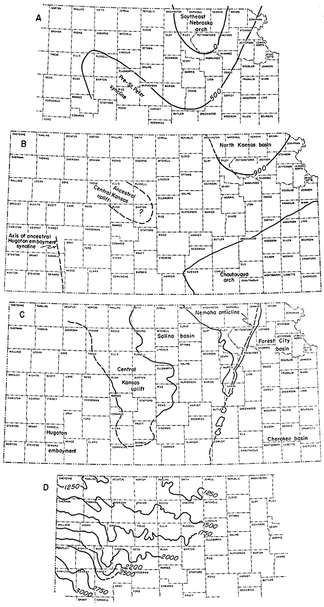
The major structural features of eastern and central Kansas are shown in Figure 2. Not all were developed contemporaneously. The structural features that were formed before the deposition of rocks of Simpson age are shown in Figure 2A. These are the Southeast Nebraska arch and a structural basin to the southwest. Some major structural features (Fig. 2B) were formed between St. Peter time and early Mississippian time. They include the Chautauqua arch, the Central Kansas uplift, and the North Kansas basin. The most prominent of the regional structural features formed between the end of Mississippian time and Middle Permian time (Fig. 2C) are the Nemaha anticline, the Forest City and Cherokee basins, the Salina basin, and the enlarged Central Kansas uplift. Several secondary folds parallel to the Nemaha anticline were also formed then. Figure 2D shows the present north dip of the Dakota formation, resulting from post-Cretaceous structural movement, which also reduced but did not reverse the south plunge of the Mississippian and older rocks in the Hugoton structural embayment.
Figure 2--Maps showing principal structural features of Kansas. A. Pre-Simpson structure represented by 500-foot thickness lines of Arbuckle dolomite and Reagan sandstone. B. Structural deformation from Arbuckle through Chattanooga time: (a) North Kansas basin outlined by 900-foot isopach, (b) Chautauqua arch, outlined by margin of Simpson rocks, (c) trend of Hugoton embayment (after Maher and Collins, 1949, sheet 1). C. Pattern of structural deformation from Chattanooga to middle Permian time, outlined by margin of Mississippian rocks. D. Post-Dakota deformation shown by 250-foot structure contours on the Dakota formation (after Lee and Merriam, 1954, pl. 2).
Terminology
The meanings intended for certain descriptive terms used in this report are listed below.
Cotton rock is a soft porous siliceous rock or insoluble residue composed of white opaque uncemented microscopic particles of silica.
Dolomold (Ireland, 1947) is a term for the impression left by a dolomite crystal removed from chert or other material in insoluble residues. Dolomolds may occur singly or so abundantly that they form a porous or spongy texture.
Drusy texture is a term applied to deposits of crystalline quartz formed in microscopic cavities.
Even-textured rock has a homogeneous character and is microscopically fine grained or dense.
Grainy texture denotes microscopic crystals of limestone or dolomite or particles of silt sparsely distributed in a dull, opaque, usually calcareous matrix. The matrix in some rocks is cryptocrystalline, in others earthy. With change in the character of the matrix, rocks having this texture grade into sucrose dolomite or silty limestone.
Hackly texture is a term applied to broken quartz without crystal faces.
Matted texture as applied to chert indicates closely packed fragments of silicified microfossils and sponge spicules cemented in a siliceous matrix.
Mottled is applied to parti-colored chert in patches Without sharp margins; it is microscopic, but much coarser than stippled.
Porous texture denotes aggregates of quartz, chert, or other materials in which the intervening individual cavities are microscopic.
Semigranular texture is applied to coarsely crystalline grains, principally fossil fragments, in a microcrystalline matrix. Some crinoidal limestone is semigranular.
Spongy texture refers to aggregates of quartz, chert, silt, or clay in insoluble residues from which soluble matrix has been removed. The individual openings are submicroscopic.
Stippled indicates a dotted pattern on a smoothly broken chert surface. It results from complete replacement by silica of rocks having grainy texture. The originally sharp outline of the replaced impurities in some zones is blurred, so the replaced particles show a cloudy margin.
Streaked texture indicates imperfectly replaced or subsequently modified matted chert containing microfossils. Outlines of the microfossil constituents are thus blurred.
Sucrose texture refers to microscopically coarse or fine crystals--usually dolomite--packed closely (without matrix) like the grains of lump sugar.
Acknowledgments
The most important contributions to this report were made by the Kansas Geological Society, whose foresighted officers acting through the Well Log Bureau have collected and made available the priceless collections of well logs, samples, and electric logs now on file in Wichita and Lawrence. Sample logs of the Kansas Sample Log Service, many of which were checked for detail, have been used freely. A good many samples of wells drilled before the establishment of the Well Log Bureau are in the files of the Geological Survey of Kansas. Data of various kinds were contributed to the original report by nearly every oil company in Wichita and Tulsa, and were acknowledged in the original report.
Sample logs by Constance Nieschmidt (nee Leatherock) and Theodore Botinelly prepared for the original bulletin have been invaluable in preparing the revision. Cross sections X-X' and Y-Y' (Pl. 11 and 12) by Botinelly are reproduced without alteration.
The writer also acknowledges helpful comment by Earl McCracken and Robert F. Walters, to whom the chapter on the Arbuckle rocks was submitted. Neither, however, approved or disapproved the theory advanced.
Prev Page--Contents || Next Page--Stratigraphy--Precambrian to Cambrian
Kansas Geological Survey, Geology
Placed on web Jan. 5, 2017; originally published Dec. 1956.
Comments to webadmin@kgs.ku.edu
The URL for this page is http://www.kgs.ku.edu/Publications/Bulletins/121/02_intro.html