 |
|
Kansas Geological Survey Open-file Report 2003-82 |
2.2 Distribution and Vertical Relationships of Facies
The Cherokee Group is composed of numerous repetitive successions of interbedded
gray to dark gray shale, rippled sandstone and siltstone, underclay, thin
coal, and thin argillaceous limestone. The following table lists a typical
succession starting with marine facies progressively transitioning to marginal
marine to non-marine facies (Table 2.2).
Table 2.2 – Distribution and vertical relationships of facies |
|||
Vertical Relationships |
|||
Lithofacies |
Distribution |
Underlying facies |
Overlying facies |
| Phosphatic black shale | Entire basin & into adjacent states | Coal or blocky mudstone | Dark gray shale |
| Dark Gray shale | Across basin & throughout Cherokee Group | Phosphatic black shale | Interlam. Ss & Xs, lam. muddy shale, bio wackestone or pyrite sh |
| Bioclastic-mudstone to -wackestone | Observed in upper Higginsville, Black Jack Creek & Breezy Hill limestones | Phosphatic black shale | Bioclastic-packstone-to-grainstone |
| Bioclastic-packstone-to-grainstone | Observed in upper Higginsville, Black Jack Creek & Breezy Hill limestones | Bioclastic-mudstone-to-wackestone | Blocky mudstone or phosphatic black shale |
| Interlam. Ss and Xs | Observed as fill above incision surfaces and discontinuous | Phosphatic black shale or dark gray shale | Coal, sideritic gray sh or poorly developed blocky mudstone |
| Sideritic gray shale | Observed as fill above incision surfaces and discontinuous | Interlaminated Ss & Xs | Blocky mudstone or laminated muddy sandstone |
| Laminated Muddy Ss | Observed in middle and upper Cherokee Group | Dark gray shale | Poorly developed blocky mudstone or coal |
| Pyritic black shale | Observed in Krebs Fm and in upper Cherokee Group | Dark gray shale or sideritic shale | Blocky mudstone or coal |
| Blocky mudstone | Throughout basin and Cherokee Group | Pyritic black shale, cross-lam. muddy Ss, interlam. Ss & Xs, or bio-packstone-to-wackestone | Coal of phospatic black shale |
Coal |
Highly variable across basin & throughout Cherokee Group | Blocky mudstone | Dark gray shale or phospatic black shale |
2.3 Coal Bearing Intervals of the Cherokee Group
Division of the Cherokee Group into ten intervals is based on regionally extensive marker beds, which serve to define mappable units. These marker beds are the black phosphatic shale lithofacies. Typically, the base of marker beds will be interpreted as flooding surfaces. The intervals also serve as a basis for identifying and mapping individual coals in the Cherokee Group. Coal thickness and distribution of individual coals can be related to the paleostructure reflected in the underlying units.
2.3.1 Mississippian Basement
In southeastern Kansas, Cherokee Group clastic rocks unconformably overly Mississippian limestones (Meremecian Stage; Merriam, 1963; Figure 2.13). The top of the Mississippian is characterized by a chert residue (Watney et al., 2001). Depth to the karstic Mississippian basement in the Cherokee basin ranges from 0 feet at outcrops in the extreme southeastern corner of Kansas, to more than 2500 feet (762 m) in Elk and Chautauqua counties, as the Mississippian and Cherokee Group rocks gradually dip to the west and southwest (Figure 2.14).
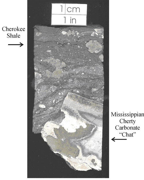 |
| Figure 2.13 - Polished core section showing the unconformable contact between the Mississippian and Middle Pennsylvanian. The Cherokee Group shale overlies the karstic Mississippian Warsaw Limestone (Meremecian) and chert residium ("chat"). Sample from 1,081' in the Hinthorn CW#1 well, 14-T32S-R16E, Montgomery County, Kansas |
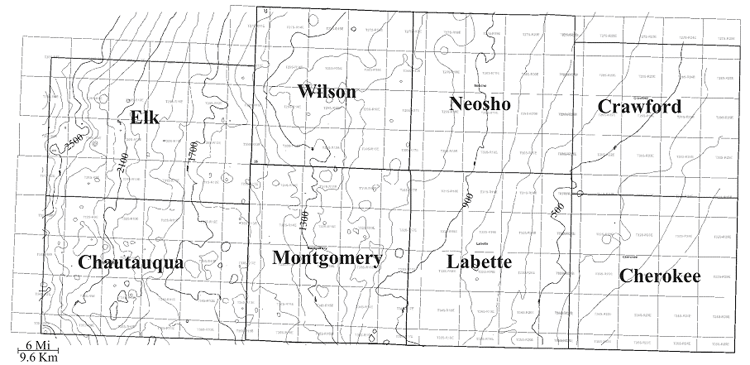 |
| Figure 2.14 - Structure map on top of the Mississippian limestone showing regional dip to the west (CI:100 ft). The surface is characterized by extensive karst features resulting in a highly irregular topography for deposition of the overlying Cherokee Group coal bearing intervals. |
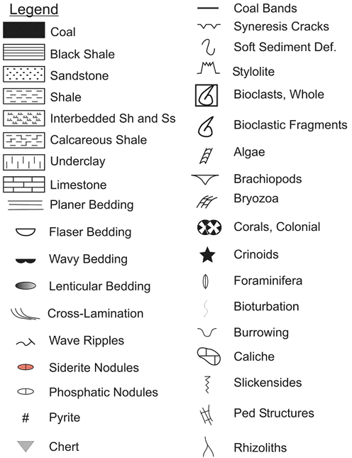 |
| Figure 2.15a - Symbols for depositional sequences in figures 2.15, 2.17, 2.20, 2.22, 2.24, 2.28 and 2.30 |
- 2.3.2 Riverton Interval and 2.3.3 A-B Interval
- 2.3.4 Bluejacket B Interval and 2.3.5 Weir-Pittsburg Interval
- 2.3.6 Tebo Interval
- 2.3.7 Scammon Interval
- 2.3.8 Mineral Interval and 2.3.9 V-Shale Interval
- 2.3.10 Bevier Interval and 2.3.11 Excello Interval
- 2.3.12 Little Osage Interval
e-mail : webadmin@kgs.ku.edu
Last updated December 2003
http://www.kgs.ku.edu/PRS/publication/2003/ofr2003-82/chapter202.html