 |
|
Kansas Geological Survey Open-file Report 2003-82 |
2.3.7 Scammon Interval
Description
The interval from the top of the Tebo shale to the top of the Scammon shale marker ranges in thickness from 8 to 80 feet with an average of 38 feet (2.4 to 24.4 m, average of 11.6 m; Figures 2.01 and 2.22). Variability in interval thickness may be due to thick sandstone accumulations within the interval (up to 40 ft, 12 m). In ascending order, the Scammon interval consists of a dark gray shale facies passing upward into interlaminated sandstone and siltstone facies known as the Skinner Sandstone or Chelsea Sandstone. A blocky mudstone facies, and the semi-continuous Scammon coal overlie the Skinner/Chelsea Sandstone. At the top of the Scammon interval is a dark gray shale facies (Figure 2.22). The bottom of the Skinner/Chelsea Sandstone is an unconformity that can erode deeply into the underlying interval (Tebo interval). Locally, a discontinuous coal facies (Scammon B coal) is present within the Skinner/Chelsea Sandstone.
Scammon Interval |
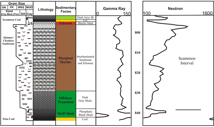 |
| Figure 2.22 - Depositional sequence and log characteristics of the Scammon interval, based on core and well log from the Hinthorn CW#1 well, 14-T32S-R16E, Montgomery County, Kansas (scale in feet). See Figure 2.15a for legend. |
Scammon Coal Isopach Map
The Scammon coal is recognizable on logs due to a relatively high gamma ray
response (> 105 API units) and low neutron response (< 475 neutron counts)
from the thin black shale marker followed down hole by a lower gamma ray response
(< 105 API units) associated with the underlying coal (Figure 2.22). The
Scammon shale marker extends across most of the Cherokee basin. Thickness
of the Scammon coal can be up to 3 feet with an average of 1 foot and distribution
slightly skewed to the minimum (1 m, average of 0.3 m; Figure 2.23; Appendix
2).
Detailed isopach mapping of the Scammon coal reveals a coal that remains fairly constant in thickness over an average of 6 square miles (9.6 km2; Figure 2.23). When structural contours of top of the Skinner Sandstone are overlain onto an isopach of the Scammon coal thickness, the coal appears to thicken on highs and thin into lows. Highs associated with the Skinner Sandstone may be due to differential compaction, where thicker Skinner Sandstone units provide a relatively higher topographic area. Local thin trends within thicker Scammon coal may be due to removal by fluvial erosion. The Scammon coal exhibits an irregular geometry that is oriented parallel and oblique to depositional dip (southwest), and is consistently thicker in Labette, Montgomery and Wilson counties
Scammon Coal |
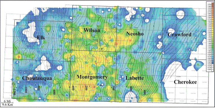 |
| Figure 2.23 - Isopach of Scammon Coal (color) overlain with contours of bottom Skinner/Chelsea Sandstone structure (isopach CI:0.10ft; structure CI:25ft). |
e-mail : webadmin@kgs.ku.edu
Last updated December 2003
http://www.kgs.ku.edu/PRS/publication/2003/ofr2003-82/chapter237.html