 |
|
Kansas Geological Survey Open-file Report 2003-82 |
2.3.2 Riverton Interval
Description
The interval from the top of the Mississippian to the top of the Riverton shale ranges in thickness from 4 to 40 feet with an average of 15 feet (1.2 to 12 m, 4.5 m; Figures 2.02 and 2.15). Variability in thickness is due to deposition of sediments on top of the high relief karstic Mississippian limestone. In ascending order, the Riverton interval consists of a pyritic shale facies and a blocky mudstone facies, which is overlain by the Riverton coal (Figure 2.15). The Riverton coal is capped by a phosphatic black shale facies (Figure 2.15). Locally, siltstone lenses, and additional coal beds are present below the Riverton coal. An additional blocky mudstone facies ranging in thickness from 1 to 3 feet (0.3 to 1 m) is locally found in the middle of the interval beneath the Riverton coal.
Riverton and Lower A-B Interval |
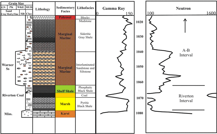 |
| Figure 2.15 - Depositional sequence and log characteristics of the Riverton and lower A-B interval, based on core and well log from the Hinthorn CW#1 well, 14-T32S-R16E, Montgomery County, Kansas (scale in feet). See Figure 2.15a for legend |
Riverton Isopach Map
The Riverton shale is recognizable on logs due to a relatively high gamma
ray response (approx. 110 API units) and low neutron response (< 400 neutron
counts) followed down hole by a lower gamma-ray response (< 105 API units)
associated with the underlying Riverton coal (Figure 2.15). The Riverton coal
is the first thick and laterally extensive coal bed encountered in the Cherokee
Group in southeastern Kansas (Figure 2.16). Thickness of the Riverton coal
can be up to 4.5 feet with an average of 1.8 feet and a normal distribution
(1.4 m, average of 0.5 m; Appendix 2).
Detailed isopach mapping of the Riverton coal reveals a coal that stays fairly consistent in thickness over an average distance of 5 square miles (8 km2). The Riverton coal locally appears to thicken into the Mississippian lows and thin onto the highs (Figure 2.16). The Riverton coal is consistently thicker in Montgomery, Labette, and Neosho counties, while its thins to the west and east in the study area.
Riverton Coal |
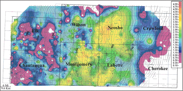 |
| Figure 2.16 - Isopach of Riverton coal (color) overlain with contours of top of Mississippian limestone structure (isopach CI: 0.10 ft; structure CI:25 ft). |
2.3.3 A-B Interval
Description
The interval from the top of the Riverton shale to the top of the A-B shale ranges in thickness from 22 to 112 feet with an average of 57 feet (6.7 to 34.1m, average of 17.4 m, Figure 2.01 and 2.15). Variability in interval thickness may be due to thick sandstone accumulations within the interval (up to 80 ft; 24 m). In ascending order, the A-B interval consists mainly of a dark gray shale facies, laterally discontinuous interlaminated sandstone and siltstone facies known as the Warner Sandstone, sideritic gray shale facies, and numerous discontinuous coal facies known informally as the Dw, Cw, and Bw (after Harris, 1984; Figure 2.15). The base of the Warner Sandstone is an unconformity. Due to the sporadic nature of coals distributed within the A-B interval, they were not mapped as part of this study. The A-B shale is recognizable on most well logs as the shale between the first split coal known as the Aw and Bw coals. When the coals are absent the A-B shale is approximately 25 feet (7.6 m) above the Warner Sandstone.
e-mail : webadmin@kgs.ku.edu
Last updated December 2003
http://www.kgs.ku.edu/PRS/publication/2003/ofr2003-82/chapter232-3.html