 |
|
Kansas Geological Survey Open-file Report 2003-82 |
2.3.4 Bluejacket B Interval
Description
The Bluejacket B interval extends from the top of the A-B shale to the top of the Bluejacket B shale and ranges in thickness from 20 to 200 feet (6.1 to 59 m; Figures 2.01 and 2.17; Staton, 1987). Variability in interval thickness is the result of thick sandstone accumulations (up to 60 ft, 18 m). In ascending order, the Bluejacket B interval consists of a widely distributed dark gray shale facies, pyritic shale facies, coal facies, and erratically distributed sideritic shale facies. Continuing upward is an interlaminated sandstone and siltstone facies known as the Warner (upper), Bluejacket or Bartlesville sandstones. The sandstone is overlain by the Weir - Pittsburg B coal (lower Weir-Pitt coal; Figure 2.17). The base of the Warner Sandstone (upper) and Bluejacket/Bartlesville Sandstone is an unconformity.
Weir-Pittsburg and Upper Bluejacket B Interval |
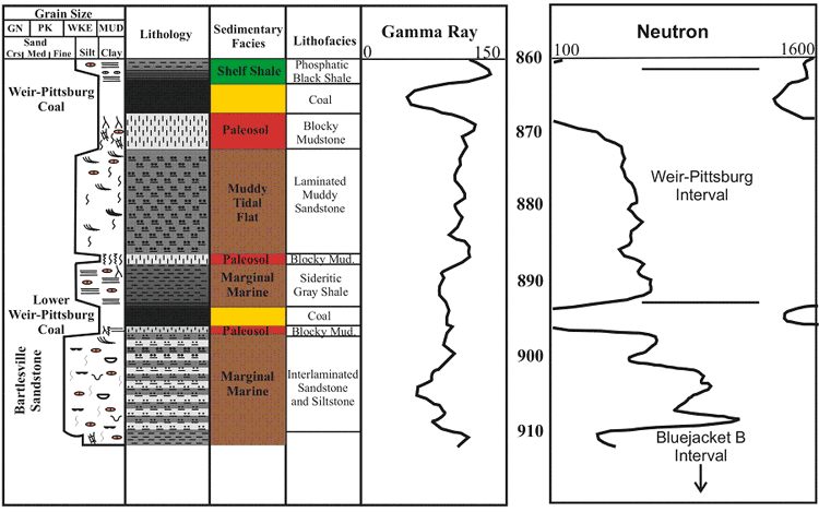 |
| Figure 2.17 - Depositional sequence and log characteristics of the Weir-Pittsburg and upper Bluejacket B interval, based on core and well log from the Hinthorn CW#1 well, 14-T32S-R16E, Montgomery County, Kansas (scale in feet). See Figure 2.15a for legend. |
Laterally continuous coal beds known as the Aw, Neutral, Rowe and Dry Wood
are sporadically distributed throughout the Cherokee basin. The informally
named Bbj,
Cbj, and Dbj coal beds are also distributed throughout the Cherokee basin,
but are very difficult to correlate over any distance.
Aw Isopach Map
The Aw coal is recognizable on most logs due to its close stratigraphic relationship
with the underlying thin Bw coal. Approximately 4 feet of shale separate the
coals (1.2 m). Thickness of the Aw coal can be up to 4 feet with an average
of 1.7 feet and a slightly skewed distribution to the maximum (1.2 m, average
of 0.5 m; Appendix 2). The Aw coal is recognizable on most logs in the central
part of the Cherokee basin as the next thick coal above the Warner Sandstone
(Figure 2.18). Due to the lack of Aw coal in any of the described cores, this
study does not include a depositional sequence for the Aw coal.
Detailed isopach mapping of the Aw coal reveals a coal that stays fairly consistent in thickness over an average of 3 square miles (4.8 km2; Figure 2.18). When bottom contours of Aw coal structure are overlain on the isopach map, the coal appears to thicken onto local highs and thin into lows. The Aw coal exhibits an elongate geometry that is oriented parallel to depositional dip (SW), and is consistently thicker within a north-south trend through Montgomery, Wilson, and Neosho counties. Locally thin areas and linear trends in the Aw coal thickness may be due to removal by erosion (ie. channel erosion).
Aw Coal |
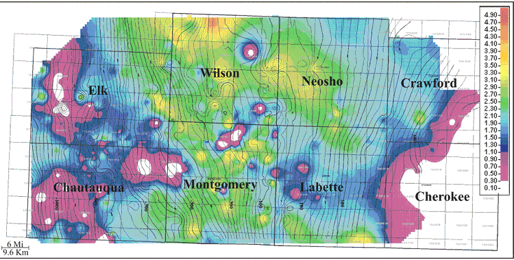 |
| Figure 2.18 - Isopach of Aw coal (color) overlain with countours of bottom Aw coal structure (isopach CI: 0.10ft; structure CI: 25ft). |
2.3.5 Weir-Pittsburg Interval
Description
The interval from the top of the Bluejacket B Shale to the top of the Weir-Pittsburg shale ranges in thickness from 5 to 60 feet with an average of 20 feet (1.5 to 18.2 m, average of 6.1 m; Figures 2.01 and 2.17). In ascending order, the Weir-Pittsburg interval consists mainly of a sideritic shale facies that passes upward into a laminated muddy sandstone facies or interlaminated sandstone and shale facies. These facies are overlain by a blocky mudstone facies followed up section by the Weir-Pittsburg coal, and capped by a dark gray shale facies (Figure 2.17). Poorly developed blocky mudstone facies can occur locally through the Weir-Pittsburg interval.
Weir-Pittsburg Coal Isopach Map
The Weir-Pittsburg coal is recognizable on logs due to a relatively high gamma
ray response (> 120 API units) and low neutron response (< 200 neutron
counts) from the Weir-Pittsburg shale followed down hole by a lower gamma
ray response (< 75 API units) associated with the underlying Weir-Pittsburg
coal (Figure 2.17). Thickness of the Weir-Pittsburg coal can be up to 6 feet
with an average of 1.5 feet and distribution skewed to the minimum (1.8 m,
average of 0.5 m; Appendix 2). The Weir-Pittsburg coal is recognizable on
logs in the central part of the Cherokee basin as the thickest coal in the
Cherokee Group (Figure 2.19). Of the many coals mined in the outcrop belt,
the Weir-Pittsburg coal is known to be the thickest and best developed coal
(Brady, 1997).
Weir-Pittsburg Coal |
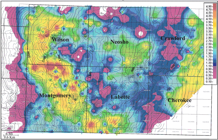 |
| Figure 2.19 - Isopach of Weir-Pittsburg coal (color) overlain with contours of top Mississippian limestone structure (isopach CI:0.10ft; structure CI:25ft). |
Detailed isopach mapping of the Weir-Pittsburg coal reveals a coal that stays fairly consistent in thickness over an average of 2.5 square miles (4 km2; Figure 2.19). When overlaying contours of top Mississippian structure on the isopach map, the coal appears to follow the structural strike. The Weir-Pittsburg coal exhibits a lenticular geometry that is oriented parallel to depositional strike (northwest), and is consistently thicker through an acute trend from southern Labette through Montgomery and Wilson counties. Localized circular areas of the Weir-Pittsburg coal may be due to removal by fire or crevasse splays (see Chapter 5).
e-mail : webadmin@kgs.ku.edu
Last updated December 2003
http://www.kgs.ku.edu/PRS/publication/2003/ofr2003-82/chapter234-5.html