 |
|
Kansas Geological Survey Open-file Report 2003-82 |
2.3.12 Little Osage Interval
Description
The Little Osage interval extends from the top of the Excello Shale to the top of the Little Osage Shale and ranges in thickness from 10 to 45 feet with a mode of 20 feet (3 to 13.7 m, average of 6 m; Figures 2.01 and 2.30). The Little Osage interval consists of a regionally extensive bioclastic wackestone facies that grades into a bioclastic packstone/grainstone facies known as the Blackjack Creek Limestone. Above the Blackjack Creek Limestone is a coal to carbonaceous shale facies known as the Summit coal that is overlain by regionally extensive phosphatic black shale known as the Little Osage Shale (Figure 2.30).
The Little Osage Shale is a highly radioactive phosphatic black shale in the Fort Scott Limestone Formation that extends throughout the Cherokee basin and into adjacent states. It separates the Higginsville Limestone from the Blackjack Creek Limestone and is recognizable on logs due to a high gamma ray response (> 225 API units) and low neutron response (< 200 neutron counts) followed down the hole by a lower gamma ray response (< 150 API units) and low neutron response (< 100 neutron counts) associated with the underlying coal or carbonaceous shale known as the Summit coal (Figure 2.30).
Little Osage and Upper Excello Interval |
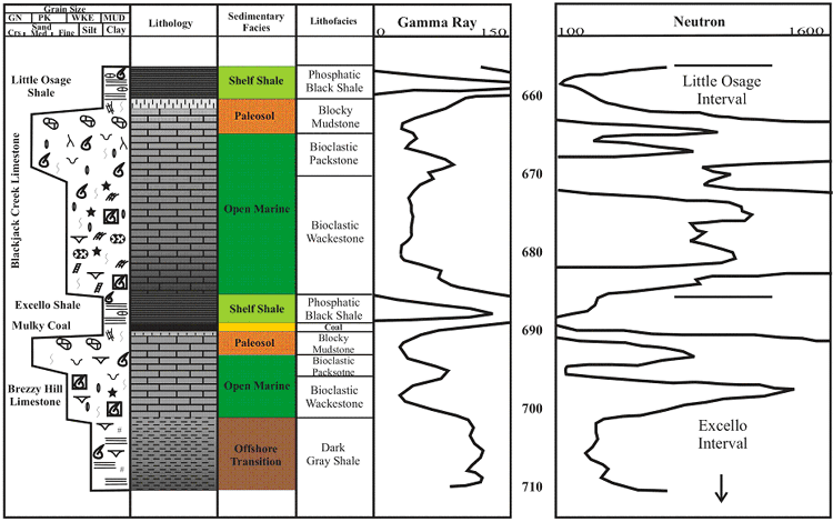 |
| Figure 2.30 - Depositional sequence and log characteristics of the Little Osage and Upper Excello interval, based on core and well log from the Hinthorn CW#1 well, 14-T32S-R16E, Montgomery County, Kansas (scale in feet). See Figure 2.15a for legend. |
Summit Coal Isopach Map
Detailed isopach mapping of the Summit coal reveals a coal that has a consistency
in thickness over an average of 6 square miles (9.6 km2; Figure 2.33). Thickness
of the Summit coal can be up to 2.8 feet with an average of 1 foot and a distribution
that is slightly skewed to the minimum (0.9 m, average of 0.3 m; Appendix
2)). The Summit coal exhibits an irregular circular to polygonal geometry.
Structure appears to have an influence on coal thickness. When overlying contours
of top Blackjack Creek Limestone structure onto an isopach of Summit coal
thickness, the coal usually to thickens on the highs and thin into lows. The
Summit coal is consistently thicker in Neosho County. Areas and trends of
thin Summit coal thickness may be due to non-deposition or deposition of carbonaceous
shale instead of coal.
Summit Coal |
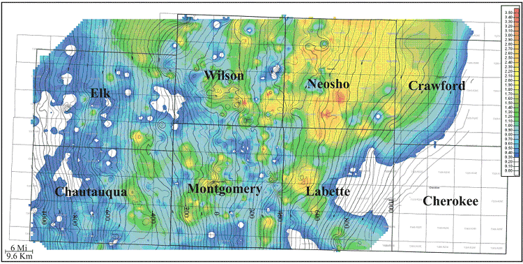 |
| Figure 2.33 - Isopach of Summit Coal (color) overlain with contours of top Blackjack Creek Limestone structure (isopach CI:0.10ft; structure CI:25ft). |
e-mail : webadmin@kgs.ku.edu
Last updated December 2003
http://www.kgs.ku.edu/PRS/publication/2003/ofr2003-82/chapter2312.html