 |
|
Kansas Geological Survey Open-file Report 2003-82 |
2.3.6 Tebo Interval
Description
The interval from the top of the Weir-Pittsburg shale to the top of the Tebo shale ranges in thickness from 6 to 50 feet with an average of 25 feet (1.8 to 15.6m, average of 7.7 m; Figures 2.01 and 2.20). In ascending order, the Tebo interval consists of a dark gray shale facies passing upward into a laminated muddy sandstone facies. Overlying these facies is a regional coal facies (Tebo coal), capped by a phosphatic black shale facies (Figure 2.20). A poorly developed blocky mudstone facies locally underlies the Tebo coal.
Tebo Interval |
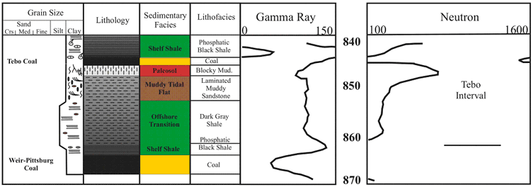 |
| Figure 2.20 - Depositional sequence and log characteristics of the Tebo interval, based on core and well log from the Hinthorn CW#1 well, 14-T32S-R16E, Montgomery County, Kansas (scale in feet). See Figure 2.15a for legend. |
Tebo Coal Isopach Map
The Tebo coal is recognizable on logs due to a high gamma ray response (>
160 API units) and low neutron response (< 625 neutron counts) from the
thick radioactive phosphatic black shale marker, which is followed down hole
by a lower gamma ray response (< 105 API units) associated with the underlying
Tebo coal (Figure 2.21). The Tebo shale marker extends across the Cherokee
basin. Thickness of the Tebo coal can be up to 3 feet with an average of 0.9
feet and a distribution slightly skewed to the minimum (1 m, average of 0.3
m; Figure 2.21; Appendix 2).
Detailed isopach mapping of the Tebo coal reveals a coal that stays fairly consistent in thickness over an average of 5 square miles (8 km2; Figure 2.21). Structural contours of bottom of the Tebo coal are overlain on an isopach of the Tebo coal (Figure 2.21). The coal appears to thicken on highs and thin into lows. The Tebo coal exhibits an elongate geometry oriented obliquely to depositional dip (southwest) and strike (northwest) with an area of thicker accumulation through Montgomery and Wilson counties. Local thin areas and linear trends in the Tebo coal thickness may be the consequence of erosion (i.e. fluvial).
Tebo Coal |
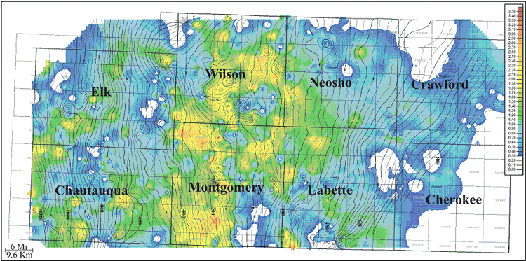 |
| Figure 2.21 - Isopach of Tebo Coal (color) overlain with contours of bottom Tebo Coal structure (isopach CI:0.10ft; structure CI:25ft). |
e-mail : webadmin@kgs.ku.edu
Last updated December 2003
http://www.kgs.ku.edu/PRS/publication/2003/ofr2003-82/chapter236.html