Prev Page--Contents || Next Page--Water-Quality Data
Introduction
The City of Beloit diverts water from the Solomon River for its municipal supply. During low flows, the river water can sometimes become slightly saline and exceed the secondary drinking water limits of 250 mg/L for both chloride and sulfate concentrations. The City has a right for accumulating water in Waconda Lake that could be released to reduce the salinity of the Solomon River water at Beloit if the chloride content exceeds the secondary drinking water limit. An agreement between the City and the State of Kansas for possible lake water release was prepared when Glen Elder Dam was constructed to alleviate any adverse impact of the dam on the river water supply. The Division of Water Resources (DWR) has a Memorandum of Understanding with the U.S. Bureau of Reclamation (USBR) that describes the procedure for requesting releases of water from Waconda Lake. The DWR needs to know the minimum amount of flow that can be released from the lake to achieve usable water quality while maximizing conservation of lake water, especially during periods of low inflows to the lake. The Kansas Department of Health and Environment (KDHE) needs information on sources, their relative contributions, and spatial and temporal variability of chloride and sulfate concentrations in stream segments as a part of the TMDL (total maximum daily load) program under Section 303d of the Clean Water Act. The objectives of this study were to 1) determine sources, variability, and flow relationships of chloride and sulfate in Solomon River waters entering and released from Waconda Lake and used by Beloit for public water supply, and 2) apply these relationships to develop a procedure for determining the flow releases from the lake necessary to dilute the chloride concentration below a threshold for the Beloit public water supply when mixed with low river flows.
Study Area
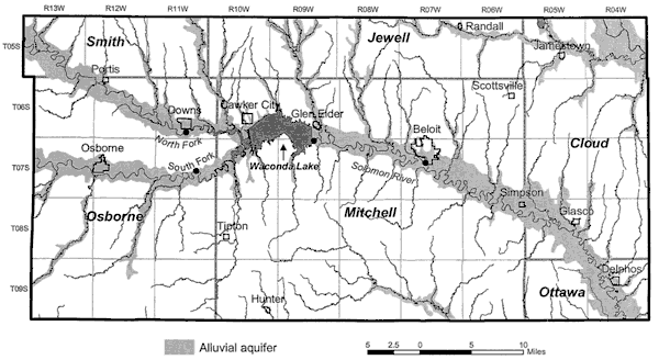
The study area includes the lower part of the watershed of the North Fork Solomon River in northeastern Osborne County and southeast Smith County, the lower part of the watershed of the South Fork Solomon River in east-central Osborne County, Waconda Lake in northwest Mitchell County, and the Solomon River through Mitchell County down to the southwestern comer of Cloud County. The western extent of the study area is defined as the U.S. Geological Survey (USGS) gaging stations at Portis and Osborne along Highway 281 and the eastern extent is to the Kansas Department of Health and Environment station for water-quality monitoring on the Solomon River near Glasco (Figure 1).
Figure 1. Map of the study area with sampling loctions. The study area includes the North Fork Solomon River from Portis and the South Fork Solomon River from Osborne downstream to the Solomon River near Glasco. The locations where water samples were collected by the Division of Water Resources and Kansas Geological Survey (KGS) and analyzed by the KGS are shown as solid circles on the North Fork at Downs and on the South Fork south of Downs (near Corinth), at Glen Elder Dam, and at Beloit. A larger version of this figure is available.
Prev Page--Contents || Next Page--Water-Quality Data
Kansas Geological Survey, Geohydrology
Comments to webadmin@kgs.ku.edu
Placed online Jan. 17, 2006
URL=http://www.kgs.ku.edu/Hydro/Publications/2003/OFR03_49/02_intro.html
