![]()
Prev Page--Introduction || Next Page--Data Analysis
Water-Quality Data
USGS and KDHE Data
The U.S. Geological Survey (USGS) and the Kansas Department of Health and Environment have collected water-quality data for the North and South forks Solomon River upstream of Waconda Lake, Waconda Lake, and the Solomon River downstream of Glen Elder Dam and near Glasco. Table 1 lists the station numbers, locations, and years of available data. In addition to the stations in Table 1, the USGS measures specific conductance periodically at the flow gaging stations but no longer collects water samples on a routine basis for chemical analysis at any of the stations within the study area. Thus, specific conductance data are available for the North Fork Solomon River at Portis, the South Fork Solomon River near Osborne, the Solomon River near Glen Elder, and the Solomon River near Simpson just east of the Mitchell-Cloud county line. The KGS assembled the data for Table 1 into an Excel spreadsheet with a worksheet for each site. Where the water-quality site coincides with a USGS streamflow gaging station, the flow data for the dates of water samples are included in the spreadsheet.
Table 1. Water-quality stations of the USGS and KDHE for surface waters in the study area. The data periods are for records with chloride and sulfate concentration data.
| Surface water body | Location | Agency | Station No. | Data period |
|---|---|---|---|---|
| North Fork Solomon watershed | ||||
| North Fork Solomon River | At Portis | USGS | 6872500 | 1961-1996 |
| North Fork Solomon River | At Portis | KDHE | 1709 | 1972 & 1974 |
| North Fork Solomon River | At Portis | KDHE | 014 | 1975-2003 |
| Twelvemile Creek | Near Downs | KDHE | 674 | 1993-2001 |
| Oak Creek | Near Cawker City | USGS | 06872700 | 1962-1970 |
| Oak Creek | Near Cawker City | KDHE | 544 | 1990-2003 |
| South Fork Solomon watershed | ||||
| South Fork Solomon River | At Osborne | USGS | 6874000 | 1961-1994 |
| South Fork Solomon River | At Osborne | KDHE | 1710 | 1972 & 1974 |
| South Fork Solomon River | At Osborne | KDHE | 015 | 1975-1989 |
| South Fork Solomon River | Below Osborne | KDHE | 543 | 1990-2003 |
| Twin Creek | Near Corinth | KDHE | 668 | 1992-2000 |
| Carr Creek | Near Cawker City | KDHE | 669 | 1992-2000 |
| Waconda Lake and Solomon River watershed downstream of Glen Elder Dam | ||||
| Waconda Lake | KDHE | 18001-18005 | 1977-2001 | |
| Limestone Creek | At Glen Elder | USGS | 6875800 | 1962-1970 |
| Limestone Creek | At Glen Elder | KDHE | 667 | 1991-2001 |
| Solomon River | Near Glen Elder | USGS | 6875900 | 1963-1983 |
| Solomon River | Near Glen Elder | KDHE | 089 | 1975-1998 |
| Solomon River | At Beloit | USGS | 6876000 | 1948-1965 |
| Solomon River | At Beloit | KDHE | 1708 | 1972 & 1974 |
| Solomon River | Near Glasco | KDHE | 511 | 1990-2003 |
Data Collected during the Study
The study included sampling and analysis of river and dam outlet waters to provide supplemental data needed to better characterize the quality of water entering and leaving Waconda Lake and to assess the data quality of analyses obtained by the City of Beloit for the Solomon River supply. The sampling locations selected for the inflow to Waconda Lake were the North Fork Solomon River at the Highway 181 bridge south of Downs and the South Fork Solomon River at the low-water bridge located 1 mile east and 1 and 1/4 miles north of Corinth. The sampling location of the South Fork Solomon River was downstream of the confluence of Twin Creek, which enters the river downstream of the Highway 181 bridge north of Corinth. The outflow sampling site for Waconda Reservoir was located on the south side of the river at the end of the outflow structure just downstream of Glen Elder Dam. Water samples from the Solomon River at Beloit were from the raw water line of the City. A total of 12 samples were collected monthly at each site during the course of one-year. Billinger of the DWR collected 11 of the sample sets (or obtained a sample that the City of Beloit collected from their raw water supply) and Whittemore of the KGS collected one sample set. Whittemore also collected a water sample from the Solomon River a couple miles upstream of Beloit, and directly from the river at the low-head dam near where the City raw water line takes water from the river during the same hour in which the raw water line in the water plant was sampled.
The samples were taken or shipped to the KGS for analysis. The KGS analyzed all of the water samples for specific conductance and chloride and sulfate concentrations. The analyses have a high level of accuracy based on the careful attention given to optimizing the instrumental analysis conditions for the samples and other quality assurance and quality control procedures. The KGS laboratory participates in the USGS Analytical Evaluation Program for Standard Reference Samples each year, and has consistently had high agreement of its analytical results with the averages of those published for the reference waters based on the analyses of many selected laboratories in the U.S. that participate in the program. The estimated maximum errors in the accuracy of specific conductance, and chloride and sulfate concentrations are 2%, 3%, and 4%, respectively. The sample collection data and chemical results are listed in Table 2.
Table 2. Location and collection information and chemical data for water samples collected for the study.
| KGS no. |
Project no. |
Sample location | Sample source | Descriptive location |
Sample date |
Sample time |
Sp.C. μS/cm |
Cl mg/L |
SO4 mg/L |
SO4/Cl ratio |
|---|---|---|---|---|---|---|---|---|---|---|
| 020188 | SOL-001 | 06-11W-34BBBC | N Fork Solomon R | At Downs | 5/21/02 | 16:10 | 1185 | 78.2 | 241 | 3.08 |
| 020192 | SOL-005 | 06-11W-34BBBC | N Fork Solomon R | At Downs | 6/12/02 | 15:45 | 1160 | 71.4 | 228 | 3.19 |
| 020222 | SOL-009 | 06-11W-34BBBC | N Fork Solomon R | At Downs | 7/18/02 | 14:07 | 1045 | 65.5 | 211 | 3.22 |
| 020260 | SOL-015 | 06-11W-34BBBC | N Fork Solomon R | At Downs | 8/13/02 | 15:15 | 860 | 53.7 | 173 | 3.22 |
| 020264 | SOL-019 | 06-11W-34BBBC | N Fork Solomon R | At Downs | 9/12/02 | 13:45 | 1080 | 63.0 | 231 | 3.67 |
| 020275 | SOL-023 | 06-11W-34BBBC | N Fork Solomon R | At Downs | 10/28/02 | 10:10 | 1090 | 60.6 | 212 | 3.50 |
| 020279 | SOL-027 | 06-11W-34BBBC | N Fork Solomon R | At Downs | 11/22/02 | 11:01 | 1170 | 64.9 | 231 | 3.56 |
| 030000 | SOL-031 | 06-11W-34BBBC | N Fork Solomon R | At Downs | 12/30/02 | 12:30 | 1160 | 69.0 | 226 | 3.28 |
| 030020 | SOL-035 | 06-11W-34BBBC | N Fork Solomon R | At Downs | 1/31/03 | 13:53 | 1040 | 59.9 | 209 | 3.49 |
| 030024 | SOL-039 | 06-11W-34BBBC | N Fork Solomon R | At Downs | 2/20/03 | 10:06 | 1115 | 69.0 | 225 | 3.26 |
| 030051 | SOL-043 | 06-11W-34BBBC | N Fork Solomon R | At Downs | 3/25/03 | 11:31 | 1085 | 72.4 | 208 | 2.87 |
| 030055 | SOL-047 | 06-11W-34BBBC | N Fork Solomon R | At Downs | 4/16/03 | 11:20 | 1075 | 69.9 | 202 | 2.89 |
| 020189 | SOL-010 | 07-11W-22ADAD | S Fork Solomon R | Near Corinth | 5/21/02 | 16:30 | 1495 | 138 | 328 | 2.38 |
| 020193 | SOL-024 | 07-11W-22ADAD | S Fork Solomon R | Near Corinth | 6/12/02 | 16:00 | 1345 | 128 | 307 | 2.40 |
| 020223 | SOL-028 | 07-11W-22ADAD | S Fork Solomon R | Near Corinth | 7/18/02 | 14:20 | 1340 | 131 | 310 | 2.37 |
| 020261 | SOL-032 | 07-11W-22ADAD | S Fork Solomon R | Near Corinth | 8/13/02 | 15:25 | 1140 | 107 | 284 | 2.65 |
| 020265 | SOL-036 | 07-11W-22ADAD | S Fork Solomon R | Near Corinth | 9/12/02 | 14:00 | 1380 | 128 | 330 | 2.58 |
| 020276 | SOL-040 | 07-11W-22ADAD | S Fork Solomon R | Near Corinth | 10/28/02 | 9:58 | 1340 | 111 | 272 | 2.45 |
| 020280 | SOL-044 | 07-11W-22ADAD | S Fork Solomon R | Near Corinth | 11/22/02 | 11:15 | 1410 | 122 | 315 | 2.58 |
| 030001 | SOL-048 | 07-11W-22ADAD | S Fork Solomon R | Near Corinth | 12/30/02 | 12:50 | 1400 | 119 | 303 | 2.55 |
| 030021 | SOL-002 | 07-11W-22ADAD | S Fork Solomon R | Near Corinth | 1/31/03 | 14:10 | 1245 | 113 | 266 | 2.35 |
| 030025 | SOL-006 | 07-11W-22ADAD | S Fork Solomon R | Near Corinth | 2/20/03 | 9:35 | 1440 | 131 | 327 | 2.50 |
| 030052 | SOL-016 | 07-11W-22ADAD | S Fork Solomon R | Near Corinth | 3/25/03 | 11:23 | 1550 | 152 | 309 | 2.03 |
| 030056 | SOL-020 | 07-11W-22ADAD | S Fork Solomon R | Near Corinth | 4/16/03 | 11:00 | 1370 | 122 | 302 | 2.48 |
| 020190 | SOL-003 | 06-09W-27CDCA | Solomon River | Glen Elder Dam | 5/21/02 | 15:30 | 1120 | 98.1 | 265 | 2.70 |
| 020194 | SOL-007 | 06-09W-27CDCA | Solomon River | Glen Elder Dam | 6/12/02 | 15:15 | 1115 | 101 | 277 | 2.74 |
| 020224 | SOL-011 | 06-09W-27CDCA | Solomon River | Glen Elder Dam | 7/18/02 | 16:36 | 1100 | 101 | 267 | 2.64 |
| 020262 | SOL-017 | 06-09W-27CDCA | Solomon River | Glen Elder Dam | 8/13/02 | 14:40 | 1090 | 100 | 272 | 2.72 |
| 020266 | SOL-021 | 06-09W-27CDCA | Solomon River | Glen Elder Dam | 9/12/02 | 13:15 | 1105 | 107 | 288 | 2.69 |
| 020277 | SOL-025 | 06-09W-27CDCA | Solomon River | Glen Elder Dam | 10/28/02 | 10:38 | 1150 | 110 | 278 | 2.53 |
| 020281 | SOL-029 | 06-09W-27CDCA | Solomon River | Glen Elder Dam | 11/22/02 | 12:02 | 1150 | 112 | 295 | 2.63 |
| 030002 | SOL-033 | 06-09W-27CDCA | Solomon River | Glen Elder Dam | 12/30/02 | 13:30 | 1150 | 109 | 285 | 2.61 |
| 030022 | SOL-037 | 06-09W-27CDCA | Solomon River | Glen Elder Dam | 1/31/03 | 14:48 | 1180 | 112 | 304 | 2.71 |
| 030026 | SOL-041 | 06-09W-27CDCA | Solomon River | Glen Elder Dam | 2/20/03 | 10:33 | 1160 | 112 | 303 | 2.71 |
| 030053 | SOL-045 | 06-09W-27CDCA | Solomon River | Glen Elder Dam | 3/25/03 | 11:57 | 1170 | 108 | 277 | 2.56 |
| 030057 | SOL-049 | 06-09W-27CDCA | Solomon River | Glen Elder Dam | 4/16/03 | 11:45 | 1175 | 111 | 293 | 2.64 |
| 020225 | SOL-012 | 07-08W-12DAAA | Solomon River | 2 mi west of Beloit | 7/18/02 | 16:05 | 1115 | 103 | 267 | 2.59 |
| 020191 | SOL-004 | 07-07W-09CBAC | Solomon River | Beloit water plant | 5/21/02 | 13:15 | 1475 | 179 | 275 | 1.54 |
| 020195 | SOL-008 | 07-07W-09CBAC | Solomon River | Beloit water plant | 6/12/02 | 14:00 | 1225 | 128 | 280 | 2.19 |
| 020226 | SOL-013 | 07-07W-09CACC | Solomon River | River at Beloit intake | 7/18/02 | 15:45 | 1205 | 122 | 274 | 2.25 |
| 020227 | SOL-014 | 07-07W-09CBAC | Solomon River | Beloit water plant | 7/18/02 | 15:32 | 1205 | 121 | 274 | 2.26 |
| 020263 | SOL-018 | 07-07W-09CBAC | Solomon River | Beloit water plant | 8/13/02 | 10:00 | 1130 | 119 | 272 | 2.29 |
| 020267 | SOL-022 | 07-07W-09CBAC | Solomon River | Beloit water plant | 9/12/02 | 9:00 | 1285 | 144 | 303 | 2.10 |
| 020278 | SOL-026 | 07-07W-09CBAC | Solomon River | Beloit water plant | 10/28/02 | 1360 | 163 | 263 | 1.61 | |
| 020282 | SOL-030 | 07-07W-09CBAC | Solomon River | Beloit water plant | 11/22/02 | 1475 | 179 | 304 | 1.70 | |
| 030003 | SOL-034 | 07-07W-09CBAC | Solomon River | Beloit water plant | 12/30/02 | 10:00 | 1550 | 196 | 310 | 1.58 |
| 030023 | SOL-038 | 07-07W-09CBAC | Solomon River | Beloit water plant | 1/31/03 | 11:30 | 1460 | 181 | 302 | 1.67 |
| 030027 | SOL-042 | 07-07W-09CBAC | Solomon River | Beloit water plant | 2/20/03 | 10:00 | 1500 | 192 | 310 | 1.61 |
| 030054 | SOL-046 | 07-07W-09CBAC | Solomon River | Beloit water plant | 3/25/03 | 10:00 | 1480 | 175 | 283 | 1.62 |
| 030058 | SOL-050 | 07-07W-09CBAC | Solomon River | Beloit water plant | 4/16/03 | 9:30 | 1500 | 186 | 301 | 1.62 |
The sample taken from the raw water line in the Beloit water plant at 3:32 pm and the sample collected directly from the Solomon River near the water intake pipe of the city at 3:45 pm on July 18, 2002 had the same specific conductance and sulfate values. The chloride measurements differed by only 1 mg/L or less than 1% of the value. This confirmed that there was no change in these parameters during the travel from the river to the water plant. Therefore, sampling from the raw water line in the water plant was considered as representative of the river water.
City of Beloit Data
The City of Beloit measures the chloride concentration daily and the sulfate content weekly in the raw water supply from the Solomon River. The DWR obtained these data from the City for the period 1988-2003, assembled them into a spreadsheet, and sent them to the KGS for use in the study. The KGS assessed the accuracy of the data by comparing the KGS analyses (see section below) with the City measurements. Table 3 lists the KGS and Beloit chloride and sulfate concentration measurements and ratios along with the flow of the Solomon River below Glen Elder Dam. The Beloit sulfate determination closest in time to the KGS measurement is listed in the table. The flow of the Solomon River below Glen Elder Dam is also included for the dates of the period of sample analyses and one day previous to the earliest date of analysis to account for the approximate flow time from the USGS gaging station to Beloit.
Table 3. Comparison of KGS and City of Beloit measurements of chloride and sulfate concentrations during 2002-2003. Flow at USGS gaging station below Glen Elder Dam.
| Date | Flow ft3/sec |
KGS Cl mg/L |
Beloit Cl mg/L |
Beloit Cl/ KGS Cl |
KGS SO4 mg/L |
Beloit SO4 mg/L |
Beloit SO4/ KGS SO4 |
KGS SO4/Cl |
Beloit SO4/Cl |
|---|---|---|---|---|---|---|---|---|---|
| 5/19/02 | 19 | 220 | |||||||
| 5/20/02 | 19 | 220 | 275 | 1.25 | |||||
| 5/21/02 | 18 | 179 | 218 | 1.22 | 275 | 1.00 | 1.54 | ||
| 6/9/02 | 53 | 186 | |||||||
| 6/10/02 | 46 | 158 | 387 | 2.45 | |||||
| 6/11/02 | 35 | 154 | |||||||
| 6/12/02 | 30 | 128 | 158 | 1.23 | 280 | 1.38 | 2.19 | ||
| 7/14/02 | 121 | 142 | |||||||
| 7/15/02 | 119 | 146 | 265 | 1.82 | |||||
| 7/16/02 | 118 | 140 | |||||||
| 7/17/02 | 119 | 154 | |||||||
| 7/18/02 | 129 | 121 | 152 | 1.26 | 274 | 0.97 | 2.26 | ||
| 8/11/02 | 96 | 152 | |||||||
| 8/12/02 | 91 | 150 | 231 | 1.54 | |||||
| 8/13/02 | 74 | 119 | 148 | 1.24 | 272 | 0.85 | 2.29 | ||
| 9/8/02 | 46 | 182 | |||||||
| 9/9/02 | 46 | 190 | 227 | 1.19 | |||||
| 9/10/02 | 46 | 162 | |||||||
| 9/11/02 | 40 | 178 | |||||||
| 9/12/02 | 33 | 144 | 160 | 1.11 | 303 | 0.75 | 2.10 | ||
| 10/27/02 | 17 | 274 | |||||||
| 10/28/02 | 17 | 163 | 210 | 1.29 | 263 | 385 | 1.46 | 1.61 | 1.83 |
| 11/21/02 | 17 | 232 | |||||||
| 11/22/02 | 17 | 179 | 210 | 1.17 | 304 | 0.96 | 1.70 | ||
| 11/23/02 | 17 | 212 | |||||||
| 11/24/02 | 17 | 222 | |||||||
| 11/25/02 | 17 | 220 | 293 | 1.33 | |||||
| 12/29/02 | 15 | 260 | |||||||
| 12/30/02 | 15 | 196 | 232 | 1.18 | 310 | 376 | 1.21 | 1.58 | 1.62 |
| 1/30/03 | 15 | 228 | |||||||
| 1/31/03 | 15 | 181 | 226 | 1.25 | 302 | 1.16 | 1.67 | ||
| 2/1/03 | 15 | 186 | |||||||
| 2/2/03 | 15 | 194 | |||||||
| 2/3/03 | 16 | 186 | 350 | 1.88 | |||||
| 2/16/03 | 17 | 216 | |||||||
| 2/17/03 | 17 | 222 | 358 | 1.61 | |||||
| 2/18/03 | 18 | 216 | |||||||
| 2/19/03 | 17 | 224 | |||||||
| 2/20/03 | 17 | 192 | 222 | 1.16 | 310 | 1.15 | 1.61 | ||
| 3/23/03 | 17 | 230 | |||||||
| 3/24/03 | 18 | 240 | 313 | 1.30 | |||||
| 3/25/03 | 18 | 175 | 242 | 1.38 | 283 | 1.11 | 1.62 | ||
| 4/13/03 | 18 | 212 | |||||||
| 4/14/03 | 18 | 206 | 352 | 1.71 | |||||
| 4/15/03 | 18 | 210 | |||||||
| 4/16/03 | 19 | 186 | 208 | 1.12 | 301 | 1.17 | 1.62 | ||
| Mean | 164 | 199 | 1.22 | 290 | 318 | 1.10 | 1.82 | 1.63 | |
There were no large changes in flow in the river during the sampling periods listed in Table 3 based on comparing the flow at the station below Glen Elder Dam for the dates one day previous to the collection of KGS and Beloit sulfate samples. The greatest flow change that might have made some difference in water quality and, thus, the sulfate concentrations used for the KGS and Beloit comparisons, was from June 9 to 11, 2002. All other day-to-day changes in flow ranged from less than 1 ft3/sec to 6 ft3/sec. The flow changes during the time between the sampling on the same day for the chloride measurements of the KGS and City were too small to make a significant difference in the results.
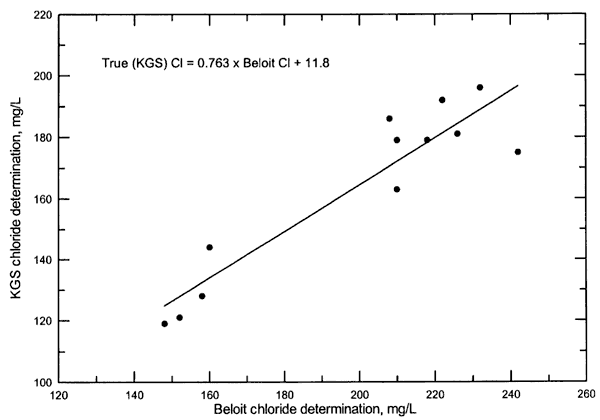
The chloride concentration determinations by the City of Beloit were consistently higher (11-38%) and averaged 22% greater than the KGS values. Figure 2 displays the relationship between the KGS and Beloit values. The equation for the linear regression on the graph can be used to estimate the true chloride concentration given the Beloit chloride measurement. Adjustment of the Beloit chloride measurements based on division by 1.22 also gives values close to those from the regression equation. The sulfate content measurements by Beloit varied substantially relative to the KGS determinations; most of the values were greater and some values were less than those of the KGS. The Beloit sulfate measurements averaged 10% higher than those of the KGS. Although a small part of the sulfate concentration differences between Beloit and the KGS could have been derived from flow differences at the times of sampling, most of the differences are due to analytical errors. The mean sulfate/chloride ratio for the Beloit samples for which the City determined both chloride and sulfate on the same sample (Table 3) is 1.63, which is 11% lower than the mean ratio for the KGS analyses. This difference is consistent with the 12% difference between the 22% and 10% larger values of the chloride and sulfate values of the City in comparison with the KGS.
Figure 2. Comparison of KGS and Beloit chloride determinations during 2002-2003. The line and equation are for the linear regression of the data.
Prev Page--Introduction || Next Page--Data Analysis
Kansas Geological Survey, Geohydrology
Comments to webadmin@kgs.ku.edu
Placed online Jan. 17, 2006
URL=http://www.kgs.ku.edu/Hydro/Publications/2003/OFR03_49/03_quality.html