![]()
Prev Page--Recharge || Next Page--Chemical Character
Ground Water, continued
Recovery of Ground Water
Principles of Recovery
When the water level in a well is at the static level there is an equilibrium between the pressure of water within the well and the pressure of water outside the well. When water is pumped from a well the pressure inside the well is reduced and water moves into the well. When water is being discharged from a well the water table in the vicinity of the well is lowered to form a depression resembling an inverted cone. This depression of the water table is called the cone of depression, and the distance that the water table is lowered is called the drawdown. In a well, the greater the pumping rate the greater will be the drawdown. When pumping stops, the cone of depression gradually fills with water from adjacent areas until equilibrium is reached again.
The capacity of a well is the rate at which it will yield water after the water stored in the well has been removed. The capacity depends upon the quantity of water available, the thickness and permeability of the aquifer, and upon the construction and condition of the well itself. The capacity of a well is usually expressed in gallons a minute.
When a well is pumped, the water level drops rapidly at first and then more slowly, but it may continue to decline for several hours or days. When pumping ceases the water level rises rapidly at first but recovery becomes progressively slower and may continue for some time after pumping has stopped.
Dug Wells
Dug wells are wells that have been excavated, usually by hand with pick and shovel, or sometimes with power machinery. Some of the early wells in Sherman County were dug, but most of these have been replaced by drilled wells. Well 8-39-19bab, one of the Goodland municipal wells, was originally dug to slightly below the water table and later drilled to a depth of about 300 feet, the drilled part being cased with 12-inch iron casing. Well 8-39-19cad2, owned by the Chicago, Rock Island and Pacific Railway Company, was originally dug to a depth of 165 feet. The well was later drilled to about 255 feet, cased with 12-inch steel casing for its entire depth, and the dug part filled in. Several shallow irrigation wells in stream valleys were dug to the water table, then drilled deeper.
Bored Wells
Bored wells are made by post-hole diggers or hand augers in unconsolidated sediments. Some of the shallow wells in valley areas were made in this way.
Drilled Wells
Most of the wells in Sherman County have been drilled by means of either a percussion or hydraulic-rotary drill. In the percussion method, a portable cable-tool drill mounted on a truck or trailer is used. This method of drilling uses a heavy bit which is lifted and dropped alternately to produce a cutting action at the bottom of the hole. The crushed material in the well is mixed with water added during the drilling and is removed by means of a bailer. In the hydraulic-rotary method a hollow drill stem equipped with a cutting bit is rotated in the hole; cuttings are removed by circulating muddy water under pressure down through the stem and up through the annular space between the drill pipe and the hole. The cuttings are brought to the surface as fragments suspended in the mud. The mud also serves to plaster the walls of the hole, thereby preventing caving until casing is installed. In the reverse-rotary method, which is sometimes employed in the drilling of large-diameter wells, direction of flow of water is reversed and the cuttings are carried up through the drill stem.
Most of the drilled wells in Sherman County obtain water from unconsolidated or only partly consolidated deposits of Pliocene age. Wells in these deposits are usually cased to the bottom with steel, iron, or galvanized iron casing to prevent caving of the walls. In some wells the water may enter only through the open end of the casing, but in most wells, the casing is perforated below the water table to increase the intake area. The size and shape of the perforations is an important factor in the construction of a well, and the capacity and even the life of the well may be determined by it. If the perforations are too large, fine material may filter through and fill the well; if the perforations are too small they may become clogged so that water is prevented from entering the well freely. A common practice is to select a slot size that will pass from 30 to 60 percent by size of the water-bearing material. The coarser particles that remain around the screen form a natural gravel packing that increases the effective diameter and therefore the capacity of the well.
Gravel-wall wells generally are effective for obtaining large supplies of water from relatively fine-grained unconsolidated deposits, and have been used for public supply and irrigation. In constructing a well of this type a hole of large diameter is first drilled and temporarily cased with unperforated casing. A well screen or perforated casing is centered in the hole opposite the water-bearing beds and enough unperforated casing is added to reach the surface. The space between the two casings is filled with sorted gravel, preferably of a grain size just a little larger than the openings in the screen or perforated casing, and also slightly larger than that of the water-bearing material. The outer casing is then withdrawn to uncover the screen and to allow the flow of water from the water-bearing material through the gravel packing. The envelope of select gravel that surrounds the well increases the effective diameter of the well and decreases the velocity of the water leaving the formation. This reduction in velocity reduces the movement of fine sand into the well. Due to the increased effective area offered by this type of construction, the entrance friction of the water is reduced and consequently the drawdown may be reduced. A reduction in drawdown at a given yield increases the specific capacity and reduces the cost of pumping.
McCall and Davison (1939, p. 29) have summarized the procedures, which when observed in drilling, will tend to minimize drawdown and thereby increase the efficiency of the well:
First, the well should be put down through all valuable water-bearing material. Secondly, the casing used should be properly perforated so as to admit water to the well as rapidly as the surrounding gravel will yield the water. Third, the well should be completely developed so that the water will flow freely into the well.
Increasing the diameter of the well will decrease the drawdown but little, all else remaining equal. . . . Increasing the depth of the well will have a greater effect on reducing the drawdown than will increasing the diameter, so long as additional water-bearing formations are encountered.
Methods of Lift and Types of Pumps
Most of the domestic and stock wells in Sherman County are equipped with lift or force pumps. The cylinders or working barrels in lift pumps and force pumps are similar and for best results are placed at a level below the water table. A lift pump generally discharges water only at the pump head, whereas a force pump can force water above this level--such as to an elevated tank. A few wells are equipped with jet pumps and one shallow stock well that was inventoried had a pitcher pump. Domestic and stock wells in Sherman County are generally operated by windmills, but some are operated by hand and several are powered by electric motors or gasoline engines.
Irrigation wells in Sherman County are equipped with either horizontal centrifugal, or vertical turbine pumps (Pl. 6B). The horizontal centrifugal pumps in Sherman County are usually set in pits dug nearly to the water table. They can be used only where the depth to water plus the drawdown does not exceed the working suction limit. Turbine pumps are used for most of the irrigation wells and city wells. Well 8-42-20cdb, one of the municipal wells in Kanorado, is equipped with a double-action plunger pump.
Plate 6B--Deep-well pumping plant owned by Albert Vohs, SW SE sec. 28, T. 8 S., R. 38 W.
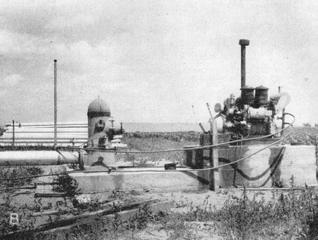
The pumps in the municipal and railroad wells are powered by electricity, and most of the pumps in the irrigation wells are powered by gasoline or diesel engines. One irrigation well is near the natural gas line from Colby to Goodland, and the pump is powered by an engine using natural gas.
Utilization of Ground Water
Information on 326 wells in Sherman County was obtained during the course of the investigation. All known irrigation, public-supply, and industrial wells in the county were visited and all available data concerning them were collected. Only a small percentage of the domestic and stock wells in the county were visited. Records of wells are listed in Table 10, and the principal uses of water are described below.
Domestic and Stock Supplies
All domestic supplies in rural areas and domestic supplies in the towns of Ruleton and Edson, which have no municipal water supplies, are obtained from wells. Most of the water used by livestock also comes from wells, although some is obtained from undrained depressions, stock ponds, or creeks. In Sherman County ground water is generally moderately hard, but is satisfactory for most uses.
Public Supplies
Public supplies of water are obtained from wells at Goodland and Kanorado in Sherman County.
Goodland--Goodland, the county seat of Sherman County, obtains its water supply from three wells. [Note: In 1950, a new well was drilled to replace well 8-39-19bab, which had caved in. No information on this new well was obtained.] All the wells are about 300 feet deep and the depth to static water level in each well is nearly 150 feet. Data on the wells are given in Table 10. The wells are equipped with electrically driven deep-well turbine pumps. Storage is provided by an elevated tank having a capacity of 250,000 gallons and a standpipe holding 213,000 gallons. Well 8-39-19bab, at the fire station, pumps into the standpipe. Well 8-39-20cbc, at the power plant, pumps into the elevated tank. Well 8-39-19aaa, in Gulik Park, pumps directly into the mains. The estimated yield of each well is 300 gallons a minute. The daily average consumption of water at Goodland is not known. The water, of good quality, is chlorinated as an extra precaution against possible contamination.
Kanorado--The City of Kanorado, on the western border of the county, obtains its water supply from two drilled wells approximately 180 feet deep. Well 8-42-20cdb, equipped with a double-action plunger pump, is reported to yield 100 gallons a minute. Well 8-42-29bac, which has a deep-well turbine pump, has an estimated yield of 250 gallons a minute. The wells pump directly into the mains, the excess water being stored in an elevated tank holding 55,000 gallons. The daily consumption of water is not known. The water is not treated.
Industrial Supplies
The largest industrial user of ground water in Sherman County is the Chicago, Rock Island and Pacific Railway Company at Goodland. The railroad has three wells, which supply water principally for filling locomotive boilers. Well 8-39-19cad2, pumped by an electrically driven submersible turbine, has been the principal source of water used by the railroad at Goodland. Well 8-39-19cad was drilled in 1949 and equipped with a deep-well turbine pump but had not been put into use at the time field work for this report was done. Well 8-39-19cad3, equipped with a piston pump, was used only for emergencies. Water is stored in two tanks having capacities of 75,000 gallons and 150,000 gallons. According to L. W. Everetts, Water Service Superintendent, about 150,000 gallons of water a day is used by the railroad.
Some ground water is used in Goodland for air conditioning but much of it is purchased from the city. However, well 8-39-19adb owned by Commonwealth Theatres is used for air conditioning the Sherman Theatre. This well is 209 feet deep and is cased with 12-inch steel casing. Water is pumped by a deep-well turbine powered by an electric motor. The Goodland Boothroy Memorial Hospital also has a well used for air conditioning.
Irrigation Supplies
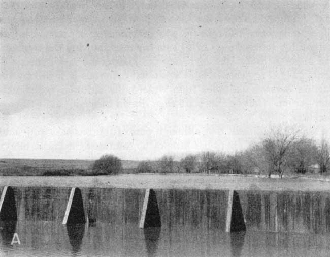
Irrigation is not practiced extensively in Sherman County. Although 19 of the wells visited are classed as irrigation wells, only 5 wells (8-39-15ccc, 8-38-28acc, 7-40-11dcc, 9-41-18cbb, and 10-40-23bdc) pumped appreciable amounts of water in 1949. Well 8-40-12dba was pumped occasionally to fill a small pond, but most of the other wells were not pumped at all. Some of them had not been in use for several years. Well 6-42-26acc was a new well drilled in the summer of 1949; it had not been put into use at the time of the investigation. The total acreage under irrigation is not known, but it does not exceed a few hundred acres. The amount of water used for irrigation is not known. A few domestic wells equipped with windmills sometimes pump water to irrigate small garden plots, but the amount of water used for this purpose is negligible. In addition to pumpage from wells a small amount of water is pumped for irrigation from the North Fork Smoky Hill River. The water was pumped from the upper end of a pond formed by the damming of the river (Pl. 7A).
Plate 7A--View of Smoky Lake, looking wet; sec. 14, T. 10 S., R. 40 W.
The yields of four irrigation wells were determined by pumping tests made by members of the Federal Geological Survey. Yields measured by the Collins flow gauge ranged from about 316 to slightly more than 1,170 gallons a minute. Drawdowns as measured by the wetted-tape method during the pumping ranged from about 10 feet to 30 feet. A chemical analysis of a sample of water taken from well 8-39-15ccc indicates that the water is excellent for irrigation.
Possibilities of further development of irrigation supplies--The feasibility of further development of irrigation supplies from wells is dependent principally on geologic, hydrologic, and economic factors. The amount of water available for irrigation depends on the thickness and extent of the water-bearing beds, the permeability of the material, and the amount of recharge to the ground-water reservoir. Figure 11 shows the saturated thickness of Pleistocene and Pliocene deposits. The figure was prepared by superimposing the water-table contour map (Pl. 1) on the map showing the configuration of the bedrock surface below the Pleistocene and Pliocene deposits (Fig. 7). Thickness of saturated materials is found by subtracting bedrock altitudes from water-table altitudes at points of intersection. Contour lines are then drawn through points of equal thickness.
Fig. 11--Map showing the saturated thickness of Tertiary and Quaternary deposits in Sherman County.
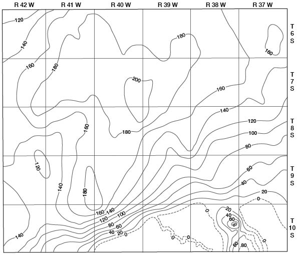
Figure 11 indicates that although part of southeastern and south-central Sherman County has little or no saturated thickness, most of the county has a considerable amount of water-bearing material, the maximum being slightly more than 200 feet. Test drilling has indicated that the water-bearing beds in places are rather fine-grained, have low permeabilities, and would consequently yield water to wells slowly, but large yields can be obtained from wells where materials having high permeabilities are penetrated.
The cost of drilling and pumping is determined in part by the depth to water level. In areas where the water table is deep, the wells must also be deep and the pumping lift is great. Plate 2, which shows the depth to water level, indicates the depth to the water level in Sherman County ranges from a few feet to more than 200 feet. In much of the upland area where the contour of the land is suitable for irrigation the depth to water level is much more than 100 feet. As permeabilities of water-bearing formations are generally low in Sherman County, drawdowns in wells of large capacity would be large. The large drawdowns together with the relatively great depths to water result in a fairly high cost of irrigation. However, it is beyond the scope of this report to say what the greatest depth of profitable pumping will be because, as previously stated, so many other factors must be considered.
In some of the stream valleys the depths to water are not great and where water-bearing materials are relatively permeable, wells having high yields may be drilled and pumped economically. The creek bottoms generally are not very wide and commonly very little land is suitable for irrigation. The most promising area for future irrigation seems to be along Beaver Creek where depths to water level are not great, permeabilities are fairly high, and there is considerable land suitable for irrigation.
Prev Page--Recharge || Next Page--Chemical Character
Kansas Geological Survey, Geology
Placed on web Aug. 1, 2008; originally published Nov. 1953.
Comments to webadmin@kgs.ku.edu
The URL for this page is http://www.kgs.ku.edu/General/Geology/Sherman/05_gw3.html