![]()
Prev Page--Geography || Next Page--Ground Water
Geology
Summary of Stratigraphy
[Note: The geologic classification and nomenclature of this report follow the usage of the State Geological Survey of Kansas and differ somewhat from those used by the U. S. Geological Survey.]
The rocks cropping out in Sherman County are of sedimentary origin and range in age from late Cretaceous (Gulfian) to Recent (Pl. 1). The Pierre shale (Cretaceous), oldest outcropping rock in Sherman County, crops out in a few places along the southern border and underlies the entire county.
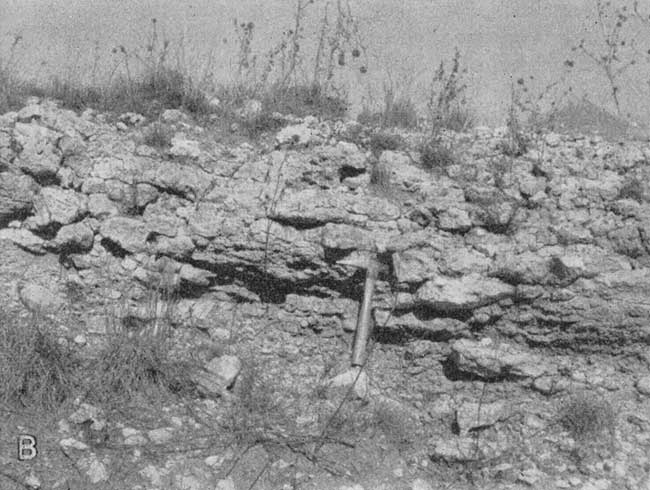
Except where it has been removed by erosion and the Pierre is exposed, the Ogallala formation (Pliocene) overlies the Pierre shale throughout the county. It is exposed in bluffs along some of the stream valleys (Pl. 5A), but is commonly covered by a thick deposit of wind-blown silt (loess), which is the Sanborn formation (Pleistocene). Colluvial materials derived partly from the underlying Pliocene bedrock, but mainly from the loess mantle, cover some of the slopes. For convenience, these slope deposits are included with the Sanborn formation on the geologic map. The youngest deposits, Recent in age, consist of sand, gravel, and silt under the channels and flood plains of several of the streams that cross the county. The character and water-bearing properties of the geologic formations are described briefly in Table 2; more detail is given in the section on geologic formations and their hydrologic properties. The stratigraphic relations of the formations are shown in the geologic cross sections through Sherman County (Figs. 5 and 6).
Plate 5A--Bluffs formed by beds of the Ogallala formation in the SW sec. 13, T. 10 S., R. 40 W., south of the North Fork Smoky Hill River. View looking southeast.
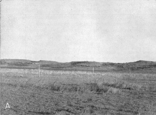
Fig. 5--Geologic cross sections through Sherman County along lines A-A' and B-B'. A larger version of this figure is available.
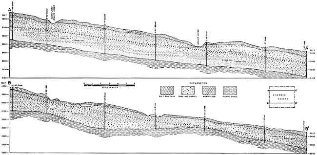
Fig. 6--Geologic cross sections through Sherman County along lines C-C', D-D', and E-E'. A larger version of this figure is available.
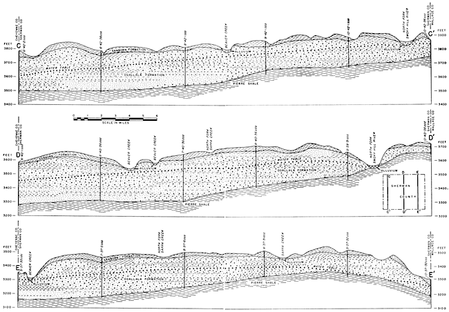
Table 2--Generalized section of the geologic formations in Sherman County. The classification is that of the State Geological Survey of Kansas.
| System | Series | Formation | Thickness (in feet) |
Character | Water supply |
|---|---|---|---|---|---|
| Quaternary | Pleistocene | Alluvium | 0-35 | Sand, gravel, and silt along most of the stream valleys. | Commonly above water table except along parts of Beaver Creek and North Fork Smoky Hill River where it yields moderate quantities of water to wells. |
| Sanborn formation |
0-50 | Silt, tan to reddish-brown, in places contains much very fine sand and locally contains sand and gravel at the base. | Lies above the water table and yields water to wells in this area. | ||
| Tertiary | Pliocene | Ogallala formation |
0-300 | Sand, gravel, and silt, predominantly calcareous; may be consolidated or unconsolidated; contains limestone beds and a volcanic ash bed. | Yields moderate to large supplies of water to wells in most of the county. |
| Cretaceous | Gulfian | Pierre shale |
600-900± | Shale, dark-gray to black. | Yields a small quantity of water to a few wells in southern Sherman County. |
Geologic History
Paleozoic Era
In the earliest part of the Paleozoic Era, the part of the west-central United States in which Sherman County is situated was above sea level. Submergence of the land began in middle Cambrian time, and an interior sea covered the area until some time during the Ordovician Period when the area was uplifted. Rocks deposited during Cambrian and Ordovician time are represented in the subsurface of western Kansas by the Arbuckle group (Cambrian and Ordovician in age) and the Viola limestone (Ordovician). According to Ver Wiebe (1946, p. 107) an oil test drilled in the SW sec. 20, T. 10 S., R. 38 W. encountered the Arbuckle group at 5,382 feet; at 5,640 feet, when drilling ceased, the Arbuckle had not been penetrated completely.
Silurian and Devonian rocks probably do not underlie Sherman County. A low land mass or a shallow sea may have been present, but so far as is known there was no deposition or erosion during this time. During early Mississippian time the land subsided, and deep-water marine deposition followed. Deposits of marine dolomitic limestone and shale were laid down in this area during early Mississippian time. In late Mississippian time the sea withdrew, and early Mississippian strata were eroded. In Pennsylvanian time, subsidence and uplift alternated, resulting in the deposition of both marine and continental rocks, consisting of sandstone, shale, limestone, and coal. During the Permian Period, emergence predominated over submergence and sediments were deposited in shallow basins or on low plains. The deposits consist of red shale and sandstone which contain beds of salt, anhydrite, and gypsum, indicating that arid conditions prevailed during the Permian.
Mesozoic Era
The Paleozoic Era in western Kansas was probably terminated by an uplift that brought the region above sea level where it remained during Triassic time and early Jurassic time. In late Jurassic time the land subsided and sediments which were deposited have been tentatively correlated with the Morrison formation. These deposits consist of about 60 feet of light-green, gray, and red shale which contains much rose to milky-white jasperlike chert in the lower part. Rocks of Jurassic age are not present in much of western Kansas, but have been identified in drill cuttings in Sheridan County (Ver Wiebe, 1940, p. 104) and in Logan, Gove, and Trego counties (Landes and Keroher, 1939, p. 25). Deposition was ended by an uplift near the end of the Jurassic or in early Cretaceous time. This uplift was not of long duration and during late Comanchean time, the sandstones and shales of the Cheyenne sandstone were deposited either by streams or in a shallow sea.
The land was next submerged under a moderately deep sea and the Kiowa shale was deposited. Following the deposition of the Kiowa, conditions similar to those when the Cheyenne was deposited reoccurred, and the sandstones, shales, and clays of the Dakota formation were deposited. The Dakota is a fresh-water deposit that was laid down on a beach or near the shore during an uplift of the land. In earlier reports on Sheridan County (Ver Wiebe, 1940, p. 104) and on Logan, Gove, and Trego counties (Landes and Keroher, 1939, p. 24) no attempts were made to distinguish the Cheyenne and Kiowa from the Dakota. A study of samples of cuttings from an oil-test well drilled in the SW cor. sec. 20, T. 10 S., R. 38 W., on the Cogswell ranch indicates that 450 feet of sediments, consisting mainly of sandstone, shale, and clay, are included in the interval between the Graneros shale, above, and the Morrison formation, below. Of this, 380 feet is considered to be Dakota formation and the remaining 70 feet is correlated with the Cheyenne and Kiowa formations.
During most of the remainder of the Cretaceous Period, marine conditions prevailed in this area and hundreds of feet of shale, limestone, and chalk were deposited. These formations in order of deposition are: the Graneros shale, the Greenhorn limestone, the Carlile shale, the Niobrara formation, and the Pierre shale. The presence of numerous thin beds of bentonitic clay in these formations indicates that at different times volcanic ash was blown into the seas in which sediments were being deposited. The ash settled in layers and was subsequently altered to bentonite.
Cenozoic Era
Tertiary Period
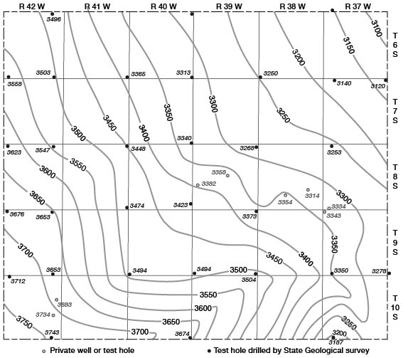
In early Tertiary time there was extensive uplift in the Rocky Mountain province. While streams from the mountains were laying down widespread sheets of sand, gravel, and silt in the region to the north, the land surface of western Kansas was being eroded and any sediments that might have been deposited in earliest Tertiary time together with varying thicknesses of Upper Cretaceous sediments were removed. The configuration of the land surface at the end of this early Tertiary erosion is shown by the contact between the Ogallala formation and Pierre shale in Figures 5 and 6 and by contours in Figure 7. In Pliocene time conditions were reversed, probably due to differential uplift of the land, and streams from the Rocky Mountains made extensive deposits of sand, gravel, silt, and clay that comprise the Ogallala formation over the High Plains surface. As deposition proceeded, bedrock divides were buried deeper and deeper, and by the end of deposition the erosional plain in the Rocky Mountain region merged with the aggradational plain in the Great Plains.
Fig. 7--Map of Sherman County showing the configuration of the bedrock surface beneath Tertiary deposits by means of contours, and the locations of test holes.
At many localities there is a distinctive hard bed of limestone at the top of the Pliocene Ogallala formation. This limestone was described by Elias (1931, pp. 136-141) and named the "Chlorellopsis limestone" or "Algal limestone" from the presence of the abundant remains of the fossil alga, Chlorellopsis bradleyi (Pl. 5B). Elias (1931, p. 141) believed that the limestone was deposited on the bottom of a very large shallow lake near the close of Ogallala time. He advocated the lacustrine origin because living algae related to Chlorellopsis are not known to precipitate calcium carbonate in running waters. It is probable that no single large lake existed, but rather many small lakes. Near the end of Ogallala deposition stream gradients were low and stream channels became choked with sediments. This may have caused lateral shifting of channels and may have resulted in the formation of many lakes, for the most part disconnected and occupied by still water.
Plate 5B--"Algal limestone" of Ogallala formation in cut made by Chicago, Rock Island, and Pacific Railway Company, SE sec. 23, T. 8 S., R. 42 W.
Pleistocene Epoch--During early Quaternary time the land to the west was uplifted and streams in western Kansas began to cut through the Pliocene deposits. Later, sedimentation was resumed and alluvial deposits of sand and gravel were deposited along some of the major stream valleys. A history of successive periods of stream erosion and deposition is shown by the terraces of major valleys cast of Sherman County (Frye, Leonard, and Hibbard, 1943; Frye and Leonard, 1949), but if there are alluvial deposits of more than one age in Sherman County, the different ages have not been determined. Tt is possible that some of the gravel beds to the south in Wallace County that Elias referred to as the basal part of the Sanborn formation (1931, p. 163) were laid down during this time. Later in Pleistocene time winds became strong. A layer of windblown silt (loess) was deposited over the area to depths of as much as 50 feet. The loess and underlying sand and gravel were named Sanborn formation by Elias (1931, p. 163).
During Recent time the county has undergone erosion that has formed much of its present topography. Streams have cut deeply into Pliocene deposits and along the eastern reach of North Fork Smoky Hill River the Ogallala formation has been removed and the Pierre shale is exposed. The loess mantle has been modified by the action of sheet and rill wash, and some slopes are covered by thick colluvial deposits that have moved down from the uplands by slope processes. In many places these slope deposits are contiguous with alluvium, which occupies the floors of most of the stream valleys, and the boundary between the two is usually indistinct.
During Recent time, many shallow depressions have developed on the upland areas in Sherman County and in many areas in the High Plains. The depressions range from a few tens of feet to about half a mile in diameter. Most of them bold water after periods of heavy rainfall until the water has evaporated or percolated into the soil.
The origin of the depressions has been a perplexing problem to geologists for many years; several theories of origin have been offered. Darton (1916, pp. 36-37) referred to some of these High Plains depressions as "buffalo wallows" and explained their origin by the action of buffaloes and wind. He believed that the depressions were started by buffaloes, either at wet, salty, or alkali spots, and that they were excavated by tramping hoofs and by mud sticking to the shaggy coats of the animals during wet periods. After breaking of the sod cover, wind scour became the dominant mode of erosion during dry periods. This hypothesis might account for some of the small depressions having depths of 10 feet or less (Pl. 4B), but seems inadequate for the larger, more extensive depressions (Pl. 4A).
For large depressions or basins in areas of Permian bedrock, Johnson (1901, pp. 702-712) advocated an origin by solution of soluble beds of the Permian followed by collapse of the overlying beds and development of surface depressions. This theory explains satisfactorily the origin of large sinks such as Salt Well in Meade County and Big Basin and St. Jacob's Well in western Clark County, but does not adequately explain the origin of depressions--especially small shallow depressions--in areas of thick Cretaceous bedrock. Johnson believed that a grain-by-grain process of compaction and readjustment within the Tertiary alone was responsible for the innumerable small upland depressions in areas of thick Cretaceous bedrock. Concerning the mechanics of the compaction process, he stated (1901, pp. 703, 704):
Appearances indicate basining of the alluvial surface as a consequence, first, of rain water accumulation in initial faint unevenesses of the plain; second, of percolation of this ponded surface water downward to the ground water in largely increased amount from these small areas of concentration, rather than from over the whole surface uniformly, with the result that the alluvial mass is appreciably settled beneath the basins only. The inference is at once suggested that this settlement takes place as the combined effect of mechanical compacting of the ground particles and the chemical solution of the more soluble particles. Finally, these effects should be cumulative, resulting in the growth noted, since, with enlargement of the basins, concentration of rain water within them will be on an increased scale.
Hay in 1895 (pp. 555-556) described the development of sink holes in Sherman County, which were discovered after a very hard rain in May 1894. Hay remarked:
The storm of last May probably only completed a process of widening natural channels that percolating waters bad been busy performing for ages.
Hay's idea on the formation of sink holes is similar to Johnson's compaction hypothesis. This hypothesis seems to fit best several large depressions in Sherman County, especially those in the NW sec. 26, T. 8 S., R. 42 W., and in the Cen. sec. 2, T. 9 S., R. 40 W. The former is about 35 feet deep and the latter is approximately 60 feet deep. The depressions are too large and deep to be explained by the "buffalo wallow" theory and the thickness of the Ogallala formation and Pierre shale are prohibitive to Johnson's theory of the solution of soluble beds. Many of the smaller depressions could have been caused by buffaloes but Johnson's compaction theory seems to be the most adequate explanation.
Prev Page--Geography || Next Page--Ground Water
Kansas Geological Survey, Geology
Placed on web Aug. 1, 2008; originally published Nov. 1953.
Comments to webadmin@kgs.ku.edu
The URL for this page is http://www.kgs.ku.edu/General/Geology/Sherman/04_rock.html