![]()
Prev Page--Chemical Character || Next Page--Well Records
Geologic Formations and their Water-bearing Properties
Cretaceous System
Gulfian Series
Pierre Shale
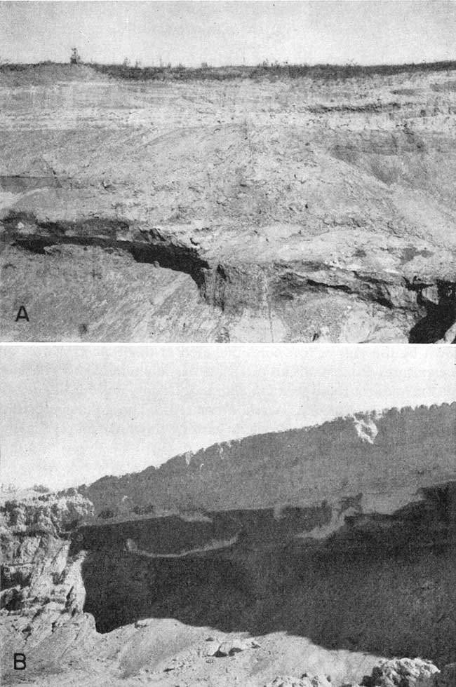
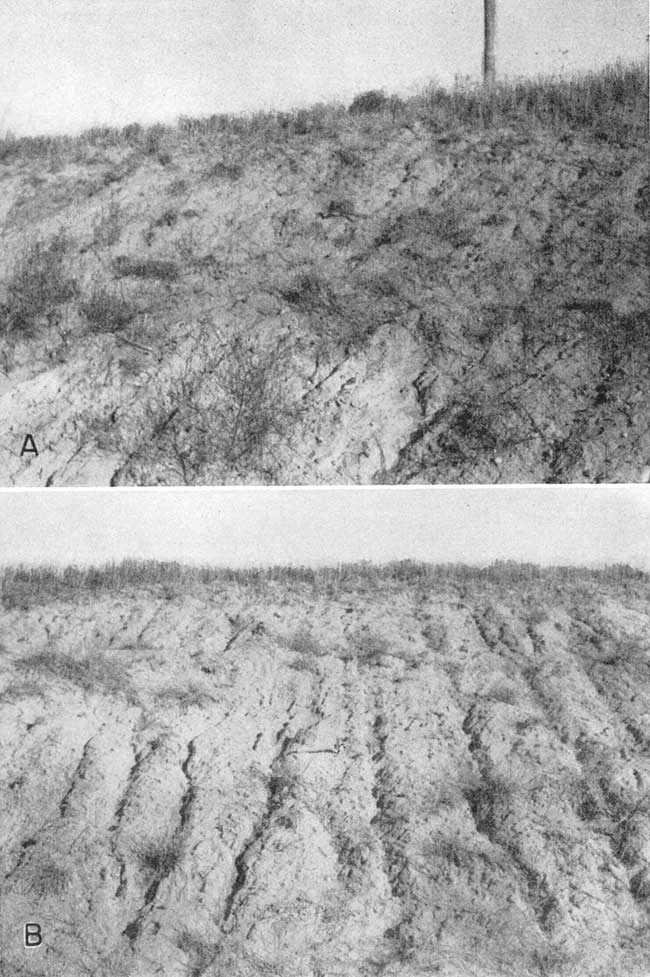
The oldest formation that crops out in Sherman County is the Pierre shale (late Cretaceous in age) (Pl. 7B). The Pierre shale was named by Meek and Hayden in 1862 from exposures at old Fort Pierre in South Dakota. The Pierre shale in northwestern Kansas has been studied and described in great detail by Elias (1931). He divided the Pierre shale into five named members and one unnamed unit. These are, in ascending order: Sharon Springs shale, Weskan shale, Lake Creek shale, Salt Grass shale, an unnamed shale interval, and the Beecher Island shale. Probably all but the Beecher Island shale member are present under most of Sherman County. The Lake Creek shale is thought to be the only member of the Pierre shale to crop out in Sherman County. The Lake Creek shale consists of dark-gray and black shale. It contains many limonite concretionary zones and small concretions of calcium carbonate. The Lake Creek shale member differs from the Weskan shale member below and the Salt Grass shale member above by the absence or scarcity of the large limestone concretions that are so common in the members above and below (Elias, 1931, p. 93). The maximum thickness of the Lake Creek shale member is about 200 feet in Wallace County but its thickness is not known in Sherman County. The total thickness of the Pierre shale in Sherman County ranges from about 600 feet in the southern part of the county to perhaps as much as 900 feet in the north.
Plate 7B--Exposure of Pierre shale in sec. 34, T. 10 S., R. 39 W.
The Pierre shale is not known to yield water to wells in Sherman County, but well 11-40-1bcc on the northern border of Wallace County obtains its water from the Pierre. Shale is a poor aquifer but locally may contain water in joints and along bedding, planes. The sample from this well indicates that water from the Pierre shale is of poorer quality than water from the Ogallala formation. It contains more dissolved solids, is harder, and has a slightly higher fluoride content than Ogallala water in Sherman County. P. M. Piper reported that when his well (11-40-1bcc) is allowed to stand for a day or two without pumping, the water acquires a peculiar odor. This may be due to the high sulfate content of the water.
Tertiary System
Pliocene Series
Ogallala Formation
The Ogallala formation was named by Darton in 1899 (pp. 732734) from a locality in southwestern Nebraska. In 1920 Darton (p. 6) referred to the type locality as near Ogallala station in western Nebraska. Elias (1931) made a detailed study of the Ogallala formation in Wallace County, and in 1937 he briefly described Ogallala deposits in Rawlins and Decatur Counties. In 1945 the Ogallala formation in Thomas County was described by Frye, and in 1949 Frye and Leonard described the character and occurrence of the Ogallala in Norton and Phillips Counties.
Character--The Ogallala formation in Sherman County consists of clastic sediments of diverse character. It contains chiefly sand and gravel, silt, clay, some limestone, and beds of volcanic ash and bentonitic clay. To the south in Wallace County it contains diatomaceous marl and in other areas it contains hard silicified beds resembling chert or quartzite. The character of the Ogallala is shown by the logs of test holes included in this report. There are no exposures that permit an extensive examination of any considerable thickness of these strata in Sherman County and for this reason no stratigraphic sections were measured. The following stratigraphic section was measured in eastern Rawlins County. (Frye 1945, pp. 63-64).
| Bed no. |
Measured section of the Ogallala formation, SE sec. 30, T. 5 S., R. 32 W., Rawlins County. (Measured by John C. Frye and August Lauterbach.) | Thickness, feet |
|---|---|---|
| 13 | Mostly covered, capped by nodular mortar bed, irregular, hard, gray | 6.0 |
| 12 | Mortar bed, coarse gravel to sand cemented by calcium carbonate; weathers irregularly cavernous | 5.5 |
| 11 | Silt, sand, and gravel; massive; poorly sorted; red-tan | 7.0 |
| 10 | Mortar bed, sand and some fine gravel; loosely cemented by calcium carbonate; friable; gray | 1.5 |
| 9 | Silt, sand, and gravel; massive; poorly sorted; red-tan | 17.8 |
| 8 | Mortar bed, hard, massive, gray | 4.0 |
| 7 | Sand, fine, and some silt; tan to red-buff; partly covered | 7.5 |
| 6 | Mortar bed, hard, gray | 3.5 |
| 5 | Sand, fine to medium, tan to buff, partly covered | 6.0 |
| 4 | Mortar bed, sand and coarse gravel; hard; gray | 2.2 |
| 3 | Sand and gravel; tan | 9.5 |
| 2 | Caliche and mortar bed; massive; having thin lenses of clay and silt interbedded; light-gray to light gray-tan | 8.0 |
| 1 | Silt and fine sand; massive; gray; covered in lower part | 13.7 |
| Total thickness of beds measured | 92.2 | |
The materials composing the formation are usually poorly sorted and may grade from one rock type to another within short distances both laterally and vertically. Individual beds are characteristically lenticular, and with the exception of a limestone member at the top, they cannot be traced very far.
Sand is the most common constituent of the Ogallala formation. It is composed predominantly of quartz but contains subordinate amounts of feldspar and other minerals. Test drilling has indicated that in some places beds of uniform well-sorted sand are found, but generally the sand is poorly sorted, being mixed with silt, clay, or gravel (Pl. 8).
Plate 8--Views of Ogallala deposits in gravel pit in the NE SE sec. 30, T. 8 S., R. 40 W. A, Cross-bedded sands resting on mortar bed. B, Bed of caliche at top resting on brown silt and sand, which in turn rests on partly cemented sand and gravel.
Beds of uniform gravel are not common, especially at depth. Generally gravel deposits contain large amounts of sand and silt, thus causing the formation to have a fairly low permeability.
Beds of sandy silt are very common in the Ogallala. The silt is gray, brown, red, tan, or buff; where it contains much calcium carbonate, it may be white. Silt layers generally contain nodules or stringers of caliche (calcium carbonate).
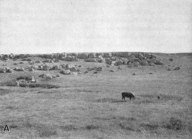
Many of the beds in the Ogallala formation are cemented, usually with calcium carbonate. Sand and gravel deposits cemented with calcium carbonate may form rough benches or scarps and are called "mortar beds" because of their resemblance to mortar (Pl. 9A).
Plate 9A--Mortar beds of the Ogallala formation. View looking eastward in NW sec. 21, T. 10 S., R. 39 W.
The most distinctive bed in the Ogallala is the "Algal limestone" (Pl. 5B) which is at the top of the formation. This limestone has a peculiar concentrically banded structure and was thought by Elias (1931, pp. 136-141) to have been at least partly precipitated by the alga Chlorellopsis. It is usually reddish and weathers to a knobby, irregular surface. Outcrops of "Algal limestone" are fairly common in Sherman County and have been found in several different localities (NW sec. 3, T. 8 S., R. 41 W.; SW NE sec. 27, T. 6 S., R. 41 W.; NW sec. 19, T. 7 S., R. 36 W. on the border of Thomas County; and NW sec. 1, T. 10 S., R. 41 W.).
Another distinctive bed found in one locality is a bed of white limestone that contains casts and molds of fossil snails. A similar formation crops out in Norton County (Frye and Leonard, 1949, p. 39) and in Wallace County where in places it overlies beds of diatomaceous marl (Elias, 1931, p. 162).
In a few localities in southern Sherman County the Ogallala contains layers of brown, tan, or greenish bentonitic clay. It is probable that this clay represents the "Woodhouse clay" described by Elias in Wallace County (1931, pp. 155-158).
Distribution and thickness--The Ogallala formation underlies all of Sherman County except for small areas in the southern part of the county where Pierre shale crops out or where alluvium of the North Fork Smoky Hill River lies directly on Pierre shale. The Ogallala is overlain in most of the county by the Sanborn formation, slope deposits, or alluvium, but the Ogallala crops out along most of the streams in places where it has been exposed by stream erosion, wind, or by soil creep. The thickness of the Ogallala ranges from a few feet to about 300 feet. The thickness of Ogallala sediments encountered in test hole drilling ranged from 296 feet in test hole 7-40-36ddd to 40 feet in test hole 10-40-36ddd. The thickness of the formation is shown in the cross sections (Figs. 5 and 6) and in the logs of test holes given in this report.
Origin--The sediments of the Ogallala formation were deposited largely by streams that flowed from the Rocky Mountains. During the early stages of deposition the main valleys were probably occupied by through-flowing streams from the Rockies. As time went by, stream channels became filled with deposits and stream gradients decreased. This led to overflow of streams and the building of broad flood plains. Channels themselves became choked and shifted laterally and probably anastomosing stream patterns developed. As deposition progressed, relief was lowered, valleys became filled, divides were covered, and the depositional zones of individual streams overlapped and coalesced.
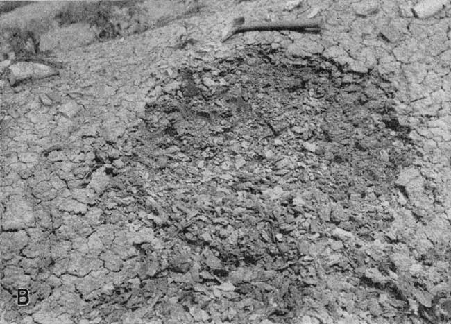
However, not all the Ogallala deposits were laid down by running water. It is thought that at various times during Ogallala deposition there were small shallow lakes, probably formed by damming of stream channels. This is substantiated by the beds of volcanic ash (Pl. 9B), which must have been deposited in still water, in the Ogallala of this county and other counties (Frye and Leonard, 1949, p. 39; Elias, 1937, p. 24). As previously discussed in the section on geologic history, it is thought that the "Algal limestone" was also formed in quiet water. Whereas the coarse materials in the Ogallala were undoubtedly deposited by streams, some of the deposits of structureless silt and fine sand may have been deposited by wind action.
Plate 9B--Bed of volcanic ash in Ogallala formation in the SW NE sec. 16, T. 8 S., R. 40 W. White spot at bottom right is a fresh exposure of ash.
Most of the materials of the Ogallala were derived from the Rocky Mountains. The silts and clays were derived from soils and weathered rocks in the mountain area. Sand and gravel was derived from the weathering of igneous rocks and clastic sedimentary rocks. Much of the calcareous matter that is so abundant in the Ogallala was derived from the weathering of Paleozoic limestones and calcic minerals in the igneous rocks. Some of the limy material may have been deposited by percolating subsurface water or ground water after the deposition of the rocks.
Age and correlation--In 1899 Darton (pp. 732, 734) applied the name Ogallala formation to deposits formerly called "Tertiary grit" and considered to be of Miocene age by Hay (1895, p. 570). Darton considered these deposits to be of Pliocene age. The formation now is generally considered to be of Pliocene age. The State Geological Survey of Kansas classes the Ogallala as a formation with three units, the Valentine, Ash Hollow, and Kimball, as members. The thickness of these members has not been determined in Sherman County, but all three members are undoubtedly present.
Fossil seeds and other plant remains from Tertiary rocks in the Great Plains have been described by Elias (1932, 1942) and Chaney and Elias (1936). The recognition of the Valentine, Ash Hollow, and Kimball members is based primarily on plant fossils because the Ogallala has few distinctive lithologic types. Elias (1942) considers Stipidium commune to be the most common grass seed in the Valentine member. Lower Ash Hollow contains abundant remains of Krynitzkia coroniformis, and the remainder of the Ash Hollow is characterized by the occurrence of Biorbia fossilia. The most diagnostic form found in the Kimball member is Prolithospernum johnstoni. However, because of the occurrence of the "Algal limestone" at the top of the Kimball, this member is often identifiable without recourse to fossil evidence.
Beds of volcanic ash are sometimes useful stratigraphically. However, the only ash deposit found in Sherman County, in sec. 16, T. 8 S., R. 40 W., is thought to be a new ash not previously identified in Kansas. It probably is in the upper part of the Ash Hollow or the lowest part of the Kimball.
A large number of Pliocene vertebrate fossils have been found in Ogallala deposits in Sherman County. The main source of these fossils is the "Edson Quarry" or "Edson beds" in secs. 25 and 26, T. 10 S., R. 38 W. This quarry was originally opened by Martin and described by Adams and Martin (1929). Several subsequent papers describing new species found in the "Edson Quarry" have been published (Hibbard, 1934; Taylor, 1941; Lane, 1945). The "Edson beds" are thought to occur low in the Ogallala, probably in the Valentine member.
Water supply--The Ogallala formation is the principal water-bearing formation in Sherman County. Most of the domestic and stock wells, all industrial and municipal wells, and the irrigation wells that were used in 1949 derive their water from the Ogallala formation. The Ogallala also yields water to a few springs in the county. The yields of wells deriving water from the Ogallala formation range from a few gallons a minute for domestic and stock wells to about 1,200 gallons a minute for one irrigation well. The irrigation wells that obtain water from this formation yield from 20 to 73 gallons a minute per foot of drawdown. Figures 5, 6, and 11 indicate that water-bearing materials, principally the Ogallala, reach a thickness of more than 200 feet in Sherman County and that most of the area is underlain by a considerable thickness of water-bearing material. However, although there is much ground water in storage in the Ogallala formation, logs of test holes indicate that in places the water-bearing beds may be fine-grained and would not yield water to wells without excessive drawdowns.
Water samples were collected from 22 wells that obtain water from the Ogallala formation. Chemical analyses indicate that the water is moderately hard but is of good quality both for domestic use and for irrigation. The quantity of fluoride in nine of the samples was slightly more than the amount considered to be the optimum fluoride content of water consumed by children, but probably, only very mild cases of mottled enamel would result from continuous drinking of this water.
Quaternary System
Pleistocene Series
Sanborn Formation
Character--In 1931 Elias (pp. 163-181) described unconsolidated Pleistocene deposits consisting mostly of silt in northwestern Cheyenne County, Kansas, and named these deposits Sanborn formation from the town of Sanborn, Nebraska, just north of the type area.
According to Elias (1931, pp. 179-180) there are three types of loess in Wallace County. These are: loess of the divides, loess of the valley slopes, and valley-bottom loess. He believed that only the loess of the divides could be considered of Pleistocene age, the loess of the valley slopes and valley bottoms having been redeposited from the divide areas. Probably only the loess of the divides should be termed loess and the loess of the valley slopes should be called colluvium or slope deposits. Elias acknowledged that the valley-bottom loess graded downward into alluvial sand and gravel and should be regarded as part of the alluvial deposits.
Slope deposits similar to those described in Wallace County are extensive in Sherman County where they cover the slopes of most of the valleys. The slope deposits in Sherman County consist mainly of loess of the Sanborn formation that has been redeposited by the action of wind, surface water, or slope processes, but deposits may also include fragments of the underlying Ogallala formation. Where the source material consists entirely of the Sanborn formation, slope deposits are indistinguishable from the Sanborn. Mechanical analyses of samples of Sanborn deposits and slope deposits in Thomas County indicate that where the slope deposits are derived from the upper massive silt of the Sanborn formation, they cannot be distinguished from it on the basis of grain size and sorting (Frye, 1945, p. 77). On the geologic map (Pl. 1) slope deposits are included with the Sanborn formation because of the similarity of the two formations and because of difficulties involved in trying to differentiate between the two.
In Sherman County two members of the Sanborn formation, the Peoria silt member and the Loveland silt member, have been recognized. The Loveland silt member, the lower member, consists of dark-brown silt; at its top is a buried soil (Sangamon) which developed during a period of subaerial erosion that occurred between the deposition of the two silt members. The soil is colored reddish brown by organic material and oxidation. The upper part of the soil has been leached of calcium carbonate which has been redeposited below as caliche. This soil is not well developed in Sherman County, but it has been observed in outcrops and in test holes (Pl. 10).
Plate 10--Exposures of loess in the Sanborn formation in Sherman County. A, Loess of the Peoria silt member overlying loess of the Loveland silt member. Ogallala formation beneath Loveland. View in road cut along U.S> Highway 24 in the SW sec. 21, T. 8 S., R. 40 W. B, Loess of the Peoria silt member overlying loess of the Loveland silt member. Indistinct contact is marked by position of hammer in picture. SW sec. 21, T. 8 S., R. 40 W.
The Peoria silt member consists of tan to light-brown silt and in a few places contains large amounts of very fine sand. The Brady soil, which is at the top of the Peoria silt and the Bignell silt member have not been found in Sherman County.
According to Elias (1931, p. 163) the basal part of the Sanborn formation in Wallace County contains coarse gravel, and boulders up to 2.5 feet in diameter were observed. Rocks found in the gravel deposits of Wallace County include arkose, granite, quartz, quartzite, basalt, porphry, flint, and jasper. Pieces of wood petrified into flint were common. The gravel was undoubtedly transported from the Rocky Mountain area. Although the Ogallala contains gravel of these same rocks, Elias considered that the "Sanborn" gravel was Pleistocene in age because of the occurrence of scratched cobbles and large boulders of arkose, both of which he had never observed in the Ogallala. The presence of heavy boulders and scratched cobbles suggested transportation by ice, probably by river or flood ice. Further evidence that this gravel is Pleistocene rather than Pliocene (Ogallala) is that in one location a few arkose boulders were observed to be clearly above the "Algal limestone," the topmost bed of the Ogallala (Elias, 1931, p. 178).
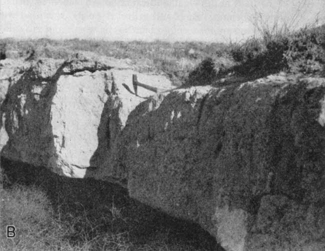
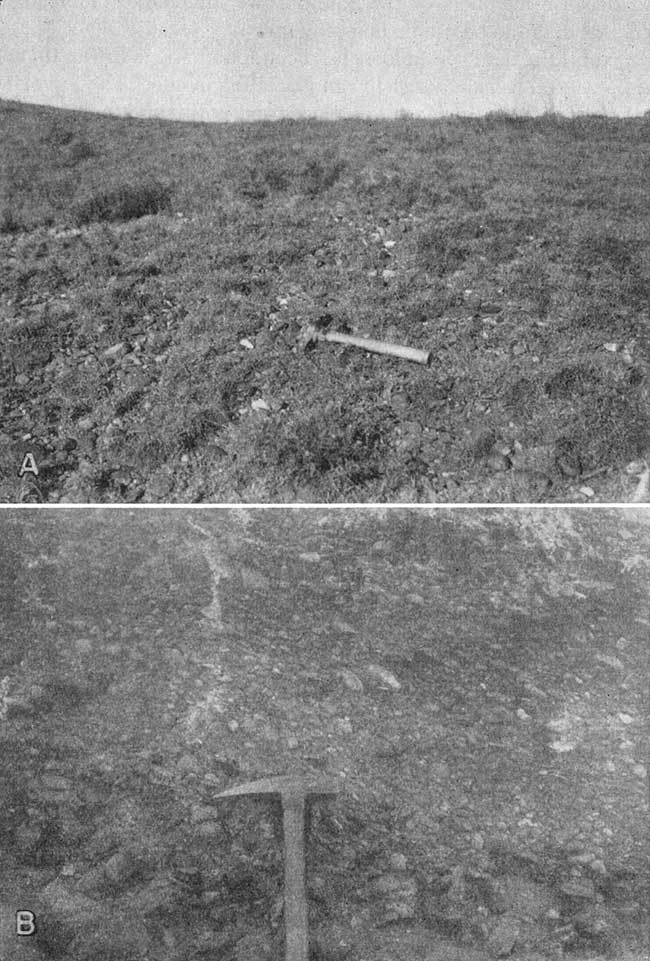
In some places in Sherman County deposits of gravel are found beneath loess and above mortar beds of the Ogallala. Boulders as large as 1 foot in diameter were noted in Sherman County. However, no evidence that these gravel deposits were of other than Pliocene age was found. No gravel deposits were found above the "Algal limestone" and scratched pebbles were not observed. Although it is possible that some of these gravel beds were deposited during Pleistocene time, until further investigation produces more definite evidence, these gravel deposits in Sherman County are being classed as gravels of the Ogallala which have been loosened from underlying cemented beds by leaching of calcium carbonate and by mechanical erosion. Plate 11A is a photograph of a gravel deposit that is considered to have been weathered directly from a bed of coarse, partly cemented gravel of the Ogallala such as that shown in Plate 11B.
Plate 11--A, Loose gravel of the Ogallala overlying consolidated Ogallala deposits, NW sec. 1, T. 10 S., R. 40 W. B, Coarse, partly cemented gravel in the Ogallala formation, SW NE sec. 6, T. 10 S., R. 39 W.
Distribution and thickness--Most of the surface of Sherman County is underlain by the Sanborn formation and associated slope deposits. All the test holes drilled in the county encountered loess or slope deposits which ranged in thickness from 1 to about 46 feet. The greatest thickness of the Loveland silt member was 8 feet; the Peoria silt member was more than 40 feet thick in Sherman County.
Age and correlation--The name Sanborn formation was first used by Elias (1931, p. 163) to replace such terms as "Tertiary marl" and "Plains marl" which were used by Hay (1895) and other early workers in the central Great Plains region for deposits later recognized as consisting mainly of loess. Elias considered these deposits to be Pleistocene in age. In 1937 in Decatur County, Kansas, Elias (1937, p. 7) noted the occurrence of a dark-brownish ("red") loess that underlay the light yellowish-buff loess of the Sanborn. This "red" loess he classified as equivalent to the Loveland formation of Nebraska.
The Loveland, Peoria, and Bignell silt members of the Sanborn formation in Kansas have been correlated with the Loveland, Peorian, and Bignell loesses of the Nebraska classification (Frye and Fent, 1947). To retain Sanborn as stratigraphic unit of formational rank in Kansas is desirable because it is a convenient mapping unit and because members of the Sanborn are difficult to delineate in sufficient detail to be usable mapping units.
In Nebraska the Peorian loess has been found above Iowan till and has been established as post-Iowan glaciation in age. The Loveland loess underlies the Iowan till in places and is Illinoian in age. The Bignell loess is considered to be late Wisconsinan.
Water supply--The Sanborn formation in Sherman County lies above the water table and therefore does not yield water to wells. The primary importance of the Sanborn with respect to water supply is its retarding effect on ground-water recharge due to the fine texture and low permeability of the silts.
Alluvium
General features--Alluvial deposits of Pleistocene age occur along the valleys and underlie the flood plains of the major streams in Sherman County. The alluvium consists predominantly of sand and gravel with lesser amounts of silt and clay. Materials comprising the alluvium were derived mainly from the Ogallala formation and from slope deposits. The streams for the most part are not actively eroding but during periods of flow are merely serving as lines of transportation for sediments. The boundary between the slope deposits and alluvium is not distinct and the field mapping of the alluvium was somewhat arbitrary in some places. The thickness of alluvial deposits is not known as no test holes were drilled in the alluvium, but it probably does not exceed about 35 feet.
Water supply--Along most of the valleys in Sherman County, the alluvium is above the water table and contains no water available to wells. Along the eastern segments of Beaver Creek and the North Fork Smoky Hill River part of the alluvium is below the water table. Several wells along these streams obtain water from the alluvium. Wells 6-38-20acc and 10-40-10acd, irrigation wells in the valleys of Beaver Creek and North Fork Smoky Hill River, respectively, obtain water from the alluvium but are drilled into the underlying Ogallala formation to insure a larger yield. A water sample was collected from well 10-38-30dcc which obtains water from the alluvium of the North Fork Smoky Hill River. The chemical character of this water does not differ essentially from that of typical Ogallala water although the water from alluvium contained a larger amount of dissolved solids and was somewhat harder.
Prev Page--Chemical Character || Next Page--Well Records
Kansas Geological Survey, Geology
Placed on web Aug. 1, 2008; originally published Nov. 1953.
Comments to webadmin@kgs.ku.edu
The URL for this page is http://www.kgs.ku.edu/General/Geology/Sherman/06_form.html