![]()
Prev Page--Permian System || Next Page--Regions
Geologic Formations, continued
Quaternary System
Pleistocene Series
Deposits of Quaternary age differ greatly from the underlying Permian rocks. The Quaternary deposits are unconsolidated and are of nonmarine origin, whereas the Permian deposits are consolidated and are mostly of marine origin. The time interval between the end of Permian deposition and the beginning of Quaternary deposition includes all the Triassic, Jurassic, Cretaceous, and Tertiary Periods. Erosion was the predominant geologic process active in Marshall County during the Triassic and Jurassic Periods. Sediments were deposited in Marshall County during Early Cretaceous time but were removed by erosion during the Tertiary Period.
All Quaternary deposits in Marshall County except alluvium were deposited as a direct result of continental glaciation. The first continental ice sheet of the Pleistocene Epoch (Nebraskan) did not reach Marshall County, but the drainage pattern of the area may have been changed considerably by sediment-laden melt-water streams flowing across the area. The second continental ice sheet (Kansan) probably covered all of Marshall County, depositing as much as several hundred feet of glacial till and associated deposits in some parts of the area. The third and fourth ice sheets (Illinoian and Wisconsinan) did not reach Kansas, but eolian deposits of loess were laid down in Marshall County during that time.
Pre-Kansan Gravel
Deposits of gravel composed largely of chert with a small amount of quartzite and quartz rest directly on bedrock of Paleozoic age and are overlain by the Atchison formation or by glacial till at many places in southeastern Marshall County. These gravel deposits, considered to be Pleistocene in age because of the quartzite they contain, can be distinguished from younger Pleistocene deposits by the larger percentage of chert they contain. These gravel deposits, which are classified as pre-Kansan in this report, occupy the bottoms of deep channels that have been eroded into the bedrock and are now completely filled with Kansan deposits. A prominent channel or bedrock "sag" (Pl. 2) containing scattered remnants of pre-Kansan gravel crosses the present valley of Black Vermillion River a few miles east of Frankfort and probably represents a post-Nebraskan pre-Kansan valley. The greatest known thickness of pre-Kansan gravel in Marshall County is 22 feet penetrated in test hole 4-9-11bb.
The pre-Kansan gravel deposits are highly permeable, and where they are present in sufficient thickness they yield moderate to large quantities of water to wells. The municipal wells of Frankfort obtain water from pre-Kansan gravel deposits about 8 feet thick.
Atchison Formation
The Atchison formation, which was deposited as pro-Kansan outwash, overlies the bedrock or pre-Kansan gravels and underlies Kansas till in much of southeastern Marshall County (Pl. 6B). Locally in Marshall County the basal part of the Atchison formation is composed of 1 to about 15 feet of coarse sand and gravel containing about 50 percent locally derived limestone and chert. The upper part of the Atchison formation consists of as much as 100 feet of silt and very fine sand. In many exposures the upper part of the Atchison formation is finely laminated and shows cross-bedding. The formation is well exposed in many places north and east of Frankfort and along the county line east of Lillis.
The lower part of the Atchison formation furnishes moderate quantities of water to wells in east central Marshall County. The upper part of the formation is often referred to as quicksand by water well drillers because of its tendency to cave while being drilled.
Kansas Till
Till is the predominant material of the glacial deposits in Marshall County. Glacially derived till consists of a silty clay matrix containing boulders of quartzite, granite, limestone, and metamorphic rocks as well as gravel and blocks of uncemented sand (Pl. 7). The till is in three intergradational zones caused by different degrees of weathering. The upper zone, when it has not been subjected to severe erosion and is not mantled by younger deposits, averages about 12 feet in thickness. In this zone the till has been oxidized and the calcareous material has been removed by leaching. The till in the upper zone is tan or gray in color and the incorporated granite boulders are often so badly decomposed that they can be crumbled by hand. The second zone is slightly darker than the upper zone and the material is calcareous. Here the till is oxidized, but is not leached of its calcium carbonate. Many exposures of this zone of the till show a joint system in which there is a strongly oxidized border along the joints and an accumulation of calcium carbonate along the joint planes. The base of the oxidized unleached zone generally Ties at a depth of 40 to 60 feet. The lower till zone contains fresh or unaltered till. The unaltered till is generally dark blue to almost black and is very calcareous.
Plate 7--Exposures of glacial deposits. A, Till in road cut near the Cen. E. line sec. 15, T. 1 S., R. 10 E.; B, Large quartzite erratic in the SE SE sec. 2, T. 4 S., R. 10 E. C, Glacial sand and gravel in a commercial pit near the SE cor. sec. 16, T. 3 S., R. 7 E. Larger versions of these photos are available.
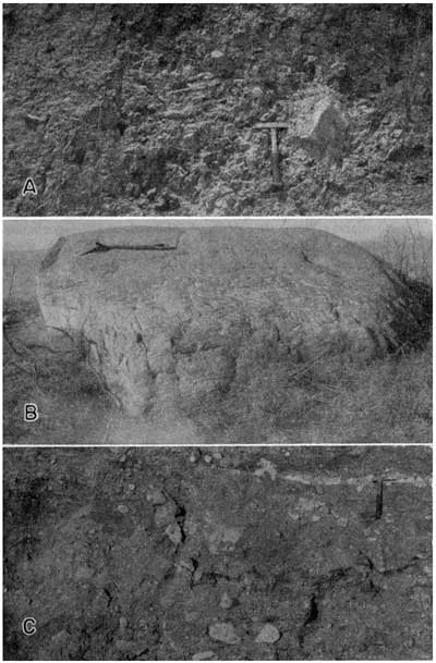
Irregular bodies or lenses of intratill sand and gravel are found interstratified with the till. These glacial meltwater or glacio-aqueous deposits probably represent minor recessions of the Kansan ice sheet and may be found at any position within the till.
Glacial till, because of its low permeability, is a very poor aquifer. Some of the intratill deposits are good aquifers, especially deposits composed of coarse sand and gravel containing a minimum of incorporated silt and clay. A small intratill deposit that is surrounded by relatively impermeable till and is not connected to other extensive glacio-aqueous deposits may fail as an aquifer because of insufficient recharge. Although the permeability and thickness of intratill deposits differ greatly, most farm and domestic wells penetrating such deposits lying below the water table have adequate yields.
Meade Formation
The Meade formation, which includes outwash deposits made by the retreating Kansan glacier, is divided into two members, the Grand Island member below and the Sappa member above.
The Grand Island member, which occurs in relatively high terrace positions along the major streams in the county, is composed predominantly of sand and well-rounded granitic gravel. Two very large gravel pits in secs. 19 and 30, T. 4 S., R. 7 E. show a thickness of approximately 30 feet of gravel of the Grand Island member over-lain gradationally by silt and sand of the Sappa member.
The Sappa member of the Meade formation is composed of clay and stratified silt and fine sand. The Pearlette volcanic ash bed, which occurs within the Sappa member, is a very useful stratigraphic marker. Exposures of Pearlette ash were found along State Highway 9 in sec. 11, T. 4 S., R. 9 E. and near the cen. S. line sec. 35, T. 2 S., R. 7 E.
Because the boundaries of the Meade formation cannot always be recognized, and owing to the patchy occurrence of the formation in most parts of the county, it is mapped with other terrace deposits as undifferentiated terrace deposits, and the boundaries shown are approximate. The Grand Island member is highly permeable and is capable of yielding large quantities of water; however, due to its relatively high topographic position in Marshall County, only the lower part of the member is saturated in most places. Terrace deposits of the Grand Island member along the south side of Little Blue River and along Big Blue River south of Blue Rapids furnish moderate to large quantities of water to wells. The municipal wells of Blue Rapids and Irving obtain water from gravel of the Grand Island member. The Sappa member does not yield water to wells in Marshall County.
Sanborn Formation
The Sanborn formation in Marshall County consists of eolian silt or loess derived largely from the flood plains of streams carrying outwash from late Pleistocene glaciers north of this area.
The basal member of the Sanborn formation, the Crete sand and gravel member, was not recognized in Marshall County.
The Loveland silt member of the Sanborn formation occurs as a loess mantle on many of the upland divide areas and high terrace surfaces of Marshall County. The thickness of Loveland loess penetrated in some test holes could not be determined accurately because of the difficulty in recognizing the contact between the base of the Loveland loess and the top of the Sappa member. The Loveland member is typically a massive reddish-tan silt with a well-developed soil zone (Sangamon) at the top.
The Peoria silt member of the Sanborn formation also occurs as a mantle on the upland divide areas and high terrace surfaces and is much more widespread than the Loveland silt member. The Peoria silt member is a massive tan silt and contains the Brady soil at the top. The thickness of the Peorian in Marshall County probably does not exceed 10 feet anywhere.
The upper member of the Sanborn formation, the Bignell silt member, was not recognized in Marshall County.
The Sanborn formation lies above the water table in Marshall County and does not yield water to wells.
Alluvium
Alluvial deposits of sand, gravel, silt, and clay attaining thicknesses as great as 50 feet underlie the flat valley bottoms of the area. The alluvium of the streams in Marshall County is late Pleistocene (Recent) in age.
Sand and gravel beds in the alluvium are highly permeable, and due to their low topographic position are generally below the water table and yield large quantities of water to wells.
Quality of Water in Relation to Water-bearing Formations
The quality of water from typical wells deriving water from the principal aquifers in Marshall County is indicated by the analyses in Table 3 and is shown graphically in Figures 6 and 7. The quality of water in the principal aquifers of the county is discussed below.
Figure 6--Typical analyses of water from Quaternary aquifers in Marshall County. A larger version of this figure is available.
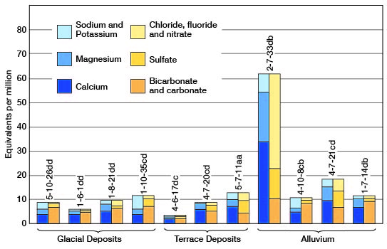
Figure 7--Typical analyses of water from Permian aquifers in Marshall County. A larger version of this figure is available.
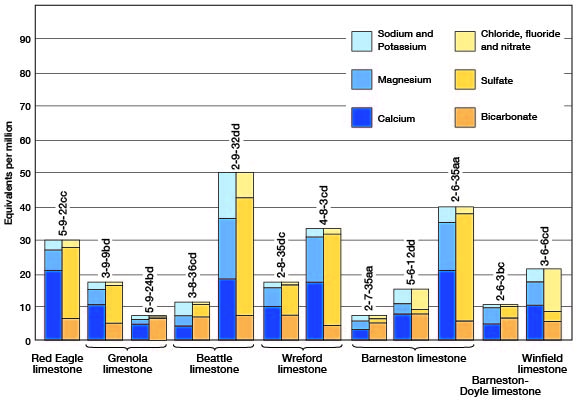
Red Eagle limestone--Only one sample of water from the Red Eagle limestone was analyzed (well 5-9-22cc); it contained 1,908 parts per million of dissolved solids and had a hardness of 1,349 parts per million of which 1,011 parts was noncarbonate hardness. The chloride and fluoride contents of the water were low, and the iron content was 0.14 part per million. The sulfate and nitrate contents were high, indicating the possibility of contamination.
Grenola limestone--Samples of water from wells 3-9-9bd and 5-9-24ba, which obtain water from the Grenola limestone, differed considerably in quality. Water from well 3-9-9bd contained 1,080 parts per million dissolved solids and had a sulfate content of 551 parts per million. The total hardness of this sample was 741 parts per million. Water from well 5-9-24ba contained 387 parts per million dissolved solids and had a sulfate content of 23 parts per million. The total hardness of this sample was 328 parts per million. The chloride, fluoride, and nitrate contents of water from both wells were low.
Beattie limestone--Samples of water from two wells obtaining water from the Beattie limestone (wells 3-8-36cd and 2-9-32dd) differed considerably in chemical quality. The water sample from well 2-9-32dd contained 3,113 parts per million dissolved solids, 1,689 parts per million of sulfate, 264 parts per million of chloride, and had a total hardness of 1,832 parts per million. The water sample from well 3-8-36cd contained 672 parts per million dissolved solids, 205 parts per million sulfate, and 12 parts per million chloride and had a total hardness of 353 parts per million. The fluoride and nitrate contents of water from both wells were low. Well 2-9-32dd may have been contaminated by water from gypsum-bearing beds.
Wreford limestone--Samples of water from wells 2-8-35dc and 4-8-3cd, which obtain water from the Wreford limestone, contained respectively 1,037 and 2,137 parts per million dissolved solids and 467 and 1,400 parts per million sulfate; they have total hardnesses of 780 and 1,545 parts per million. The chloride, fluoride, and nitrate contents of water from both wells were low.
Barneston limestone--Samples of water from four wells obtaining water from the Barneston limestone differed considerably in chemical quality. The dissolved solids content of the four samples ranged from 409 to 2,495 parts per million, the sulfate content ranged from 31 to 1,538 parts per million, and the total hardness ranged from 290 to 1,757 parts per million. One sample (5-6-12dd) contained excessive nitrate (328 parts per million).
Winfield limestone--Only one sample of water from the Winfield limestone was analyzed (well 3-6-6cd); it contained 1,388 parts per million of dissolved solids and had a hardness of 876 parts per million. This sample contained 500 parts per million nitrate, and the sulfate and chloride contents were relatively high.
Glacial deposits--Nine samples of water from glacial deposits were analyzed. The samples ranged in total dissolved solids from 342 to 983 parts per million, and the hardness ranged from 240 to 556 parts per million. The sulfate content ranged from 8.2 to 387 parts per million, chloride from 11 to 60 parts per million, and nitrate from 0.40 to 97 parts per million. The fluoride content of all samples was low.
Terrace deposits--Samples of water from four wells deriving water from terrace deposits ranged from 198 to 1,074 parts per million dissolved solids, and from 186 to 738 parts per million, total hardness. The sulfate content of the four samples ranged from 22 to 321 parts per million, chloride from 7 to 137 parts per million, and nitrate from 19 to 97 parts per million. The fluoride content of all samples was low.
Alluvium--Three samples of water from wells deriving water from alluvium were quite similar in chemical quality. The concentration of dissolved solids in these three samples ranged from 469 to 648 parts per million, and the total hardness ranged from 312 to 531 parts per million. The sulfate content of the samples ranged from 38 to 60 parts per million. The chloride, nitrate, and fluoride contents of these samples were low.
A sample of water from a fourth well (2-7-33db) deriving water from alluvium contained 3,887 parts per million dissolved solids and had a total hardness of 2,709 parts per million. The sulfate content of this sample was 599 parts per million, the chloride content 770 parts per million, and the nitrate content 1,084 parts per million. This well is located downgrade from a barnyard and seemingly is being contaminated by surface seepage.
Prev Page--Permian System || Next Page--Regions
Kansas Geological Survey, Geologic History of Kansas
Comments to webadmin@kgs.ku.edu
Web version March 2004. Original publication date March 1954.
URL=http://www.kgs.ku.edu/General/Geology/Marshall/06_geol3.html