![]()
Prev Page--Geography || Next Page--Recharge and Discharge
Ground Water
Principles of Occurrence
The following discussion of the occurrence of ground water has been adapted from Meinzer (1923) and the reader is referred to his report for a more detailed discussion. A general discussion of the principles of ground-water occurrence with special reference to Kansas has been made by Moore and others (1940). The rocks that make up the crust of the earth generally are not solid, but have numerous openings, called voids or interstices, which may contain air, natural gas, oil, or water. The many different kinds of rocks differ greatly in the number, size, shape, and arrangement of their interstices; therefore, the occurrence of water in any region is determined by the geology of the region.
The interstices or voids in rocks range in size from microscopic openings to huge caverns found in some limestones. The porosity of a rock is expressed quantitatively as the percentage of the total volume of the rock that is occupied by interstices or that is not occupied by solid rock material. Uncemented gravel deposits having a uniform grain size have a high porosity, whereas deposits made up of a mixture of sand, clay, and gravel may have a very low porosity because the smaller particles occupy the space between adjacent large particles. Relatively soluble rock such as limestone, though originally dense, may become cavernous as a result of the removal of part of its substance through the solvent action of percolating water. Hard, brittle rock may acquire large interstices through fracturing that results from shrinkage or deformation of the rocks or through other agencies.
The hydraulic permeability or perviousness of a rock is its capacity for transmitting water under pressure and is measured by the rate at which it will transmit water through a given cross section under a given difference of head per unit of distance. A rock containing many very small interstices may be very porous but difficult to force water through, whereas a coarser grained rock that may have less porosity may be much more permeable. The specific yield of a rock or soil, with respect to water, is the ratio of (1) the volume of water that, after being saturated, it will yield by gravity to (2) its own volume. This ratio may be stated as a percentage. The specific retention of a rock is the ratio of (1) the volume of water which, after being saturated, it will retain against the pull of gravity to (2) its own volume.
The permeable rocks that lie below a certain level are generally saturated with water under hydrostatic pressure. These saturated rocks are said to be in the zone of saturation (Fig. 4). The zone of saturation ordinarily extends down to a depth much greater than is reached by modern drilling methods. The term internal water may be applied to the water in the interior of the earth where the pressure of overlying rocks is so great that interstices cannot exist. The term ground water is used to designate that part of the subsurface water within the zone of saturation. The upper surface of the zone of saturation is called the ground-water table, or simply the water table. In most places there is only one zone of saturation, but in certain localities the water may be hindered in its downward course by an impermeable or nearly impermeable bed to such an extent that an upper zone of saturation, or perched water body, not associated with the lower zone of saturation, is formed.
Figure 4--Diagram showing divisions of subsurface water (after O.E. Meinzer).
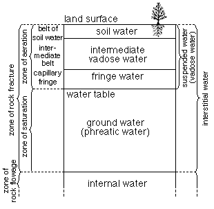
All rocks above the water table are in the zone of aeration, which ordinarily consists of three parts: the belt of soil water; the intermediate, or vadose zone; and the capillary fringe.
The belt of soil water, which contains water held by molecular attraction, lies just below the land surface and extends down to the maximum depth at which evaporation and plant action occur. The water in the belt of soil water is not available to wells but is of the utmost importance to agriculture. In this belt the amount of water must exceed that which will be held by molecular attraction before any water can percolate downward to the water table. The belt of soil water is limited in thickness by the texture of the rock or soil, and by the character of the vegetation.
The space between the lower limit of the belt in which water can be withdrawn by plant action and the upper limit of the capillary fringe forms an intermediate belt which is thick where the depth to the water table is great and may be absent where the water table is at or near the surface. In this belt the interstices in the rocks contain some water held by molecular attraction but also may contain appreciable quantities of water while it is moving downward from the belt of soil moisture to the water table.
The capillary fringe lies directly above the water table and is formed by water held above the zone of saturation by capillary force. The water in the capillary fringe is not available to wells, which must be deepened to the zone of saturation before water will enter them. The capillary fringe may be very thin in coarse-grained sediments, in which the capillary action is negligible, or it may be several feet thick in fine-grained sediments.
Artesian Conditions
Artesian conditions exist where a water-bearing bed is overlain by an impermeable or relatively impermeable bed that dips from its outcrop to the discharge area. Water percolates downward to the water table at the point of outcrop of the water-bearing bed, and then moves down dip beneath the overlying impermeable bed. The hydrostatic pressure of the ground water is due to the weight of water at higher levels in the water-bearing bed, or aquifer as it is usually called. The pressure head of water at a given point in an aquifer is its hydrostatic pressure expressed as the height of a column of water that can be supported by the pressure. The pressure head is the height that a column of water rises in a tightly cased well that has no discharge. If the pressure in the aquifer is sufficient to lift the water above the top of the aquifer, artesian conditions are said to exist. The difference in height between the point of outcrop of the aquifer and the point of discharge must be sufficient to develop a pressure equal to the weight of the column of water in the well plus the loss of head by friction in the aquifer before a well will flow at the surface.
No flowing wells were encountered in Marshall County; however, many wells obtaining water from limestone have artesian pressure. Many wells in glacial material have artesian pressure because dipping lenses of sand and gravel are overlain by relatively impermeable clay.
The Water Table and Movement of Ground Water
The water table has been defined as the upper margin of the zone of saturation. The zone of saturation is, in a sense, a ground-water reservoir just as a lake or river is a surface-water reservoir. The water table is not a static, level surface; generally it is a sloping surface having many irregularities and is constantly changing. There are many causes of irregularities and fluctuations in the water table.
Ground water moves in the downslope direction of the water table, but this movement is very slow because of the frictional resistance offered by the small interstices through which the water must pass. In an area where conditions are suitable for a high rate of recharge, water may percolate down to the water table faster than it can spread out and a mound or ridge is formed in the water table. By the same process, if water is withdrawn from the zone of saturation faster than it can flow in laterally, the water table is lowered locally forming an inverted cone or a trough. The permeability of the water-bearing material has a significant effect upon the slope of the water table. In a fine-grained deposit having a low permeability the slope of the water table must be much steeper than in a coarse-grained, highly permeable deposit in order to have the same rate of flow.
In the parts of Marshall County where glacial deposits are thick and the surface is dissected, the water table is as near the surface on the hill tops as it is in many of the adjacent alluvial valleys. This is probably because the glacial deposits in the hills are relatively impermeable and the slope of the water table toward the valleys is quite steep, whereas the more highly permeable alluvium in the valleys allows rapid downstream movement of the water at a lower gradient.
In Marshall County the water confined in permeable limestone beds by relatively impermeable shale beds moves in the direction of regional dip, which is to the west.
Prev Page--Geography || Next Page--Recharge and Discharge
Kansas Geological Survey, Geologic History of Kansas
Comments to webadmin@kgs.ku.edu
Web version March 2004. Original publication date March 1954.
URL=http://www.kgs.ku.edu/General/Geology/Marshall/05_gw.html