![]()
Prev Page--Abstract || Next Page--Geography
Introduction
Purpose and Scope of the Investigation
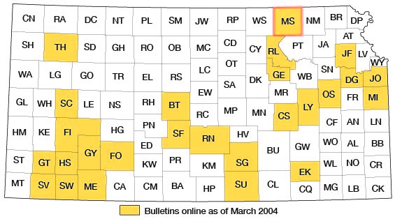
A program of investigation of the ground-water resources of Kansas was started in 1937 by the State Geological Survey of Kansas and the United States Geological Survey, in cooperation with the Division of Sanitation of the Kansas State Board of Health and the Division of Water Resources of the Kansas State Board of Agriculture. The purpose of this program is to survey county areas and major stream valleys or irrigation districts to determine the availability of ground-water supplies. The present status of investigations resulting from this program is shown in Figure 1.
Figure 1--Index map of Kansas showing area described in this report and areas covered by other online geologic reports, as of March 2004. For additional information, please visit the KGS Geologic Maps of Kansas Page.
As a part of this program, an investigation of the geology and ground-water resources of Marshall County was begun in June 1951. Ground water is one of the most important natural resources of Marshall County; 9 municipal water supplies and nearly all domestic and stock supplies are obtained from wells. Increased availability of electricity in rural areas and the use of domestic and industrial practices which require larger amounts of water have increased materially the rate of withdrawal of ground water in the last decade. The principal purpose of this investigation has been to provide information necessary to the satisfactory and economical development of domestic, stock, industrial, and municipal ground-water supplies.
The investigation was made under the general direction of A. N. Sayre, Chief of the Ground Water Branch of the United States Geological Survey, and under the immediate supervision of V. C. Fishel, District Engineer in charge of ground-water work in Kansas.
Previous Investigations
Although a detailed study of the geology of Marshall County has not been made previously, early reports concerning the areas of Marshall County where gypsum was mined or was known to occur were written. Mudge (1866) and Grimsley and Bailey (1899) made the most important of these early studies. Haworth (1913) discussed in some detail the geology and ground water of Blue River Valley and more generally the water-bearing characteristics of glacial drift and Permian formations.
In 1940 Moore and others prepared a generalized report on the ground-water resources of Kansas including Marshall County. Jewett (1941) made a study of the geology of Riley and Geary Counties; Riley County borders Marshall County on the southwest. A report published in 1942 (Lohman and others) on the availability of ground-water supplies for national defense industries in Kansas includes a description of the availability of ground-water supplies in Big Blue River Valley and discusses general ground-water conditions in northeastern Kansas. The subsurface stratigraphy as related to oil and gas exploration has been discussed by Lee (1943), by Jewett and Abernathy (1945), and by Jewett (1949). Fairchild (1949) made a study of the geology and petrography of the gypsum deposits near Blue Rapids in Marshall County. Geologic cross sections and interpretations of test hole data in Marshall County are included in a report by Frye and Walters (1950). A summary of the stratigraphic sequence of rocks in Kansas was prepared by Moore and others (1951).
Methods of Investigation
Five months in the summer and fall of 1951 were spent in the field collecting the data upon which this report is based. Geologic mapping in the field was done on aerial photographs from field observations and stereoscopic study of the photographs. A base map of the county was made by Bernita K. Mansfield from a county map prepared by the Soil Conservation Service, and the geologic mapping was transferred to it from the aerial photographs by the use of a vertical sketchmaster.
Data on the depth, depth to water, yield, and character of the water-bearing material of 248 wells (Table 11) were collected. Many of these wells were measured with a steel tape; however, some depths and water levels were reported by the owner or driller.
The material below the land surface was determined by drilling 60 test holes (P1. 3) through the unconsolidated sediments and into the underlying limestone or shale of Paleozoic age. Data on 20 test holes drilled in 1949 as a part of an earlier study are included in this report. All test holes were drilled with the hydraulic rotary drilling machine owned by the State Geological Survey of Kansas and operated by William T. Connor and Max Yazza during the season of 1949 and by Connor and Norman W. Biegler during the season of 1951. Logs of the test holes were prepared in the field; later well cuttings were examined microscopically in the laboratory. Level parties headed by Woodrow W. Wilson and Norman W. Biegler determined the altitude of the land surface at each test hole by using a plane table and alidade.
Samples of water from 30 wells in the county were collected and chemical analyses of them were made by Howard Stoltenberg, chemist in the Water and Sewage laboratory of the Kansas State Board of Health.
The stratigraphic sections included in this report were measured by field parties supervised by Frank E. Byrne of the United States Geological Survey.
Well-numbering System
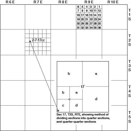
In this report, wells and test holes are numbered according to their location as given by the General Land Office system of land classification. The component parts of a well number are the township number, the range number, the section number, and the two lower case letters which indicate, respectively, the quarter section and the quarter-quarter section in which the well is located. The lower case letters are assigned in counterclockwise order begin-fling with the letter a, in the northeast quarter or quarter-quarter section. For example, well 2-7-17cc (Fig. 2) is in the SW1/4 SW1/4, sec. 17, T. 2 S., R. 7 E. If two or more wells are within the same quarter-quarter section, the wells are numbered serially according to the order in which they were inventoried.
Figure 2--Map of Marshall County illustrating the well-numbering system used in this report.
Acknowledgments
Many residents of Marshall County gave permission to measure their wells and supplied helpful information about them. The city officials of the cities of Marshall County contributed data on municipal water supplies and several water well drillers operating in the area furnished logs and other pertinent data concerning water supplies. Albert Carlson, retired well driller, supplied information on many of the old wells in the county.
The manuscript for this report has been reviewed critically by several members of the Federal and State Geological Surveys; by Robert Smrha, Chief Engineer, and George S. Knapp, Engineer, Division of Water Resources, Kansas State Board of Agriculture, and by Dwight Metzler, Director, and Willard Hilton, Geologist, of the Division of Sanitation of the Kansas State Board of Health. The illustrations were drafted by Woodrow W. Wilson and David E. Gray of the Federal Geological Survey.
Prev Page--Abstract || Next Page--Geography
Kansas Geological Survey, Geologic History of Kansas
Comments to webadmin@kgs.ku.edu
Web version March 2004. Original publication date March 1954.
URL=http://www.kgs.ku.edu/General/Geology/Marshall/03_intro.html